Bedding in this pair of lithofacies is characterised by flat, relatively planar laminae a few grains thick, uninterrupted by cross stratification. They generally form in fine- to medium-grained sand. Laminae thickness is measured in millimetres.
Observations in modern flow systems, flume experiments, and the rock record presents us with two basic types of sand lamination that represent deposition at opposite ends of the hydrodynamic flow regime – one at lower flow plane bed, the other at upper flow plane bed.
The deposition of either sedimentary structure requires fairly specific hydraulic conditions.
Lower plane bed lithofacies
External structure
Laminae are flat, parallel, usually horizontal or close to it, and develop in fine- to very fine-grained sand; there may also be a component of silt. Laminae sets (i.e., multiple laminae) are usually a few centimetres thick. Laminae may be disrupted by bioturbation – common in marine environments, or root structures if the laminae are associated with organic paleosols. They are commonly interbedded or laterally associated with ripple and small-scale trough or tabular crossbed lithofacies.
Internal structure
Layering is flat and relatively uninterrupted in outcrop profiles. Carbonaceous plant fragments and platy minerals such as micas are commonly concentrated along laminae surfaces. If there is sufficient differentiation of platy grains, there may be a propensity for slate-like parting or breakage.
Thin section examination will usually show random orientation of framework grains such as quartz and feldspar, but preferred orientation of mica grains.
Formation – hydraulic conditions
Laminar structures that develop in sand beds indicate bedload transport and deposition. In this case, the criteria indicating relatively low energy flow include grain size and the preferred alignment along bedding of platy grains such as mica. Note that, despite its high specific gravity, the platy habit of mica confers a hydraulic response equivalent to much coarser grains of quartz and feldspar.
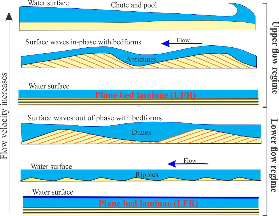
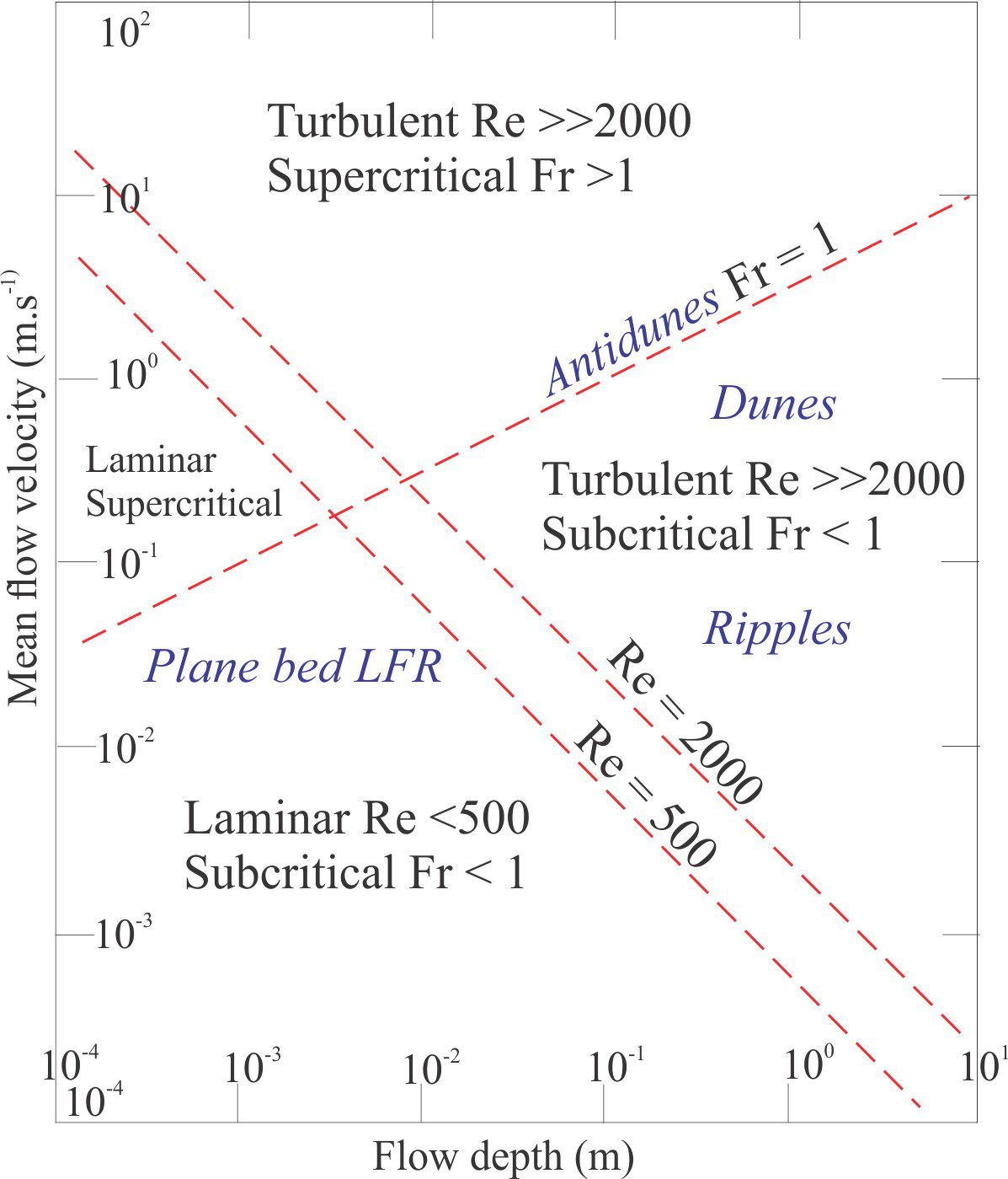
Observations in natural environments and in experiments indicate that the sandstone laminae form when flow is sufficient to initiate and maintain grain movement in a traction carpet but is insufficient to generate ripples. These conditions correspond to lower flow regime plane bed. Lower plane bed laminae occupy a restricted domain on the bedform stability diagram below. Laminar flow must be maintained; the water surface is essentially flat (low Froude and Reynolds numbers).
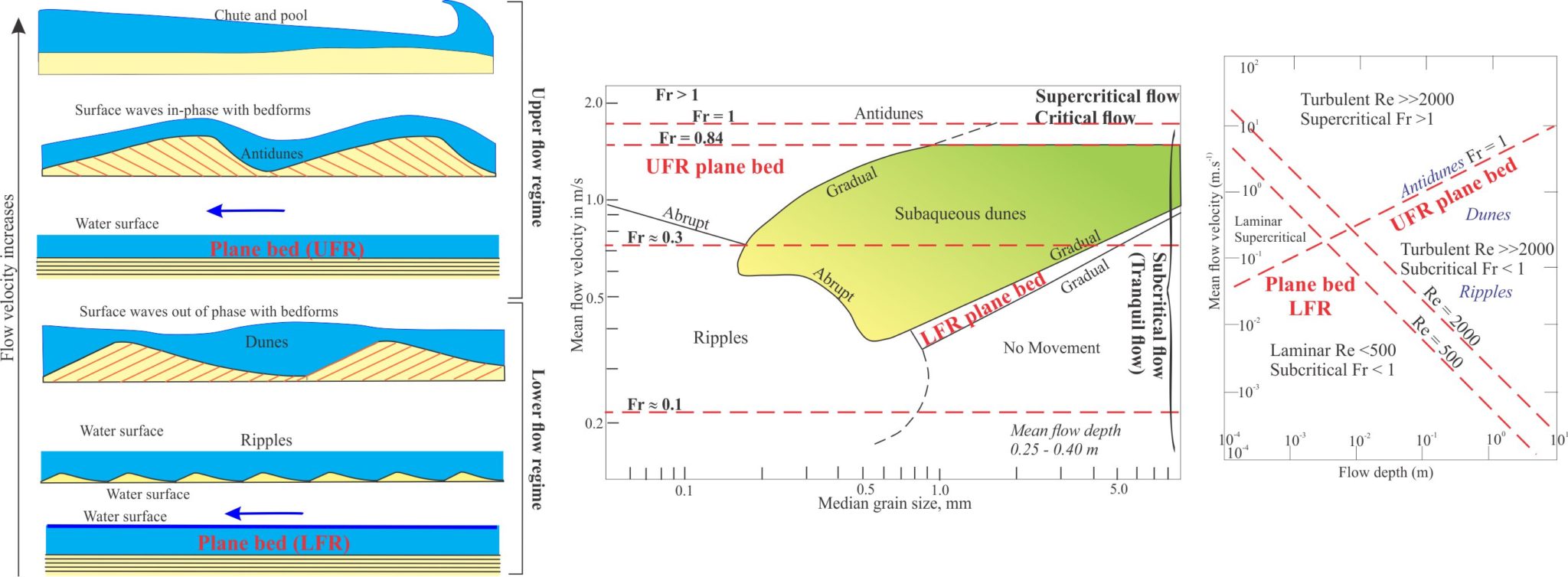
Summaries of the hydraulic conditions for deposition of upper flow regime bedforms, compared with other bedforms. Data for the graphical plots is mostly from flume experiments. 1- Flow Regime (left); after J.C. Harms & R.K. Fahnestock, 1965, 2- Median grain size and mean current velocities (centre); modified from Ashley, G.M. 1990, 3- Reynolds and Froude numbers as a function of flow depth and flow velocity (right); modified slightly from J.R.L. Allen,1992, Fig. 1.21. Plane bed fields are indicated in bold red type.
Common environments
Lower plane bed laminae can potentially form in marine and non-marine settings. However, the bedform occupies a fairly restricted domain on the bedform stability diagram which constrains the specific depositional environments. For example, it is unlikely the laminae would form in either fluvial or tidal channels, or in many coastal settings (in contrast with upper flow plane bed laminae – see notes below). Deposition of laminae may take place in the lower, deeper part of the shoreface if tidal flux is sufficiently weakened. However, in this case the preservation potential of the lithofacies might be lessened by storm surge disruption (evidenced by hummocky cross-stratification) and bioturbation.
In terrestrial settings, the most common occurrence of lower flow plane bed laminae is across flood plains, where sediment laden storm waters breach channel margins. The ability of overbank flow to move sediment bedloads and suspended loads decreases with increasing distance from the channel margin. The lithofacies can also overlie point bars in fine-grained, low sinuosity rivers where it may be associated with paleosols and coal-bearing strata.
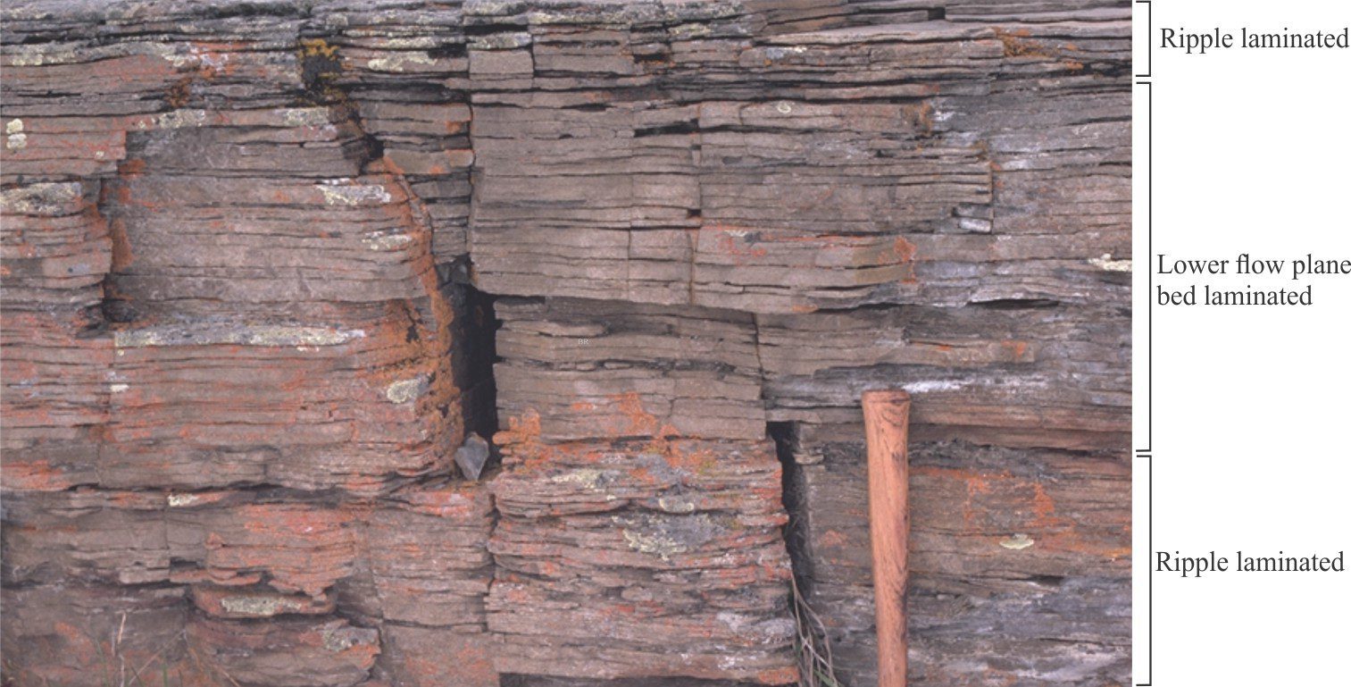
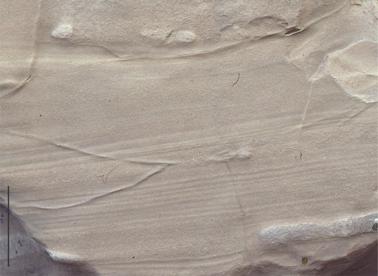
An interval, about 35 cm thick, of lower plane bed laminae in fine- to medium-grained fluvial overbank sandstone, overlain and underlain by sandstone containing low amplitude ripples (ripple lithofacies). Parting along bedding reveals significant amounts of carbonaceous plant fragments. There is also some mica. Cretaceous Kootenay Group, Alberta foothills.
Upper plane bed lithofacies
External structure
Parallel laminated sandstone is found in several depositional environments – fluvial, shallow marine, and some sediment gravity flows in marine and lacustrine settings. The common grain size of fine to medium sand is similar to that observed in lower plane bed deposits. Laminae are flat, horizontal or inclined, and occur in parallel sets measured in centimetres to decimetres thick where individual laminae are a few millimetres thick.
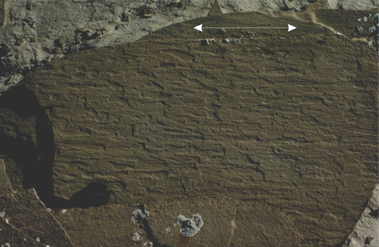
One sedimentary structure that distinguishes upper plane bed from lower plane bed laminae is parting lineation. Parting here refers to the splitting of laminated sandstone along bedding; lineation refers to the series of subparallel grooves and ridges, one to two grains thick, on exposed bedding. The long edges of both grooves and ridges approximately parallel the sediment transport direction – a useful indicator of paleocurrent flow although the actual flow direction is ambiguous unless there is corroborating evidence from other sedimentary structures.
Parting lineation in Paleogene distributary channel deposits, Canadian Arctic. The arrow shows two possible paleocurrent flow directions. Resolution of actual paleoflow direction can only be determined from associated crossbed lithofacies.
Internal structure
Parting lineation is only seen on surfaces exposed by splitting along the plane of the lamination. The lineation is caused by the alignment of grains about their long axes. Examination of oriented thin sections by McBride and Yeakel (1963; PDF available) demonstrated that the mean azimuth of quartz grains having elongations >2:1, closely paralleled the measured azimuths of parting lineations in the same sample. The closeness of fit was confirmed by Potter and Mast (1963) who noted the parallelism of parting lineation and associated crossbed azimuths.
Low density carbonaceous fragments are sparse on laminae surfaces; mica is noticeably less common compared with low-flow plane bed laminated sandstone.
Formation – hydraulic conditions
Upper flow regime plane bed laminae are deposited at flow velocities greater than those required for dune bedforms, but less than conditions that produce critical flow and the transition to antidunes. J.R.L. Allen’s (1992) explanation for parting lineation formed under these conditions is that small-scale, elongate vortices develop parallel to the direction of flow – the vortices form close to the sediment-fluid boundary and are responsible for creating streaks of grains along the flow boundary. Grain alignment is thought to occur within these streaks.
An alternative explanation offered by C. Paola et al., (1990), based on flume experiments that used high speed photography, posits the deposition of laminae associated with migration of very low-amplitude bedforms that form in response to small-scale turbulent fluctuations close to the flow boundary, followed by a ‘smoothing’ process.
Common environments
Upper flow plane bed lamination is relatively common in the rock record. It can form in fluvial channels under conditions where flood levels and flow velocities decrease rapidly – a prolonged falling stage may result in lower flow regime bedforms reworking the earlier deposited sands. Channels responding to flash floods can also produce this lithofacies. The proximal parts of crevasse splays, fan-shaped sand bodies that form when channel levees are breached by storm flows, also contain the laminated sand facies. The lithofacies has been found on the accretionary surfaces of sandy point bars, usually with shallow dips towards the channel (Miall, 2006); associate lithofacies include tabular and trough crossbeds, ripples, and scour surfaces.
Laminated sands with parting lineations and shallow seaward inclinations are common in the wave swash-backwash zone of sandy beaches. The lithofacies here is commonly associated with low-angle planar crossbedding. In marine environments the lithofacies is usually found near the top of coarsening-upward, prograding shoreface to beach successions.
Parallel lamination is very common in turbidites where it comprises the B division of Bouma sequences. However, deposition in this case is from a turbulent suspension, unlike the fluvial and beach examples noted above. B-division laminae are part of a continuum of changing flow dynamics as the degree of turbulence, flow velocity, and concentration of suspended sediment all decrease with time and flow run-out. The formation of laminae and associated parting lineations indicate a significant degree of shear at the boundary between the turbulent suspension and the accreting bed.
Parallel laminated sandstone in the B division in an Early Miocene turbidite. Individual laminae range from about 5 to 10 millimetres thick. North Auckland, New Zealand.
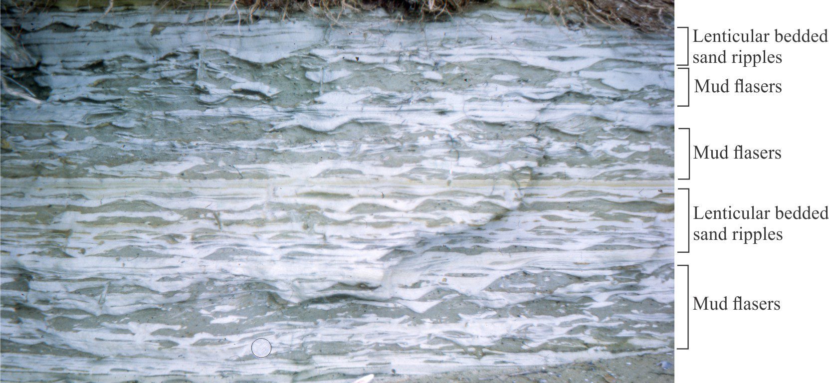
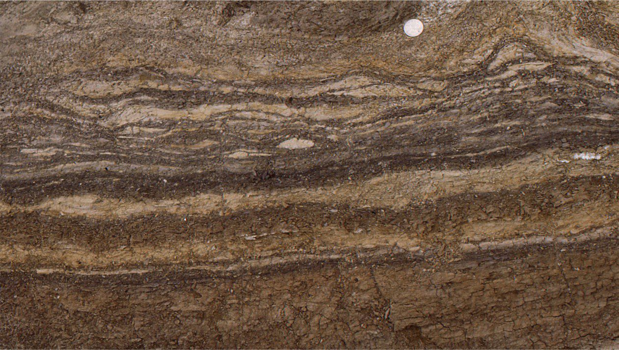
Lenticular and flaser bedding in Late Pleistocene intertidal – estuarine deposits. The sand ripples are dark grey hues, the mudstones pale grey. Manukau Harbour, west Auckland. Coin diameter at lower center is 25 mm.
Lenticular bedding, flaser bedding, and interference ripples
Most crossbeds and their associated bedforms cannot be linked directly to specific environments of deposition. For example, planar and trough crossbeds form in marine, fluvial, and aeolian settings and pin-pointing any one of these usually requires additional information. Likewise, current ripples are ubiquitous in marine and terrestrial environments. However, a small group of ripple bedforms can, with some confidence, be associated directly with tidal currents, where bedforms react to tidal current asymmetry (the fancy name for ebb-flood reversal of tidal currents). The value of this association is enhanced when other sedimentary structures of shallow marine origin are present. Tidal currents interact with the sea floor on all continental shelves and platforms, but their most profound influence on sedimentation is in intertidal environments. Three of these bedforms are described here: lenticular and flaser ripple bedding, and interference ripples.
Lenticular and flaser bedding are commonly found together. There is a complete gradation between the two types of bedding. They are best developed on mixed sand-mud tidal flats.
External form:
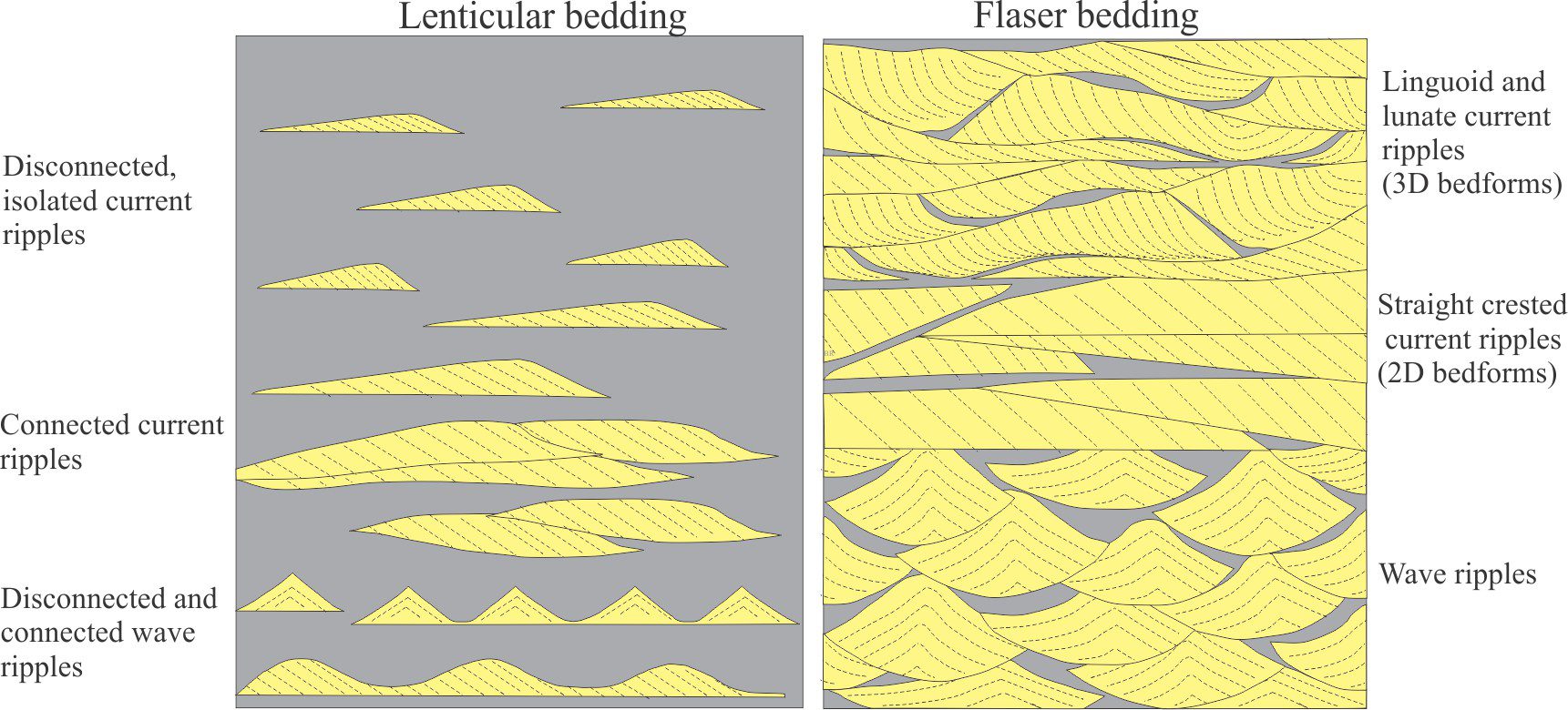
Reineck and Wunderlich (1968) provide a detailed description and classification of lenticular and flaser bedding – this is still one of the best sources of information. The term ‘lenticular’ derives from the ripple profile, where the lenticularity refers to lee face – stoss face symmetry. Lenticular bedding is characterized by sand ripples overlain by or encased in mudstone. Thus, ripples appear isolated, disconnected, or as locally connected bedforms. The proportion of mud in beds containing lenticular ripples is usually equal to or greater than that of sand.
Flaser bedding forms where the proportion of sand exceeds that of mud and is characterized by mud veneers or streaks that line or fill the troughs between successive ripples. The mud layers may overlap ripple crests.
Lenticular and flaser bedding form with both current and wave ripples. Thus, bedforms may have asymmetric or symmetric profiles, and crests that are straight, linguoid, or lunate.
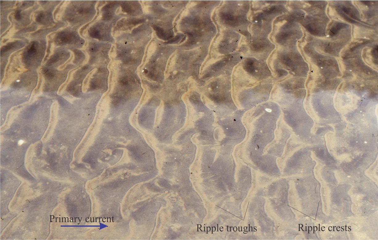
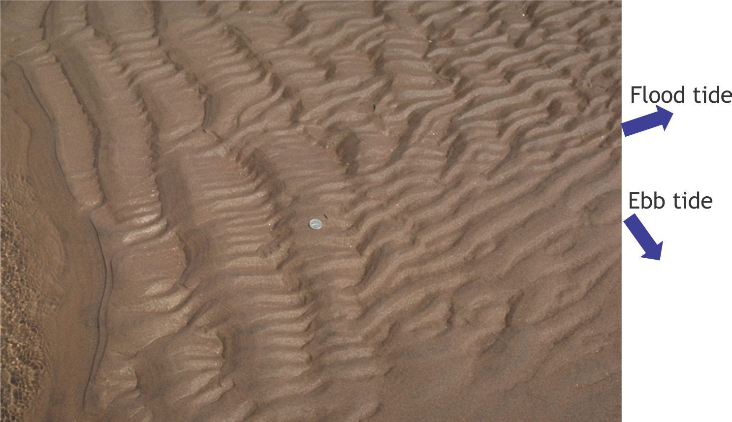
Mud flasers (pale brown) have accumulated in the troughs of these linguoid (and a few lunate) ripples on an intertidal flat – the ripples formed during a flood tide. In this example, clay and silt were stirred into the shallow tidal waters during a storm. The mud was deposited from suspension to the intervening troughs during slack tide when bottom currents were at their lowest velocity. Depending on the relative strength of the subsequent ebb currents, the flasers may be preserved or modified. The bed in the lower half of this view is partly covered by water. Field of view is 80 cm wide.
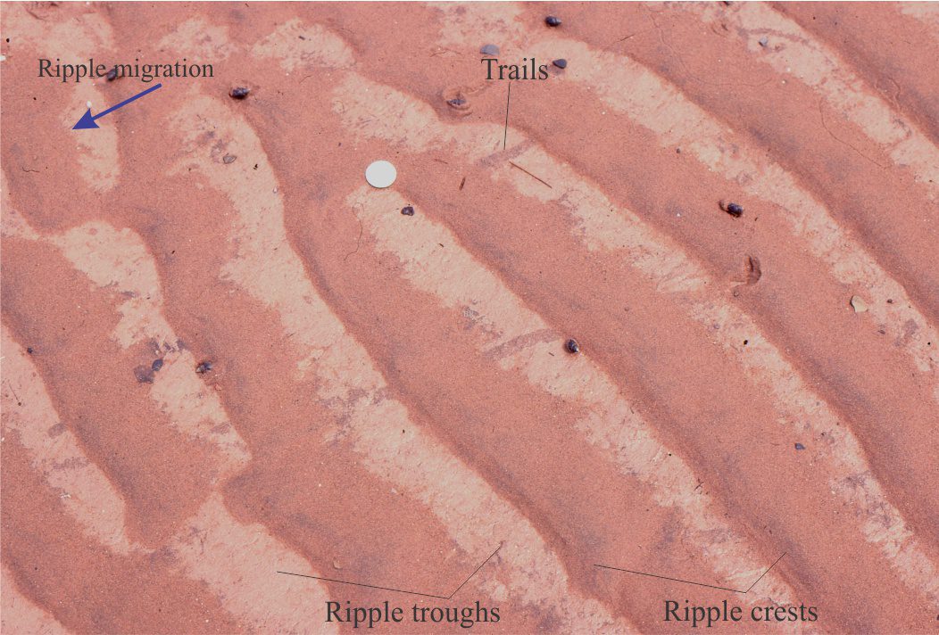
Straight crested sand ripples (deep red hues) have migrated over a muddy substrate; trails in the mud layer have been over-ridden by the ripples. This is a recent example of lenticular bedding, where successive ripples are disconnected. There is a superficial resemblance to flaser bedding, but in this example the mud layer was deposited before the ripples. Here, the ripples formed during the flood tide cycle. Coin diameter (top left) is 24 mm.
Internal structure:
Diagrammatic representation of lenticular (left) and flaser bedding (modified from Reineck and Wunderlich, 1968). Lenticular bedding is represented by isolated and connected wave and current ripples. The flaser bedding panel shows straight crested (2D) and linguoid – lunate (3D) bedforms and (grey) mud flasers. Note, the 3D bedforms have scoured, spoon-shaped bases and concave crossbed foresets). Each field of view is 50 cm wide.
Current ripple bedforms in lenticular and flaser bedding contain typical lee-stoss face asymmetry, and foresets that dip downflow. Wave-generated bedforms are symmetrical and may contain opposing foresets, or foresets having a dominant dip direction depending on wave orbital geometry. Each ripple may be isolated or overlap (and partly erode) other ripple sets. Mud that drapes or encases lenticular ripples may be laminated and commonly contain discontinuous sand laminae. Bioturbation is common; there may also be macro- and microfossils.
Mud flasers are preserved as isolated, wispy veneers or lenses overlying or filling ripple troughs. Ripple cosets may contain several flasers.
Paleocene estuarine or tidal flat deposits containing lenticular ripple bedding (light coloured sandstone in upper half of image) encased in and draped by dark grey, carbonaceous mudstone laminae. Ripple migration was to the left. Ellesmere Island. Coin diameter is 24 mm.
Formation – hydraulic conditions:
Lenticular bedding and the ripples overlapped by flaser bedding form in the same way as standard current and wave ripples. Their distinctiveness derives from an interaction with ebb and flood tidal currents. Both types of structure form when either the ebb or flood tidal currents dominate, with the mud layers accumulating during the opposite, much weaker flow.
Common environments
Both structures form on mixed sand-mud tidal flats in marine embayments, lagoons and estuaries that are subjected to tidal exchange. Note that neither bedform indicates which tidal flow was responsible for their development, but instead points to the relative strength or competence of either ebb or flood flows. The real value of the lithofacies lies in the stratigraphic repetition of the bedforms that indicate a degree of regularity or periodicity of opposing current strengths, a periodicity that is difficult to explain in depositional settings other than a tidal environment (current reversals can develop locally in fluvial and aeolian depositional settings, but there is rarely any periodicity to such events).
Interference ripple lithofacies
General occurrence:
Interference ripples occur when one bedform coset, formed during either flood or ebb tidal flow, is modified by ripples formed during the opposing tide. For ripple interference to occur the directions of current flow must be less than 180o such that the two sets of ripple crests are oblique.
Interference ripples in fine-grained sand, Minas Basin, Bay of Fundy. The directions of tidal flow are indicated. The flood tide ripple sets have larger wavelengths than the ebb tide sets, indicating weaker currents in the latter. Both sets have relatively straight crests. Coin diameter is 24 mm.
External form:
Each ripple coset is formed by currents and hence will usually show lee – stoss face asymmetry. However, the first-formed ripples will also be modified – typically crests will be rounded or flattened by the opposing tidal flow. In addition, the crest lines of earlier-formed ripples will be dissected in a fairly regular fashion by the latest ripple coset.
Interference ripple patterns are more easily identified in straight crested bedforms than in 3D bedforms such as linguoid ripples. Exposure of both ripple sets on bedding is necessary for confident identification.
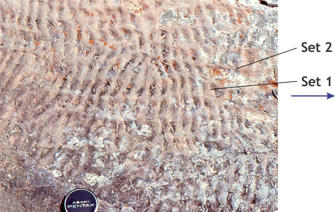
Two billion year-old interference ripples in fine-grained, mixed carbonate-siliciclastic sandstone. Both ripple sets have similar amplitudes but the wavelength of set 1 is about half that of set 2, indicating that the opposing tidal currents had slightly different velocities. Both ripple sets have straight to sinuous crests. Set 1 ripples (flow to the right) formed after and modified Set 2 ripples. Thus, the flow direction of Set 2 is ambiguous in this bedding exposure. Lens cap diameter is 50 mm. McLeary Formation, Belcher Islands.
Internal structure:
Ripple foresets will show lee-face preservation typical of most current ripples. In profile views there is little to distinguish interference ripples from other ripple types; bedding exposure is usually a prerequisite for positive identification.
Formation – hydraulic conditions:
The hydraulic conditions necessary for current ripples to form apply to both ripple cosets (see the companion post on current ripple formation). The change in direction of ripple migration is a function of the degree of asymmetry of opposing tidal flows.
Common environments:
Interference ripples are valuable indicators of tidal current asymmetry over tidal flats associated with lagoons, estuaries, and coastal embayments, particularly if they occur with lenticular and flaser bedding. Interference ripples will not form if the flood-ebb flow directions are directly opposite (i.e., 180o). They are more likely to form where ebb flow is deflected, for example by the formation of larger bedforms over the tidal flat, or by wind shear that pushes the shallow water masses in different directions (for example, during storm surges).
Neither ripple set can be equated with an ebb or flood tide. However, if the strike of a paleoshoreline can be determined from independent data, then it may be possible to assign ebb or flood status to a particular ripple set.
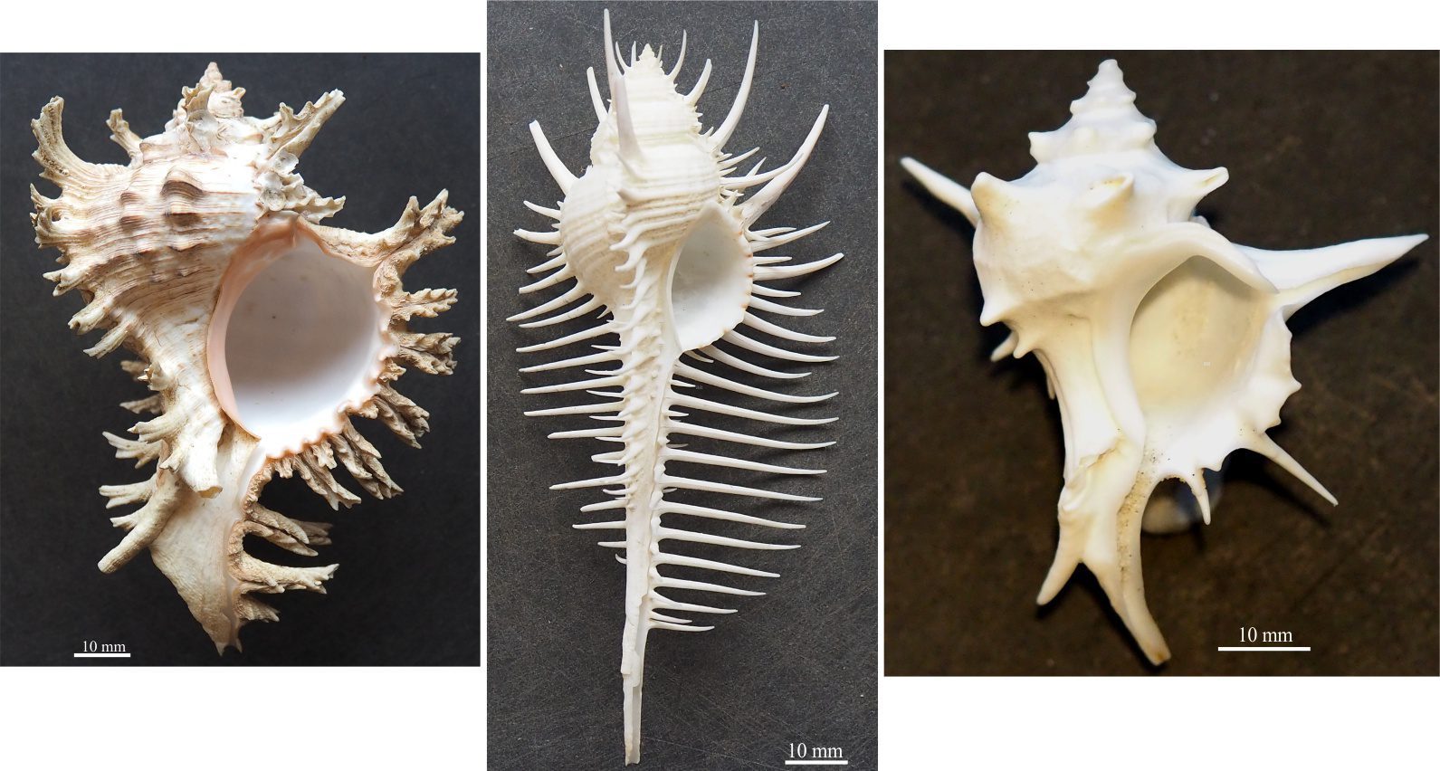
The sartorial splendour of spiny murex – the real show-offs in the world of gastropods. From the left: Chicoreus ramosus (the Ramose Murex, Philippines); Murex pecten (Venus comb Murex, Philippines); Porieria zelandica (New Zealand) – the one I stood on!
Some basic gastropod morphology to assist sedimentological interpretations
This is a companion post to bivalve shell morphology.
The world of snails is morphologically and taxonomically more diverse than that of bivalves. It has been estimated that globally the number of known living gastropod species is about 60,000 compared with about 20,000 bivalve species. In modern and fossil species, morphological variation is manifested by an astounding array of shell size, shape, and ornamentation – the latter exemplified by the sartorial splendour of spiny Murex.
Apart from the obvious morphological differences between bivalves and gastropods, there is also a methodological difference in their taxonomic subdivision. Identification of bivalve taxa is based on a combination of animal anatomy and shell morphology; for the latter, valve dentition is important. In comparison, modern gastropod taxa are based almost entirely on animal anatomy, except at the genus level where shell structure may be included. However, in both cases the identification of fossil forms depends primarily on a comparison of physical attributes with their modern descendants.
The majority of species are marine, but there are fresh water and air-breathing terrestrial species (pulmonates). The morphological attributes of these shells are similar to their marine cousins. There are also shell-less gastropods (nudibranchs) such as the common slug, but these have almost zero preservation potential.
In outcrop and core, gastropods will occur in various states of completeness, as small fragments to complete specimens; their preservation will depend on the kind of gastropod (e.g., thin shelled or thick, tall spires or planispiral, ornamented), the depositional environment, and the degree of sediment reworking (e.g., high or low, wave or tidal current energy). They will probably occur with other shelly fossils and may be accompanied by encrusting biotas such as bryozoa, corals, calcareous algae, and barnacles. There will probably be an associated trace fossil assemblage.
At a certain level of preservation, gastropod fragments will likely be indistinguishable from other molluscs, brachiopods, or barnacles (thin section examination may provide some relief from this dilemma).
However, there are many distinctive morphological elements that will provide a reasonable level of confidence if correctly identified. Some of the commonly used attributes are described here.
Other sources
There are lots… but here are a couple of links to recent texts.
The Paleontological Society provides free access to its Digital Atlas of Ancient Life that contains oodles of explanatory texts, field guides, Apps, and images on the fossil record.
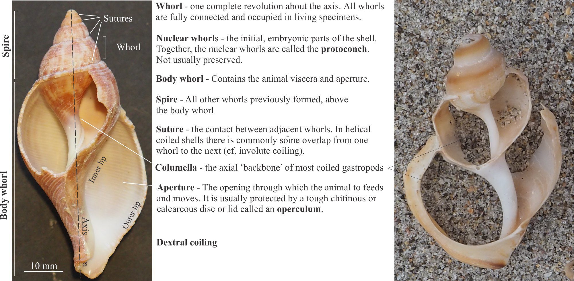
The standard orientation is to place the aperture at the bottom facing the observer, and the spire pointing upward. The aperture may open on the right side of a central column (the columella) indicating dextral coiling; opening on the left side indicates sinistral coiling. Most gastropods have dextral coiling.
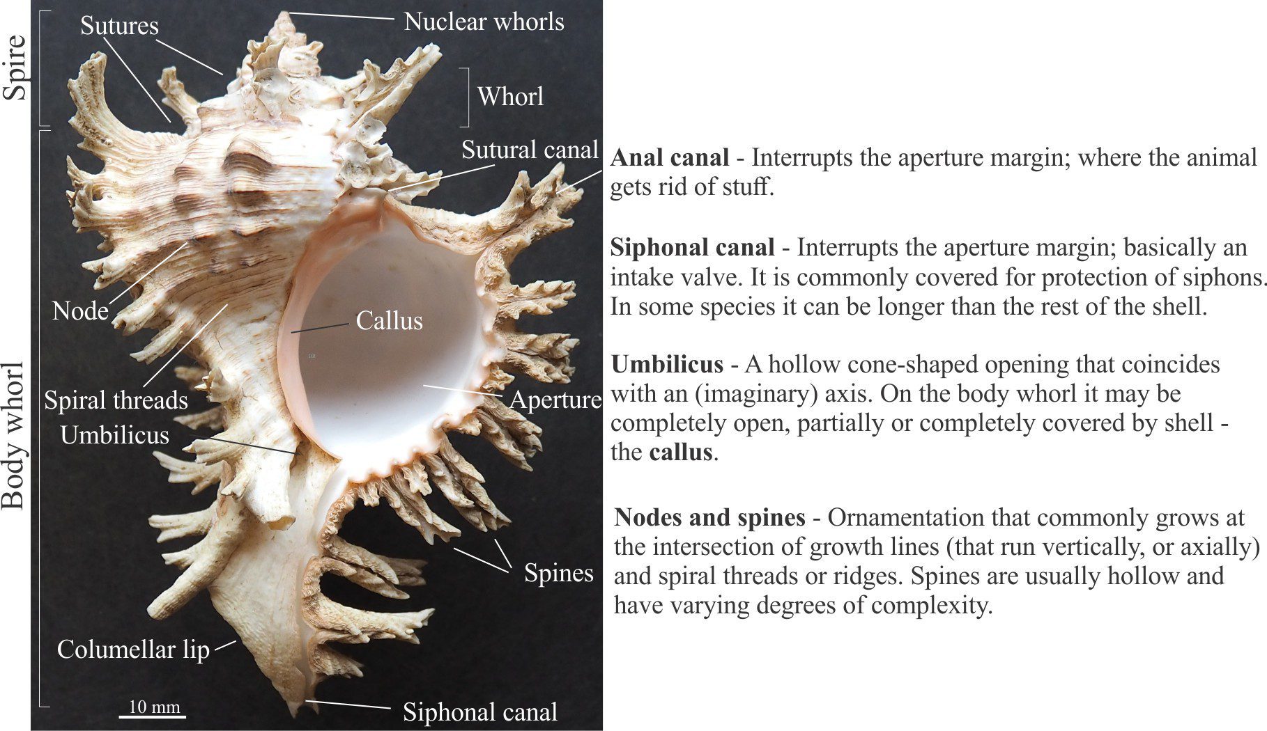
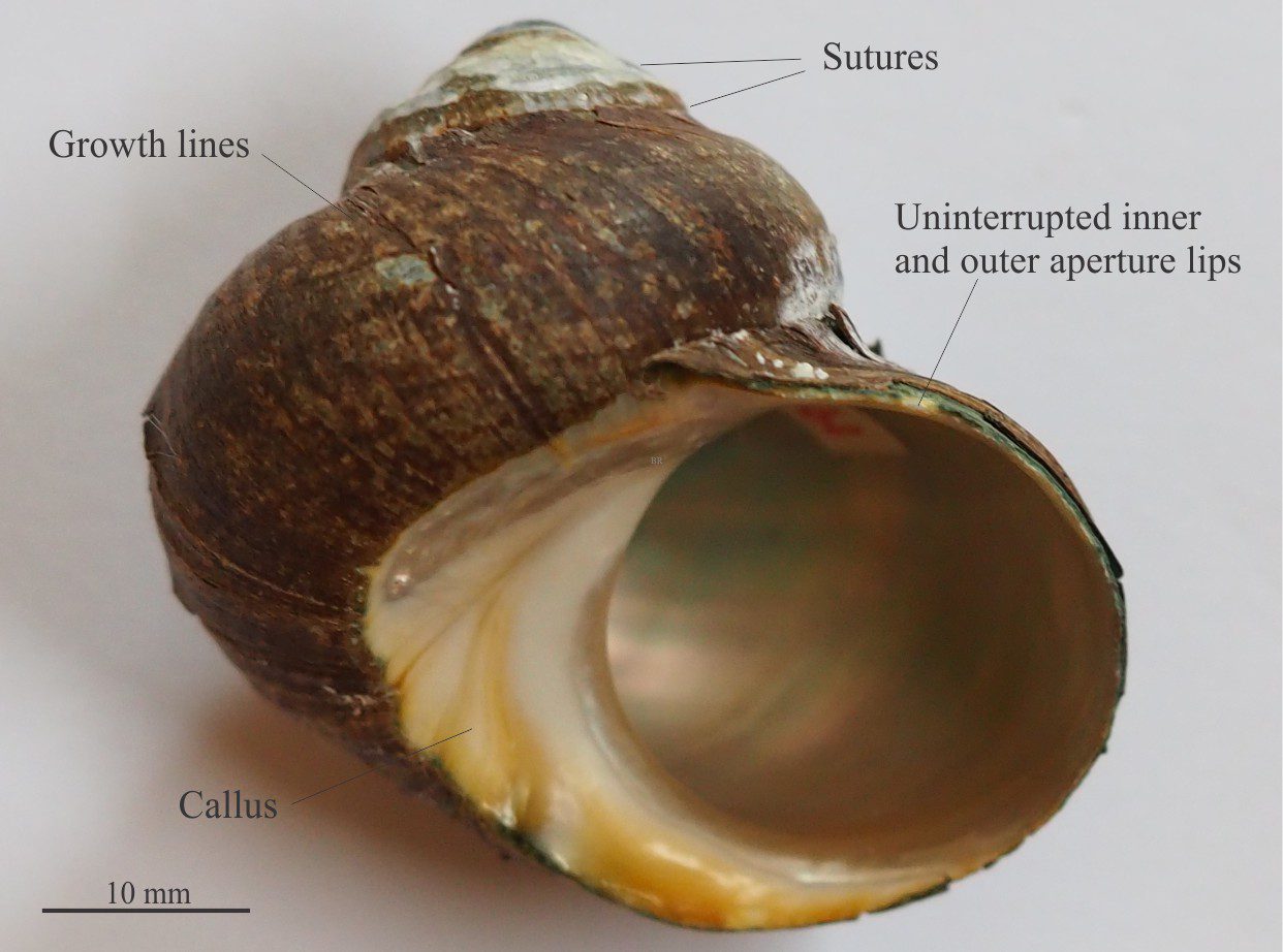
Left: A helically coiled gastropod (Fasciolaria) with part of the shell conveniently broken to reveal the axial columella. Other major morphological components are also identified. Right: Another view of the columella in the genus Struthiolaria. The aperture is facing down in this orientation.
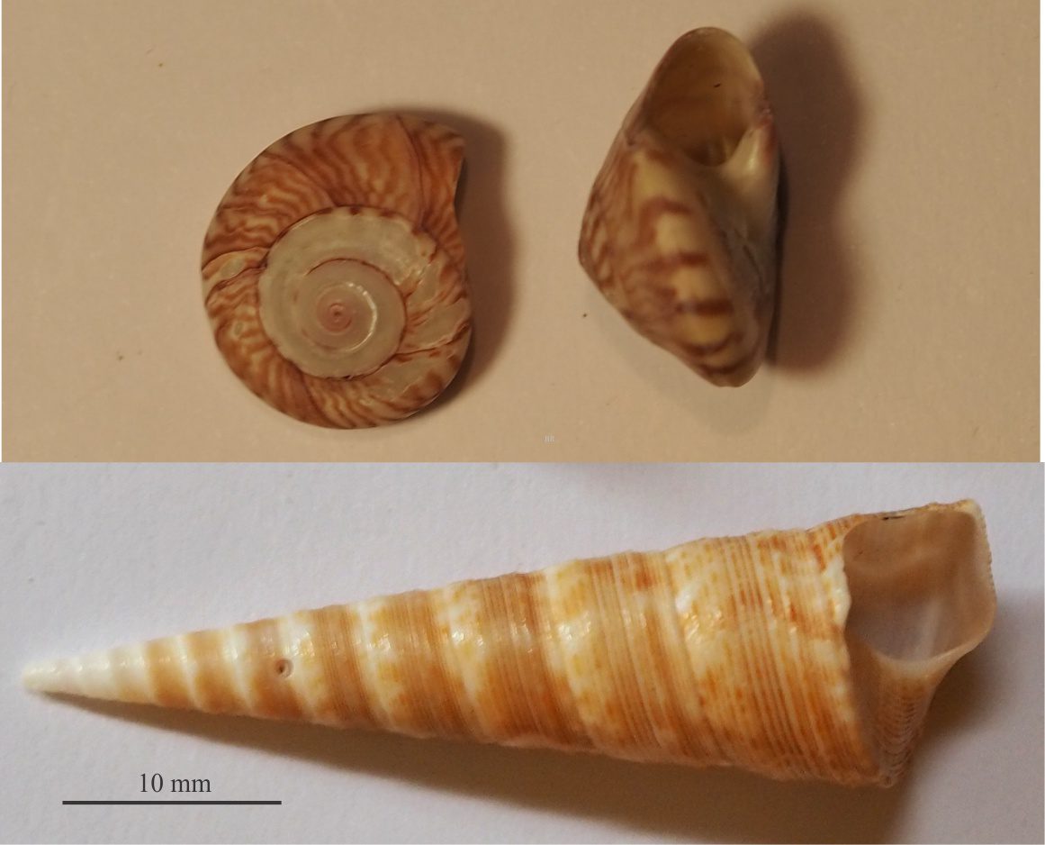
Coiling: Nearly all gastropods produce coiled shells. The variety in gastropod size and shape is primarily a function of the style of coiling. The most familiar shape consists of a body whorl (the open end) and a spire above, coiled in a cork-screw fashion – this is helical coiling. The angle between the body whorl and top of the spire defines the overall shape of the shell; very steep angles present turret shapes and tall spires (e.g., Maoricolpus), and at the other extreme very low angles produce discoidal forms (e.g., Umbonium (Zethalia)). Coiling in a single plane produces planispiral forms which also have bilateral symmetry (like many ammonites). In some species there may be no spire at all, such that the body whorl completely envelops the earlier whorls (involute forms, e.g., Bulla), or non-coiled forms such as the common limpet (e.g., Cellana).
Two extremes of gastropod coiling seen in the common Turret shell (Maoricolpus) and the very low spired, discoidal Umbonium (Zethalia) (top).
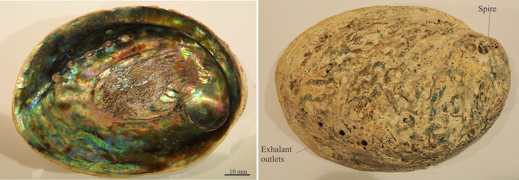
The common abalone Haliotis has virtually no spire but does have a very large body whorl and aperture – this is the part where a large foot attaches firmly to hard substrates, such that the animal can withstand significant wave pressure. It is also characterised by an intensely iridescent nacreous layer on the inside surface. It is called Paua (pronounced par wah) in New Zealand.
The body whorl of the involute gastropod Bulla completely envelops the earlier whorls. The body whorl extends the entire length of the shell.
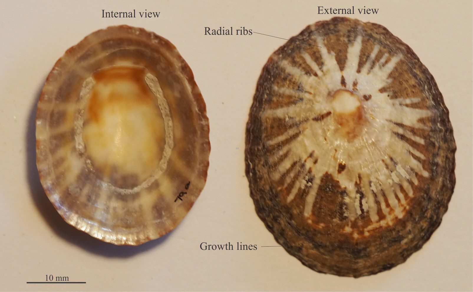
Common limpet shells like these Cellana are non-coiled. Like Haliotis, they attach to hard substrates and can withstand significant wave pressures – they like to live in wave-washed zones.
Other morphological elements
The primary morphological elements such as body whorl, spire, and aperture are described above. Additional attributes are shown here for four different species.
The spiny murex are some of the most spectacular marine snails. This fine example of Chicoreus ramosus contains many of the structural and ornamental attributes that are common to many other species. The spectacle of most murex shells lies in their ornamentation – arrays of spines, nodes, and spiral threads that extend around whorl circumferences. Many of these calcareous growths form at the intersections with growth lines – the growth lines in most gastropods extend the length of the shell (and not its circumference).
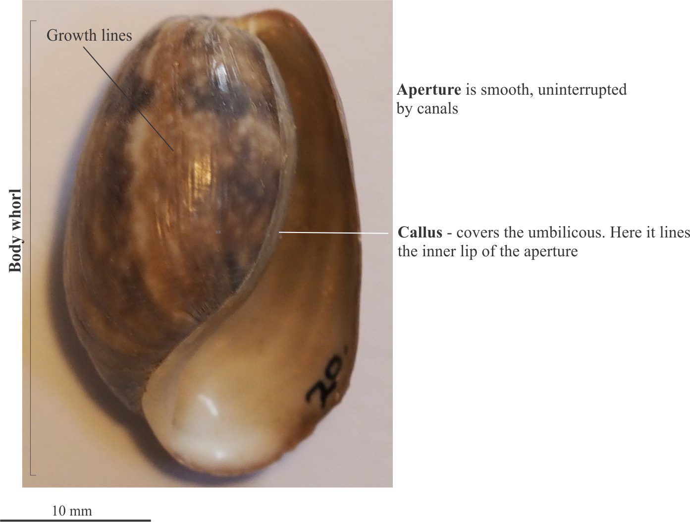
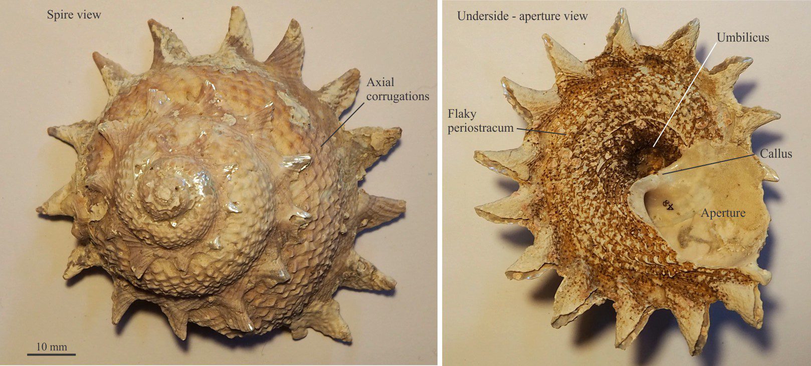
In the turbinate Cat’s Eye shell (Turbo) the body whorl is about the same height as the spire. The whorls are inflated – compare them to whorls in the turret shell shown above. The margins of the aperture are continuous, lacking interruptions by either siphonal or anal canals. The umbilicus is completely covered by a broad callus that extends from the inner lip of the aperture. Internally, the shell has a nacreous lining of aragonite. The operculum is a solid calcium carbonate disc (the cat’s eye) that has high preservation potential compared with the chitinous opercula in many gastropods.
The turbinid shell Cookia sulcata (NZ) that has a conical shape with a flattish base and large, solid spines evenly spaced around the sutures. Whorls are inflated. The umbilicus is almost completely open (partly covered by the callus). The brown covering seen on the underside is the periostracum, an organic layer secreted by the organism to help protect the shell from abrasion – it has low preservation potential.
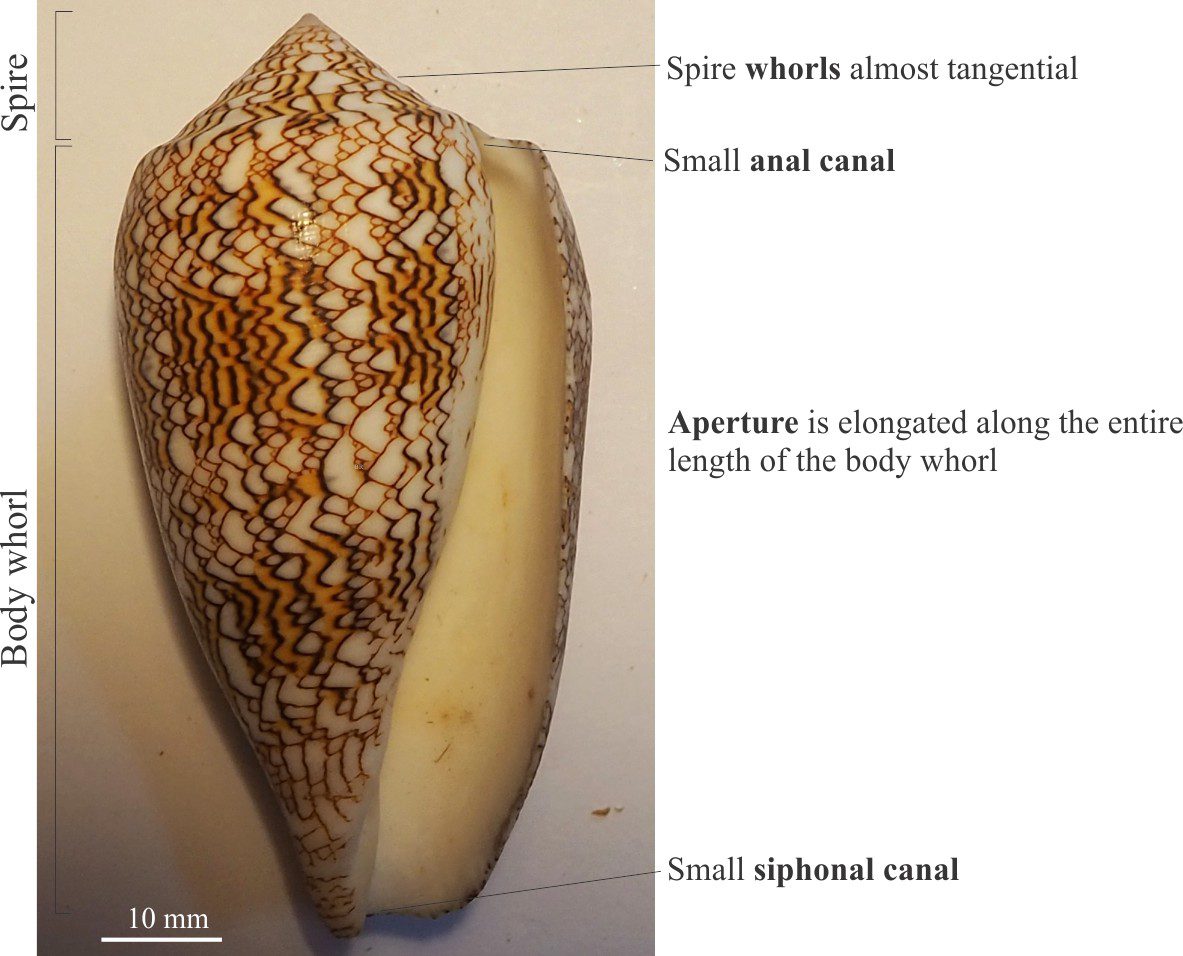
The elongate, relatively narrow aperture is typical of Cone shells and Cowries. The shell surface is smooth, lacking surface ornamentation. Unfortunately, shell colour is rarely a preservable property.
Green schist hypothetically ‘eroded’ and whittled progressively to finer grain sizes
The utility of lithic grains as provenance indicators
The composition of terrigenous sandstone is usually described in terms of the tripartite quartz-feldspar-lithic framework. The quartz and feldspar clast end-members are monomineralic. The lithic end-member takes care of all other grain types that are a mix of minerals such as quartz, feldspar, clay, heavy minerals, volcanic groundmass, and carbonate.
Notwithstanding the value of zircon systematics to unravel potential sources of clastic sediment, most sandstone provenance studies begin with an evaluation of the granular framework. Unfortunately, the value of the common rock-forming minerals quartz and feldspar as provenance indicators is frequently ambiguous – a grain of monocrystalline quartz may be derived from granitic, rhyolitic, or gneissic source rocks; and polycrystalline quartz from several kinds of metamorphic rock, recrystallized sedimentary chert, or tectonized quartz-rich rocks. In comparison, a decent lithic is worth its weight in gold.
However, there are a couple of limitations that influence the value of lithic fragments as source rock indicators:
The potential for diagenetic alteration of some components, particularly clay, feldspar, ferromagnesian minerals, and volcanic glass, and
Grain size will influence the identifiability of source rock composition, texture, fabric, and structural attributes. As a general rule, larger clast sizes will afford greater confidence in interpretation.
The exercise below shows how the identification and interpretation of lithic clasts can change according to:
The crystallinity or coarseness of the original source rock.
The final grain size of lithic fragments.
Green schist
The first example is a quartz-rich green schist (Fox Glacier, New Zealand):
Foliation is defined by biotite laths and elongation of quartz crystals.
Mica crystal orientations are parallel from one foliation to the next.
Quartz crystals have irregular, interlocking contacts.
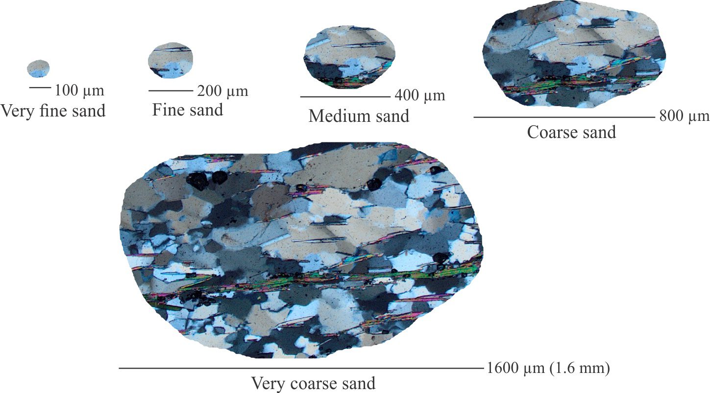
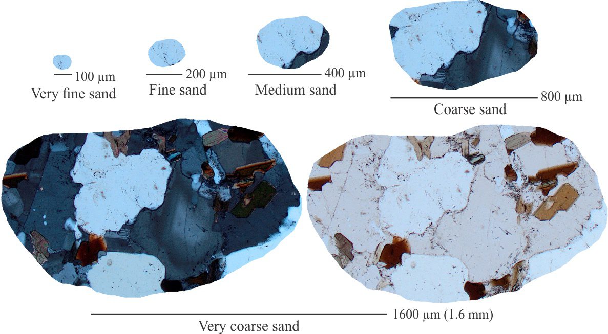
Quartz crystal size ranges from <100 μm to 600 μm (0.6 mm), corresponding to very fine through coarse sand size.
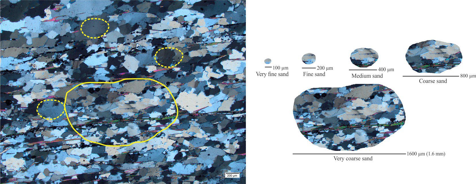
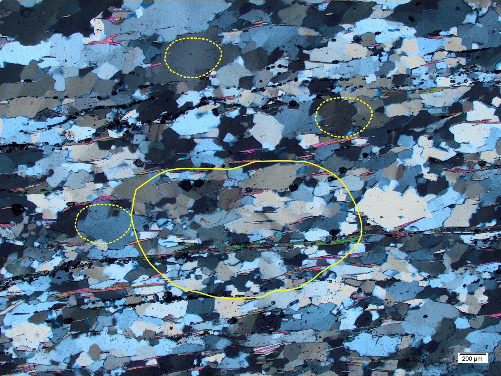
Wide-field view of a green schist (3.8 mm wide (3800 μm). The solid yellow outline corresponds to a hypothetical, very coarse sand-size clast. Dashed outlines correspond to medium sand-sized clasts. Crossed polars.
In the next image, hypothetical sand grains are ‘eroded’ from the green schist, beginning with the very coarse sand-sized fragment that, in turn, is whittled progressively to finer grain sizes (grain sizes are based on the Wentworth Scale).
Lithic fragments composed of green schist (a mix of quartz and biotite) at progressively finer grain sizes. Views are all crossed polars.
Very coarsetocoarse sand; The full complement of interlocking quartz grains, biotite laths and schistose foliation is recognizable in both grain sizes.
Medium sand; quartz aggregates would probably be counted as polycrystalline quartz rather than lithic grains. Biotite may persist in medium sand-sized grains but its orientation at this scale of observation may not reflect the larger-scale foliation. Furthermore, the identification of foliation in quartz is also ambiguous.
Fine to very fine sand; In this example, fine and very fine grain sizes have the same dimensions as many individual quartz crystals. In this case, quartz grains might be counted as monocrystalline or polycrystalline quartz rather than as lithics.
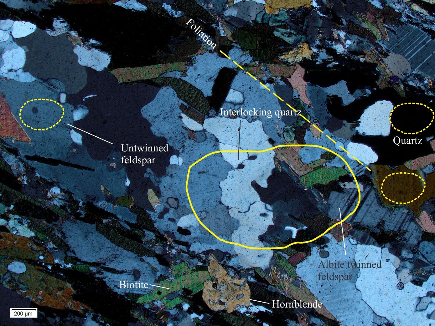
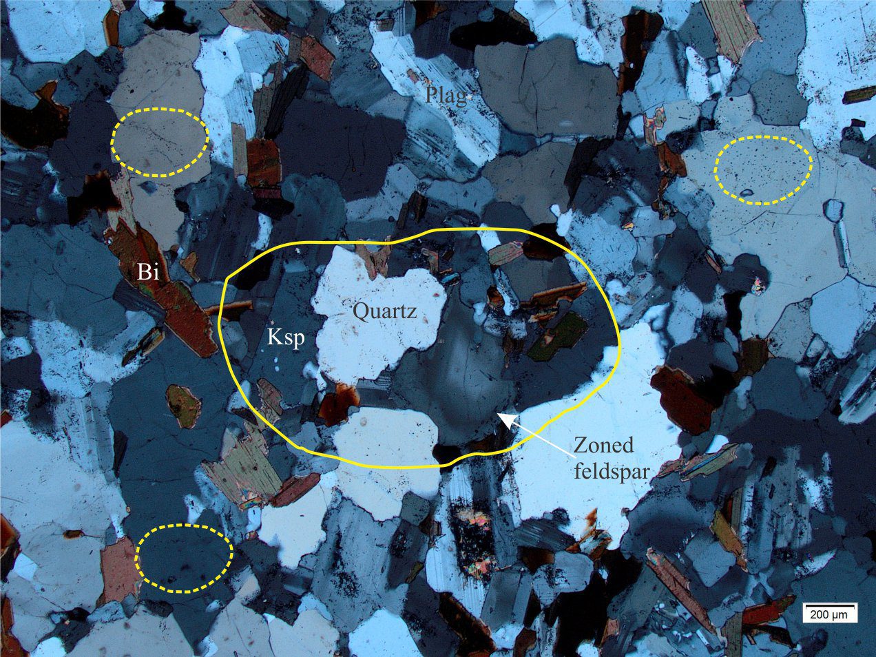
Biotite-hornblende gneiss
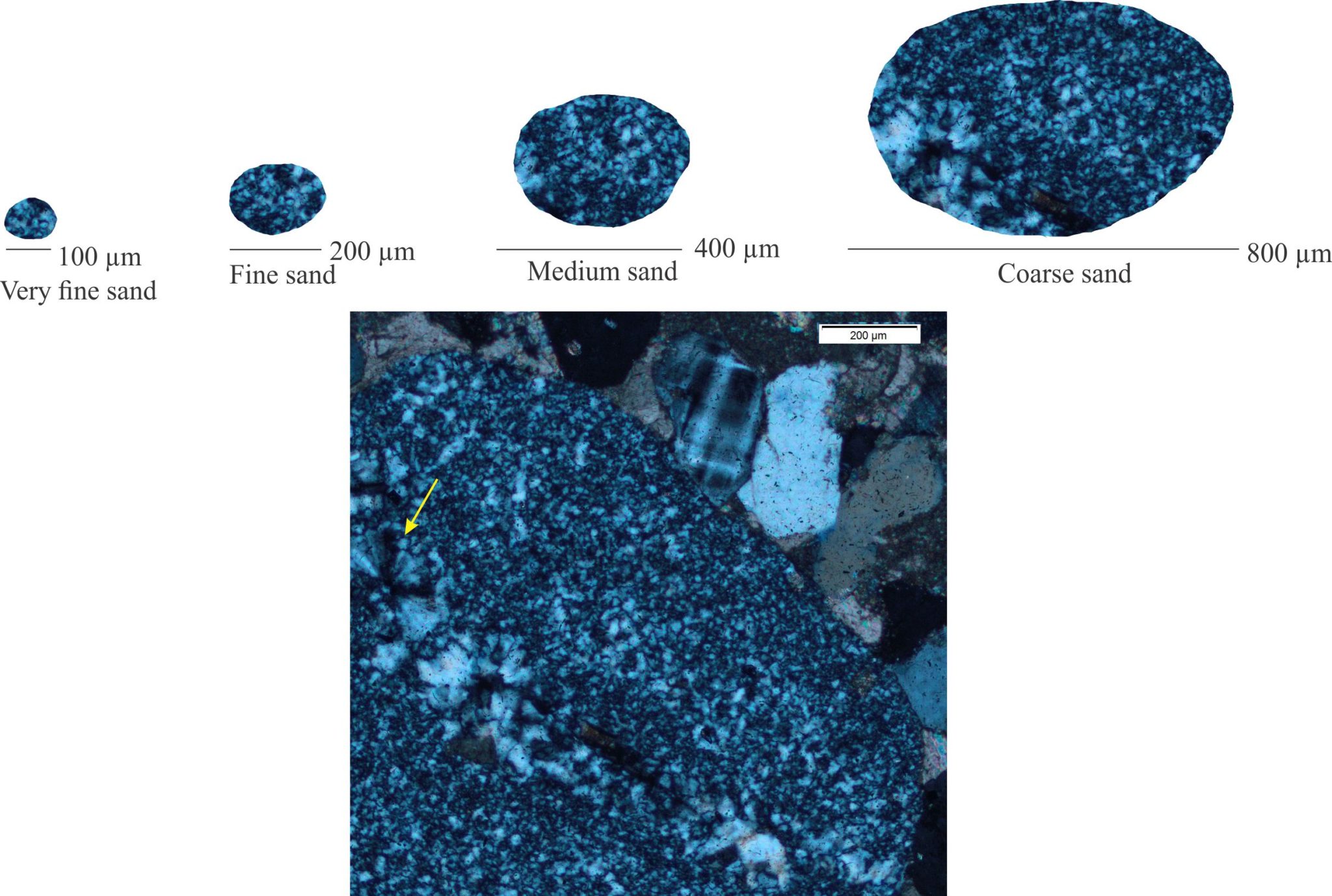
Biotite-hornblende gneiss. The solid yellow outline corresponds to very coarse sand-size; the dashed outlines correspond to medium sand. The straight dashed line parallels the foliation. Crossed polars.
Gneissic rocks tend to be more coarsely crystalline than schist. In this example and at this scale (field of view is 3.8 mm wide), the foliation is recognizable but less distinct than in the green schist shown above. Biotite crystals are larger than their green schist counterparts and oriented at more variable angles to the foliation.
Lithic fragments composed of biotite-hornblende gneiss at progressively fine grain size. Views of the very coarse sand grain are crossed polars on the left, plain polarized light on the right. All other grains are crossed polars.
Very coarse sand; This grain size captures large, untwinned feldspar, quartz, plagioclase (albite twinning), and a couple of biotite laths. However, the likelihood of capturing the gneissic foliation is low, even in very coarse-grained clasts.
Coarse-grained and finer sand; Foliation is not identifiable in these grains.Medium sized grains may capture crystal a boundary, but many would appear monomineralic and difficult to differentiate from other sedimentary, volcanic, and intrusive source rocks.
If grains at very coarse sand or larger are not available, then the distinction between this gneiss and possible granite, granodiorite, or reworked sedimentary source rocks will be ambiguous.
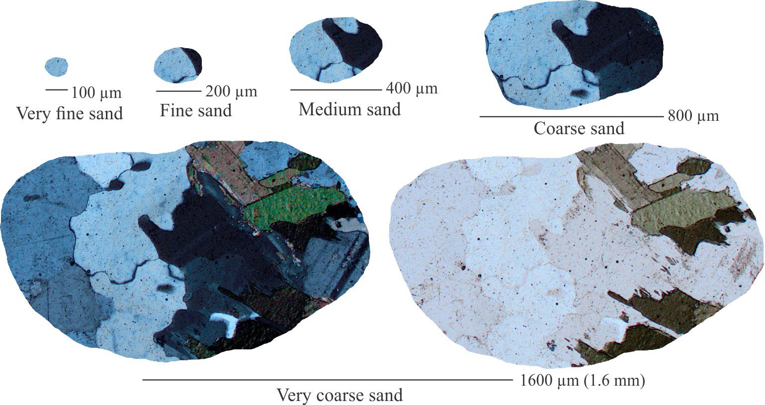
Biotite granite
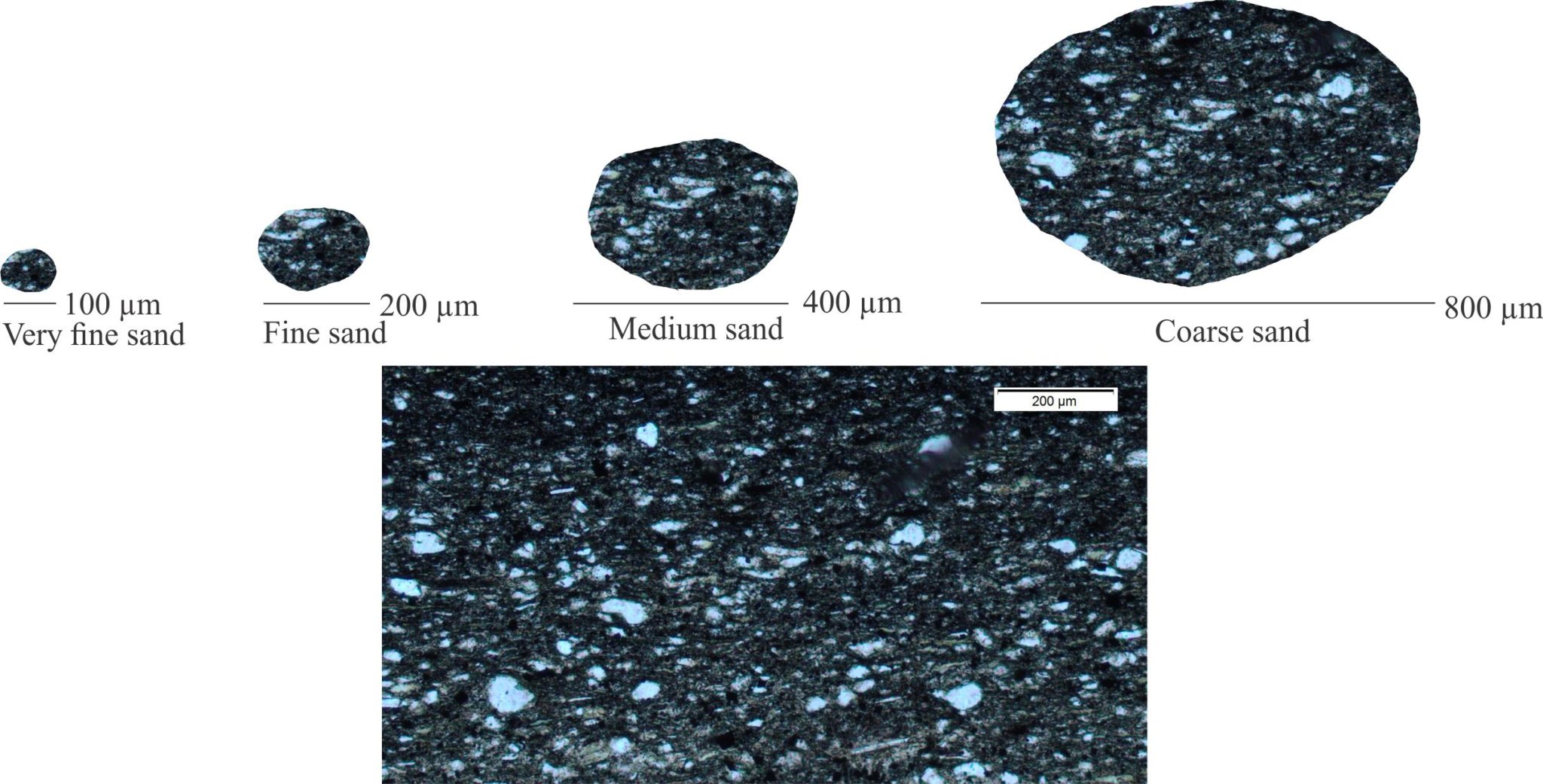
Biotite granite. The solid yellow outline corresponds to very coarse sand-size; the dashed outlines correspond to medium sand. Crossed polars.
The granite consists of untwinned potassium feldspar, quartz, plagioclase, and biotite. Crystal sizes range from 100 μm to more than 1500 μm (1.5 mm), averaging 400-600 μm. There is no foliation. There is little evidence of strain in the quartz crystals.
The following diagram shows the progressive change in grain size and identifiable features that would lead to an interpretation of granite source rock.
Lithic grains of granite composition at progressively fine grain size. Views of the very coarse sand grain are crossed polars on the left, plain polarized light on the right. All other grains are crossed polars.
Very coarse sand; Grains having this dimension have captured the essential feldspar-quartz-biotite aggregates. However, even at this grain size there may be difficulty distinguishing granite from some gneissic rocks, particularly if quartz shows any strained extinction.
Coarse sand; This grain size may capture single crystals of quartz, feldspar or ferromagnesian minerals, in which case they may not be distinguishable from gneiss, acid volcanic, or reworked coarse-grained arenites. This ambiguity will persist even if crystal aggregate boundaries are preserved.
Medium to very fine sand; Most grains will be counted as monomineralic. There will be little diagnostic information in these grains to distinguish them from many other source rock compositions.
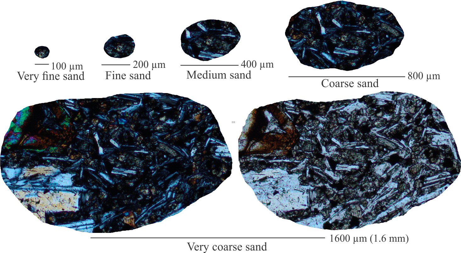
Olivine basalt
Olivine basalt, where olivine (Ol) and plagioclase (Plag) phenocrysts occur within an aphanitic groundmass. The solid yellow outline corresponds to very coarse sand-size; the dashed outlines correspond to medium sand. Crossed polars.
Like many basalts and andesites, this example contains centimetre-scale phenocrysts surrounded by a sea of very small plagioclase laths in much finer-grained groundmass (glass or altered glass). Volcanic textures like this are very distinctive and the corresponding lithic fragments are perhaps the most easily recognizable of all lithic types.
Olivine basalt lithics at progressively fine grain size. Views of the very coarse sand grain are crossed polars on the left, plain polarized light on the right. All other grains are crossed polars.
Sand-sized clasts consisting of volcanic material are some of the more easily recognizable lithic grains, particularly if they contain groundmass.
Very coarse to coarse sand; Phenocrysts may be captured in the coarsest size fraction, but commonly will tend to separate from the groundmass during weathering and erosion.
Coarse sand and finer; Volcanic groundmass is characteristically glassy or altered glass that is anisotropic under crossed polars. Groundmass commonly contains a mass of very small plagioclase crystals; crystals may show some alignment (a product of original flow banding). These fabrics are common in basaltic and andesites rocks, and serve to distinguish them from mudrock lithic grains, even at fine sand size.
Diagenetic alteration of the groundmass may render some lithics indistinguishable from siltstone – mudstone sourced lithic grains.
Recrystallized chert
Part of a chert granule in an arkosic arenite. The arrow indicates radial fabrics developed from recrystallization of chert. The long dimension of the grain is 1.5 mm. Crossed polars.
This example looks at the breakdown of an existing chert lithic clast. There is a diffuse band of partly recrystallized silica where the crystal size changes from <10 μm to about 100 μm (0.1 mm). Recrystallization has also produced some radial silica clusters (arrow).
The micro-cryptocrystalline textures of typical chert lithic grains are relatively easy to distinguish from other quartz aggregates
They are recognizable at grain sizes at least to fine sand.
Grains consisting of the coarser recrystallized silica might pass for polycrystalline quartz grains unless radial crystal aggregates are also present.
Incomplete recrystallization commonly produces patchy or clotted textures where patches of remnant microcrystals grade into coarser crystal aggregates, reminiscent of the structure grumeleuse in neomorphosed micrites.
Silty mudstone
Silty mudstone with recognizable fine to coarse silt-sized quartz, chlorite, carbonate, and feldspar cleavage fragments. There is a hint of (horizontal) lamination. The matrix is a mix of clays, carbonate, and iron oxides. The field of view is 1.2 mm wide. Plain polarized light.
There is a complete gradation from very fine framework clasts to matrix. This is recognizable in grains at least to medium sand size.
Textures in some fine-grained sedimentary lithics may resemble the groundmass of aphanitic volcanic rocks, particularly if the feldspar laths have been diagenetically altered in the latter.
Sedimentary layering in mudrock lithics must be distinguish from flow alignment of feldspars in aphanitic volcanic rocks.
Some generalizations
The confidence with which clastic sediment source rocks can be identified depends strongly on the crystallinity or coarseness of potential sources. As a general rule, the coarser the crystallinity, the larger the clasts needed to positively identify that source.
The above comment can be restated as – there is an optimum grain size where the whole-rock identity of a lithic fragment can be made. For example, the optimum clast size that captures the essential minerals and foliation for schist-type rocks will be smaller than that for coarser gneissic rocks. At progressively finer grain sizes the common rock-forming minerals (quartz, feldspar, various heavy minerals) tend to be presented as monomineralic grains rather than components of lithic grains.
The specific source rock identity of common monomineralic, and even some polycrystalline aggregates of quartz and feldspar is frequently ambiguous, making the distinction among granite-granodiorite, gneiss, volcanic phenocrysts, or recrystallized chert difficulty. There are a few exceptions, such as bipyramidal quartz that is restricted to rhyolite, dacite, and ignimbrite, or minerals like kyanite and sillimanite that are found in high-grade metamorphic rocks.
For provenance studies, choose the coarsest samples possible.
Supercritical and subcritical flow domains manifested as standing waves and ripples
19th century experiments that helped quantify the nature of fluid flow, surface waves, and bedforms.
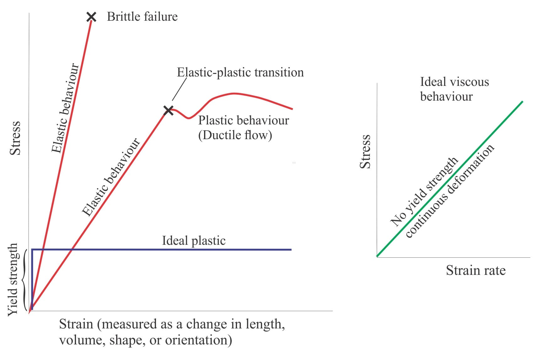
It all depends on inertia, like the reluctance to get out of bed on a cold winter’s morning. But rather than feeling guilty, acknowledge that by sleeping in you are adhering to the mechanical Laws that prevent the universe from collapsing – the inertial forces that keep planets in orbit around their suns, and suns in motion through their galaxies.
Inertia is loosely defined as a force that resists the change in motion of a body; here motion refers to a vector that describes velocity and direction, and ‘body’ refers to pretty well anything composed of matter, including a body of fluid. The term was coined by astronomer Johannes Kepler (17th century); his erstwhile colleague Galileo demonstrated its qualities by experimenting with balls rolling along sloping surfaces.
However, it was Isaac Newton who codified the properties of inertia in his three Laws of Motion – apparently Newton credits Galileo with the discovery. The 1st Law, also called the Law of Inertia, states that the motion of a body will not change unless an external force acts on it (i.e., to accelerate, decelerate, or change its direction). The 2nd Law quantifies the relationship between an external force F, mass (m) and acceleration (a) as F = ma. And the 3rd Law states that when an external force is applied, there will be an equal and opposite force that resists the change in motion, i.e., an inertial force – also called the Action-Reaction Law.
Inertial forces depend on the mass of a body – the larger the mass, the greater the force. In fact, the concept of mass itself is based on inertia.
Inertia and fluid flow
Inertial forces are central to the quantification of fluid mechanics. We have William Froude (1810-1879) and Osborne Reynolds (1842-1912) to thank for their eponymous numbers (Froude number and Reynolds number) that describe the characteristic states of flow. And because these numbers are dimensionless, they allow experiments with models (e.g., wind tunnels, sediment flumes) that can be scaled to real-world fluid flow phenomena. Scaling can be applied to almost anything related to fluid flow – from the motion of a boat through water, to quantifying the formation of sediment bedforms or sediment gravity flows from small-scale sediment flume experiments. The importance of Froude and Reynolds numbers cannot be overstated.
Froude number
Froude’s influential paper of 1861 was published by the Institute of Naval Architects (PDF available). Froude had surmised that, to predict the behaviour of a ship moving through water, he would need to experiment with much smaller versions of ships, or models, that could be scaled to the behaviour of much larger vessels. Thus, Froude’s number was derived from experiments with model boats, a few metres long.
The number expresses the characteristics of flow, including surface waves and bedforms, as the ratio between inertial forces and gravitational forces:
Fr = V/√(g.D)
Where V is bulk flow velocity (having dimensional units L.T-1) that reflects the dominant effect of inertia on surface flows, and the component √(g.D) where g is the gravitational constant (units of L.T-2), and D is water depth (units of L). The denominator represents the speed of a surface gravity wave relative to the bulk flow velocity (√(g.D) simplifies to units of velocity). Whether the surface wave is faster, slower or the same speed as the bulk flow will depend on its resistance to move, or its inertia. Fr is dimensionless.
The numerical value of Fr is used to define three conditions of flow. If Fr = 1 (numerator = denominator), then any surface wave will remain stationary – it will not move upstream or downstream. This condition occurs when both the velocities and water depth are at critical values. Not surprisingly, this condition is called critical flow. A common manifestation of critical flow is the formation of stationary waves (or standing waves) above and usually in phase with antidune bedforms (i.e., upper flow regime).
A plot of the experimentally determined stability fields for bedforms, as a function of grain size and flow velocity. The transitions from one field to another are abrupt or gradual as indicated. Modified from Ashley, 1990, Figure 1 with minor additions.
When Fr < 1, inertial forces dominate, and the result is a subcritical condition – tranquil flow. This corresponds to lower flow regime bedforms such as ripples and larger dune structures.
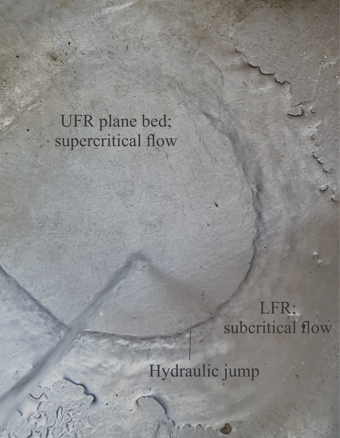
When Fr > 1, gravitational forces dominate resulting in supercritical flow conditions. The corresponding stream flow surface conditions manifest as an acceleration of flow such that stationary waves break upstream (chutes – upper flow regime), commonly followed by a rapid decrease in flow and formation of a hydraulic jump where Fr < 1 (chute and pool conditions). A hydraulic jump is the region of turbulence that represents the transition from supercritical (laminar) flow to tranquil flow – as shown in the kitchen sink example below. Supercritical flow is also common in pyroclastic density currents.
A kitchen sink demonstration of the transition from laminar, supercritical flow to turbulent subcritical flow via a hydraulic jump.
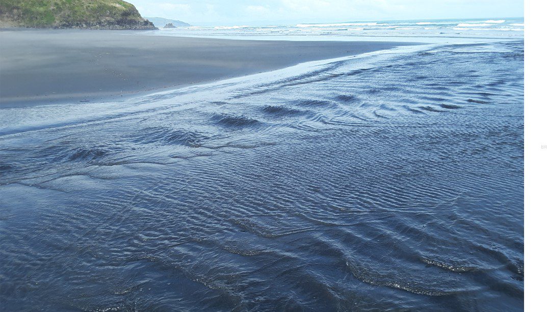
The complexity of flow transitions in a small natural system is shown in this video clip of supercritical and subcritical (tranquil) domains in a small, shallow stream. The standing waves (left) represent critical conditions where the speed of the waves matches the stream flow velocity. Supercritical conditions downstream produce chutes. Downstream migrating ripples in the foreground indicate subcritical flow.
Reynolds number
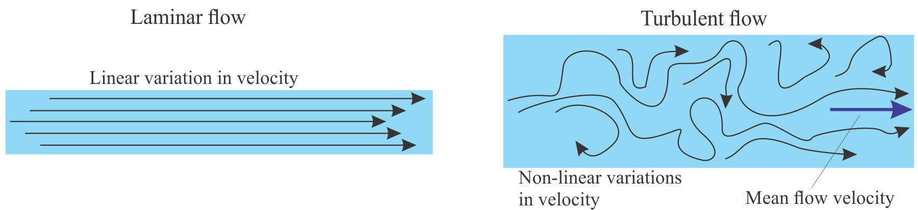
Schematic representation of laminar and turbulent flow using hypothetical flow lines. The blue arrow (right) indicates mean flow velocity for turbulent flow.
Unlike Froude who was more concerned with the surface configurations of a flowing medium, Reynolds experiments in glass pipes were concerned with the bulk structure of flow, in particular the transition from laminar to turbulent flow (Reynolds, 1883, PDF available). To picture this, think of a flowing fluid as a set of flow lines. In laminar flow, the flow lines are parallel, or approximately so, and relatively straight. The flow velocity will be the same across each flow line. By contrast, turbulence is described by flow lines that constantly change direction and velocity. In a flowing stream this is manifested as eddies, boils, and breaking waves. In sedimentary systems, turbulence is an erosive process, and an important mechanism for maintenance of sediment suspension through water columns and in sediment gravity flows.
The video below shows the abrupt transition from laminar flow in the slightly sinuous trail of smoke, to turbulent flow above.
To understand the nature of the laminar-turbulent flow transition, Reynolds considered four variables:
Fluid density ρ (units of M.L-3).
Fluid viscosity (μ) that measures the resistance to shear and is strongly temperature-dependent. μ has units of M.(L.T)-1
Mean velocity of flow V, that reflects shear rate and inertia forces (units of L.T-1), and
Tube diameter D that influences the degree of turbulence (units of L).
Reynold’s number is written as:
Re = ρVD/μ
that expresses the ratio of inertial (resistance) forces to viscous (resistance) forces. Re is dimensionless.
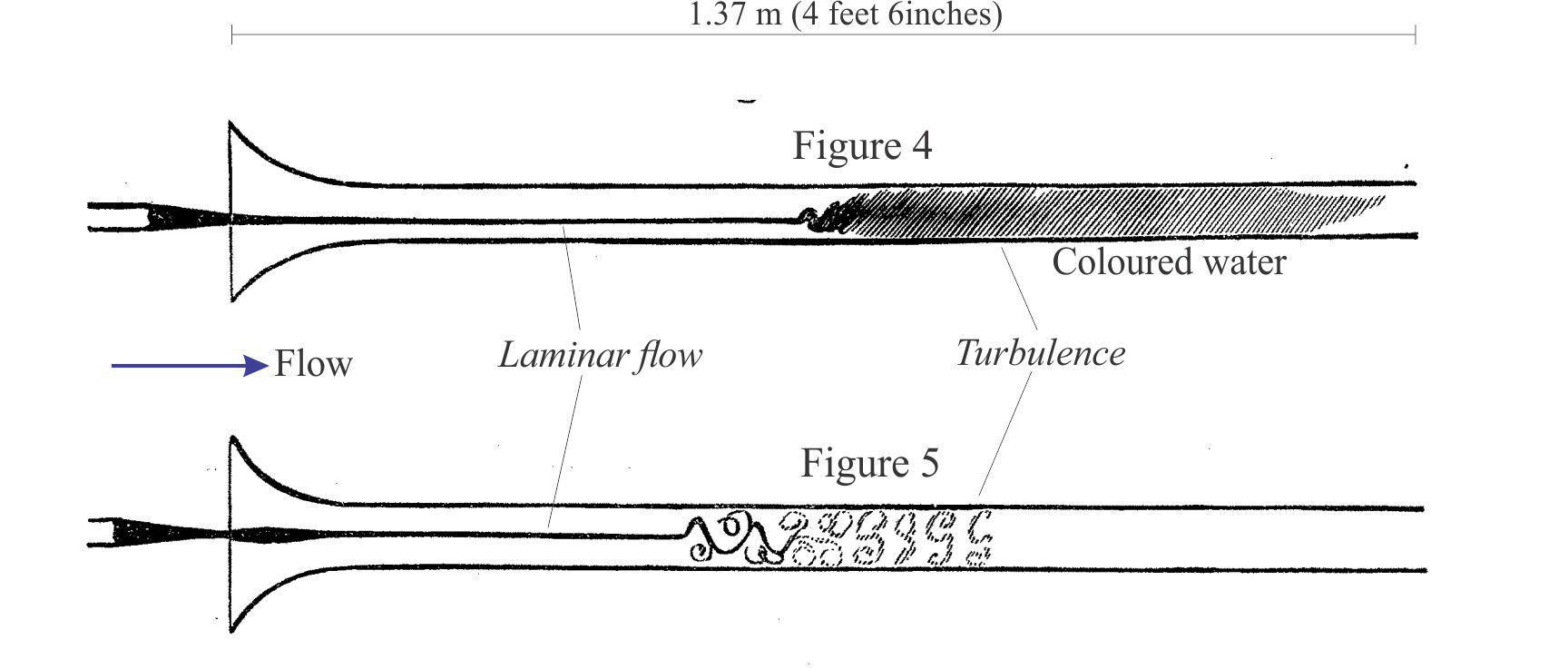
In his glass tube experiments, Reynolds systematically varied μ, V, and D (μ was varied by heating the water). For each combination he discovered that the transition from laminar to turbulent flow in water was abrupt, and consistently had Re values of about 12000. Reversing the experiment gave values of about 2000 for the transition from turbulent to laminar flow.
Reynolds’ original glassware used in his fluid flow experiments. Tube diameters ranged from 2.54 cm to 0.62 cm. Coloured dye was introduced through a funnel. In all experimental runs, the transition from laminar to turbulent flow was abrupt. These figures are from Reynolds’ 1863 paper.
Re can be used to determine the kind of flow in large and small fluid systems. As a general rule:
Re values <2000 indicate laminar flow,
Re >4000 turbulent flow, and
the region in between these two extremes reflects transitional flow.
Flow in most open-surface geological and geomorphic systems tends to be turbulent, with familiar examples including channelized flow (river, tidal and submarine channels) and more open flow across broad expanses such as continental shelves. It also includes volcaniclastic systems like pyroclastic flows and surges. Experimental flow in flumes produces a variety of bedforms at Re values that range from about 4000 to >100,000.
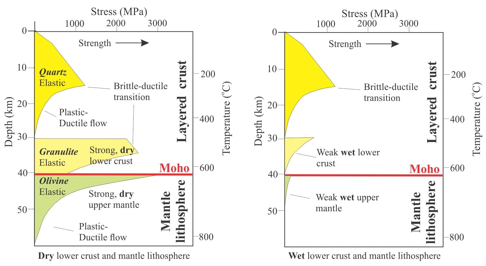
Laminar flow at low velocities is probably responsible for deposition of lower flow-regime plane beds; Allen (1992) has suggested that laminar flow at higher velocities may be restricted to thin sheet floods. Fluids having high viscosity, such as glacial ice and lava, commonly exhibit laminar flow. The Re value in microscopic rock-fluid systems, such as intercrystal boundaries in diagenetic environments, will also be low because fluid viscosity will dominate in such confined spaces.
Comparing Froude and Reynolds numbers
Froude numbers express a relationship between the free-surface of a flow and the various waves and ruffles that form there, and bedforms at the sediment-water interface. Reynolds numbers deal to the bulk characteristics of flow – whether it has laminar or turbulent structure.
The numbers Fr and Re are like chalk and cheese – they are not comparable. Both are dimensionless ratios, but that’s where the similarity ends. Both functions depend on inertial forces (the resistance to do anything), but for Fr the inertial component is in the denominator, and for Re in the numerator. Thus, if inertial forces become dominant, the numerical value of Fr decreases and that for Re increases.
Both numbers have application well beyond the relatively narrow field of sedimentology. Both are used extensively in scaled models – Fr for elucidating the efficacy of movement through a fluid – boats through water, airplanes through air. Re is used extensively to describe fluid flow in biological systems.
Allen (1992) has given sedimentologists a diagram that generalizes the relationship between Fr and Re in terms of mean flow velocity and flow depth. The boundaries of the 4 domains correspond to critical flow transitions; subcritical (tranquil) to supercritical for Fr, and laminar to turbulent for Re. I have added the most common bedforms to these domains.
J.R.L. Allen’s (modified slightly from 1992, Fig. 1.21) plot showing four domains of fluid flow, the boundaries of which are defined by the laminar-turbulent flow transition (Reynolds), and the subcritical-supercritical flow transition (Froude).
Literature
There are many publications on this topic, but I highly recommend two publications that provide greater detail of theory and practice on this and other topics in fluid flow and sedimentation:
John Southard’s excellent (open access), online Introduction to Fluid Motion and Sediment Transport.
J.R.L. Allen 1992 (and later editions) Principles of Physical Sedimentology (that no sedimentologist should be without).
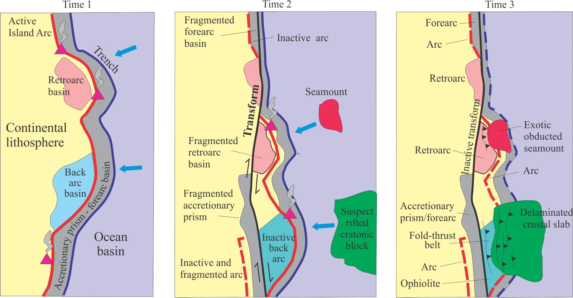
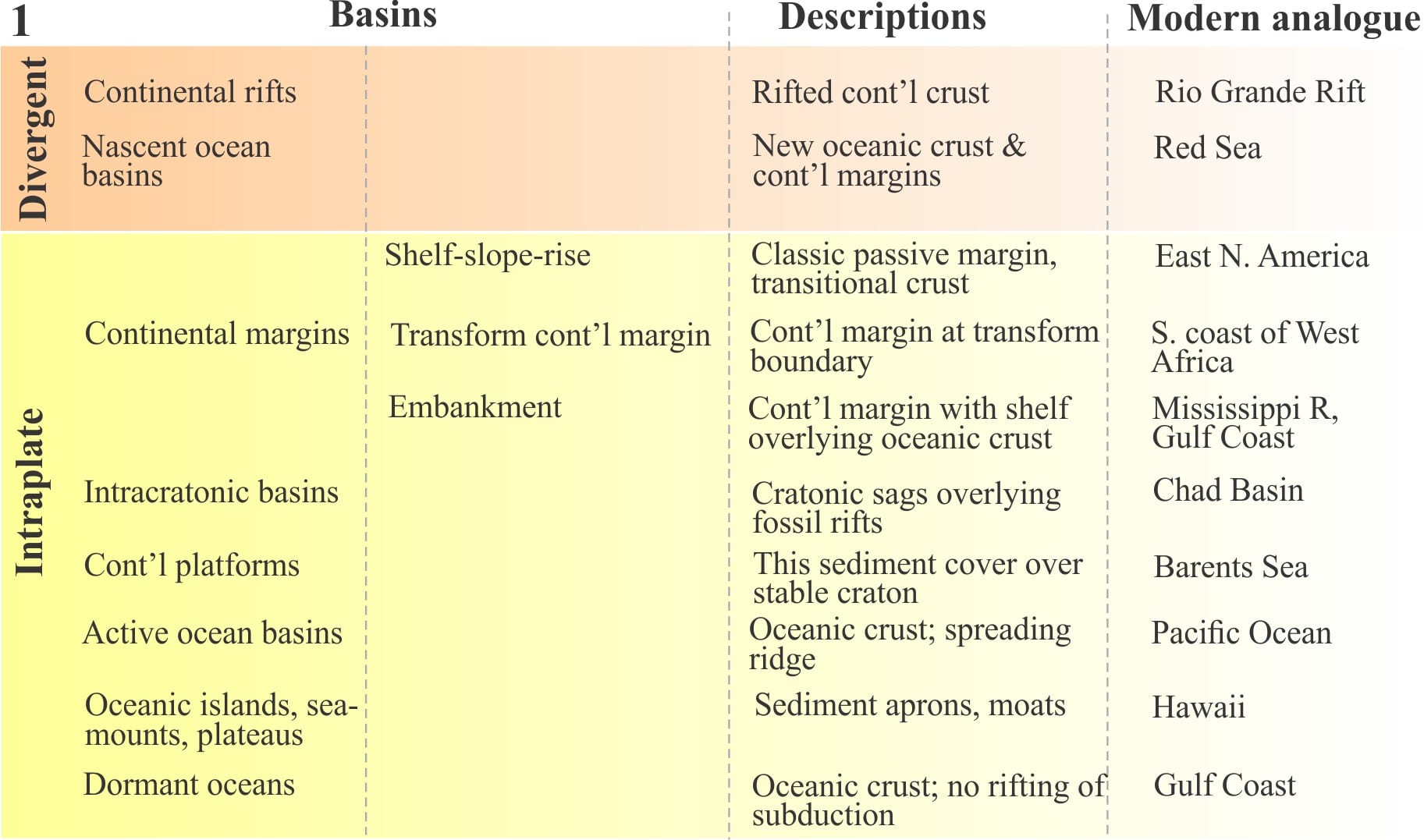
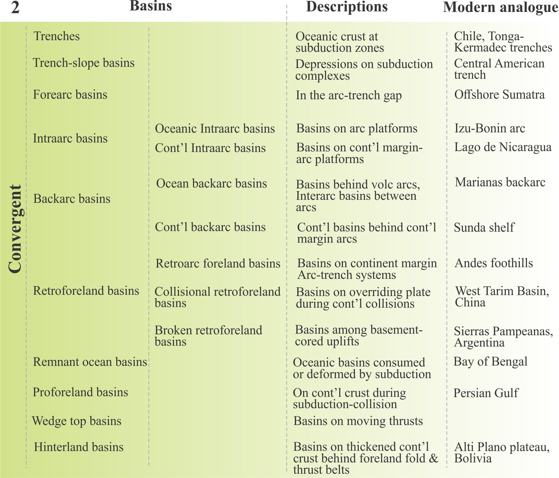
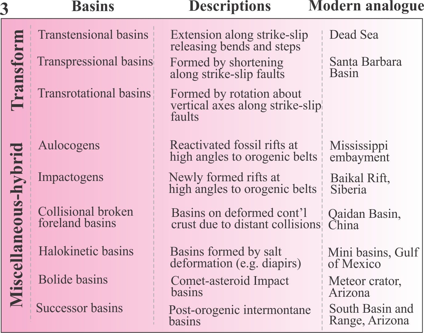
A hypothetical collegiate of terranes across an orogen, transported by strike-slip dislocation, subduction, and obduction. Distances traveled are measured in 100s of kilometres. Modified quite a bit from Helwig, 1974, Fig.1.
In 1972 James Helwig introduced the concept of orogenic collage, wherein orogenic belts were representative not of a unified series of tectonic events, but are a collection of disparate terranes that are structurally discordant one with the other (Helwig, 1974). Each terrane is stratigraphically and structurally distinct from its neighbours. Each terrane has a distinct geological history that precedes its amalgamation to other terranes, but linkages to other terranes are established by crustal- and lithosphere-scale plate tectonic processes, principally subduction, obduction, and strike-slip transform displacement. Thus, terranes have pre- and post-accretion histories. The associated sedimentary basins provide the geological history of all these events.
The twin concepts of orogenic collages and allochthonous terranes are central to our present understanding of mountain building. Many of the important concepts and terminology were established in the 1970s and 80s – most have stood the test of time and scientific critique (Monger et al., 1972; Coney et al., 1980; Jones et al., 1983; Coney, 1989.
The following notes describe the main criteria for identifying terranes, the timing of terrane accretion (to other terranes or stable craton), from whence they came, and how far they have traveled.
Because of their oddness, terranes (not terrains) are often referred to as exotic or suspect. All of them are allochthonous, some having traveled many 1000s of kilometres. The term tectonostratigraphic terrane refers to their unique stratigraphic and structural histories.
Terranes may be complete lithospheric entities, or slivers of crust scraped off or delaminated during accretion. Accretionary prisms are good examples of the latter, where the upper portion of oceanic crust is scraped off during subduction (the remainder goes down the subduction zone).
Terrane candidates include rifted continents, fragments of oceanic crust (including seamounts and oceanic plateaus), and island arcs. Ophiolites are, perhaps, the quintessential discordant terrane – long recognised in the European Alps (pre-plate tectonics) as ‘odd rocks’ – assemblages of ultramafic rocks, sheeted dykes, basaltic pillow lava, ribbon chert and pelagic shale, tectonically juxtaposed against shallow water miogeoclinal successions. By the early 1970s it was generally agreed that ophiolites were remnants of oceanic crust, and in many cases were the only evidence of former ocean basins.
Amalgamation, or docking of a terrane to autochthonous cratons or other terranes involves accretion via plate convergence or strike-slip displacement. Plate convergence inevitably involves spreading and subduction of oceanic lithosphere.
Two or more terranes may dock en route to their destination. These amalgamations are called composite or superterranes.
Sedimentary basins: Inboard basins are those on the leading edge of an advancing terrane; the basins may overly the terrane, be a part of an intervening ocean, or configured as forearc or foreland basins (the latter tied to fold-thrust belts that form during plate convergence). Terrane displacement by strike-slip faulting may produce inboard pull-apart basins. Outboard basins are located on the trailing edge of a terrane. Inboard basins will potentially provide most of the relevant information on the timing of docking and its associated deformation.
Criteria for terrane identification
Terranes are invariably bound by faults or zones of deformation. Deformation during docking will affect both the incoming terrane and the autochthon, and potentially crosscut or overprint pre-existing structural fabrics.
They tend to have stratigraphy, structure, and radiometric ages that are incompatible with other terranes or the autochthon.
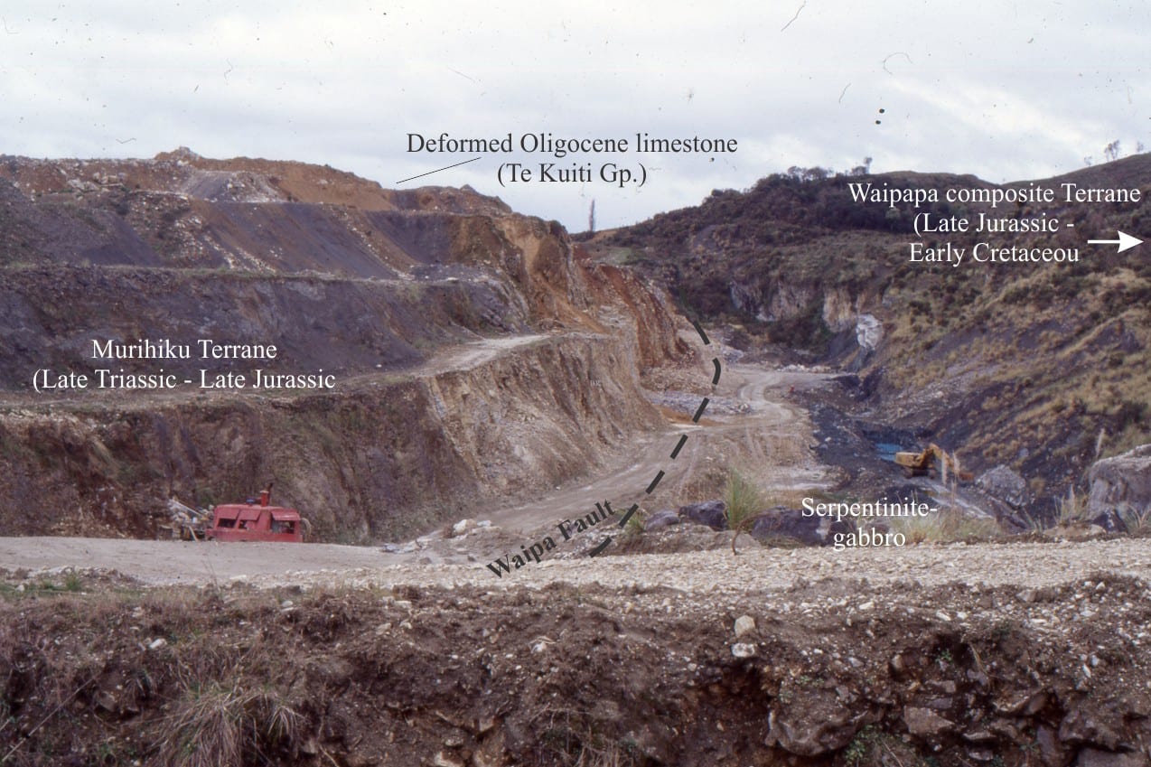
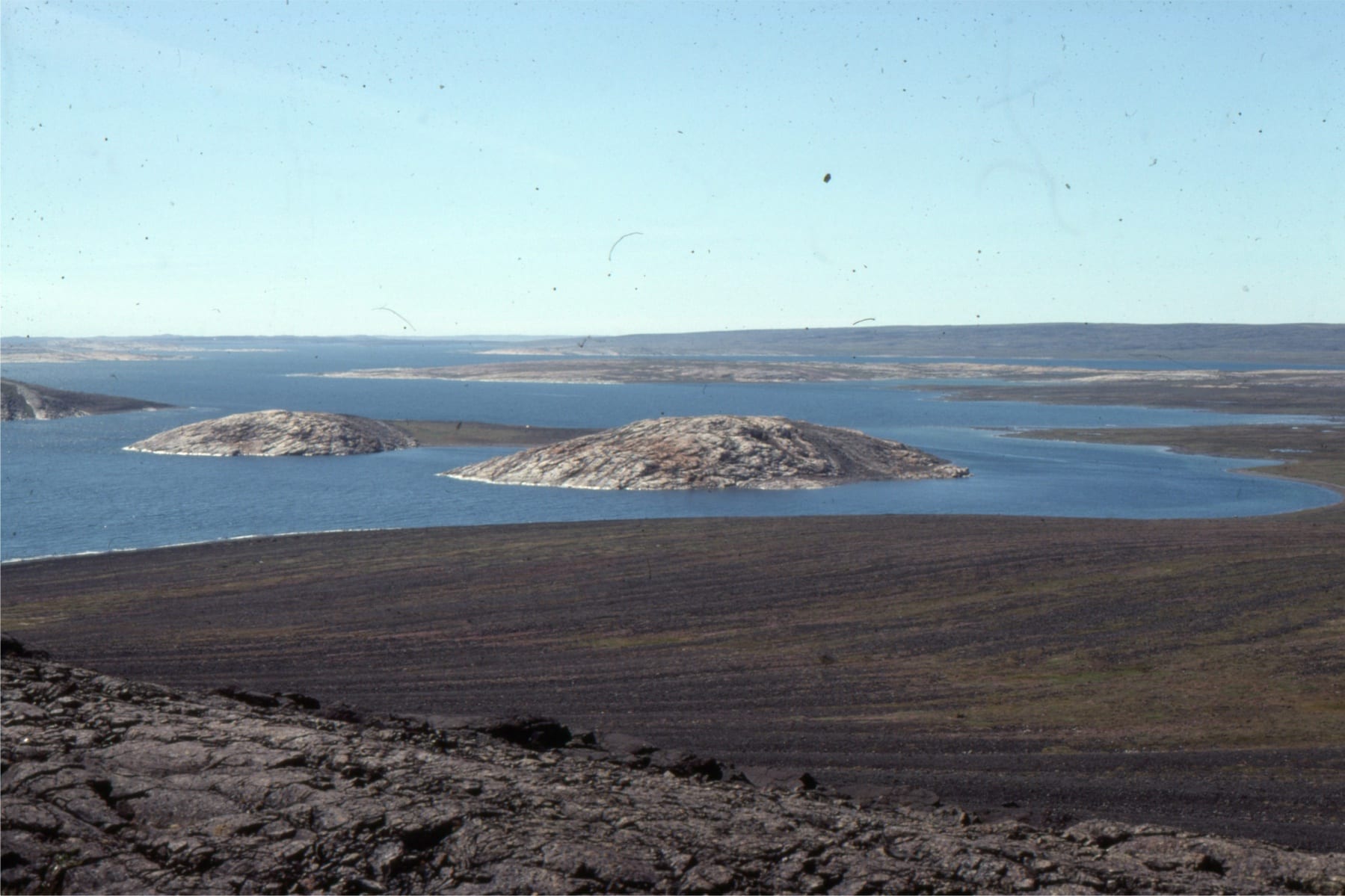
A terrane boundary, central North Island (New Zealand) marked by intrusion of subcrustal – upper mantle serpentinite (exposed in the quarry excavation), was originally harzburgite, and part of the Dun Mountain ophiolite Terrane, that separates intensely deformed Waipapa Terrane accretionary prism greywackes (right) from weakly deformed Murihiku Terrane sandstone and shale. Here, the Dun Mountain Terrane is wafer-thin.
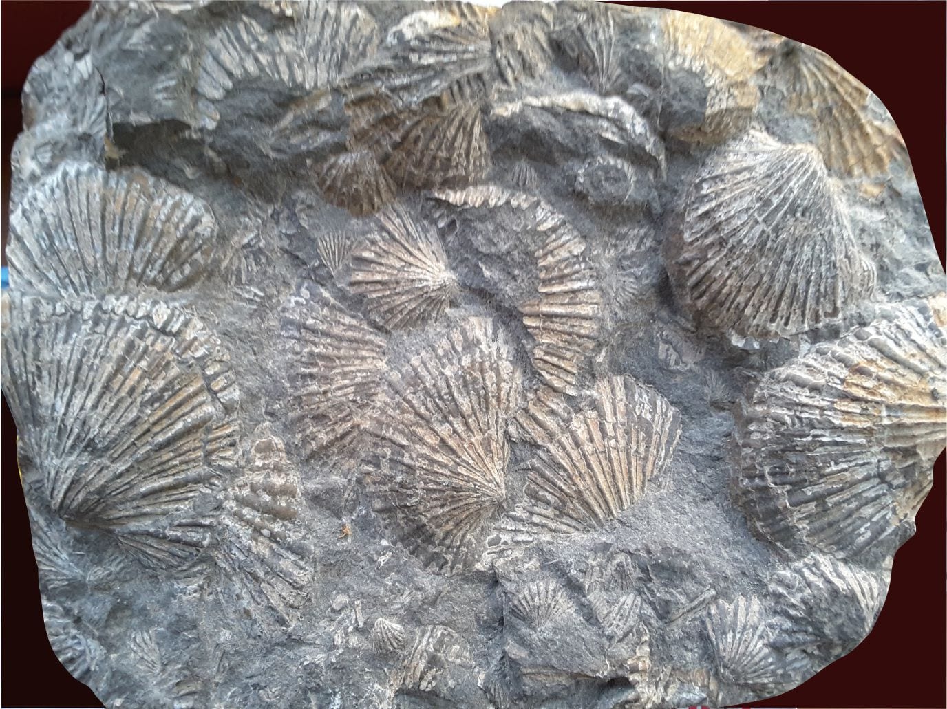
Assemblages of fossils may be incompatible with those in the autochthon. For example, the cosmopolitan bivalve Monotis, distributed globally but restricted to the latest Triassic, is found in autochthonous strata (North American continent) as far north as Nevada, but about 1000 km farther north in west coast British Columbia and Alaskan terranes (Tozer et al. 1991).
Monotis, a late Triassic, cosmopolitan index fossil (specimen is from Kiritehere, New Zealand). The distribution of faunas like this are particularly valuable for pin-pointing terrane displacement. The large valve on the left is 90 mm wide.
Radiometric dates of stable sedimentary grains such as zoned zircon commonly span a range of ages that represent the original magmatism plus later events such as metamorphism, uplift, and sedimentary reworking. Suites of ages from a terrane will commonly mismatch those from adjacent terranes or the autochthon (Gehrels, 2014). For example, if sedimentary zircons lack Precambrian ages, then it is unlikely that they were derived from basement rocks in an adjoining craton.
There may be a mismatch between the paleomagnetic poles measured in volcanic and fine-grained sedimentary rocks from a terrane, compared with the paleopoles determined for similar aged rocks elsewhere. The discrepancies provide a means of calculating possible distances of terrane dislocation and/or rotation.
Timing of terrane docking
Establishing the timing of terrane docking is one of the more difficult tasks. If the approach of a terrane (lithospheric or crustal block), is orthogonal the docking can be viewed as an event with a relatively narrow time span. However, if terrane approach is oblique then docking is diachronous and protracted. Criteria that help constrain the age limits are:
Pluton stitching; magmatic intrusions that extend across a terrane fault boundary provide upper age limits for accretion.
Overlap assemblages; terrain uplifted during accretion will shed sediment across the terrane boundary. In this case, unroofing and sedimentation will signal the end (or close to it) of the deformation associated with terrane accretion. The downside to overlap assemblages is that they also cover the terrane boundary. The term successor basin (Eisbacher, 1974; Ingersoll, 2012) is, for all practical purposes, synonymous.
Establishing the beginning of terrane docking is more difficult. There may be clues in preserved inboard sedimentary basins. For example, forearc basins, or basins that overlie the inboard margin of terranes may experience an influx of sediment, changes in sediment composition resulting from uplift, or unroofing that exposes deeper levels of existing sediment sources. There may also be changes in the locus of sediment dispersal in these basins.
The above criteria are pretty broad-brush; they also rely on dating the changes in basin dynamics. Zircon geochronology can assist here, where the upper age limit in a suite of (sedimentary) zircon dates may be close to or herald a docking event.
The Canadian Cordillera
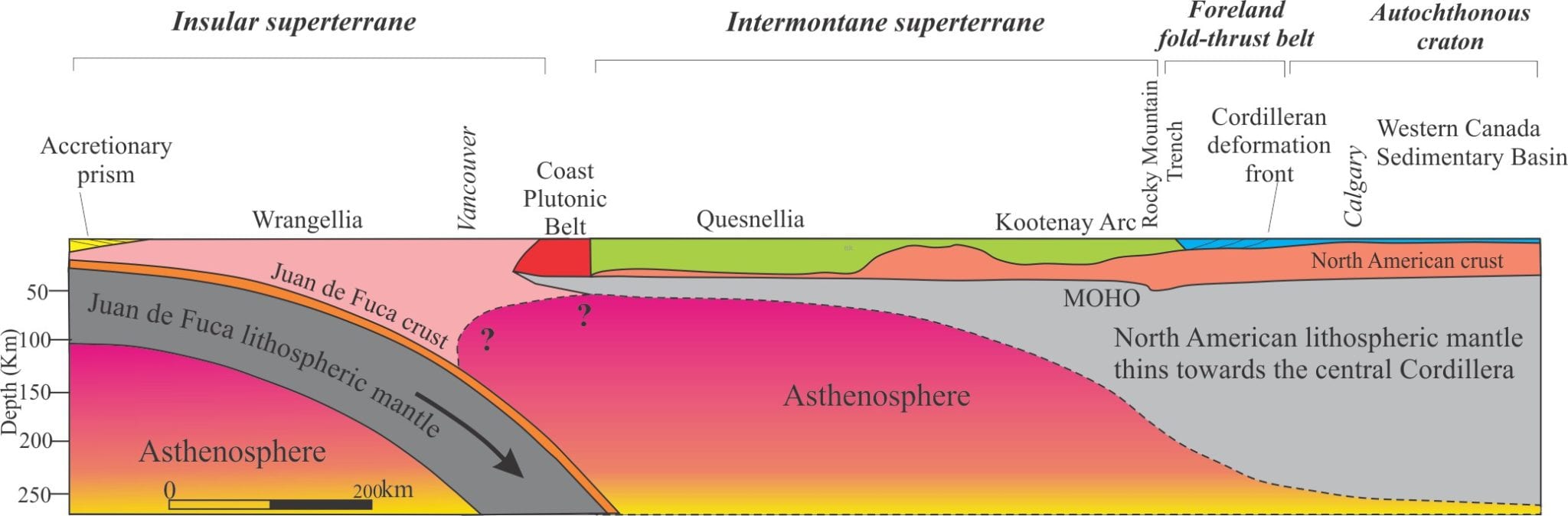
The western North American Cordilleran orogen is a collage of more than 200 terranes and superterranes (Monger, 1989; Ingersoll, 2019), ranging from large lithospheric blocks to skinny slivers of delaminated crust. Decades of regional mapping in the Canadian sector indicates that the Cordilleran margin has grown westward many 100s of kilometres from the edge of the stable craton, the product of terrane accretion over the last 180-200 million years. Most of the terranes and associated sedimentary basins are contained in two superterranes; Intermontane and Insular superterranes. [In addition to the references cited above, see Ricketts 2019 for a general synthesis of Cordilleran basins].
Interpreted LITHOPROBE data for the southern Canadian Cordillera transect, showing crustal and lithosphere-scale structure from the Juan de Fuca subduction zone (west) to the Alberta foreland fold-thrust belt and stable North American craton. The lithosphere mantle appears to thin drastically towards the western margin. Modified from Ricketts, 2019, who modified it from Cook et al., 2012, Geological Assoc. Of Canada, Special Paper 49, Chapter 1.
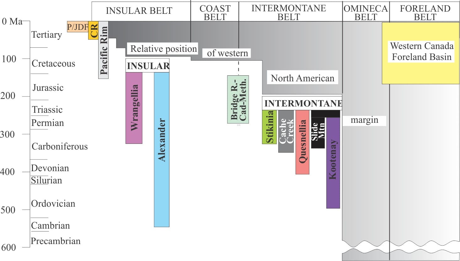
The Intermontane composite terrane contains 5 major terranes. The timing of their accretion into a single superterrane and its subsequent docking with North America is still debated, but it generally spans the period Early to Middle Jurassic. Farther east, this event records the beginning of the Western Canada Fold-Thrust belt and a significant pulse of sediment (the Kootenay-Fernie clastic wedge) shed to the adjacent foreland basin .
Time-space relationships among terranes, and Intermontane and Insular superterranes of western Canada, and their accretion to the North American margin. From Monger, 1989 (link given above). See also Ricketts 2019 for terrane and basin descriptions.
Insular superterrane consists almost entirely of two large terranes, Alexander and Wrangellia, that were amalgamated prior to docking with the western margin of Intermontane superterrane during the middle Cretaceous. The effects of superterrane docking were manifested farther east as renewed folding and thrusting, and development of the Blairmore (mid Cretaceous) and Belly River-Paskapoo (Late Cretaceous) clastic wedges in the Western Canada foreland basin (Stockmal et al, 1992; see the synthesis by Miall and Catuneanu, 2019). The linkages between Western Canada fold-thrust belt and superterrane docking are a good indication of the magnitude and extent of strain partitioning during terrane accretion.
‘Baja BC’
That the western Cordillera is a college of disparate terranes is no longer debated. However, the issue of whence the terranes came and how far they traveled is very much up for discussion. There is no better illustration of the disparity among competing hypotheses relating to terrane trajectory than the Baja BC debate, that concerns the origins of Insular and Intermontane superterranes; see Butler et al., 2001 (PDF); Gabrielse et al., 2006 (PDF); and Hildebrand, 2015 (PDF), for good reviews.
One school of thought posits travel from as far away as Mexico (4000 km), whereas another group of hypotheses contends distances were less than 1000 km. The debate hinges on paleomagnetic, paleontological and zircon geochronology data sets that not only conflict with each other, but in some cases are contradictory within their own data group. Some examples include:
Comparable, low latitude Permian fusulinids and Triassic coral faunas on the craton and terranes indicate large separations. However, mid- to high-latitude, upper Mesozoic radiolaria and molluscan faunas indicate minimal northward superterrane displacement.
Paleomagnetic data for Baja BC indicate about 3000 km northward displacement, but corrections for structural tilting of crustal blocks reduces these distances to less than 1000 km.
Zircon ages of possible source rocks for sedimentary basins on Insular superterrane have on the one hand been interpreted as locally derived, and on the other derived from source rocks in north Mexico, supporting the far-traveled school.
Despite nearly 5 decades of examination and re-examination, disagreement persists and a consensual hypothesis remains elusive.
Glossary of sequence stratigraphy, stratigraphic terminology, stratigraphic concepts and philosophy, and depositional systems.
A/S ratio (Accommodation/supply): The ratio between the rate of change of accommodation and sediment supply rate. The concept recognises that the expected change in accommodation with relative sea level rise or fall can be offset by sediment supply. For example during rising sea level, high rates of sediment supply can produce progradation instead of retrogradation during transgression.
Absolute age: A term that should be abandoned. There are no absolute ages in geology, only relative ages or radiometric ages. Radiometric ages depend on isotope half life and blocking temperature; any measured age has errors.
Accommodation: In depositional systems, it is broadly defined as the space available for sediment to potentially fill. It is usually referenced to baselevel that in marine systems is sea level. This definition does not imply the mechanisms that create accommodation space. Accommodation space can increase during relative sea level rise or decrease during sea level fall. Such changes are caused by allogenic and autogenic processes. The concept of accommodation has evolved into one that also incorporates sediment supply.
Actualistic models: Models based on the principle that natural processes and laws we witness today have acted in the past. This does not mean that the products of such processes, for example some environmental condition, will be the same today and in the distant past, but that the laws governing such processes will be the same. cf. Uniformitarianism
Aggradation: The vertical accretion of strata when sediment supply greatly exceeds the generation of accommodation either at the beginning or end of sea level rise. In a sequence stratigraphic context, it occurs during normal regression. The shoreline trajectory has a significant vertical component.
Allogenic processes: (allocyclic processes). Control of stratigraphic architectures and sea level by processes acting outside a depositional system. Typically, this includes regional subsidence, tectonics in sediment source areas (e.g. mountain building and erosion), climate, and glacio-eustatic sea level fluctuations. Cf. Autogenic
Angular unconformity: A stratigraphic surface that separates two bodies of strata having different orientations, the underlying rocks being much older than those overlying. Iconic examples are Hutton’s unconformities at Lochranza and Siccar Point that record long hiatuses between periods of deposition and mountain building. Cf. disconformity.
Anthropogenic: Processes and products produced by human activity that impact natural conditions and environments. There is frequently an emphasis on negative impacts, such as environmental degradation, loss of biodiversity, reduction of the gene-pool, and pollutants.
Antoine Lavoisier: (1743-1794) published one of the first explanations of transgression and regression, and the relationship of grain size in marine environments that would later become important for the development of facies concepts.
Arctic circle: Currently at latitude 66°33′46.9″N, it is the southern limit of continuous 24 hour daylight (summer) or night (winter) – actually measured to the centre of the Sun. It is moving north at about 15m/year because the earth’s tilt moves about 3o over a 41,000 year cycle known as Obliquity. There is an corresponding polar circle in the southern hemisphere.
Baselevel: It is an imaginary or theoretical plane to which geological, geomorphic and geodetic measurements are referenced. The commonly accepted datum is sea level, although it is also recognized that this too changes with time. The choice is based on common sense and a recognition that shorelines are a natural boundary between marine and nonmarine realms. Other baselevels may be useful depending on the problem being investigated, for example the margin of endorheic lakes, or some arbitrary position on a deep-water submarine fan.
Baselevel model: One of the principle models in sequence stratigraphy that relates, in a theoretical way, regression and transgression (retrogradation) in relation to changing baselevels (usually sea level). The model is based on identification of sedimentary, chemical, and biofacies, stratigraphic trends, theoretical considerations, and numerical modelling.
Biostratigraphy: The chronological ordering of strata based superposition of strata and the observed stratigraphic variations in fossils and fossil assemblages. The principle of faunal succession is based primarily on the appearance of specific organisms in certain strata that, in progressively younger rocks (deemed younger because they occur higher in the stratal succession), evolve into different, but related organisms.
Catastrophism: The principle that interpreted Earth landscapes and processes as the product of catastrophies. It had its origin in the Biblical Noachian deluge, and garnered support from events like volcanic eruptions and earthquakes. It was also compatible with Bishop Ussher’s estimate of age for the Earth computed from Biblical genealogy at about 6000 years. The principle was stood on its head in the late 18th century by James Hutton’sprinciple of Uniformity, later reinforced by Charles Lyell.
Celestial pole: An imaginary line drawn along Earth’s axis of rotation to the Pole Star, Polaris. Because Polaris is very close to this axis, it appears to be stationary in the night sky, whereas all other stars appear to move from east to west. However, even this pole moves slowly with precession of the equinoxes, completing a complete cycle about every 25,000 years. Cf. geographic pole, magnetic pole.
Chronostratigraphy: The part of stratigraphy that evaluates time relationships of rock units, whether as relative time like that determined from fossils or observing stratigraphic succession, or from numerical values of time measured by geochronology.
Clinoform: John Rich (1951) originally defined clinoforms as the depositional surface from wave base to the base of slope, including a shoreward undaform and a deep water fondoform. The latter two terms have been discarded. Clinoforms are now defined as the sinusoidal, chronostratigraphic surface extending from a shoreline across the adjacent shelf or platform to the slope and deep basin beyond. Clinoforms are important components of modern stratigraphic sequences.
Clints: Fracture networks in limestones formed by surface (meteoric) dissolution. They are common karst landscapes and occur sympathetically with grykes.
Concordia plot: For the U-Pb system, the curve plots the expected (theoretical) age against the three Pb/U ratios for the two U-Pb decay systems, assuming an ideal closed system (i.e. no loss of any isotope during a crystal’s lifetime). Measured isotope ratios for any crystal or batch of crystals are then compared with this ideal curve; if the age from each decay system is the same and they lie on the curve, i.e. they are concordant, then that is the true age of the sample. Discordant ages usually plot below the concordia. In this case, if the line segment (a discordia) connecting two or more discordant ages intersects the concordia, then the upper age intersection is taken as the maximum age of the samples.
Condensed section: (Stratigraphic condensation). Basically, very thin stratigraphic units that represent long periods of slow and non-deposition. They are characterised by: one or more biozone (depending on duration – 105 to 107 years); contain internal, non-depositional or erosional discordances, including omission surfaces; abundant authigenic minerals like carbonate, phosphate, chert, glauconite); commonly have hardgrounds or nodules of carbonate, phosphate, iron-manganese.
Correlative conformity: A surface marking the end of sea level fall (regression) that is correlative with the subaerial unconformity at the lowest shoreline. Its extension basinward takes it across the top of the lowstand deposits. The use of correlative conformities in sequence stratigraphy has been the subject of considerable debate.
Cosmogenic isotopes: Relatively rare isotopes formed on Earth surface materials (soils, rocks) and asteroid surfaces, by the interaction of cosmic rays and certain elements, such as beryllium (Be-7, Be-10), and chlorine (Cl-36). Half-lives are as short as 34 minutes (Ci-34) and as long as 15.7 million years (I-129). They can be used for dating of ice, groundwater, and exposure times at the surface.
Cosmopolitan taxa: Species that are distributed globally according to the appropriate environments in which they live. They are important for biostratigraphic correlations between sedimentary basins. Cf. endemic taxa.
Cycles: The regular, periodic repetition of events. Measurement of cycle periodicities allows us to predict past and future events. In Earth sciences we recognise cycles at all scales of time and space: daily ocean tides, revolutions around the sun, sea level rise and fall, Milankovitch orbitals, and perhaps the grandest cycle – Wilson cycles in the life and death of tectonic plates and sedimentary basins.
Cycle hierarchies: We recognise several orders of stratigraphic cyclicity that are usually inferred to have a causal relationship with cycles of relative sea level fluctuation. High order cycles are commonly nested, or superposed on lower order cycles:
1st order cycles – about 50-100 Ma; Allogenic, depending on plate tectonic interactions.
2nd order cycles – about 5-50 Ma; Allogenic, depending on plate tectonic interactions.
3rd order cycles – about 0.2-5 Ma; Allogenic and autogenic processes.
4th order cycles – about 100-200 thousand years (ka); Allogenic and autogenic processes.
5th order cycles – 10 years -100 ka; Allogenic (e.g. Milankovitch orbitals) and autogenic processes.
Cyclothem: Cyclothems are the stratigraphic record of cycles. They consist of repetitive successions of marine sandstone, shale or limestone overlain by non-marine deposits such as coal, sandstone, and paleosols. Each cyclothem records a cycle of transgression and regression. The term was originally defined by European explorers for coal who recognised the repetitive nature of the sandstone-mudstone-coal successions. Harold Wanless (1932) extended it to include shale-limestone- paleosols cycles in the Pennsylvanian of central and eastern USA.
Diastem: A brief hiatus, or short break in deposition or erosion that is considered a normal part of the conditions in a particular environment. For example, the break between turbidites on deep water submarine fans, or the erosional contact beneath a storm deposit on a tidal flat.
Disconformity: An unconformity where the overlying and underlying strata have the same orientation.
Downlap: Downlapping clinoforms terminate on top of the basin floor (marine and lacustrine). Downlap units must have a dip greater than the surface at which they terminate. Clinoform profile is typically progradational. See also onlap, toplap, offlap.
Eccentricity: One of the Milankovitch orbital cycles. Earth’s orbit around the sun is an ellipse where the degree of ellipticity (the length of the ellipse axes) changes about 5% over 100,000 years. Both Precession and Obliquity are superimposed on this longer-term cycle.
Ecliptic (astronomy): The plane in which Earth orbits the Sun. The name derives from the fact that any eclipse can only occur when the Moon also enters the same plane (the Moon’s orbit of Earth is slightly oblique to the ecliptic). See Milankovitch, precession, obliquity, eccentricity.
Ediacaran fauna: Seemingly, the beginning of life forms 575-542 million years ago, that were more complex than procaryotic algae and cyanobacteria of the preceding 3 billion years. They appeared immediately prior to the Cambrian explosion. Iconic fossil forms include fossils that are petal-, feather-, or sea-pen-like. All were soft-bodied.
Endemic taxa: Species restricted to certain geographic or oceanic regions, or specific sedimentary basins. Cf. Cosmopolitan taxa.
Facies association: Sedimentary facies that occur together, forming associations that are repeated in time and place (e.g. different sedimentary basins). For example, facies that describe fluvial overbank deposits will be associated with facies that define fluvial channels, swamps, peat bogs, paleosols, and oxbow lakes. It is these associations that provide the real clues to interpreting paleoenvironments.
Facies models: Facies models are simplified descriptions of a complex sedimentary universe, a scaled-down version of a depositional systems like submarine fans, or high sinuosity fluvial channels. They contain facies and facies associations visualised in the context of a theoretical framework of processes. Models allow us to visualize and interpret our observations within an established framework – that framework may be mathematical, conceptual, or empirical. Models allow us to predict outcomes where direct observations or measurements are not possible.
Falling Stage Systems Tract (FSST): Forms during relative sea level fall when sedimentation rates are low. The FSST is bound at the base the basal surface of forced regression; at the top by a subaerial unconformity and its correlative conformity. Depositional systems include the shoreface and deeper shelf, and base of slope.
Fission tracks: Fission track technology allows us to unravel the thermal history of sedimentary basins. Certain minerals like apatite contain small amounts of Uranium-238. Uranium decay produces a visible track, a few microns long, where the apatite crystal structure has been damaged by radiation. If we can measure the amount of uranium present, and knowing the half-life of uranium-238, we can determine the age of the crystal by counting the number of tracks. Fission tracks are annealed at temperatures >110oC, for example during sediment burial. If the rock is then cooled below 110oC fission tracks will again begin to develop. Thus, the age of cooling below 110oC can also be determined.
Flysch: The German word for flow, was applied in the early 19th C as a stratigraphic descriptor for thick successions of interbedded shale and sandstone (plus a few subordinate lithologies). It was primarily a European term used to describe rocks associated with the Tertiary Alpine Orogeny. Flysch sandstone are invariably graded – this rock type was where some of the earliest turbidites were described.
Fondoform: A term introduced by John Rich (1951) to encompass the region between the base of a slope (continental, delta) and the deep basin beyond. Fondoform was part of his system that included clinoform and undaform. The terms undaform and fondoform have all but faded into obscurity.
Foraminifera: A large group of single-celled marine protists that secrete chambered tests (shells), each chamber being added as the organism grows. They range from about 100 microns to several centimetres. Depending on the species, secreted tests consist of a chitinous material (organic), agglutinated sand grains, calcite or aragonite. Of about 4000 living species, 40 are planktic, the remainder are benthic. Their biostratigraphic range is Cambrian to Recent. They are one of the most important groups of microfossils in biostratigraphy and paleoecology.
Forced regression: Forced regression occurs during fall in baselevel (sea level) if the rate of fall (the rate of change of negative accommodation) exceeds sedimentation. In this case, shorelines and associated shallow marine deposits are forced seawards; the shoreline trajectory is also down depositional dip. Cf. Normal regression.
Formation: A formal lithostratigraphic unit based on rock composition and mapability; it must have well defined and easily identifiable surface or subsurface contacts. Formations boundaries have no chronostratigraphic significance. Formations are inherently diachronous.
Genetic sequences: An alternative to the standard Exxon sequence stratigraphic model, introduced by W. Galloway (1989). Genetic sequence boundaries are bound by maximum flooding surfaces, rather than subaerial unconformities. They are based in part on D. Frazier’s (1974) depositional episodes, that begin with a period of progradation and end with transgression (maximum flooding).
Geochronology: The study of rocks and minerals to determine their age. Modern techniques use the decay profiles of radioactive isotopes, particularly uranium, lead, thorium, and potassium, to give us numerical ages (in comparison fossils provide relative ages).
Geographic poles: The points where lines of longitude converge, north and south. These poles are close to Earth’s pole of rotation; the coincidence is not exact or permanent because Earth wobbles about the rotation axis. Cf. Magnetic poles.
Geoid: A hypothetical surface of equal gravitational potential, that coincides with sea level in the absence of tides, waves, currents, and changes in air pressure. Sea level in this context is an ideal surface. Because it depends on gravitational potential, the geoid, and therefore sea level will not be a smooth surface, but will have long wavelength hill and valley like relief. Satellite altimetric measurements if sea level are referenced to the geoid.
Half life: The time taken to reduce a quantity of a radioactive isotope by half. This means that after one half life, it is probable that 50% of the isotope will remain; after the second half life 25%, and so on. Isotope decay is exponential.
Hiatus: (plural hiatuses). A stratigraphic surface that records a break in sedimentation. A hiatus can be any duration. A depositional hiatus may be a few minutes or 1000s of years. The hiatus recorded by angular unconformities can be many millions of years. The term was introduced by A.W. Grabau to describe the absence of a rock record between pulsations, or cycles. See also Lacuna.
Highstand systems tract (HST): Formed during the late stage of relative sea level rise and the beginning of sea level fall. Depositional systems that make up the HST can include fluvial, delta, barrier island – lagoon, coastal, and shelf deposits. The lower boundary is a maximum flooding surface. The upper boundary is a sequence boundary that includes the subaerial unconformity, and offshore the basal surface of forced regression (FSST). The HST underlies the FSST and overlies the TST.
Ichnology: The study of trace fossils, the behaviour of the critters that made them, the environment they lived, fed, escaped, and traveled in, and their relationship with other sedimentary facies and stratigraphic surfaces. See Lebenspurren.
Interglacial: The period between glaciations. Periods of warming controlled by Milankovitch orbitals and Solar insolation, changing atmospheric carbon dioxide, albedo, and ocean currents.
Iridium anomaly: Anomalously high concentrations of Ir derived from meteorite impacts incorporated into sediments, particularly mudrocks. It was first recognized at the Cretaceous-Tertiary (K-T) boundary, corresponding to the widespread distribution in aerosols generated by the Chicxulub impact.
Jacob’s Staff: A measuring stick with an inclinometer at one end, that is used to measure directly true stratigraphic thickness in dipping beds. Use as a surveying instrument dates to Medieval times.
James Hutton: (1726-1797). The founder of modern geology, he proposed the principle of uniformity (later called uniformitarianism), recognised the unfathomable depths of geological time and the value of unconformities, and sorted the problem for the origin of granites – viz. from melts, rather than ocean precipitates.
Johannes Walther: (1860-1937). We remember Walther primarily for his ‘Law’, that is an essential part of any modern analysis of sedimentary facies and depositional systems: ‘‘. . . only those facies and facies-areas can be superimposed primarily which can be observed beside each other at the present time’’ (Walther 1894). It provides a rational means for interpretation of ancient environments by inviting us to examine modern analogues.
Lacuna: Introduced by Harry Wheeler (1964), it encompasses the total time missing at the unconformity, and is divided into an hiatus which is a non-depositional or erosional episode above the unconformity, and an erosional or degradational vacuity below it (i.e. the time represented by rocks removed by erosion). The contact separating these two domains is the base level transit, which defines stratigraphic onlap and offlap geometries. These concepts pre-empted by about 20 years the fundamentals of sequence stratigraphy.
Lagoon: A shallow bay protected from ocean swells, and to some extent storms, by barrier islands, spits, and bars. Extensive tidal flats commonly border the landward margins of lagoons, crossed by estuaries and small tidal channels. In tropical and temperate climates, mangrove swamps provide breeding grounds for all manner of critters. There is regular tidal exchange of ocean seawater through large channels; delta platforms at the inner or seaward channel exits are called flood- and ebb-tidal deltas respectively. There is a continuous exchange of sediment (mostly sand) between the lagoon, barrier and coastal dunes, and the open sea shelf.
Lapout: The geometry of stratigraphic termination of clinoforms relative to some through-going surface. Although these can be observed in some outcrops, seismic reflection profiles provide the best opportunity to identify lapout classes. See Onlap, Downlap, Offlap, Toplap.
Lithostratigraphy: Formal lithostratigraphy is concerned with the description and mapability of rocks, using physical, fossil, and mineralogical attributes. The basic lithostratigraphic unit is the Formation. There is no reference to time.
Lowstand Systems Tract (LST): Forms at the end of sea level fall and the beginning of sea level rise. Depositional systems include submarine fan, base of slope and mass transport deposits. The top of the LST is the maximum regressive surface; the base is the correlative conformity equivalent to the subaerial unconformity (also a sequence boundary).
Magnetic reversals: Reversal of Earth’s magnetic field has occurred many times, and over the last few million years this has happened about every 200,000 to 300,000 years. The last reversal took place 780,000 years ago; this is called the Brunhes-Matuyama Reversal. Reversals are recorded by iron-bearing minerals in volcanic and sedimentary rocks where the minerals act as tiny magnets – the direction of polarity (i.e. magnetic N and S) is locked in mineral at the time of lava solidification or sedimentation, and this remnant magnetism can be measured.
Magnetostratigraphy: The formal stratigraphic measure is the magnetostratigraphic polarity unit that is used to subdivide and correlate rock units according to whether polarity is Normal (north pointing) or Reversed for a body of rock.
Maximum flooding surface: The MFS represents the sea floor at the end of transgression, marking the change to regression, and where the shoreline trajectory reverses from landward to seaward. It commonly forms a resistant topographic bench where it overlies a (transgressive) condensed section and in turn is overlain by mudrocks and fine-grained sandstones of the succeeding normal regression.
Maximum regressive surface: (MRS) Also called the Transgressive surface. This surface represents the sea floor at the time when regression ends and transgression begins, and the shoreline trajectory reverses from seaward to landward. Depending on its location on the lowstand shelf it may be an erosional discordance or a conformable surface. Overlying strata will tend to onlap the MRS.
Milankovitch (Milutin): 1879 – 1958. A Serbian mathematician and engineer, best remembered for the eponymous Milankovitch orbital cycles. Earth’s rotation and orbit around the sun is an ellipse that is perturbed by ever-changing wobbles and tilts. Milankovitch’s mathematical theory outlines three kinds of orbital cycle: Precession, Obliquity and Eccentricity, that are influenced by gravitational interactions between the earth, sun, moon, and to a lesser extent the planets. These astronomical cycles have a direct impact on solar insolation and therefore global climates, on a scale of 100s to 10,000s of years.
Neptunism: The theory that all rocks had precipitated at different times from a universal ocean. One of its chief proponents in the 18th century was Abraham Werner.
Nicolaus Steno: (1638-1686), is credited with establishing three axioms, or principles that are fundamental to geology and stratigraphy (published 1669):
The law of superposition is an axiom that is fundamental to geology, archaeology, and other fields dealing with geological stratigraphy. In plain language, it states that in undeformed stratigraphic sequences, the oldest beds will be at the bottom of the sequence.
The Principle of Original Horizontality states that layers of sediment are originally deposited horizontally under the action of gravity.
The principle of lateral continuity states that layers of sediment initially extend laterally in all directions; in other words, they are laterally continuous. This concept is central to geological mapping and correlation of beds or successions of beds.
Nonconformity: A stratigraphic surface separating underlying, eroded igneous or metamorphic rocks, from younger sedimentary or volcanic strata. Cf. angular unconformity, disconformity.
Normal regression: In the baselevel sequence stratigraphic model, normal regression occurs during the final stage of sea level rise and the beginning of sea level fall (repeated at the other end of the sea level curve), if sedimentation rates equal or exceed the rate of change of accommodation. The resulting stratigraphic trends are progradation commonly with some aggradation. Cf. Forced regression.
Obliquity: One of the Milankovitch astronomical orbitals. The earth’s axis is presently tilted at 23.5o to the ecliptic (the plane of Earth’s orbit around the Sun). However, the plane of Earth’s orbit around the sun is also precessing (wobbling) with a period of 71,000 years. The combined effects of axial precession and ecliptic precession cause earth’s tilt to move between 21.5o and 24.5o, a shift that takes 41,000 years. Changes in obliquity impact the severity of seasons. Cf. Precession, Eccentricity.
Offlap: Stratigraphic terminations that downstep basinward during forced regression. The surface may become a subaerial unconformity or its marine equivalent – a surface of maximum regression. See also onlap, downlap, toplap.
Omission surface: Depositional surfaces swept bare by erosion or starved of sediment. Omission surfaces are important components of condensed stratigraphic sections. They are commonly modified by encrusting and boring organisms.
Onlap:Clinoforms and other stratal packages formed during transgression that terminate in a progressively landward position across the top of a surface. Each termination approximates a shoreline. Onlap units must have a dip shallower than the surface at which they terminate. See also downlap, toplap, offlap.
Outcrop: Visible rock, soil, or sediment exposed at the surface (of a planetary body), although not necessarily accessible. cf. subcrop.
Paleosol: The general name for all manner of paleo-soils. Their identification in the rock record adds considerable value to assessment of subaerial exposure, unconformities, and paleoclimates.
Palynomorphs: A group of microscopic animal and plant structures composed of resistant organic compounds. The animal representatives comprise a significant part of the plankton biomass, and include dinoflagellates, chitinozoans, and acritarchs. The plant side includes well known pollen and spores. They have biostratigraphic significance. Pollen and spores provide paleoenvironmental and biostratigraphic information on terrestrial environments. Colour alteration of pollen and spores can also be used to determine the thermal history of sedimentary basins.
Parasequence:A relatively conformable succession of genetically related beds bounded by marine flooding surfaces. Parasequences represent relatively short-lived, cyclical periods of progradation that are superimposed on or punctuate 3rd order regressive or transgressive cycle trends. They are the stratigraphic building blocks of shallow marine systems tracts, forming under conditions of normal and forced regression, and transgression depending on the rates of sediment supply versus the rates of change of accommodation.
Parasequence set: A stack of parasequences that are genetically related; in other words, parasequences that show consistent trends through a stratigraphic succession, and consistent shoreline trajectories that are progradational, aggradational, retrogradational, or degradational. Stated another way, a parasequence set is a cycle made up of higher-order cycles.
Radiolaria: Marine zooplankton that secrete a symmetrical, intricately structured silica (opal) skeleton; they have a very long geological range, from the latest Precambrian to Recent. They are very useful biostratigraphic indicators, particularly where calcareous microfossils are absent – this is commonly the case for deep ocean sediments (oozes) below the calcite (CCD) and aragonite compensation depths (ACD). The original opal converts to microcrystalline quartz during sediment burial.
Ravinement surface: A surface of erosion that accompanies the landward migration of a shoreline and associated shoreface. Ravinement may erode coastal dune, lagoon and estuarine deposits from the previous highstand. It may also remove some or all of the subaerial unconformity that formed during the previous sea level fall. They are one of the hallmarks of transgression. The two main processes forming these surfaces involve erosion by waves and tidal currents – the distinction between the two in the stratigraphic record is based on facies analysis. Ravinement surfaces are also divided into unconformable (SR-U) that have regional extent and commonly erode underlying subaerial unconformities, and diastemic SR surfaces of more local extent and minimal erosion.
Regolith: A surface covering or layer of loose, unconsolidated rubble. Clasts of all sizes are generally unsorted, commonly incorporating broken bedrock.
Regression: A general term for retreat of the sea and the accompanying seaward migration of shorelines and associated marine sedimentary facies and biotas. The process of regression results in subaerial exposure of former sea floor. Regression is the result of baselevel (sea level) fall. See Forced regression; Normal regression.
Regressive surface of marine erosion: (RSME) The abrupt, erosional contact at the base of shoreface wedges that form during forced regression. They form in concert with down-stepping shoreline trajectories. The RSME overlies highstand deposits that accumulated during an earlier stage of normal regression.
Regressive Systems Tract (RST): The regressive systems tract contains all strata deposited from the beginning to the end of regression; there is no subdivision into normal and forced regression. It is one of only two systems tracts in Transgressive-Regressive (T-R) sequence stratigraphic schemes. The base is the maximum flooding surface; the top is the subaerial unconformity and in the marine part of the succession, the maximum regressive surface. The RST in the T-R model contains the highstand, falling stage, and lowstand systems tracts.
Retrogradation: Back-stepping of sedimentary facies and parasequences during transgression. The shoreline trajectory also trends landward. The stacking pattern in a retrogradational succession will show progressive deepening from one parasequence to the next.
Rule of Vs: A technique, borrowed from geographers, that simplifies the field mapping of strata across valleys and ridges. If bedding dip is known, it is possible to predict where across a valley or ridge the strata should be located.
Sequence stratigraphy: A method of stratigraphic analysis that recognises that the sedimentary record is organized into discrete, but genetically related stratal packages bound by key stratigraphic surfaces, surfaces that repeat through time and are dynamically controlled by changes in baselevel, accommodation, and sediment supply.
Shelf break: (or shelf edge) A relatively narrow submarine zone marking the transition from a continental shelf to steeper inclined continental slope – slopes commonly 2o – 5o . The break may interrupted by gullies eroded by rivers during sea level lowstands, or formed by submarine slope failures.
Stacking patterns (stratigraphy): The stratigraphic trend of repeated depositional cycles (at any scale). In sequence stratigraphy the stacking of parasequences is the basis for identifying systems tracts. For example, successive parasequences that indicate progressive deepening in a succession would be included in a retrogradational systems tract that develops during transgression. The stacking pattern is also reflected in the shoreline trajectory.
Stratigraphic cycles: The periodic repetition of sedimentary facies, fauna and flora associations, sediment chemistry, and hiatuses or discordant surfaces, that represent changing depositional environments, fluctuations in relative sea level and sediment accommodation, migrating shorelines, and the changing conditions of sediment storage and release. Cycles range in thickness from mm to 100s of metres, and duration from minutes to millions of years. They develop from both allogenic and autogenic processes.
Stratigraphic trends: A stratigraphic trend is the relatively ordered, vertical and lateral changes in bed geometry, sediment composition, sedimentary structures, and fossil – trace fossil content. Stratigraphic trends are found at all geological scales, from a few centimetres to 1000s of metres. Typically, we observe them as fining- and coarsening-upward trends. They are a fundamental element of stratigraphy, particularly sequence stratigraphy because identification of parasequences relies on recognition of such trends. Repeated trends comprise stratigraphic stacking patterns. See also shoreline trajectory.
Stratigraphic units: The International Commission on Stratigraphy defines three principle units:
Time units (Era, Period) that refer only to geological time and not process.
Time-rock units; strata deposited during a specific interval of time (System, Epoch).
Rock Units that refer only to the composition and mapability of strata (Formations, Groups).
Subaerial unconformity: In sequence stratigraphy, subaerial unconformities develop during regression and sea level lowstand, and for at least some of the subsequent transgression until the shelf is completely flooded. The shelf or platform is exposed to erosion and meteoric diagenesis. The hiatus is least at the final position of the shoreline, and greatest landward. They are generally considered to be chronostratigraphic surfaces. They are sequence boundaries.
Subcrop: Subsurface rock bodies and stratigraphic or structural surfaces, the extent of which can be mapped by well intersections, seismic profiles, and potential field data. The term is broader in scope than outcrop because it includes surfaces such as unconformities and paleotopography, and boundaries such as depositional or erosional limits of strata, and deformation boundaries.
Systems tracts: Systems tracts consist of depositional systems that are contemporaneous and genetically linked. They contain relatively comfortable stratigraphic successions (i.e. no major unconformities). When first used in sequence stratigraphy by Vail and others (1977) they were conveyed as representing positions on a eustatic sea level curve. The terms Highstand, Lowstand, Transgressive, and Falling Stage, and Regressive systems tracts are now associated only with relative sea level. Systems tracts can be used at any scale.
Toplap:Clinoforms and other stratal packages terminate beneath a surface. Toplap units must have a dip greater than the surface at which they terminate. Toplap completes the characteristic sinusoidal clinoform geometry typical of progradational successions. A toplap surface may be eroded by a truncation surface. See also onlap, downlap, offlap.
T-R sequences: An alternative sequence stratigraphic model. They are bound by subaerial unconformities and their marine equivalents, maximum regressive surfaces(MRS). The regressive component assembles the highstand, falling stage, and lowstand systems tracts of depositional and Genetic sequences into a single stratigraphic entity – a Regressive Systems Tract.
Trace fossils: Trace fossils are what is left of the activity of some ancient critter, from dinosaurs to worms, that moved, burrowed, bored, rested, walked within or along a sediment surface. They represent animal behaviour rather than the animal itself and thus reflect feeding, resting, creating a home, escaping, or just wandering around.
Transgression: An advance of the sea over land as sea level rises, and the accompanying landward migration, or retrogradation of shorelines and associated marine sedimentary facies and biotas. The process of transgression may result in landward-progressing erosion, or ravinement. On a standard sea level curve transgression begins soon after baselevel begins to rise if the rate of sedimentation exceeds accommodation.
Transgressive systems tracts (TST): Form during rising sea levels where accommodation exceeds sedimentation rates. The base is a maximum regressive surface (MRS); the upper bounding surface is the maximum flooding (MFS). The TST overlies the HST and, where it is developed, the FSST. Depositional systems commonly include fluvial, delta and shelf strata.
Unconformity: A stratigraphic surface that indicates a break in deposition, and across which there is a significant hiatus. The full meaning of unconformities was discovered in the late 18th century by James Hutton. Their importance lies in the unraveling of major geological events such as mountain building or rifting continents and breaks in the sedimentary record resulting from changes in climate, tectonic events, or fluctuations in sea level. Subaerial unconformities define the boundaries of stratigraphic sequences. See angular unconformity, disconformity, non-conformity.
Undaform: A term introduced by John Rich (1951) to encompass the region between the shoreline and wave base of a shelf or platform – what we now call the shoreface. Undaform was part of his system that included clinoform and fondoform. The terms undaform and fondoform have all but faded into obscurity.
Uniformitarianism: One of the most important statements made by James Hutton in 1785, https://www.geological-digressions.com/a-chance-encounter-with-james-ussher-circa-1650/ was that the natural processes that today produce landscapes, mountain belts and oceans, progressed with the same intensity and as uniformly in the distant past (a past that he understood to have “…no vestige of a beginning…”). This is the principle of uniformity. In 1832, William Whewell coined the cumbersome extension uniformitarianism. Later still, Archibald Geikie coined the phrase The Present is the Key to the Past. Stephen J Gould has argued that the principle goes much further than using the present as analogy for past events and processes – it provides us with the philosophical warrant, or justification for induction to rationalise the past. See also Actualism.
Ussher, Bishop James: Bishop of Amargh, Primate of all Ireland and noted scholar, he is best known to the geological world for his scholarly “Annals of the Old Testament, deduced from the first origins of the world” (1650) where he concluded that the universe, and everything in it, began at noon, October 23, 4004 BC. His deduction was based on a careful teasing apart of Biblical genealogy.
Zircon geochronology: Zircon is a ubiquitous trace mineral in sedimentary and volcanic rocks. It utilises 238U→206Pb (the half-life of 4.47 Ga is almost the same as the age of the Earth), 235U→207Pb (half-life of 0.70 Ga), and 232Th→208Pb (half-life 14.01 Ga – getting close to the age of the universe) (1 Ga = 1 billion years). Methods are now available to measure ages not just in single zircon crystals, but in crystal zones, where each zone from the crystal centre outwards has a progressively younger age.
Ablation: The removal of ice and snow by melting, evaporation, wind erosion, sublimation (solid to vapour phase without an intervening liquid water phase), calving (glacial). Melting occurs in more temperate climates. Sublimation in cold, arid climates. Any rocky material dispersed in the ice/snow will concentrate on an ablation surface.
Abrasion: The mechanical wear and tear on sedimentary particles, commonly developed during transport where grain-to-grain impacts are common. Abrasion reduces particle grain size. It is an important mechanism that produces new and smaller sedimentary particles.
Actualistic models: Models based on the principle that natural processes and laws we witness today have acted in the past. This does not mean that the products of such processes, for example some environmental condition, will be the same today and in the distant past, but that the laws governing such processes will be the same. cf. Uniformitarianism
Aeolianite: Dune sands cemented by calcite are an example of shallow meteoric-vadose zone diagenesis. Dune sand mineralogy may be siliciclastic or bioclastic, or a mix of both. Most common in subtropical to tropical coastal dunes.
Aerobic conditions: Reactions that directly utilise available oxygen, the most obvious being respiration in life forms, where oxygen is used in metabolic reactions to generate energy (e.g., from food). In sediments this generally is associated with the metabolic activity of microbes – a distinction is made between these types of reaction and oxidation reactions that do not require intermediary metabolic activity in life forms. Cf. Anaerobic conditions.
Allochem: Framework components of granular or rudaceous limestones that show some evidence of transport or movement; i.e. they have not formed in situ. Common examples are ooids, oncoids, pellets, fossils, and intraclasts.
Allodapic limestone: Slope and deeper basin limestones deposited by turbidity currents.
Alluvial fan: Coarse-grained sediment bodies that are linked to elevated terrain where the rate of sediment supply and aggradation are controlled by tectonics, climate, and the size of the drainage basin, have broadly radial geometry with longitudinal and lateral extents measured in 100s of metres to a few kilometres, have high depositional slopes (several degrees), where sediment is delivered via a single, commonly canyon-like channel at the fan apex, and where sediment supply is episodic.
Alluvium: Sediment (clay to boulder size particles) deposited or reworked by water in a terrestrial setting; the most common forms are fluvial, alluvial fan, and lacustrine environment. Cf. Colluvium.
Anaerobic conditions: conditions where metabolic reactions in life forms do not require molecular oxygen. In sediments, such reactions are commonly generated by microbes that reduce oxygen-bearing compounds like sulphate (to sulphide), nitrate (to nitrite or ammonia), and carbon dioxide to methane. Sediment where these conditions persist tend to be green-black, and may have mineral sulphides (e.g., iron, manganese). One example is the sediment beneath wetlands, including marginal marine mangrove wetlands. Cf. aerobic conditions.
Anastomosing river: A river in which the channels are confined by heavily vegetated banks and floodplains, and within-channel islands also vegetated. The river may contain 2 or 3 sinuous channels but the overall sinuosity of the river is low. Bedload is commonly sandy, forming bars of tabular crossbeds and ripples. Cf. Meandering, braided rivers.
Angle of repose: The natural slope of loose, cohesionless sedimentary particles (sand, gravel) under static conditions, as a function of gravity and friction forces. In dry sand the angle is 34°. In water saturated sand where friction is reduced, the angle is 15° to 30°. It is analogous to the Angle of Internal Friction, a rock or material property that refers to its ability to resist deformation, and is measured as the angle between the normal stress and a resultant stress at the point where shear begins.
Angular velocity: For a rotating body, a measure of the rate of angular change. It is usually stated in radians per unit time, for example the angular velocity for Earth’s rotation about a north-south axis is 1.99 x 10⁻⁷ radians/second. The angular velocity at the equator is the same as that for the poles. cf. linear or tangential velocity.
Anisotropic HCS: Applies to hummocky cross-stratification where the geometry and dip of laminae change for profiles viewed at different orientations of the same hummock. Cf. isotropic HCS.
Anoxic conditions: Usually applied to aqueous environments (water masses as well as connate water) where there is none, or insufficient dissolved oxygen for respiration; usually measured at less than 0.5 ml/L. Under these conditions, the sources of oxygen via bacterial reduction are from nitrates and sulphates. Once these sources are depleted carbon dioxide becomes an important source during reduction to methane. Deep waters in lakes where there is no turnover of the water mass, can become anoxic. Anoxia is also implicated in some of Earth’s major extinctions, such as the Late Permian – Triassic event. Early Precambrian oceans and lakes were probably anoxic. e.g., März and Brumsack, 2015.
Anthropogenic: Processes and products produced by human activity that impact natural conditions and environments. There is frequently an emphasis on negative impacts, such as environmental degradation, loss of biodiversity, reduction of the gene-pool, and pollutants.
Antidunes: Bedforms that develop in Upper Flow Regime, Froude supercritical flow. The corresponding stationary (surface) waves are in-phase with the bedforms. Unlike ripples, the accreting bedform face grows upstream – antidunes migrate upstream in concert with deposition on the stoss face. When flow conditions wane, they become unstable and wash out or surge downstream. Their preservation potential is low.
Autotrophs: Organisms that derive energy from light or chemical reactions. Predominantly in the plant domain where the principal mechanism is photosynthesis. In the absence of light, chemotrophic organisms will obtain their energy and carbon for growth from chemical reactions with compounds such as sulphur and ammonia, or carbon dioxide. cf. heterotroph.
Avulsion: (fluvial geomorphology) The rapid abandoning of a channel at one location and formation of a new channel at another location. Avulsion may be forced by geomorphic factors like gradient advantage, floods, seismic events, or abrupt changes in baselevel. Cf. gradual channel migration.
Backwash: Water that completes its run-up across a beach (swash) and returns to the wave-surf zone. Flow velocities are determined primarily by the gravity component imposed by the beach gradient.
Bank-full conditions The point at which the water level in a river channel reaches the top of the bank, beyond which water spills over the floodplain.
Barrier island: Long, skinny, emergent sand bars that separate wave-dominated seas from a lagoon or estuary. Sand bars are commonly aligned in a linear or arcuate chain, each bar separated by a tidal channel that allows regular exchange of seawater between open seas and the enclosed bay. The channels and their ebb-flood tide deltas also help regulate sand supply. Barrier islands are commonly capped by coastal sand dunes. Wave set-up usually induces strong along-shore coastal currents. Barrier island retrogradation or progradation is strongly dependent on relative sea level change, accommodation space, and sand supply.
Beach: Obvious to most what this looks like – the narrow strip of land between mean high and low tides in marine settings, and the wave wash zone along lake shores. But from a sedimentological perspective it is the part of the coast, marine or lacustrine, that delineates the transition between land and water, marine and terrestrial. It is the zone where wave wash and backwash sorts sand and gravel according to the hydraulic potential of the waves, and where invertebrate and vertebrates have adapted to saline conditions and regular periodic exposure. It provides a stratigraphic datum for sea level change and shoreline excursions over geological time frames. It marks the fundamental boundary between marine or freshwater bodies and terrestrial environments.
Bedform: Sedimentary structures produced by bedload transport of loose, non-cohesive sediment. Typically manifested as ripple and dune-like structures.
Bedload: Loose or non-cohesive sediment particles (silt, sand, gravel – sizes) at the sediment-water or sediment-air interface, that will move along the bed if fluid flow velocities exceed the threshold velocity. The bedload consists of a traction carpet, and a suspension load.
Benthic: (adjective) An ecological term applied to organisms that live on a sediment-water interface, or within sediment. It includes invertebrates, vertebrates, and plants (particularly algae and cyanobacteria). The most prolific benthic zones are located within the photic zone that constrains the limits of photosynthesis.
Benthos: (noun) An assemblage of benthic organisms.
Bindstone: Consists of organically bound frameworks (not transported), such as encrusting algae or bryozoa, that bind some pre-existing substrate.
This term was introduced by Embry and Klovan (1971) as a modification of Dunham’s (1962) limestone classification scheme; see review and modification by Lockier and Junaibi (2016).
Bioimurration: The process where the skeletal or encrusting material (commonly calcium carbonate) overgrows another organism. The process has the potential to preserve fine details of the substrate structure – this is important where the substrate is easily biodegraded (e.g., plants).
Bioturbation: The general term for the activity of organisms that live on and within sediment. During the course of scavenging, grazing and burrowing for food, constructing a home, travelling from one place to another, or escaping predation or burial, these critters produce traces that reflect the type of sediment and the behavioural activity of the organisms. Intense bioturbation may destroy primary sedimentary structures like and bedforms.
Bouma sequence: Named after Arnold Bouma, one of the first to recognise the repetitive sedimentological organisation of turbidites. Bouma sequences represent individual turbidity current flow units, whether the sequence is complete or truncated. A complete sequence contains 5 divisions, becoming progressively finer-grained towards the top; some divisions may not develop:
Massive muddy sandstone, with or without a scoured base.
Graded and laminated muddy sandstone.
Laminated with ripples and climbing ripples, commonly convoluted by soft sediment deformation.
Graded, laminated siltstone-mudstone.
A mix of turbidity current mud and hemipelagic mud, that are deposited from suspension.
Boundary layer (granular): Also called a noslip or zero shear stress boundary. The contact between a flowing fluid and a solid surface is defined by a boundary layer where friction forces reduce flow velocity to zero. A velocity profile through the boundary layer shows a gradual increase in velocity to the point where free stream flow prevails. Flow along boundary layers is either laminar or turbulent depending on the Reynolds number.
Boundstone: A kind of fall-back term for limestone description where the mode of binding is not readily identifiable. This term replaces Embry and Klovan’s Bafflestone in which the mode of binding and identification of the organisms responsible was equivocal. This term is introduced by Lockier and Junaibi (2016). in their review and modification of Dunham’s (1962) limestone classification.
Brackish conditions: Typical of environments where fresh water and seawater mix, such that the salinity is less than that of seawater. Commonly found in estuaries, particularly their more landward extents, and in the segments of coastal deltas prone to fresh water flushing (e.g., mouth bars, interdistributary bays). They are home to low-salinity tolerant plants (e.g., mangroves, Salicornia), and invertebrates like the air-breathing gastropod Amphibola.
Braided river: Low sinuosity braided rivers contain mostly sand and gravel bedload, and have multiple channels and bars that present a braided pattern. The bars contain a mix of tabular and trough crossbeds from beforms that migrate downstream during flood stages. The bar tops become dissected by chutes and rills during falling stage and low water.
Buoyancy: Buoyancy is the result of fluid forces acting on a body immersed in a fluid. If the resultant force is greater than the gravitational force acting on the body (that itself is a function of its density), then the body will rise (positive buoyancy – negative buoyancy is the opposite). Buoyancy plays an important role in many processes – the rise of mantle plumes and magmas, diapirism, density and temperature stratification in the oceans, the support of clasts in sediment gravity flows and pyroclastic flows.
Carbonate factory: A concept based on the recognition of geologically and geographically recurring facies and associated biotic and abiotic production systems. Definition of a factory is based on the kind of carbonate production. Four primary factories are: Tropical, where photosynthetic autotrophs are a critical energy source for heterotrophic frameworks (such as reefs); Cool-water dominated by hydrodynamically distributed heterotrophs; mud mounds dominated by biotic and abiotic precipitation of carbonate mud, either directly or indirectly by algae, bacteria, and cyanobacteria; and planktic where the primary producers are phytoplankton and zooplankton.
Carbonate mudstone: Dunham’s (1962) limestone classification, reviewed and modified by Lockier and Junaibi (2016). >90% mud-supported framework; <10% clasts larger than 2 mm (i.e. granule and larger). The equivalent Folk designation is micrite.
Carbonates: The most diverse group of sediments and sedimentary rocks, usually presented as limestones and dolostones. Carbonate precipitation (and dissolution) is based on the chemical equilibria involving CO2, HCO3–, CO32-, and H2CO3. Their primary mineralogy includes calcite and aragonite polymorphs (CaCO3), and dolomite (Ca.Mg [CO3]2). Carbonate formation at Earth’s surface is intimately associated with biological production where precipitation is either induced directly by organisms, or indirectly promoted by the activity and metabolism of organisms. Organisms involved in carbonate production range from microbial to large invertebrates.
Carbonate platform: Also called carbonate shelf. Thick successions of carbonate rock, that occupy shelf-like structures attached to continental landmasses, or as stand alone, isolated platforms surrounded by relatively deep ocean basins; also called carbonate banks. Heterotrophs and autotrophs contribute to carbonate production. Evaporites may form part of the stratigraphic succession in arid climates. The proximity to landmasses will determine the degree of mixing with siliciclastic sediment. Islands, banks and bars, and reefs generate significant relief across a platform. Platform-margin reefs mark the transition to slope and deep ocean basins.
Carbonate ramp: A platform-like region of carbonate accumulation that slopes gently seaward to a relatively deep basin. There are no significant margin builds such as reefs or mud mounds.
Cement: Precipitation of pore-filling minerals, such as quartz, calcite, aragonite, high-magnesium calcite, dolomite, clays, and gypsum, is an important process during sediment lithification. Crystal growth begins at grain boundaries, gradually filling the available pore space. Cementation can begin at the sea floor, particularly by aragonite and calcite, and continue during burial. Cementation gradually occludes effective porosity.
Chenier plain: The seaward part of a coastal plain or strand plain that consists of a series of beach ridges separated by mud flats or salt marshes. They form on prograding coasts. Ridges commonly consist of shells, sand, and small pebbles that accumulate under modest wave conditions and longshore drift currents. Chenier plains can be many kilometres wide, extending along shore for 10s of kilometres. The older, landward beach ridges may become vegetated.
Chute cutoff: Erosion through the inner or accretionary part of a river bend, that eventually forms a new channel. In meandering river systems the chute develops across the point bar. The former meander bend is abandoned and may eventually form an oxbow lake.
Chute and pool Chute and pool conditions usually develop at flow velocities higher than those responsible for unstable antidunes. Chute and pool morphology is centred on a hydraulic jump – upstream flow in the chute is supercritical, and immediately downstream flow is subcritical (the pool). Chutes and pools can also migrate upstream which means the hydraulic jump moves in tandem.
Clast-supported framework: This term applies to granular rocks where clasts are mostly in contact with one another. It usually refers to lithologies containing clasts that are sand sized and larger; it does not apply to mudstones or siltstones because it is difficult or impossible to distinguish framework from matrix. This textural property applies to siliciclastics and carbonates. Cf. matrix-supported framework.
Clay: This term has two meanings: (1) as a layered or sheet-like silicate mineral such as kaolinite and illite, and (2) as sediment with grain size less than 4 microns. See also Mud which consists of a clay-silt mix.
Coastal plain: A relatively flat, low relief coastal region commonly featuring barrier islands, lagoons, and estuarine drainage, coastal marshes and wetlands, drowned valleys, and chenier plains. Coastal plains exist because there is net, long-term progradation and shoreward migration of the shoreline, interrupted by transgressions.
Coastal setup: The increased elevation of sea level at the coast, where water masses pile up because of wind shear, and Ekman Veering of currents that flow at right angles to the wind direction (deflecting to the right in the northern hemisphere, and left in the southern hemisphere). The resulting seaward hydraulic gradient results in offshore-directed currents. Cf. storm surge.
Coastline: The boundary between land and a body of water. The term is commonly used to mean a relatively broad, loosely defined zone that can include steep or subdued land forms (e.g. cliffs, coastal dunes) as well as beaches. Cf. shoreline.
Coccoliths: Marine phytoplankton that secrete calcium carbonate skeletons; they are one of the main constituents in natural chalk. Coccospheres are algal cells surrounded by coccoliths arranged into spheres tubes and cup-shaped bodies, up to 100 microns in diameter. They are one of the culprits responsible for marine algal blooms.
Codiacean algae: A group of green algae that precipitate aragonite needles 2-3µm long. Two common species are Halimeda and Penicillus that, across carbonate platforms and reefs, produce large volumes of aragonite mud. Cf. coralline algae.
Cohesionless grains: Grains (usually sand or silt) that do not stick together. This property is necessary for most sandy bedforms to form. Cohesion in finer grained particles prevents the formation of sediment bedload and saltation load movement.
Colluvium: Sedimentary particles of any size that accumulate near the base of, or on lower slopes, by continuous or discontinuous surface runoff, sheet flood, soil and rock creep, and solifluction. Cf. Alluvium.
Combined flow Flow induced by wave orbitals operating in tandem with unidirectional, bottom-hugging flows, such as turbidity currents. Combined flow is frequently invoked to explain hummocky and swaley cross stratification, based to some extent on flume experiments, and observations of coastal flow.
Conglomerate: Sedimentary rock where the framework consists of clasts coarser than 2 mm (granule). Clasts show variable degrees of rounding and shape. Sorting tends to be poor. The term gravel is used for modern sediments. They typically represent high energy conditions like those found in braided rivers, alluvial fans, and gravel beaches. Cf. breccia, pebbly mudstone.
Consolidation: Is broadly synonymous with compaction of sediment that results in a loss of porosity and bulk volume. It is the main physical process involved in sediment diagenesis.
Continental rise: The bathymetric transition from continental slope to abyssal plain. Gradients are less then those of continental slope, merging with the deep basin beyond. Water depths are commonly >3000 m. Much of the rise are is made up of submarine fans that are fed by submarine canyons and gullies on the adjacent slope. Mass transport deposits derived from the slope generally move across the rise.
Continental shelf: The submarine extension of a continent. Shelf inclinations are generally <1o averaging about 0.1o . Water depths range from about 60 m to 200 m. Shelves and their environments are sensitive to sea level fluctuations. During low sea levels (e.g. during glaciations) the shorelines migrate seawards and the shelf thus exposed is subjected to weathering and fluvial erosion . A significant change in slope at their seaward margin is called the slope break – it marks the bathymetric transition to continental slope. It also corresponds to the transition from continental to oceanic crust.
Continental slope: The bathymetric region beyond the shelf and shelf break, extending from about 100m to 3000 m, with gradients between 2o – 5o . Slopes are commonly transected by gullies and submarine canyons that focus sediment transport, some of which remains on the slope (finer-grained sediment), and some bypassing the slope on its way to the basin beyond; in this case sediment transport is commonly via turbidity currents and other types of sediment gravity flow. Gravitational failure also shapes the slope. Hemipelagic sediment is important to slope accumulations.
Convoluted laminae: Laminae that are initially parallel or crossbedded, will become folded and pulled apart during the early stages of compaction (soon after deposition) and dewatering. They are characteristic of turbidites where dewatering is hindered by muddy permeability barriers, such that local fluid pressures are elevated. They are also common in fluvial and other channelised sediments (here called ball and pillow structures).
Cool-water limestone: Predominantly bioclastic limestones typically made up of bryozoa, various molluscs, brachiopods, calcareous algae, barnacles, and echinoderms. Isopachous, micritic, and pore-filling cements are mostly calcite; aragonite cement is uncommon.
Coquina: A limestone made up of shells, shell fragments and other bioclasts, with a degree of sorting that indicates relatively high depositional energy. Where the fragments are mostly sand-sized, the Dunham limestone classification equivalent is grainstone.
Coralline algae: Calcite and high magnesium calcite precipitating red algae, that build upon substrates such as bioclasts and rock surfaces and other algae. All begin life as encrusters, but grow to different forms such as articulated, flexible, bush-like branches, or nodular clusters around shells or pebbles (e.g. Lithothamnion). They are an important contributor to cool-water bioclastic limestones. Both types contribute to temperate and tropical carbonate sediment. They are important components of coral and bryozoan reefs.
Coriolis effects: The result of (fictitious) Coriolis forces apply to rotating, non-inertial systems like Earth. The forces act orthogonal to the direction of movement such that deflections are to the right of the direction of forward motion in the northern hemisphere, and to the left in the southern hemisphere. Coriolis forces are directly proportional to linear velocity on the same rotating body. Coriolis effects increase towards the poles of rotation and are zero at the equator. The deflections apply to ocean water masses (gyres), contourites, and to weather systems.
Crevasse splay: A crudely fan-shaped body of sediment deposited on the flood plain when a river in flood breaks through its levee. The sediment is mostly fine sand and silt. Ripples and climbing ripples tend to form close to the levee breach where flow velocities are highest; erosional discordances are also common. Flow competence wanes rapidly as the flood waters splay across the floodplain, depositing progressively finer-grained sediment.
Critical flow: Also called Tranquil flow. The flow conditions for a Froude number of 1 , at some critical flow velocity and flow depth, where any surface wave will remain stationary (it will not move upstream or downstream). Surface waves will usually be in-phase with their bedforms, for example antidunes. See also subcritical and supercritical flows.
Critical shear stress: see Threshold shear stress for grain movement.
Cryptalgal laminates: A general term for laminated mats composed primarily of cyanobacteria, but like includes other microbes. The laminates may be flat and uniform, or tufted, pustulose, or polygonal, resulting from desiccation or, in arid environments, evaporite precipitation. In the rock record they are commonly found with stromatolites. The term microbialite is generally used in modern examples because there are several groups of microbes including bacteria, cycanobacteria, and red and green algae.
Cut bank: An outside river bank subjected to erosion. In meandering fluvial channels, cut banks are located opposite point bars (the inside channel margin on which deposition occurs). Channels tend to be deepest along the cut bank margin.
Cyanobacteria: Microscopic, single cell or colonial, prokaryotic organisms that today are aquatic and photosynthetic. They are likely the first known photosynthetic organisms on Earth, and were the primary builders of stromatolites and cryptalgal laminates (or microbialites) the oldest being about 3.4 Ga; as such they were responsible for producing free (molecular) oxygen in Earth’s ancient atmosphere. Precambrian fossil microbes, best preserved in cherts, are an assortment of filaments and coccoid colonies.
Cyclic steps Cyclic steps are basically trains of chutes and pools, where supercritical to subcritical transitions occur repeatedly downstream. At each transition there is a hydraulic jump – this is the step in each flow transition. As the hydraulic jumps move upstream they erode sediment that is then deposited on the stoss face immediately downstream. The wavelength of cyclic steps is potentially 100-500 times the water depth, and is significantly greater than that for stationary waves and their associated antidunes.
Debris flow: A type of sediment gravity flow containing highly variable proportions of mud, sand, and gravel, in which the two primary mechanisms for maintaining clast support are (mud) matrix strength (a function of viscosity) and dispersive pressurescaused by clast collisions. Rheologically they behave as (non-Newtonian) plastics or hydroplastics. Unlike turbidites, there is no turbulence, hence normal grading is absent or poorly developed. Some debris flows develop significant internal shear that imparts a crude stratification and/or an alignment of clasts. Terrestrial flows include highly mobile mud flows, and lahars in volcanic terrains. The more mobile types may grade to hyperconcentrated flows
Deep water waves: Waves that do not interact with the sea floor. This applies to open ocean wind-driven waves, the speed of which depends only on the ratio of wavelength to wave period. Deep-water waves occur where water depth is greater than half the wavelength. Cf. shallow water waves.
Delta front: A general description of delta components, or subenvironments, at and beyond the mouth of distributary channels and the coastal margin, including distributary mouth bars and prodelta.
Delta plain: The portion of a delta that is transitional between fluvial and delta front environments. It is a low-gradient area that contains distributary channels, and overbank regions that include vegetated swamps, marshes, and ponded areas. It also includes interdistributary bays.
Depositional dip: Corresponds to the maximum slope of a depositional surface, normal to depositional strike.
Depositional environment: The physical, chemical, and biological conditions in which sediment is deposited or precipitated.
Depositional episode: Introduced by D. Frazier (1974) working on Gulf Coast stratigraphy. They are basically cyclic repetitions of strata packages that begin with sedimentary facies deposited as a prograding succession, and end with transgression. Cf. Genetic sequence.
Depositional system: A 3-dimensional assemblage of genetically related environments (in modern systems), and lithofacies in ancient systems. As an example, modern and ancient deltas contain distributary channels, delta plains, crevasse splays, beaches, bars, and prodelta slopes. All these environments are spatially and environmentally distinct and yet they are dependent, one on the other. Together they form a delta depositional system.
Deserts: Regions that receive less than 250 mm of precipitation a year and are generally in continuous moisture deficit. Whatever life forms live in these environments have adapted to the harsh conditions. Most modern hot deserts are located between the Tropics of Cancer and Capricorn that are bathed by the trade winds. The main cold deserts are at the two poles. There are also mid-latitude deserts (Sonoran in USA, Tengger in China) a,d coastal deserts such as Atacama that commonly receives <1mm rain a year.
Desert varnish: A coating of clays, iron-manganese oxides and amorphous silica that produce black to reddish hues on the surface of bedrock and sediment particles that are exposed for long periods in arid desert environments. Coatings are only a few microns thick.
Desiccation: The drying of sediment during subaerial exposure. In muddy sediment, the process commonly results in shrinkage and formation of mud cracks, or desiccation cracks. Cf. synaeresis.
Dewatering: This is the process where interstitial fluids are ‘squeezed’ from sediment during compaction, as sedimentary grains become more closely packed. The process of dewatering increases fluid pressures and promotes fluid flow in aquifer-like deposits. Fluid escape my be diffuse, or focused through narrow pipes and sheets. It is an important stage of mechanical diagenesis, but it also contributes to chemical diagenesis by transferring dissolved mass from one part of the sedimentary column to another. Cf. liquefaction, fluidization, fluid escape structures
Diamictite: Although the term is commonly used to describe glacial deposits, it more generally refers to extremely poorly sorted deposits in which there has been negligible reworking, containing angular clasts ranging in size from clay to boulders. In glacial depositional systems, they are they form from ablation of ice in lateral, terminal and medial moraines. Clast composition may be quite variable depending on changes in bedrock composition along the path of glacier flow.
Diapir: A buoyant, mobile body acting as a fluid that intrudes to shallower levels of the crust. Salt diapirs are common, but the process also occurs with mudstones and magmas. Positive buoyancy occurs when fluid forces acting on the body exceed the gravitational forces. Diapirism in salt produces many kinds of intrusive geometries, from dome-shaped, to laterally extensive walls, sheets, and salt-cored anticlines. During intrusion the stress on the surrounding strata is accommodated by faulting and folding. Salt diapirism results in salt withdrawal from stratiform evaporitesat depth imposing a kind of supply and demand limit to the size and number of diapirs that might be generated from a particular evaporite unit. The increasing overburden load plays a critical role in initiating salt instability (buoyancy disparities) and diapir rise.
Dispersive pressure Pressures developed by clast collisions. Dispersive pressures are one of the main mechanisms that support non-turbulent sediment gravity flows such as dilute debris flows, and dilute pyroclastic density currents such as pyroclastic surges. They tend to be more important in flows where matrix viscosity and matrix strength are low or have been reduced by ingestion of fluid.
Distributary channel: Channel systems on a delta plain that represent the transition from fluvial to the delta front. Channels may be straight to sinuous, single or multiple. They commonly are contained by levees. Sediment within the channels tends to be sandy, and bedforms are typically those of other sandy fluvial channels. In marine delta systems, a tidal signal will extend some way upstream, depending on channel gradient and flow competence.
Distributary mouth bar: Sand-dominated subaqueous bars and platforms that form at the coastal outlets of distributary channels where there is an abrupt decrease in flow velocity. The coarsest sediment will be deposited close to channel mouths (outlets), with finer-grained material moved farther offshore.
Diurnal tides In areas where coastline shape and bathymetry interfere with the normal semidiurnal cycle, the tides become diurnal – one flood and one ebb tide in 24 hours.
Draa: The largest aeolian dune bedform that can be as high as 300 m and several kilometres long. They are usually compound structures consisting of smaller, amalgamated and superposed aeolian bedforms. Classic examples are found in the Sahara Desert. They are also found on Mars. Named after Draa Valley in Morocco.
Drowned valley: Drowning of coastal river valley systems during transgression results in a highly embayed coastline dotted with islands. Estuaries develop where the landward extent of transgression pushes tidal influences and the saline wedge up river channels. Here’s an example.
Ebb tidal delta: Delta-like platforms that accumulate at the seaward limit of tidal channels that drain harbours, bays and lagoons. Strong ebb tidal currents carry sand from the embayment; sand is also derived from the adjacent beach, shoreface and shelf. The delta platform is modified by transverse waves. Part of the platform may be exposed at low tide. Cf. Flood tidal deltas.
Eelgrass: The common name for thin bladed seagrasses like Zostera and Posidonia.
Ekman spirals – Ekman veering: The Coriolis deflection in the uppermost ocean waters is about 45o. Friction between this layer and waters of lower velocity immediately beneath it results in the second layer being dragged in the same direction, although the deflection is less because of energy losses. This process is repeated for deeper waters to depths of about 100-200 m. The result is a kind of deflection spiral, called an Ekman spiral (also referred to as Ekman veering) – named after Vagn Walfrid Ekman (Sweden, 1902). The actual depth of Ekman veering depends on wind strength. The net effect is a deflection of current flow about 90o to the wind direction – veering to the right in the northern hemisphere and to the left in the southern hemisphere.
Elutriation: Removal of fine particles by the upward flow of fluid or gas, through the body of a pyroclastic density current or sediment gravity flow. Elutriation is responsible for the development of a buoyant plume above such flows.
Endolithic algae: Eukaryotic algae that live in micropores of skeletons and shelly material, and in pore throats of granular sediment. They are capable of dissolving calcium carbonate and promoting early diagenesis or weakening organic structures that leads to their fragmentation. They also play a role in micritisation of bioclasts. The term also applies to endolithic fungi and bacteria.
Endorheic lake: A water body that has no surface outflow drainage, and is surrounded by drainage divides. In most cases inflow from surface runoff and groundwater discharge is balanced or exceeded by evaporation.
Ephemeral: An event that is short-lived, transitory, here one minute and gone the next. Such events may appear ephemeral because they have low preservation potential in the rock record. Sedimentological examples are flash floods, hurricanes (from a geological perspective), bedforms like antidunes or rain-drop impressions, student examinations.
Epifauna: Marine and non-marine benthic organisms that live on a substrate – the sediment-water interface, shells, aquatic plants, other organisms. They may be permanently attached (e.g., barnacles, forams, calcareous algae), or mobile (e.g., gastropods, many bivalves, forams, ostracods).
Epiflora: Marine and non-marine benthic plants that live on a substrate – the sediment-water interface, shells, aquatic plants, other organisms. Common examples include macroalgae, calcareous red and green algae.
Estuary: An inland arm of the sea that is linked to terrestrial drainage and is influenced by tides. In map view they are commonly funnel-shaped, broadest at their seaward margins. Estuaries are common in regions where a rise in relative sea level has drowned coastal valleys. Hence, they are part of, and merge into bays, harbours, and lagoons. They are commonly protected by barrier islands, spits, and bars. The influence of tides can extend 80-100 km inland although this does not mean the salt wedge extends that far. Saline and brackish conditions have a strong influence on biological activity. Tidal ranges vary from place to place; In the Bay of Fundy tides and tidal bores are as high as 14 m. They are common habitats for mangroves and salt marshes.
Euhaline Aquatic systems with salinity of 30.0-40 parts per thousand derived primarily from marine salts.
Euxinic conditions: Ocean waters that are depleted in dissolved oxygen (anoxic) and are sulphidic. The sulphide is primarily dissolved H2S. Euxinia can occur in highly stratified water bodies, such as lakes and enclosed seas where there may be an the anoxic layer occurs beneath shallower waters with varying amounts of dissolved oxygen. However, euxinia may also have occurred in larger oceanic water masses in the geological past.
Excess weight forces: A term introduced by Myrow and Southard(1996) for the density-enhanced mass of suspended sediment in the water column. Thus, these forces tend to act downslope (seaward) and contribute to the distribution of sediment across a shelf or delta during storms.
Facies: Sedimentary facies are descriptions that encapsulate the essential physical, biological, and chemical attributes of rocks and sediments, at whatever scale an observer chooses (e.g. single beds, or groups of beds); facies reflect the conditions in which they formed. Amanz Gressly (1836) originally defined facies to reflect objective descriptions; this purpose is still regarded as important. However, modern usage commonly adds a genetic reference, such as tidal flat facies. Experience shows that many facies repeat through geological time. This is an important attribute because it provides us with a sound basis for interpreting sedimentary rocks and ancient environments. See Facies associations; Facies models.
Facies association: Sedimentary facies that occur together, forming associations that are repeated in time and place (e.g. different sedimentary basins). For example, facies that describe fluvial overbank deposits will be associated with facies that define fluvial channels, swamps, peat bogs, paleosols, and oxbow lakes. It is these associations that provide the real clues to interpreting paleoenvironments.
Facies models: Facies models are simplified descriptions of a complex sedimentary universe, a scaled-down version of a depositional systems like submarine fans, or high sinuosity fluvial channels. They contain facies and facies associations visualised in the context of a theoretical framework of processes. Models allow us to visualize and interpret our observations within an established framework – that framework may be mathematical, conceptual, or empirical. Models allow us to predict outcomes where direct observations or measurements are not possible.
Fairweather wave base: The maximum depth at which wave orbitals impinge the sea floor and sustain sediment movement, during normal fair weather. The actual depth is about half the wavelength. Cf. Storm wavebase.
Fall-line: The line where coastal plain deposits onlap rocky hinterlands, plateaus, and piedmonts. They are characterised by a change in relief and slope between the bedrock terrain and adjacent gently sloping coastal plains. The changes in relief are commonly presented as narrow bands of waterfalls and rapids along rivers that transect both geomorphic regions. An iconic example is located along the eastern United States seaboard, where a fall line exists between the Appalachian piedmont (west) and the Atlantic coastal plain, and extends about 1400 km along strike from New York to Georgia.
Fan delta: Fan deltas are like alluvial fans except they dip their toes in lakes and shallow seas. So, in addition to the alluvial component, there is subaqueous deposition down a relatively steep, angle-of-repose slope. Large, basinward-dipping foresets are a defining characteristic. They are generally coarse-grained. Fluvial distributary systems tend to be braided.
Fetch: The distance the wind travels over open water. A large fetch usually means larger, longer period waves. Fetch is an important consideration for studies of coastal wave dynamics.
Firn: Snow that is at least one season old and has undergone some compaction. It is much less dense than glacier ice, but more dense than névé. Firn transforms to glacier ice during subsequent burial.
Flood tidal delta: A delta-like platform that accumulates on the inward part of tidal channels at the entrance to harbours, bays and lagoons. Strong flood tidal currents carry sand from the beach, shoreface, and shelf and channels that drain the embayment. Cf. Ebb tidal delta.
Flow regime: A useful model for deciphering the hydraulic conditions of deposition and bedforms for unidirectional flow, introduced by Harms and Fahnstock, 1965. The model partitions bedforms according to flow velocity and the configuration of surface waves. There are two fundamental types of flow:
Lower Flow Regime – at the lowest flows laminated sand, and with increasing velocity, a transition from ripples to larger dune bedforms. For the latter, the surface waves are out of phase with the bedforms.
Upper Flow regime – includes parallel laminated sand (the type that produces parting lineations), and at higher velocities, antidunes (where the surface waves, or standing waves are in-phase with the bedforms), and chute and pool. A hydraulic jump forms when Upper Flow weakens to Lower Flow regime.
Flow separation (granular): At high Re values the boundary layer detaches from the particle/grain surface at the point where the solid surface curves away from the direction of flow; the boundary layer is no longer attached on the downflow side of the particle. Incipient flow separation probably begins at Re values <500 and is fully developed where turbulence dominates.
Fluid drag force: Objects that move through a fluid experience opposing frictional forces that are caused primarily by fluid viscosity, and properties of the object such as size, shape, and surface roughness. Estimation of drag force magnitude is an important part of sediment transport modelling, for example estimating sedimentation rates in oceans, lakes, and volcanic eruption columns. An important solution to the drag force problem was developed by George Stokes (1851), now known as Stokes Law. Drag is also an important component of the forces that initiates and maintains movement of a grain as bedload or suspension load.
Fluid lift force: The force acting on a grain in a flowing fluid that provides a vertical component of lift. Lift forces develop because flow velocity across the grain boundary is lower than that higher above the bed – the velocity difference creates an upward directed pressure gradient. Lift forces can also develop in turbulent flow.
Fluidization: The process where sedimentary particles are suspended, or float in the interstitial fluid by the upward flow of fluid. In contrast, the fluid in a liquefied sediment is largely static. Fluidization in sediment may be caused by escaping, overpressured fluids (dewatering).
Framestone: A limestone composed of in situ frameworks build by organisms (i.e. not transported). Common examples include corals, stromatoporoids, and oysters. The matrix between framework components should be described separately.
This term was introduced by Embry and Klovan (1971) as a modification of Dunham’s (1962) limestone classification scheme; see review and modification by Lockier and Junaibi (2016).
Free stream flow: In sedimentology, the flow through a water column, between the granular or bed flow boundary and the water surface. Flow is characterised as laminar or turbulent. Flow velocity is commonly quoted as an average over a certain depth.
Froude number: A dimensionless number that expresses the characteristics of flow, including surface waves and bedforms, as the ratio between gravitational forces and inertial forces:
Fr = V/√g.D
Where V is bulk flow velocity that reflects the dominant effect of gravity on surface flows, and the inertial component is √g.D where g is the gravitational constant, and D is water depth. The denominator represents the speed of a surface wave relative to the bulk flow velocity. Whether the surface wave is faster, slower or the same speed as the bulk flow will depend on its resistance to move, or its inertia.
Geostrophic flow: Generally considered for air or water flow that parallels lines or contours of hydraulic pressure or air pressure (isobars), where there is a balance between Coriolis forces and pressure forces. In the oceans it is a product of Coriolis deflections and Ekman current veering.
Gilbert delta: Originally described by G. Gilbert for coarse-grained deltas that display a 3-fold architecture: horizontal to shallow dipping topset beds (analogous to a delta plain), foresets beds, and bottom set beds. They form where coarse bedload rivers empty into lakes and marine basins. They are included in the general category of fan deltas.
Glacial outwash: Deposits, usually coarse-grained, deposited downstream of glacier ice fronts by fluvial processes. Streams are commonly braided. Outwash streams may be linked to subglacial channels. Small outwash fans may also form where subglacial streams exit the ice. Outwash streams and fans may drain into or from lakes.
Glaciofluvial: A broad term that includes a variety of fluvial environments and processes associated with glaciers, ice caps and ice sheets. This includes subglacial and other ice contact deposits (such as eskers), as well as outwash streams originating at ice fronts. Most are coarse-grained.
Glaciolacustrine: Lakes that form from glacier or ice cap meltwaters, and receive glacial outwash sediment. Lakes may be located in antecedent drainage lows, or damming of outwash streams by ice or landslides. Coarse-grained deposits will form as beaches or small deltas (e.g. Gilbert-type deltas). Mud carried by outwash streams will settle in the lower energy parts of lakes. Lake varves are a characteristic product of seasonal freeze-thaw.
Grain flow: Sediment gravity flows consisting mostly of sand, in which the primary mechanism of grain support are dispersive pressures generated by grain-to-grain collisions. Maintenance of grain flows requires relatively steep slopes compared with debris flows and turbidity currents.
Grainstone: The cousin to siliciclastic sandstones, where sand-sized carbonate particles (<2 mm) form a grain-supported framework, relatively free of or carbonate mud (micrite).Dunham’s (1962) limestone classification scheme reviewed and modified by Lockier and Junaibi (2016).
Gravel The unconsolidated equivalent of conglomerate, composed of varying proportions of pebbles, cobbles, and boulders.
Hemipelagic sediment: Very fine-grained siliciclastic sediment (clays, silt) that is deposited from suspension in the ocean water column; it may be mixed with pelagic sediment. Hemipelagite tends to accumulate in relatively deep-water slope, rise, and ocean basins remote from strong bottom currents.
Heterotroph: An organism that requires the assistance of other organisms to generate energy and food. In other words, they eat other heterotrophs and autotrophs. The group includes omnivores, herbivores, carnivores, and critters or plants that use decomposition processes. cf. autotroph.
Hjulström diagram: Filip Hjulström’s iconic, empirically derived graph of fluid flow velocity against grain size, that shows the domain where grain movement is initiated, and the domain where there velocities are not sufficient to move grains. The graph encompasses grain sizes from clay to cobble. Both variables in this graph are dimensional – cf. Shields the diagram where shear stress and Reynolds Number are non-dimensional.
Homopycnal flow: Homopycnal flows form when the density of riverine water masses that flow into a water body, is about the same as that of the receiving water body (i.e., the density contrast approaches zero). The momentum of the plume diminishes abruptly and most of the sediment accumulates in delta-like mouth bars, the adjacent delta slope, or Gilbert delta foresets. Bedload movement beneath the plume can form various dune bedforms.
Hummocky cross stratification (HCS) On bedding they present as low amplitude mounds adjacent to dish-shaped depressions, or swales. Mounds are approximately equidimensional to slightly asymmetric in map view. Mound spacing ranges up to 5-6 m. In cross section they are found in sharp-based, fine- to medium-grained sandstone beds. In cross-section, hummocks are composed of sandstone laminae a few millimetres thick, shaped to conform to the mound (or swale) surfaces – i.e., the laminae are continuous from trough to apex, and again to trough. Cross laminae dips are generally less than 15°. They represent deposition between fairweather and storm wavebase. The popular hypothesis is that they form during combined oscillatory flow (generated by storm waves) and unidirectional, possibly turbidity current flow.
Hurricane: A tropical cyclone that has sustained wind speeds of 119 km/hr (74 miles/hr) and more. The term is reserved for northern hemisphere storms east of the International Dateline (Greenwich Meridian). Hurricane strength is categorized in the Saffir-Simpson Hurricane Wind Scale: 1 119-153 km/h, 2 154-177 km/h, 3 178-208 km/h, 4 209-251 km/h, 5 252 km/h or higher. cf. Typhoon.
Hydraulic jump: A region of turbulence and an increase in water depth that develops in channels when Froude supercritical (Upper Flow Regime) conditions slow to subcritical conditions (tranquil, Lower Flow Regime).
Hydraulics: The study of fluids at rest or in motion, and for the latter the conditions promoting flow in water, air, and sediment-water mixtures, and the processes of sediment movement and deposition. Involves consideration of flow velocity, turbulence, laminar flow, frictional drag, and shear stress. cf. Hydrodynamics.
Hydrodynamics: The study of fluids in motion and their interactions with solid particles – a more specific branch of hydraulics.
Hydroperiod: The duration of tidal flooding and inundation over a salt marsh – flooding only occurs during spring tides and storm surges.
Hydroplaning A term applied to sediment gravity flows and dilute pyroclastic density currents – where the head of these flows lifts above the substrate. Flume experiments show that a layer of water/fluid beneath the flow can reduce drag, such that the flow head rises and in doing so increases its velocity. If the velocity increases is sufficient, the head can detach (at least temporarily) from the main body of the flow. This mechanism offers one explanation for surging at the head of many flows.
Hyperconcentrated flow: Sediment laden flows that behave mechanically between two end-member flow types: normal stream flow with little or no suspended sediment load, and debris flows having high matrix content. Hyperconcentrated flows have no yield strength, like water, but do have a viscosity that depends on strain rate. Rheologically, they behave somewhere between a Newtonian fluid and a plastic (or hydroplastic). A typical example is a mud-laden river flood. https://www.geological-digressions.com/sedimentary-structures-alluvial-fans/
Hyperpycnal flow: A hyperpycnal flow develops when the density of a flood-derived fluvial plume is greater than that of the receiving lacustrine or marine water body. Sediment on the dense plume (freshwater plus sediment) will plunge towards the sea or lake bed forming a bottom-hugging, turbidity current.
Hyperpycnite: The deposit resulting from a hyperpycnal flow. A range of lithofacies and sedimentary structures have been proposed, ranging from normal graded turbidites, reverse then normal grading, or non-graded fine-sandstone beds, to full-blown Bouma or partial Bouma sequences and debris flows.
Hypersaline: Having salinity greater than seawater (>35 parts/1000). Modern hypersaline environments are most common between the tropics but are found in such diverse places as the Antarctic dry valleys. Plant and animal life require specialized adaptations to survive these conditions. Prolonged hypersalinity may result in evaporite deposits in lakes and seas.
Hypopycnal flow: A river generated flow that forms when plume density is less than the lake or sea; the plume is buoyant and will tend to disperse across the top of the water body. Coarsest sediment will fall rapidly out of suspension close to the river mouth forming mouth bars, and finer-grained sediment progressively farther from shore – the latter will form laminated hemipelagites or prodelta deposits. Hypopycnal plumes can extend several 10s of kilometres from their river mouths. They can also be deflected by wind and tide currents.
Ichnology: The study of trace fossils, the behaviour of the critters that made them, the environment they lived, fed, escaped, and traveled in, and their relationship with other sedimentary facies and stratigraphic surfaces. See Lebenspurren.
Ignitive turbidity current: Refers to sediment gravity flows, principally turbidity currents, that form from pre-existing deposits, and are triggered by processes such as slope failure, seismicity, and canyon-margin collapse, or transform from debris flows. Ignition in this sense means flow acceleration and entrainment of sediment that produces what G.Parker (1982)referred to as a “self-sustaining turbidity current.
Incised channel: A geomorphic term normally applied to channels that have been deepened by relatively rapid changes in base-level (rapid sea level fall, tectonic uplift), such that the original channel shape is preserved (e.g., incised meandering fluvial channel). The term applies to fully fluvial and to estuarine channels.
Inertia: Inertia is generally defined as a force that resists the change in motion of a body; here motion refers to a vector that describes velocity and direction, and ‘body’ refers to anything composed of matter, including a body of fluid. Inertia was codified by Newton in his Laws of Motion – in the 1st Law as the Law of Inertia, and in the 3rd, as the Action-Reaction law. Inertial forces are central to the quantification of fluid mechanics expressed in Froude and Reynolds numbers.
Infauna: Marine and non-marine benthic organisms that live or feed within sediment, usually the upper few centimetres below the sediment-water interface. Common examples include molluscs and crustaceans. Infaunal activity produces bioturbation.
Intertidal: Literally means between tides. It is the region above mean low tide, and below mean high tide. Its morphology is that of a beach, tidal flat, and tidal or estuarine channel. Seaward is the subtidal zone (rarely exposed) that includes the shoreface; also called the littoral zone. Landward is the supratidal zone.
Isobar: Contour lines connecting points of equal air pressure. If wind flow is geostrophic then the air mass flows parallel to the isobars.
Isopach: A contour that delineates a sedimentary, volcanic or volcaniclastic unit thickness, either as a single bed or succession of beds. Unit thickness is measured directly in the field, from core or borehole logs (gamma and SP logs are commonly used to do this), or from seismic reflection traces. Isopachs are used to map thickness trends.
Isotropic HCS: Applies to hummocky cross-stratification where the geometry and dip of laminae are the same for profiles viewed at different orientations of the same hummock. Cf. non-isotropic HCS.
Jacob’s Staff: A measuring stick with an inclinometer at one end, that is used to measure directly true stratigraphic thickness in dipping beds. Use as a surveying instrument dates to Medieval times.
Jet flow (river mouth): Turbulent riverine flow that extends as a relatively narrow band beyond the river mouth into a receiving water body. The initial dimensions of the jet will be those of the channel. The distance the jet will flow depends on the density contrast between the river water and receiving basin water (including the suspended sediment load), and wind, wave and current conditions offshore. River jets are the primary mechanism for generation of hypopycnal, homopycnal, and hyperpycnal flows.
Jökulhaup: (also Jökulhlaup) An outburst from a glacial lake, commonly caused by failure of natural ice dams, but can also occur during rapid ice and snow melting during volcanic eruption, including subglacial eruptions. They can have catastrophic consequences. Water flows during an outburst are capable of carrying large blocks of rock and ice. From Icelandic jökull meaning glacier, and hlaup meaning flood.
Lagoon: A shallow bay protected from ocean swells, and to some extent storms, by barrier islands, spits, and bars. Extensive tidal flats commonly border the landward margins of lagoons, crossed by estuaries and small tidal channels. In tropical and temperate climates, mangrove swamps provide breeding grounds for all manner of critters. There is regular tidal exchange of ocean seawater through large channels; delta platforms at the inner or seaward channel exits are called flood- and ebb-tidal deltas respectively. There is a continuous exchange of sediment (mostly sand) between the lagoon, barrier and coastal dunes, and the open sea shelf.
Laminar flow: Defined and quantified by Osbourne Reynolds, laminar flow is described conceptually as flow lines that are parallel, or approximately so, and relatively straight. The flow velocity will be the same across each flow line. Expressed in terms of Reynolds numbers (Re), it is the flow condition when Re < 2000. The transition to turbulent flow is usually abrupt.
Lateral moraine: The accumulation of rocky debris at the surface of glacier margins, derived by scraping and erosion of adjacent bedrock valley walls. They form as parallel ridges in the ablation zone of glacier margins. As deposits they are characteristically a very poorly sorted mix of rock flour to boulder size, angular clasts.
Levee: Natural levees are linear, mound-like deposits that accumulate along the banks of many fluvial, delta distributary, tidal, and submarine channels; they act as a partition between an active channel and adjacent floodplain. Deposition occurs during channel flooding. If levee accretion is significant it may prevent regular flood plain inundation. Rippled and laminated fine-grained sand tend to be deposited during rising flood stages, and silt-mud veneers during waning flow stages. In some cases, vegetation will stabilize the levee, and dampen overbank flow to the floodplain. Levees that rim submarine channels accumulate during the passage of turbidity currents. See crevasse splay.
Liquefaction: If water-saturated sediment is disturbed, for example by earthquake ground shaking, the grains begin to separate until they are ‘floating’ in the interstitial water. At this point, the fluid now consists not only of water but also the floating grains and a consequence of this is that fluid pressures increase. The sand is now liquefied. It no longer has shear strengthand cannot support surface loads. Eventually the grains will settle and at this point the excess water will escape to the surface. Cf. dewatering, fluidization, sand volcanoes.
Littoral zone: The nearshore region of marine and lacustrine environments. In the marine setting it extends from high tide to shallow offshore depths. The term is used primarily to designate ecological environments for diverse marine organisms.
Longshore drift: Drift of water masses, sediment, and swimmers occurs when waves approach a beach at an angle. Here, water moving up the beach (wave swash) returns farther along the beach. Longshore drift (or along shore drift) is an important coastal process that contributes to coastline straightening by sand bars, and to the formation of sand spits and barrier islands. See undertow, rip currents.
Mangrove: Flowering shrubs and small trees that are salt tolerant, living on sandy and muddy tidal flats and salt marshes. Most common between the subtropics but do extend beyond these latitudinal limits. They deal with salt uptake by excreting it from their leaves. They have complex root systems that help stability under conditions of shifting sediment and tides. Mangroves provide important habitats and breeding grounds, and also help protect coasts from storm wave surges and erosion. See also paralic, marsh.
Marsh: A wetland dominated by herbaceous plants, that is transitional between a lake or sea and terrestrial environments. Inparalic settings they form salt marshes that are inundated during spring tides and contain plant species that have adapted to saline conditions, such as the succulent Salicornia. Fresh and salt water marshes are important habitats and breeding grounds for many vertebrate and invertebrate species. Cf. Swamp
Meandering channel: One of the fundamental fluvial channel types, also known as high sinuosity channels. They are generally single channels organised as sinuous loops. Channel thalweg is constantly on the move such that meanders migrate laterally and downstream. Abandoned meanders may be preserved as ox-bow lakes. Deposition takes place in three main settings: the main channel, point bars, and flood plain (that includes swamps, lakes, and vegetated areas).
Meromict: A stratified lake or enclosed sea where the layers do not mix. Bottom water layers may become anoxic as dissolved oxygen is used up by organisms. In saline waters it applies to salt crystals that precipitate within saturated layers and then sink to the bottom.
Mesosaline: Waters with salinity of 5 to 18 ppt derived from land-derived salts.
Mixohaline Water with salinity of 0.5 to 30 ppt. derived from ocean salts.
Molar Tooth structure: Crumpled to sinuous, occasionally cross-cutting, vein-like structures in calcareous to dolomitic mud rocks; in places they superficially resemble deformed burrows. Typically, a few millimetres wide, and extending 20-30 cm from bedding; they are filled with micritic calcite or dolomite. Their name is derived from the bedding plane expression where they appear like elephant molar teeth. Most common in shallow water Precambrian carbonate and siliciclastic rocks. They have been ascribed to desiccation, syneresis, and fossil algae, but the most convincing explanation is that they were seismically induced fractures during shallow burial (B. Pratt, 1998 – PDF, link above).
MTD (Mass Transport Deposits): MTD is the acronym given to soft sediment slumps, slides and debris flows, mostly generated on relatively high angle slopes between the shelf or platform margin, and deep-water settings at the base-of-slope and beyond. The term is generally reserved for sediment packages at or close to the sea floor, that move and deform en masse under the influence of gravity, commonly in multiple events.
Mud: A mix of silt- and clay-sized particles. On the Wentworth scale it includes all sizes smaller than 0.0625 mm, or 4 phi. Grain size analysis of unconsolidated mud samples is usually by pipette, or Laser Size Analyser.
Mud cracks: See Desiccation cracks.
Mudvolcano: Small cone-shaped buildups associated with erupting mud, ranging from about a metre to 10s of metres high. Eruptions may be quiet where mud flows, slithers and slides down slope, or more violent, reminiscent of lava fire fountains, shooting mud 10s of metres into the air (or water). If methane is present in the mud, the eruptions can ignite. They form on land and on the sea floor.
Neap tide: The lowest tides during a full tidal cycle, occurring when the Sun and Moon are at right angles to each other. They occur 7 days after a spring tide.
Negative buoyancy: The condition where upward-directed buoyancy forces on an object suspended in a fluid, are less than gravity forces such that the object falls.
Newtonian fluid: A rheological class wherein a fluid has no yield strength (cf. plastics), and deforms continuously (strain) with increasing stress, independent of viscosity. Water is the best known example. cf. Plastic, hydroplastic rheology
Ocean gyres: Large scale (100s to 1000s of kilometres wide) ocean circulation cells driven primarily by wind, but strongly influenced by Coriolis deflections and geostrophic flow. There are 5 main gyres in our modern oceans: North and South Pacific and Atlantic gyres, and the Indian Ocean Gyre. There are also several smaller-scale circulation cells.
Oscillatory flow: Flow created by gravity wave orbitals; flow is successively offshore-onshore. This kind of flow influences sediment distribution and bedforms on the shoreface (above fairweather wave-base), and is also involved in formation of tempestites during storms, where it can combine with either offshore directed unidirectional currents or shore-parallel geostrophic currents, particularly in the formation of hummocky cross-stratification.
Overbank deposits: This applies to channels that, during flood stage, spill water and sediment over the adjacent bank or floodplain in the case of fluvial and delta distributary channels, or the submarine fan lobe adjacent to submarine channels. They tend to be fine-grained. In terrestrial environments the overbank deposits may bury floodplain vegetation and soils.
Paleocurrent: The direction of flow and sediment transport in ancient environments can be estimated from directional sedimentary structures such as crossbeds and sole marks, and from mapped facies changes such as grain size trends. The strength of paleocurrents can also be approximated by the size of bedform, and the size or density of clasts. Paleocurrent analysis is basically an exercise in statistics where flow directions are expressed as means.
Paleoslope: An ancient depositional surface that has a dip referenced to established datums such as ancient shorelines or shelf-platform margins, and in terrestrial settings the regional drainage patterns.
Paleosol: The general name for all manner of paleo-soils. Their identification in the rock record adds considerable value to assessment of subaerial exposure, unconformities, and paleoclimates.
Palimpsest deposits Deposits formed under one set of environmental conditions and processes, and overprinted to varying degrees by a new set of processes under different environmental conditions. Modern continental shelves are known to contain such deposits, where, for example, fluvial sands deposited during low sea level are stranded during the subsequent rise in sea level and partly or completely reworked into shelf sand bars. Recognition of palimpsest deposits requires that some of the original lithofacies are preserved.
Palustrine: The most common type of non-tidal wetland, where water is sourced from rain, surface runoff, or groundwater, and not directly associated with lakes, rivers, or marine and tidal influences. Palustrine environments may have low marine-derived salt content (<0.5 ppt) but remain non-tidal.
Panne: Shallow ponds on salt marsh platforms. They are usually recharged by saline water during spring tides, but the pond salinity can vary because of precipitation.
Paralic: Coastal environments (and their deposits) that are characterised by interfingering shallow marine and non-marine conditions. It includes deltas (delta plains, interdistributary bays, and channels), lagoons, and estuaries. Paralic systems are susceptible to even minor changes in sea level and sediment supply, recorded for example as shoreline trajectories. They are stratigraphically important because they record the transition from fully marine to terrestrial.
Patterned ground: Characteristic surface structures in seriously cold, periglacial regions, particularly tundra and other regions underlain by permafrost. The patterns include symmetrical polygons, stripes and circles that have diameters generally <10-15 m, although some patterns are >100 m. Collectively, the patterns may covers many square kilometres. Their formation is related to cryogenic processes such as freeze-thaw expansion and contraction, frost heave, and ice wedging. They have also been observed on Mars.
Periglacial environments: Cold environments associated with glaciers and ice sheets, that are subject to seasonal freeze and thaw. Some periglacial regions are underlain by permafrost. Most contain some kind of vegetation and organic soil cover, that is modulated by perennial snow cover. Common landforms include patterned ground, ice wedges, melt-water ponds, fluvial channels of varying sinuosity, small fan deltas or Gilbert deltas, and thermokarst.
Permafrost: Ground that remains frozen for at least 2 years. It consists of soil, sediment, and fractured bedrock bound by ice. It may also include methane clathrates, and significant volumes of dispersed organic carbon. Shallow melting of permafrost produces thermokarst.
Photosynthesis: A process that converts sunlight energy to chemical energy in plants, cyanobacteria, and algae. One of the chemical products is molecular oxygen(O2), that in plants is formed from carbon dioxide reacting with water in plant cells to produce sugars and oxygen. It is generally understood that most of Earth’s free oxygen was produced during the Precambrian by cyanobacterial stromatolites.
Photic zone: The uppermost layer of the oceans and lakes where light penetrates; the base of the zone is at about 1% of incident sunlight. On average it is about 200 m deep. It is the layer where more than 95% of photosynthesis by marine organisms takes place.
Plane bed: Refers to hydraulic conditions where parallel laminations form; it is an important component of the Flow Regime hydraulic model. There are two plane bed conditions: (1) Where velocity flow in the Lower Flow Regime (LFR) is sufficient to move sand grains, but not sufficient to form ripples. (2) Under Upper Flow Regime (UFR) conditions, where flow washes out LFR dune bedforms to form parallel laminated sand; under these conditions plane bed indicates the transition from LFR to UFR.
Planktic: Used as an adjective to describe a diverse group of single and multi-celled organisms (plankton) that live within a water mass. Thus, planktic foraminifera are one of two major groups – the other being benthic foraminifera. It has been argued that this is the correct derivation from an original Greek word, rather than the commonly used alternative Planktonic.
Plastic (rheology): A material or fluid behaves plastically if it has the strength to resist deformation up to its yield strength, beyond which it deforms continuously as stress is applied, independent of viscosity. The mode of deformation is also called ductile flow.
Platform evaporites : Marine evaporites dominated by gypsum and halite, generally a few 10s of m thick, that accumulate on shallow platforms isolated from fresh seawater and groundwater influx, and where evaporation exceeds new water input. Commonly interfinger with shallow water siliciclastic and carbonate facies and their associated faunas and floras, including shoreface and sabkha facies. Cf. basin-wide evaporites
Playa lake: From the Spanish word for ‘beach’, its meaning has morphed to a dry lake, usually floored by evaporitic minerals, that intermittently becomes flooded. Cf. Salina.
Plume (river): A water mass that enters a receiving basin (lake or sea) at a river mouth, and is distinguished by its suspended sediment or chemical load. Sediment plumes commonly develop during river flood events associated with storms, spring thaw, natural and artificial dam collapses. The margins of sediment plumes are initially well defined, but gradually become diffuse as mixing and dilution occur.
Plunge line (sediment plumes): For river-derived sediments that are more dense than the receiving water body, this corresponds to the region where sediment begins to settle, or plunge from the plume toward the sea or lake bed. This is one mechanism for the generation of hyperpycnal flows.
Pocket beaches Pocket beaches are common along rocky coasts, between closely spaced headlands and rocky promontories. Beach sediments are commonly gravel or a mix of gravel and sand. They tend to be high energy beaches.
Point bar: An accumulation of sand and mud on the inside, or accretionary margin of a channel bend. They are a characteristic bedform in high sinuosity rivers and in many estuaries. Internally they are organised into continuous or discontinuous, channel-dipping foresets of sand and mud; sand is more dominant near the channel, mud, silt and carbonaceous material on the upper surface where there is also a transition to the adjacent flood plain. Each foreset contains laminated and crossbedded sandstone. Foresets may also contain discordances from local erosion. A stratigraphic column drawn from the channel, through the point bar to flood plain presents a classic fining upward facies succession.
Preservation potential: A nebulous expression that is generally used to express the relative potential for preservation of sedimentary structures and fossils. Thus, the soft part of an animal has very low potential because it degrades rapidly or is consumed by other critters; the shelly exoskeletons, shells, test, and internal skeletons have significantly higher potential. Likewise, plant leaves, flowers, fruits and seeds have relatively low potential – although pollen, because of its composition, are commonly well preserved.
Prodelta: Develops basinward of the steeper gradient delta front, as gently dipping stratal units that eventually merge with the basin floor. The prodelta is below wave base. It derives its mainly muddy-silty sediment from the distal limits of turbidity currents, from suspension, and from hypopycnal flows of mud.
Progradation: The basinward accretion of sediment when sediment supply keeps pace with or exceeds the generation of accommodation, either at the beginning or end of sea level rise. In a sequence stratigraphic context, it occurs during normal regression. The shoreline trajectory is approximately horizontal.
Radian: An angular measure commonly used in mathematical expressions involving rotation and moving bodies, for example angular velocity. 2π radians is equivalent to 360o.
Reworking: The condition where sediment is frequently moved by air or water currents and waves (e.g. channel beds, beaches, the shoreface, sand dunes). Reworking commonly improves the degree of grain size sorting by winnowing that separates lighter from heavier sediment fractions. Under some conditions of deposition, such as sediment gravity flows (e.g. turbidity currents) there is little opportunity for reworking of entrained sediment.
Reynolds number: Derived by Osbourne Reynolds in the mid 19th century, to describe the transition from laminar to turbulent flow. Reynold’s number Re expresses the ratio of inertial (resistance) forces to viscous (resistance) forces:
Re = ρVD/μ
with fluid density = ρ, fluid viscosity μ, mean velocity of flow V, that reflects shear rate and inertia forces, and Tube diameter D that influences the degree of turbulence. Re is dimensionless.
Rhizome: Fibrous or woody plant structures that grow within a soil, from which stems, leaves, and roots extend. In plants such as seagrasses they can develop dense mats just below the sediment-water interface. They are one of the main mechanisms for expansion of plant growth.
Rip currents: Rip currents are flows a few 10s of metres wide that move rapidly offshore; current speeds of 4m/second have been recorded. They form when seawater that has moved up a beach reverses its flow, focused into narrow channels by sand bars and holes. The currents are powerful because so much water is being focused through a relatively narrow gap. Rips can appear suddenly on any beach where there is appreciable wave activity.
Riparian zone: The area of land in immediate contact with a river, lake or tidal zone. It is commonly considered to be a buffer zone that is reflected in the type of vegetation, such as marsh or wetland, meadows or forests, as well as a zone of protection and management. or example a well-developed riparian vegetation and soil will help trap and sequester land-derived nutrients and sediment.
River-dominated delta: Deltas where fluvial processes tend to overcome opposing coastal processes such as waves, tides, or long-shore currents. They tend to be strongly lobate – the classic modern example is the Mississippi birds-foot delta, with relatively small number of major distributary channels. Sediment is dominated by silt and mud. the entrance of sediment laden river flow into a lake of sea is dominated by the relative differences in buoyancy of the river plume – more dense coarser-grained flows across the substrate (hyperpycnal flow), less dense as a muddy plume in the upper part of the water column (hypopycnal), and more general mixing with waters of equal density (homopycnal).
Sabkha: Broad, flat areas of evaporitic sand-mud flats that form in arid to semi-arid climates. Modern coastal sabkhas are part of the intertidal realm, occupying the supratidal zone that is infrequently flooded by seawater by very high tides and storm surges. Sabkhas can also occur in interdune areas where the local watertable is close or at the surface. Common mineralogy includes gypsum, anhydrite and halite. Precipitation of evaporites takes place at the surface and within the shallow sediment column. Sabkhas also have specialised invertebrate faunas, and microbial communities that form extensive, desiccated mats.
Salina: A salt-water pond, spring or lake, either natural or artificial. From the Spanish for salt pit, and earlier Latin salinus meaning saline. Cf. Playa Lake.
Saline intrusion: See seawater intrusion.
Saline lake: A terrestrial water body where evaporation exceeds surface freshwater influx and fresh groundwater seepage. Recharge may be seasonal and intermittent. Intense evaporation results in precipitation of salts, commonly halite and gypsum. Lakes may be connected to inflowing and outflowing drainage, or they may be endorheic. See also Playa Lake
Saline lake brines: Unlike seawater, terrestrial brines have widely variable compositions, depending on local soil and bedrock compositions, groundwater chemistry, and the degree of evaporitic drawdown. Typical brines contain Na+, Ca2+, Mg2+, Cl–, SO42-, HCO3–, CO32-, and SiO2, but concentrations are highly variable. pH ranges from highly alkaline to highly acidic. Evaporation pathways produce a succession of different minerals. See also calcite-gypsum divides.
Saline wedge: Saltwater wedge. The relatively dense seawater layer that extends upstream and beneath the freshwater layer in tidal channels, particularly estuarine channels. There can be varying degrees of salt-freshwater mixing at the interface depending on the severity of turbulence created by tidal stress and channel morphology.
Salt marsh: A marsh dominated by salt-tolerant herbaceous plants and microbial mats in upper intertidal to supratidal areas, usually flooded during spring tides and storm surges. They are important habitats for invertebrates and vertebrates. Drainage is principally by shallow tidal creeks. Sediment is commonly a mix of fine sand and mud. A degree of sediment desiccation may occur during prolonged dry periods. See also sabkha, tidal flats.
Saltation load: Grains that temporarily leave the sediment-water-air interface, for example by bouncing along the surface under high flow velocities, but where fluid forces are not sufficient to maintain suspension. The saltation load is part of the bedload. See also Traction carpet.
Sandspit: An emergent sand bar at the entrance to a bay or estuary. At one end the spit is attached to headlands; at the other an open tidal channel that allows seawater exchange between the bay and open sea. Larger spits may also have a veneer of sand dunes. Cf. Barrier island; Tombolo.
Seagrass: Seagrasses are monocotyledons, the group of angiosperms that evolved a tolerance to saline conditions from their Late Cretaceous terrestrial ancestors. They inhabit low to moderate energy, intertidal and shallow subtidal environments, and develop extensive root systems, produce flowers, and are pollinated while submerged. They are one of the most productive marine ecosystems, act as nurseries and habitats to many infaunal-epifaunal invertebrate and vertebrate species and dampen waves and tidal currents. Seagrass communities frequently coexist with mangrove forests, salt marshes, and coral reefs.
Sea stack Coastal landforms where stacks of bedrock, commonly shaped as columns or blocks that extend above sea level, have been isolated from an adjacent bedrock landmass by wave erosion and weathering processes such as salt expansion, precipitation, and wind. They are common on rocky, cliffed coasts.
Seawater intrusion: (saline intrusion) A term used in hydrogeology to indicate the replacement of fresh groundwater by an intruding wedge or lens of seawater. This commonly occurs in coastal aquifers where excessive fresh groundwater withdrawal results in a fall in the local watertable, and a corresponding rise in the fresh water/seawater interface by 40 times the amount the watertable has fallen. Sea water intrusion is, for practical purposes, irreversible. See Ghyben-Herzberg principle. Not to be confused with saline wedge.
Second cycle sediment Sediment of any grain size derived from older sedimentary rocks. ‘Cycle’ in this context refers to the inferred history of the older rocks, that began life as loose sediment, were buried, lithified, uplifted and eroded, providing sediment for a new geological cycle. These determinations usually require detailed analysis of grain provenance, composition, texture, and degree of alteration. Zircon age and crystal-zone systematics play an important part in modern provenance analyses. Second cycle sediment usually contains high proportion of stable minerals, such as quartz.
Sediment gravity flow: Sediment-water mixtures that flow downslope under the influence of gravity. Each flow is a single event. In marine and lacustrine environments such flows include grain flows, turbidity currents and debris flows. They are the main depositional components of submarine fans. Each flow type has a distinctive rheology. Each leaves a characteristic sedimentologic signature depending on the degree of turbulence within the body of the flow, the amount of mud in the sediment mix, and whether the flow is supported by matrix strength, turbulence, or shear. Flows may be initiated by seismic events, gravitational instability of sediment, or storm surges. The terrestrial equivalents include mud flows and lahars.
Seismite: Deformation of soft or firm sediment during seismic events (commonly earthquakes). Soft sediment deformation occurs during liquefaction, fluidization, and mobilization of single beds or thick sediment packages, producing folding, normal and reverse-thrust faults, dewatering and flow structures. Spectacular examples crop out along the margins of Dead Sea.
Semidiurnal tides: Two tides every 24 hours. Diurnal tides (one every 24 hours) occur in areas where coastline shape and bathymetry interfere with the normal semidiurnal cycle.
Settling velocity (Terminal velocity): Under the influence of gravity the settling velocity of an object (commonly written as Ws) is the point where the submerged weight of the object equals the fluid drag force on that object. At this point, the fall velocity is constant. From Stokes Law, Ws can be calculated from Ws = 1/18. (γ D2/ μ) where γ is the submerged weight per unit volume calculated from the expression γ = (ρs – ρw)g where ρ is the density of the solid grains and water respectively. D is grain diameter.
Shallow water waves: Waves whose orbitals interact with the sea or lake floor at the point where water depth is about half the wavelength. Open ocean deep water waves eventually become shallow water waves as they approach the shoreline. Here, some of their energy is transferred to the sea floor, and to conserve momentum the waves slow down but increase in amplitude. Tsunamis are considered to be shallow water waves because their wavelengths are measured in 10s to 100s of kilometres.
Sheetfloods: Intermittent sheet-like flow during flood events, that is not confined to a channel by spreads laterally. They develop mostly on alluvial fans. Depending on their competence, they carry mud, sand, and gravel. Deposits may show crude grain size grading and ripples. Flow in some sheetfloods is hyperconcentrated.
Shields diagram: A plot of the Shields parameter against the grain Reynolds Number that defines two fundamental domains – that where grain movement is initiated (creating bedload or suspension load conditions), and that were there is no grain movement. Both variables are dimensionless.
Shields parameter: The Shields Parameter Θ is an empirical function that is used to calculate the shear stress required to initiate grain movement along a sediment bed. It is written as: Θ = τc.D2/(ρs – ρw)gD3where τc = critical stress at the grain boundary; D = mean grain diameter, and ρ the density of the solid grains and water respectively. The value (ρs – ρw)g is the submerged specific weight of a grain. The numerator τc.D2 is proportional to the fluid force acting on a grain; the denominator (ρs – ρw)gD3 is proportional to the weight of the grains. Θ is dimensionless. Θ is the independent variable in the Shields diagram, plotted against the grain Reynolds Number.
Shoreface: The shallow marine environment extending from the low tide zone to fairweather wave base. The sea floor in this region is constantly impinged by wave orbitals. Bedforms of various sizes will form, depending on wave energy and tidal currents. Benthic flora and fauna have adapted to conditions of constant water motion and movement of sediment.
Shoreline: The boundary between land and a body of water. It is a more specific term than coastline – it is usually taken as the line at the top of the wave-washed shore (beach).
Sieve diameter: The minimum diameter of a grain that will pass through a particular sieve mesh size. The measurement is used for grain size analyses of unconsolidated or disaggregated sands and gravels.
Sinkhole: Also called Dolines, are collapse structures formed by removal of subsurface rock, either by erosion of dissolution within the vadose and saturated (phreatic) zones, are typical of limestone terrains; they can also occur in landscapes underlain by evaporites. They tend to be circular in cross-section. Collapse usually occurs rapidly into large, subsurface caverns. They are common in karst landscapes.
Sinuosity (fluvial geomorphology): The ratio of river length (along its axis, or thalweg) between two locations, divided by the straight-line distance between the same locations. Meandering rivers have high sinuosity – >1.5 (all those loops); braided rivers (with multiple channels) have low sinuosity (<1.1). Straight channels have a sinuosity of one.
Slack-water: The brief period between high and low tide reversals when tidal height or depth neither increases or decreases and when tidal currents flow ceases (there may still be water movement from waves). On tidal curves (height/time) this corresponds to the curve peaks and troughs.
Spring tides: The highest tides during a full tidal cycle, occurring when the Sun and Moon are aligned (the Moon can be in full or new phase).
Stationary waves: Also called standing waves. Surface waves formed during the transition from subcritical to supercritical flow. They are the surface manifestation of, and are in-phase with antidune bedforms on the channel floor; the waves migrate upstream in concert with the deposition of backset laminae on the stoss slopes of antidunes. Stationary waves that break (upstream) have become unstable. Unstable wave eventually decay and surge downstream.
Stokes Law: George Stokes determined the mathematical solution to the problem of fluid drag forces acting on a particle that is settling through a viscous fluid (published 1851). Thus Fluid drag Fd
Fd = 6πμVR where
μ is viscosity, V is mean velocity, and R is particle radius (the equation is often written as Fd = 3πμVD where D is particle diameter).
Stokes Law applies under conditions of laminar flow and Reynolds Numbers <1. Stokes Law enables the derivation of an equation expressing settling velocities – this has important implications for sedimentology, aerodynamics, volcanology, and other problems involving fluid flow.
Storm berm/ridge Low amplitude mounds, a few centimetres to decimetres high that have gently rounded surfaces on the seaward margin but may be steeper landward. They form when storm waves move gravel from the shallow shoreface to the beach and beyond the high or spring tide limit.
Storm-flood-dominated delta: a category of delta proposed by Lin and Bhattacharya (2021) where prodelta, delta front lobes, and to a lesser extent distributary channels are profoundly influenced by storms and hyperpycnal floods, and contain a significant proportion of tempestites in their stratigraphic record.
Storm surge: The landward surge of water caused by increased sea levels during storm coastal setup. The magnitude of the surge depends on storm duration, wind direction and strength, wave fetch, and the amplifying effects of coastal geomorphology. Storm surges can be very destructive.
Storm tide: A storm tide is a landward surge that coincides with high tides, particularly spring tides, such that the sea level elevation is greater than from the coastal setup alone.
Storm wave base: The maximum depth at which storm-generated waves impinge the sea floor and are capable of moving sediment. Storm wave base is deeper than fairweather wave base.
Strandline: A more-or-less linear platform containing remnants of ancient beaches above an active high tide level (e.g., berms, storm ridges).
Strandplain: Also called chenier plains. A belt of sand along and above the active shoreline that contains roughly parallel sand or gravel ridges that represent former shorelines. Strandplains are attached landward; there are no lagoons or embayments (cf. barrier islands and sandspits). They commonly develop at river mouths where there is sufficient sediment supply to promote progradation of the shoreline. Each sand ridge can be interpreted as a step in the relatively flat shoreline trajectory.
Subcritical flow: Defined by Froude as the conditions in surface flows where inertial forces dominate and Fr<1. It corresponds to lower flow regime bedforms such as ripples and larger dune structures, that usually are out of phase with surface waves. Also called tranquil flow. cf. antidunes, supercritical flow.
Submarine canyon: Like their terrestrial counterparts, they are narrow, deep, steep sided valleys that extend from a continental shelf or platform to the slope, terminating near the base of slope or rise, where they merge with submarine channels. Their location may be structurally controlled, initiated by paleodrainage, or focusing of sediment gravity flow during low sea levels. They are important conduits for sediment delivery to submarine fans. Canyon wall collapse may produce significant tsunamis. Canyon heads may approach within a few 100 m of shorelines (e.g. Monterey Canyon, California, Hikurangi Canyon, New Zealand).
Submarine fan: Fan-shaped depositional systems that accumulate at the base of slope, continental rise and adjacent basin floor. Sediment is usually fed via a large submarine channel or canyon that may bifurcate into multiple channels down gradient. The channels feed sediment to lobes that prograde basinward; lobes may be inactive for a period. Deposition is dominated by sediment gravity flows – turbidity currents, debris flows. Mass transport deposits (slumps, slides) are common in some fan systems.
Submarine gullies: Like their terrestrial counterparts, gullies are steep sided depressions that form where there is an abrupt change in slope, typically at the marine shelf-slope break. They can form by erosion via some pre-existing depression, or by slope failure. Gullies become the focus for transfer of sediment from the shelf-platform to the deeper basin via submarine channels and channel complexes.
Submerged specific weight: The weight of a solid in a fluid is less than its weight in a vacuum because of buoyancy forces. In water this is calculated as (ρs – ρw)g where ρ is the density of the solid and water respectively, and g is the gravity constant. See also Stokes Law.
Subtidal zone: A nebulous term for the sea floor below mean low tide. It includes the shoreface and the littoral zone.
Supercritical flow: Defined by Froude as the conditions in surface flows when gravitational forces dominate (over inertial forces) and the Froude number Fr > 1. The corresponding stream flow surface conditions manifest as an acceleration of flow such that stationary waves (critical flow) break upstream forming chutes. This corresponds to upper flow regime conditions. cf. subcritical flow.
Supratidal zone: The region above spring tides that is inundated only sporadically by storm surges. On low relief coasts it can be an extensive flat, including salt marsh, or sabkhas in arid climates. On high relief, rocky coasts it refers to the splash zone that is rarely inundated by tides.
Suspension load: The part of the sediment load held in suspension in water or air by turbulence and buoyancy. See bedload also Stokes Law
Swaley cross bedding Formed in conjunction with hummocky cross stratification. They occur as low relief depressions, where infilling laminae are continuous from crest to crest, and dip less than 15°. They also occur in beds lacking HCS and may represent preservation above fairweather wavebase (HCS are usually found below fairweather wavebase). A possible reason for this is that the swales are negative features on the sea floor that can avoid truncation and reworking by fairweather waves. HCS on the other hand are more likely to be reworked by fairweather wave orbitals.
Swamp: A wetland in freshwater or coastal (paralic) seawater environments that has a vegetation cover dominated by trees (cf. marsh).
Swash zone: The portion of a beach subject to wave run-up. Run-up velocity depends on the momentum produced by breaking waves and the beach gradient. It is usually sufficient to move sand and shells, and remove fine-grained sediment. Cf. Backwash.
Synaeresis cracks: Cracks in sediment formed by compaction, changes in salinity, and in some cases by dewatering of sediment during seismic events. They are notformed by subaerial exposure and desiccation. Their shape and geometry is superficially like that of mud cracks; V-shaped in cross-section, straight to slightly curved strands in plan view, and occasionally polygonal.
Syndepositional processes: Strictly speaking, processes that take place during sedimentation, although the term is often extended to include processes ‘soon after’ deposition. Common examples are deformation that influences sedimentation (syndepositional faulting, slumping), geochemical processes such as sea floor cementation, and biogenic activity. A common synonym is synsedimentary.
Tabular crossbedded lithofacies: A lithofacies characterised by crossbeds having a planar bottom set (boundary) across which foresets are in tangential or abrupt angular contact. Also called 2D subaqueous dunes. This definition generally follows that of McKee and Weir, 1953.
Talus: Angular, poorly sorted rubble that accumulates at the base of steep rock faces or slopes, typically associated with exposed fault planes. If the source of eroded material is focused, a talus fan may form.
Tempestite: The deposit and/or erosional surface developed during a storm. Onshore and offshore erosional surfaces usually form as the storm waxes; tempestites usually accumulate during the waning stage of a storm. Typical sedimentary structures include HCS, SWS, modified wave ripples, combined flow climbing ripples, upper plane-bed laminae, and graded beds including turbidites.
Terminal moraine: An accumulation of rocky debris at the snout of a glacier (also called an end moraine). The debris is derived from bedrock plucked from the valley walls (lateral moraines) and glacier base and dumped during ice ablation. The moraines mark the maximum advance at any particular time of a glacier’s history.
Thalweg: In river systems, an imaginary line connecting the deepest parts of a channel along its length is the thalweg, or talweg.
Threshold shear stress: The shear stress imparted by a flowing fluid on a sedimentary grain that can initiate grain movement. Movement will occur when fluid drag and lift forces exceed the combined gravity, viscous shear, and grain contact forces.
Threshold velocity: In sedimentary hydrodynamics, this is the velocity at which fluid forces overcome gravity and friction forces acting on grains. This boundary condition depends on grain size, density and shape, and on the roughness at the sediment-water interface – that is roughness caused by grains of different sizes.
Tidal current asymmetry The ebb and flood of semi-diurnal or diurnal oceanic tides results in either the reversal of current flow directions or, the weakening of flow during one or other of the tides. Common sedimentary structures that reflect these conditions include herringbone crossbeds, lenticular and flaser crossbeds, interference ripples, tidal bundles, and reactivation surfaces.
Tidal deltas: Sandy, delta platforms that accumulate at entrance to tidal channels that drain harbours, bays, and lagoons. They are classified as ebb or flood deltas; ebb tidal deltas form on the seaward margin of the channel entrance and can be modified by marine processes. Deposits typically are sand-dominated, and comprise trough crossbedded channel facies, and on the adjacent (submerged) platform ripples and sandwaves.
Tidal flat: Broad, low relief and low gradient expanses, extending from high tide to low tide limits. They are exposed during ebb tides. They are commonly home to a diverse benthic fauna and flora, and are important breeding and feeding grounds for many marine organisms. Sediment is commonly a mix of sand and mud. Mud-prone versions are sometimes called mud-flats. They may be drained by tidal channels.
Tidal range: This is the range between mean high water and mean low water. It varies from place to place because of coastal geomorphology and bathymetry. In some places it can be amplified (Bay of Fundy has a range to 14 m) or weakened – ranges in the Mediterranean are very low. A commonly used scale for tidal ranges is:
Micro-tidal < 2 metres.
Meso-tidal 2 – 4 metres.
Macro-tidal > 4 metres.
Tidal wave: The cycle of tidal highs and lows that move along a coastline. If the waves have a period of 12 hours (i.e. two tides per day) then they are semidiurnal. Movement of tidal waves around ocean margins is caused by Earth’s rotation relative to the tidal bulge produced by gravitational forces from the Moon and Sun. Movement is counterclockwise in the northern hemisphere, and clockwise in the southern hemisphere. Tidal waves are NOT synonymous with Tsunami.
Tide-dominated deltas: Characterised by seaward-trending sand bars and ridges where river sediment supply is contained on the delta plain during high tides, and accreted to bars via distributary channels during ebb tides. The sediment ridges tend to develop over the mid- and outer delta plain. The delta plain may extend seawards to extensive tidal flats. An excellent example is found in the modern Mahakam River delta, eastern Borneo.
Tombolo: An emergent sand bar that connects headlands and islands, and is not cut by tidal channels. Aupouri Peninsula, northernmost NZ, is a good example, constructed during several stages of glacio-eustatic sea level rise and fall during the Pleistocene.
Traction carpet: Above the flow threshold velocity, non-cohesive grains at the sediment-water interface move by rolling, jostling, and sliding. Grain movement is contained within the bedload. See also saltation load, suspension load.
Tropical cyclone: the general name given to strong tropical and subtropical storms that have a well defined eye around which winds rotate. Much of the heat energy that drives TCs comes from the ocean. In the northern hemisphere, TCs are called Hurricanes if they occur east of the International Dateline, and Typhoons if they are west of the Dateline.
Trough crossbedded lithofacies: A lithofacies defined by crossbeds having concave, spoon-shaped basal contacts that truncate previously formed crossbeds. Foresets tend to mimic the basal contact geometry and generally are tangential with the base. Also called 3D subaqueous dunes. They are common under conditions of confined, channelised flow. Found in gravel and sand facies. This definition generally follows that of McKee and Weir, 1953.
Tsunami: (plural Tsunamis). A wave generated by a sudden pulse of energy – an earthquake, subaerial and submarine landslide, volcanic eruption or sector collapse, or asteroid impact.The waves can travel at speeds of several 100 km/hour. In mid ocean they may pass unnoticed, but increase in amplitude across a shallow shelf as they interact with the sea floor. Tsunamis act as shallow water waves. Waves on open coasts may be many metres high; in confined embayments like fiords, they can reach 10s to several 100 m high. Wave run-up extends to even greater heights.
Tundra: A region that is treeless because of extreme cold and where growing seasons are brief. Although treeless, they are home to many grasses, low shrubs, and flowering plants that support a variety of wildlife. In mountainous regions, tundra is located at elevations above the tree-line. Vast expanses of tundra occur in the Arctic and subarctic. Tundra is commonly underlain by permafrost. It is the coldest of all biomes.
Turbidity current: A sediment-water mixture that flows downslope under the influence of gravity. The sediment mix is most commonly sand, silt, and mud. During flow, sedimentary grains are kept in suspension by turbulence. Scouring of the underlying bed may occur at the head of the flow. Deposition from turbulent flow produces graded bedding plus a characteristic suite of sedimentary structures exemplified by the Bouma Sequence. They form in lacustrine and marine settings that have modest depositional slopes. In marine environments, they are generated on continental slopes and in submarine canyons; they are one of the main components of submarine fans.
Turbulent flow: Turbulence is described by flow lines that constantly change direction and velocity. In a flowing stream this is manifested as eddies, boils, and breaking waves. In sedimentary systems, turbulence is an erosive process, and an important mechanism for maintenance of sediment suspension through water columns and in sediment gravity flows. It was first quantified by Osbourne Reynolds for conditions where Reynolds numbers Re > 2000.
Typhoon: A tropical cyclone that has sustained wind speeds of 119 km/hr (74 miles/hr) and more. The term is reserved for northern hemisphere storms west of the International Dateline (Greenwich Meridian). cf. Hurricane.
Undertow: On all beaches, the return flow of water produces an undertow that flows beneath the incoming waves. Undertow occurs everywhere along a beach. Its influence is generally confined to the surf zone, and for the most part is not dangerous. Cf. rip current.
Viscosity: Viscosity is used to describe a material in which its strength depends on the rate of deformation, or strain rate. From a practical point of view, it is a measure of its resistance to deformation, or flow. It is normally applied to fluids, including rocks that may behave as fluids under high confining pressures and low strain rates. In the Earth sciences, viscosity is applied to phenomena like surface water flows (as inReynolds numbers), sediment gravity and pyroclastic flows, lava flows and ice sheets, and to rocks-magmas in the lithosphere and asthenosphere.
Wave base: The maximum water depth where wave orbitals impinge and interact with the sea/lake floor. The distinction is made between fairweather wave base, and storm wave base. Wave base depth is about half the wavelength.
Wave-dominated delta: More common along high wave-energy coastlines where sand-prone sediment delivered to the coast by distributary channels, is reworked and redistributed by marine processes. Distributary mouth bars form at channel exits; long-shore movement of sand provides sediment nourishment for beaches, sandspits, and barrier islands. The delta edge tends to be lobate and smoothed or locally straightened by these processes. A classic modern example is Nile delta. See river-dominated deltas, tide-dominated deltas.
Wave orbitals: The circular motion of water beneath transverse waves. Orbital diameter is greatest beneath the wave crest and diminishes with depth. The maximum depth that orbitals interact with the sea/lake floor is called the wave base.
Wavelength (Oceanography): The distance between crests or troughs of successive water waves; the same definition applies to bedform – the distance between crests of successive ripples.
Wetland: The region between terrestrial and fully aquatic systems, where the watertable is very shallow or at the surface for a significant period such that hydrophytic plants thrive. Wetlands may be tidal or non-tidal. Wetland waters may be fresh, brackish (riverine, lacustrine), or partly saline from marine derived salts (e.g. estuarine, coastal plain, delta plain).
Wind shear: Usually applied to the frictional drag of wind over water that produces waves and contributes to the build up of storm surges. About 2% of the wind energy is transferred to the uppermost water mass.
Winnowing: Removal of lighter grains by wind or flowing water, leaving denser material behind. The degree of winnowing depends on the strength, or carrying capacity of air/water flow. Borrowed from an old English agricultural term for removing wheat from the chaff. Derived from Old English windwian, meaning ‘from the wind’.
Yield strength Viscous fluids have finite strength, called the yield strength where the fluid will not deform or flow below a critical stress. Fluids (or solids) that behave in this manner are referred to as hydroplastic or plastic.
A schematic of sedimentary basins distributed across three continental blocks, an ocean basin (e.g. Pacific basin), and a remnant ocean basin (e.g. Juan de Fuca plate). Key tectonic elements are: subduction zones (black triangles) and associated basins, an orogenic thrust belt resulting from continent-continent or terrane-terrane collision (e.g. Alberta foreland basin) and associated unroofing of a metamorphic core complex (e.g. Omineca Belt, Canadian Rockies), an orogenic belt in the plate above a subduction zone associated with a volcanic arc, continental rifting with a nascent rift basin (e.g. Red Sea), and a much older passive margin sedimentary prism (east coast North America), ocean crust rifting at spreading ridges, basins associated with transform faults, and intracratonic (e.g. modern Hudson Bay) and intra-oceanic basins, the latter depicted as a moat around large sea mounts (e.g. Hawaii). Figure is modified from Ingersoll (1988) who modified it from Dickinson (1980).
The rationale for classification of sedimentary basins
The formulation of plate tectonic theory in the late 1960s led to a complete rethink about how sedimentary basins form; how they subside and how the sedimentary fill is accommodated. The pioneering investigations by W.R. Dickinson and his colleagues laid the foundations for a geodynamic approach to basin analysis, governed principally by plate interactions based on:
the composition and rheology of the lithosphere (oceanic, continental, transitional)
Dickinson recognised that sedimentary basins evolve in concert with tectonic plates and plate boundaries. For example, along convergent plate boundaries the relative trajectory may change from purely orthogonal to oblique, with subsequent transitions in the style and mechanisms of subsidence and sediment fill (he also pioneered concepts of sediment routing and provenance in relation to plate tectonic environments).
The plate tectonic environment also provides a rationale for the diversity of basin shapes, sizes, and longevities. For example, compare the rapid subsidence typical of strike-slip (wrench, pull-apart) basins (105 to 106 years), compared with 107 to 108 years for passive margins. The difference in size between these two basin types is also an order of magnitude or two.
[It is worth remembering at this point that all plate motions on Earth, as a sphere, are relative and dictated by poles of rotation, called Euler poles. Thus, orthogonal convergence at some location on a boundary, relative to a pole of rotation, will have corresponding strike-slip or oblique strike-slip motion (transpressional or transtensional), or extensional motion elsewhere. If the pole of rotation moves, then the sense of motion will also change. Motion relative to a pole of rotation can be plotted as a vector that has direction, and magnitude (velocity).]
Dickinson’s scheme and its later iterations are based on the four main types of plate boundary:
Divergent, extensional or rifted margins,
Convergent margins, mostly subduction and/or collision related
Transform margins bound by lithosphere-scale strike-slip faults, and
Intraplate settings, that are distant from plate boundaries but are subjected to long wavelength buckling stresses (a few 100 km) generated by plate interactions.
The Kingston et al. classification scheme
The basins classification proposed by Kingston et al. (1983) expanded Dickinson’s plate tectonic modus operandi by incorporating basin-scale depositional style. The rationale for this approach was dictated by the needs of petroleum exploration. Their Figure 1, modified slightly here, is a kind of flow chart that was intended to aid identification of ancient basins.
Sedimentary basin classification according to (and modified from) Kingston et al. (1983), presented as a flow chart. The three primary identification parameters are plotted against the two main crustal domains: continental and oceanic. I have added more recent basin terminology below their main basin types.
Classes of sedimentary basins in their scheme are based on:
Depositional cycles or stages that represent distinct tectonic episodes. These cycles are basin-scale in thickness and duration, are usually bound by unconformities, and have predictable stratigraphic transitions from marine to non-marine. They also refer to these as depositional sequences and depositional episodes and yet there is no explicit reference to the sequence stratigraphic methodologies of Sloss (1963), Frazier (1974), or the Exxon crew.
Basin-forming tectonics incorporates two main plate boundary interactions: divergence and convergence, and the proximity of basins to boundaries, i.e. plate margin or plate interior. They regard strike-slip systems as variations of either of these boundary types.
Basin-modifying tectonics recognises that changes in plate motions will result in significant changes in basin evolution wherein basins may become inverted (uplifted and eroded) or subside according to different mechanisms. This parameter explicitly recognises that many sedimentary basins represent multiple tectonic histories.
The Kingston et al. Scheme identifies 10 theoretical basin types, but for practical purposes excludes two of these (oceanic trench and oceanic fracture types) because they were deemed of little use to petroleum exploration.
The Dickinsonian classification schemes
In a series of papers, Ingersoll (1988, 2012), Busby and Ingersoll (1995) used the Dickinson’s framework to progress successively more complex classification schemes. The latest iteration lists 32 basin types (Ingersoll, 2012). These schemes are based on actual, modern basin analogues where we can be reasonably certain of the association between basins and their plate tectonic setting. Excluded from the classification criteria are the architecture and composition of the basin fill, setting it apart from the Kingston et al. scheme.
Ingersoll’s Table 1.2 (2012) of sedimentary basins has been modified slightly and split into three panels
Panel 1. Ingersoll’s Table 1.2 (2012) of sedimentary basins has been modified slightly and split into three panels
Panel 2. Ingersoll’s Table 1.2 (2012) of sedimentary basins has been modified slightly and split into three panels
Panel 3. Ingersoll’s Table 1.2 (2012) of sedimentary basins has been modified slightly and split into three panels
From a purely geodynamic perspective, the Kingston et al. scheme is less useful because the 10 basin types refer to highly generalized plate tectonic settings, for example, Trench associated basins includes the actual deep trench, trench slope basins, forearc and interarc basins. There is also some ambiguity with their placement of foreland basins that overlie continental crust, but do not seem to fit any of the convergent margin designations for either continental or oceanic crust.
The successive Ingersoll schemes outline specific basin types, employing well-known terminology; the flow chart has been recreated from Ingersoll (2012, Table 1.2). It too is divided into the four main types of plate boundary, with 26 basins plus 6 ‘miscellaneous’ varieties. While 32 different basin types may seem unwieldy (Ingersoll offers a cryptic apology for this), each is much easier to apply because of the actualistic basis for the classification. In other words, the scheme is not encumbered by awkward details of stratigraphic architecture.
The Allen and Allen classification scheme
The third classification scheme considered here is from Allen and Allen (2013). It identifies basin types based on the primary mechanisms of subsidence and uplift, viz. isostasy, flexure, and the dynamic topography (dynamic topography is the subsidence or uplift of the surface caused directly by buoyancy-convection in the mantle. This is different to the topography generated during lithospheric adjustments towards isostatic equilibrium). Basins are further subdivided according to their location on continental and oceanic lithosphere.
Flexure here refers to loading by either or both tectonic and sediment loads. Foreland basins are classic examples where flexural subsidence is initiated by emplacement of thrust sheets but is augmented by the growing load of sediment. In contrast, subsidence in forearc basins, that sit atop a structurally telescoped wedge of cold oceanic crust, depends more on the tectonic load.
The basin classification according to Allen and Allen (2013), based on the principal subsidence mechanisms, including sediment load which is highest in continental basins, and of declining influence in oceanic basins.
Although not explicitly stated, the inclusion of sediment loading as an important determinant of subsidence implies there must be some knowledge of sediment thickness and the timing of sediment fill; in other words, stratigraphic architecture. Timing is important here because periods of rapid sediment flux will have a greater impact on the isostatic and flexural response than periods of little sediment input. Extended periods of erosion will have the opposite effect, promoting uplift.
Afterword
Classification schemes will evolve as our knowledge of sedimentary basins improves. The schemes shown here all have a reasonably finite number of basin types, some more useful than others depending on one’s approach to basin analysis. Theoretically, there is potential for a larger number of basin types if one wished to split categories into a myriad hybrids. But the utility of such splitting is questionable – at some point classification schemes become unwieldy. At present, the Ingersoll and Allen x 2 schemes seem to strike different but reasonable balances, depending on which basin analysis outcome you chose to explore.
The mechanical behaviour, or rheology of the lithosphere.
Sedimentary basins are regions of long-term subsidence of, in most cases, the entire lithosphere (the crust and mantle lithosphere). This truism rolls easily off the tongue, but its implications are important – subsidence involves deformation that effects the whole lithosphere; the mechanics of that deformation determine the kind of basin that will form.
We can think of rheology in terms of the relationship between stress (force) and strain (deformation). Deformation occurs if the stress applied is greater than the strength of the rock body. The most familiar expressions of rock and sediment deformation are those we visualize in outcrop, mountain sides, and satellite images of entire mountain belts: Faults and fractures, tectonic and soft-sediment folds, translation of rock bodies from one place to another, cleavage, even compaction. The conditions for these deformations are reasonably well known; some can even be reproduced in the laboratory. Several factors influence this stress-strainrelationship:
The magnitude of the stress.
The strength of the rock body, influenced by its composition and the presence of internal inhomogeneities or discontinuities (also called anisotropy), such as pre-existing fractures or fabrics like mineral alignment.
Temperature; as a general rule, ductility, or the ability to flow increases with temperature in concert with a decrease in yield strength (i.e. the point at which it deforms). Temperature is an important determinant of the transition from brittle to ductile behaviour.
Confining pressure; the yield strength of rock tends to increase with confining pressure.
Strain rate; Most rocks will fracture at very high rates of deformation (e.g. during earthquakes), but the same rocks may deform by ductile flow at geologically extended strain rates.
We can describe the behaviour of rock and sediment using three basic mechanical, or rheological models: elastic, plastic, and viscous behaviour. These rheological models can be applied to the lithosphere and asthenosphere in much the same way that we apply them to the deformation we see in outcrop and mountain belts.
Elasticity of the lithosphere
Flying through turbulence can be disconcerting, particularly if you have a window seat where you can see the aircraft wings moving up and down. This is not a flaw in wing design; it is quite deliberate. The wings are responding to stresses developed during the violent changes in aircraft trajectory and air pressure. If the wings were more rigid, they would be at greater risk of breaking off. Happily, there is no permanent deformation in the wing framework; they have responded elastically to the applied stress.
Most Earth materials respond to stress elastically where deformation up to some yield strength (the elastic limit) is non-permanent; the rock or sediment recovers its original shape. Deformation is permanent beyond this limit in rock strength. How this deformation occurs depends on the conditions noted above (e.g. confining pressure, temperature etc.). Deformation (extension or compression) at relatively shallow crustal levels tends to be brittle; at greater depths there is a transition from elastic to plastic behaviour (ductile flow).
The stress-strain relationships representing the three rheological models is shown in the diagram. For elastic strain (deformation), stress is proportional to strain until the point of failure. Elastic deformation begins immediately a stress is applied; there is no yield stress (unlike plastic behaviour). In elastic bodies, this means that stress is stored until either it is released during recovery, or at the point of failure.
Basic stress-strain relationships for elastic and plastic behaviour (left), and viscous behaviour (right). Note that strength in viscous materials is represented as a strain rate. From multiple sources.
Lithospheric elasticity is one of the more important determinants of sedimentary basin formation; it allows the lithosphere to flex in response to loads. The term “load” applies to stresses that act:
Vertically; this includes physically emplaced sediment, volcanic or tectonic loads, plus the loading caused by temperature changes (such as cooling and density increase of oceanic crust), and
Horizontally, for example far-field horizontally-oriented stresses adjacent to convergent margins.
One of the more obvious manifestations of lithospheric flexure is the rebound of landmasses following retreat of large ice sheets. Post-glacial rebound of Belcher Islands in Hudson Bay, close to the centre of the former Laurentide Ice sheet, was a whopping 9-10 m/100 years about 8000 years ago, decreasing to its present rate of about 1 m/100 years. In this case rebound is recorded by spectacular flights of raised beaches, each one abandoned as the landmass rose above sea level.
The staircase of raised beach ridges, over an altitude gain of about 100 m from present sea level, has formed in response to lithospheric rebound following melting of the Laurentide Ice sheet. The present rate of uplift is about 1 m/100 years. Tukarak Island, Hudson Bay.
Lithospheric flexure is also the dominant mode of subsidence in foreland and forearc basins where the crust is tectonically loaded by thrust sheets. The amount of flexure, and therefore subsidence is controlled to a large degree by the elastic thickness of the lithosphere – thinner lithosphere will tend to bend more than thicker.
Flexure of an elastic beam resulting from progressive tectonic emplacement of loads (from the right). Deformation can be reversed by removal of the load.
Plastic behaviour
Materials that resist deformation up to a certain yield stress, or yield strength, exhibit plastic behaviour (this is the mechanical context of the term plastic, rather than the more parochial term for things like plastic bags). Deformation beyond the yield strength is permanent. As is shown on the stress-strain diagram, for an ideal plastic there is no deformation until the critical stress is reached.
Instantaneously and discontinuously as brittle failure, or
Continuously as in ductile flow.
Viscous behaviour
Viscosity measures resistance to deformation, specifically that caused by flow. Thus, the dimensional units of measure are Force (in this case shear stress) multiplied by Time, all divided by Area. The standard unit is the poise, or in SI notation, Pascal-seconds (Pa.s).
In common language we usually apply the term viscosity to fluids or liquids, like paint or syrup. We can also apply the term to rocks, but we need to think of rock viscosity in a geological time frame, rather than the time it takes to apply shear stress (i.e. pouring) maple syrup on your pancakes. Some commonly used values of viscosity are listed below: the differences are measured in orders of magnitude (units of Pascal-seconds):
Water at 20oC 10-3
Maple syrup 10-1
Basalt lava 102
Granite 1020
Mantle 1023
Average crust 1025
Viscous deformation is also known as creep. During viscous behaviour, creep begins at the point stress is applied such that strain rate (rate of deformation, or in this case the rate of shear) is a function of stress; i.e. there is no yield strength. Viscous deformation is permanent.
Strength envelopes
The strength of the lithosphere, and therefore its rheological behaviour in response to stress (brittle, ductile, or viscous) is determined primarily by its composition and temperature, both of which change with depth. These variables distinguish crust from upper mantle; for temperature, this is a function of geothermal gradient. This means that, with depth (and location) there will be transitions from one kind of behaviour to another – from brittle to plastic (e.g. ductile), and from ductile to viscous.
Lithosphere strength is commonly represented diagrammatically as a yield strength envelope (YSE). YSEs can be constructed for oceanic and continental lithosphere, to show how strength varies according to temperature and composition of the crust and mantle lithosphere. The boundaries of each domain represent the point of failure; the rheology within each domain is elastic (Ershov and Stephenson, 2006). These diagrams are an excellent way to portray the rheological changes across the MOHO. They also demonstrate the changes in relative strength when comparing the degree of hydration of crust and uppermost mantle; wet conditions tend to weaken crust and uppermost mantle layers.
The diagram shows the strength envelopes for the upper part of continental lithosphere with a layered crust (modified from Allen and Allen, 2013, Fig. 2.38). The panels show two extremes – one with ‘dry’ lower crust and uppermost lithosphere mantle, the other with both layers hydrated. As noted by Allen x 2 in their commentary, under ‘wet’ conditions both the lower crust and upper mantle lithosphere are very weak, such that lithosphere strength is maintained almost entirely by a strong upper crust.
Typical yield strength envelopes for two sets of conditions in the upper 60 km of continental lithosphere: Left – strong, dry lower crust and mantle lithosphere, where strength is distributed with depth; Right – weak and wet lower crust and mantle lithosphere, where most of the strength is in the upper, brittle crust. Conditions within each envelope promote an elastic response. Beyond the envelopes the response to deformation is ductile. Strength increases to the right. Modified from Allen and Allen, 2013, Fig 2.38.
Some generalisations
It is reasonably straight forward to define the three rheological models but applying them to the lithosphere-asthenosphere adds a different level of complexity. As a general rule we can think of the upper crust as responding elastically to the point of brittle failure, the lower crust and upper mantle as a transition from elastic to plastic behaviour (e.g. ductile flow), and the asthenosphere as viscous (which permits convective flow). However, complications with this simple story arise if, for example, the crust is layered, and again if the lower crust is dry (generally stronger) or wet (weaker). Through any section of lithosphere all three processes will operate simultaneously. The depth at which each process acts also varies laterally, depending on factors such as geothermal gradients and changes in composition.