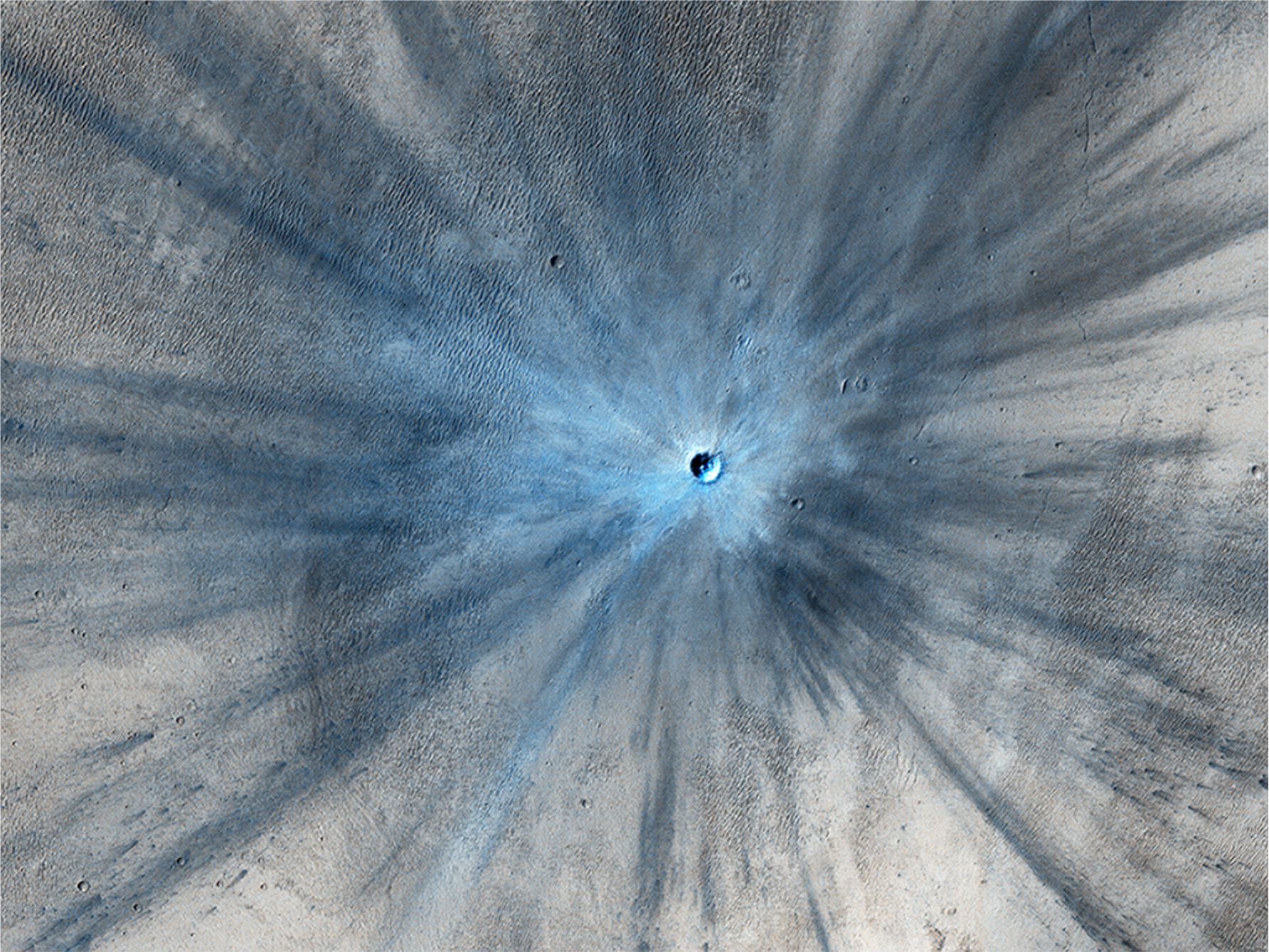
HiRISE has imaged several recent impacts on Mars surface. This one was acquired on November 19, 2013 – images of the site between 2010 and 2012 bracket the impact timing. The crater is 30 m diameter. Impact resulted in a spectacular ray-like zone of ejecta that spreads up to 15 km from the site and partly covers an extensive sand dune field. Image credit: NASA/JPL-Caltech/Univ. of Arizona
The success of the Apollo lunar seismic experiments (1969 to 1977) provided a real boost to Mars exploration. Exploration of the Martian surface began in earnest in the mid-1970s. The Soviet Union had previously attempted to land two vehicles on Mars in 1971 (Mars 2 and Mars 3). Mars 2 crashed; Mars 3 landed successfully but ceased to operate 20 seconds after alighting, without sending any useful information. However, the two Mars orbiters did continue to acquire images for several months.
Mars exploration continued with NASA’s Viking 1 and 2 orbiters that acquired more than 52,000 images of the martian surface. Both Viking landers successfully alighted the surface about 3 months apart in 1976, Viking 1 at Chryse Planitia, and Viking 2 at Utopia Planitia near the margin of the polar ice cap and 6420 km from its cousin. Both landers were able to sample and chemically analyse air and soil (the first time this had been done) and record various weather parameters. The seismometer on Viking 1 failed to operate. That on Viking 2 functioned for 19 months but because it was located on the lander itself the signal to noise ratio was too low to confidently tease marsquakes from wind-generated signals. However, the lessons learned from these and the Apollo missions were successfully applied to Mars InSight experiments 30 years later.
Mars InSight
(The acronym is easier to remember than its full title – Interior Exploration using Seismic Investigations, Geodesy, and Heat Transport).
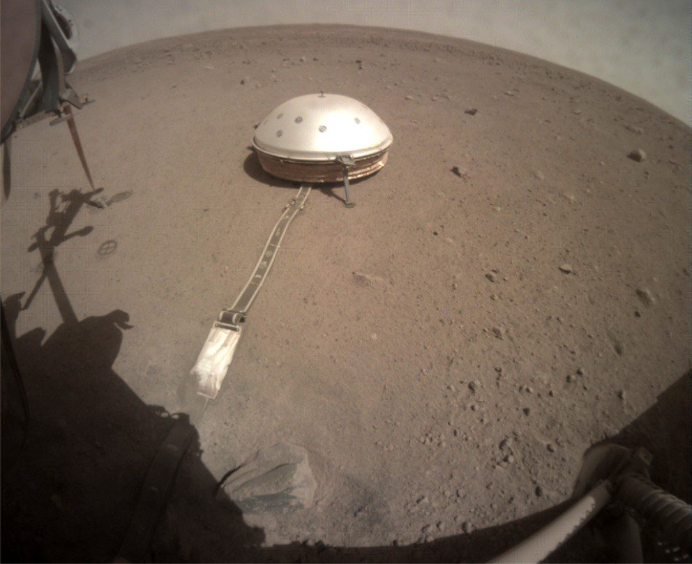
InSight landed in Elysium Planitia on November 26, 2018, and deployed its seismometer (SEIS) to the martian surface using a robotic arm. Seismic data was recorded until the operation shut down after December 15, 2022 (because dust on the solar panels had reduced their power output).
SEIS recorded events across a broad spectrum of frequencies which means it could record different kinds of seismic events (marsquakes, impacts), but also had to contend with high frequency wind and thermal noise. Thermal noise is generated from heating and cooling of the surface bedrock and regolith, analogous to that found with the Apollo lunar records. However, the experience with seismic noise gained from both Apollo and Viking 2 experiments allowed seismologists to see through these background signals to tease out the lower frequency signals relevant to Mars internal structure. Signal scattering and seismiccoda (a kind of echo or ringing) also tend to mask surface waves – these problems were encountered with the Apollo experiments. Like moonquakes, marsquakes are long lived, continuing for 10 minutes and more because of scattering. In fact, the ringing from one event caused by a meteoroid impact lasted several hours.
InSight’s seismometer (SEIS) was deployed by a robotic arm to sit directly on the martian regolith. The robotic arm covered the tether with a layer of loose soil to protect it from wind-blown sand and to minimize acoustic noise. The dome also acted as a shield against wind and thermal effects. Dome top is about 80 cm high. SEIS weighed 29.5 kg.
Seismic waves
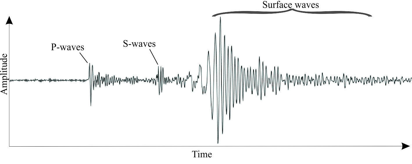
The symptoms of Earth’s indigestion and hiccups are recorded by seismograms as a succession of seismic wave arrivals. Compressional P waves have the highest velocities and are first to arrive – these are the primaryarrivals. They are followed by slower secondaryshear or S waves. Both P and S waves are referred to as body waves because they are transmitted at depth through a planetary body; it is these signals that provide most of the information on a planet’s deep internal structure. The time delay between the first P and S arrivals is related to the distance to the quake epicenter.
A typical Earthquake seismogram: P-waves arrive first, followed by S-waves. S-waves tend to have lower frequencies than P-waves (more spread out on the graph), but higher amplitude. Surface waves also have the high amplitude and lower frequency than body waves. There can be significant variation on this pattern depending on quake depth, strength, rock composition, and background noise.
P wave deformation is compressional, producing back-and-forth motion at the surface (i.e., motion parallel to the direction of wave propagation). Swaves produce up-down and side-to-side motion at the surface (orthogonal to the direction of wave propagation) and tend to be more destructive. S waves are not propagated through fluids (water, gas, igneous melts). Attenuation of S waves at depth in planetary bodies is commonly attributed to a liquid core, or to partial melting in the mantle.
Surface waves confined to the shallow crust comprise a second set of secondary waves that arrive after the body waves (they are slower and have farther to travel). Rayleigh waves produce a rolling ground motion with vertical and horizontal components of movement, and Love waves propagate like S waves but only generate side to side ground movement; they are also attenuated in fluids. Surface waves are most intense following shallow crustal quakes and meteoric impacts; deep quakes produce less intense surface waves.
Marsquakes
More than 1300 marsquakes were recorded over four years of the experiment. Most were of tectonic origin and generated beneath the Martian surface; a few were caused by meteoroid impacts or air bursts. Ninety events having moment magnitudes of 2.5 – 4.2 occurred at teleseismic distances (i.e., distances >1000 km from SEIS).
Two groups of marsquakes have been identified based primarily on frequency: Low frequency (LF) events less than one Hz, and high frequency events (HF) greater than one Hz. HF events are the dominant group and where P and S waves can be identified are attributed to quakes in the crust. LF events usually have recognizable P and S waves and are attributed to deeper quakes. Very high frequency events are mostly caused by thermal responses to diurnal changes in surface temperatures.
Earthquake epicenters can be located accurately because of the large number of seismometers distributed globally. Identifying moonquake epicenters also had the advantage of distributed Apollo seismometer stations. The InSight experiment had only one seismometer such that location of marsquake epicenters required accurate identification of P and S wave arrivals and an a priori seismic model of the martian interior. Note that a general picture of the martian interior (crust, mantle, core) had already been determined from gravity, electromagnetic, and orbital data – what wasn’t known at the beginning of the InSight experiment were accurate depths to the core-mantle-crust boundaries, or the nature of these boundaries.
Signal processing distinguishes between body and surface waves, and between direct P or S waves, and core-reflected and surface-reflected waves. The time delay between P and S waves can be used to estimate to the distance from the epicenter to the seismometer; the same method can also be applied to P and S waves that have been reflected once (designated PP and SS respectively). The modelling process is iterative where both seismic and physical models of the Martian interior are continually updated as the analysis proceeds (for details see Durán et al., 2022, PDF available; and Lognonné et al., 2023, Open Access).
The computed P and S wave velocity-depth profiles are reproduced in the diagram below. Analysis of the low frequency events indicates that their P waves did not traverse deeper than 800 km, much shallower than the expected depth to the core-mantle boundary. S waves on the other hand traversed depths of about 1500 km below which they were strongly attenuated.
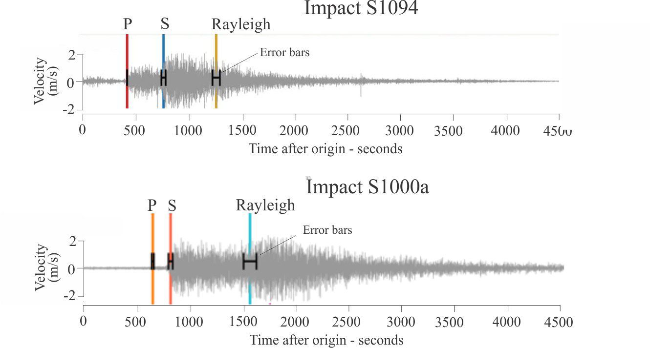
However, two notable events in 2021 did produce core-diffracted P waves and surface waves – both were meteoroid impacts (i.e., meteorites or comets) at teleseismic distances from SEIS; both produced large seismic responses with magnitudes >4. The earlier event, S1000a was 7455 km from SEIS and the second event, S1094 was 3460 km (S indicates mission sol, or martian day). Their craters are 130 m and 150 m diameter respectively.
Martian impacts
Six meteoroid impacts or air bursts were recorded by SEIS in 2021, including the S1000a (September 18) and S1094 (December 24) events. Impacts tend to produce relatively strong surface seismic waves, the energy of which depends on impactor size, velocity, and to some extent the obliquity of its trajectory. Two methods of detection and signal analysis have been applied to the martian events:
Surface impacts and air bursts create a fair bit of noise and atmospheric disturbance that produce above-ground acoustic signals. On Mars, these chirps can be recognized for impacts <300 km from the seismometer – at distances >500 km the acoustic signals are dampened by Mars thin atmosphere.
Depending in impact size, a mix of body and surface, direct and reflected seismic waves.
Identification of P and S body waves, and surface Rayleigh waves from the S1094 impact (left) recorded by SEIS December 24, 2021, and S1000a recorded September 18, 2021. Time is in seconds from the first P arrival. Note the long duration post-Rayleigh wave signal run-out to more than 3000 seconds (50 minutes) for S1094 and 3600 seconds (60 minutes) for S1000a. Modified from Posiolova et al 2022 Figures 3 and S1 respectively.
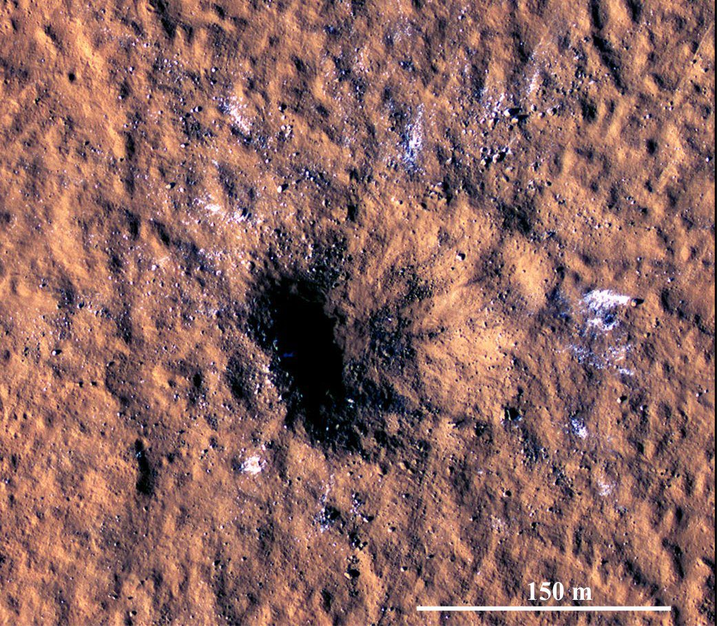
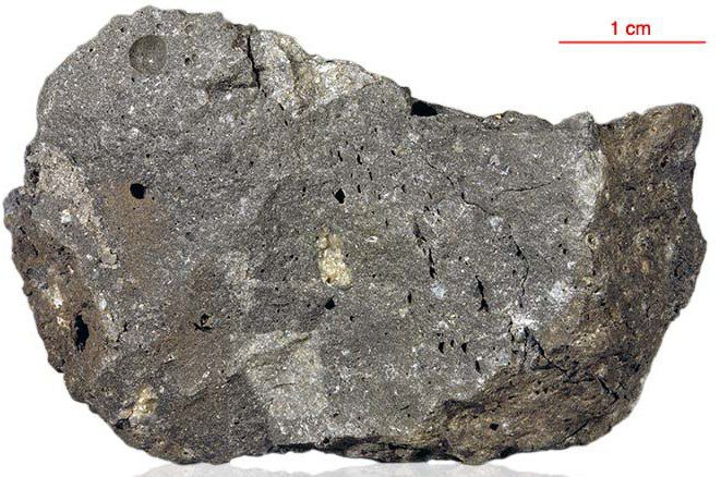
A HiRISE image of the S1094 crater in Amazonis Planitia taken 2-3 Sol after impact. The crater is asymmetric, about 150 m diameter and 21 m deep. Based on empirical models, the impactor was probably 5-12 m across (on Earth it would have burned up on entry). Posiolova et al., (op cit.) calculate the angle of impact at about 30o – the ejecta blanket extends up to 37 km from the crater because of this low angle. White debris in the ejecta is thought to be water ice. Image Credit: NASA/JPL-Caltech/University of Arizona.
The craters from S1000a and S1094 were located by Mars Reconnaissance Orbiter less than 3 Sol after their seismometer recordings (using before and after images of the martian surface). Thus, the impact times and locations are known accurately, providing useful calibrations for marsquake epicenter distance calculations (for example using S-P or SS-PP arrival times). For the two events, the SEIS calculated distance to S1000a was 7591 +/- 1240 km compared with the actual distance of 7461 km; for S1094 the calculated distance is 3530 +/-360 km compared with the measured 3460 km (both differences <1.9%) (Posiolova et al., 2022). The S1094 impact was also notable because it dislodged and scattered blocks of water ice (the bright patches on the image below).
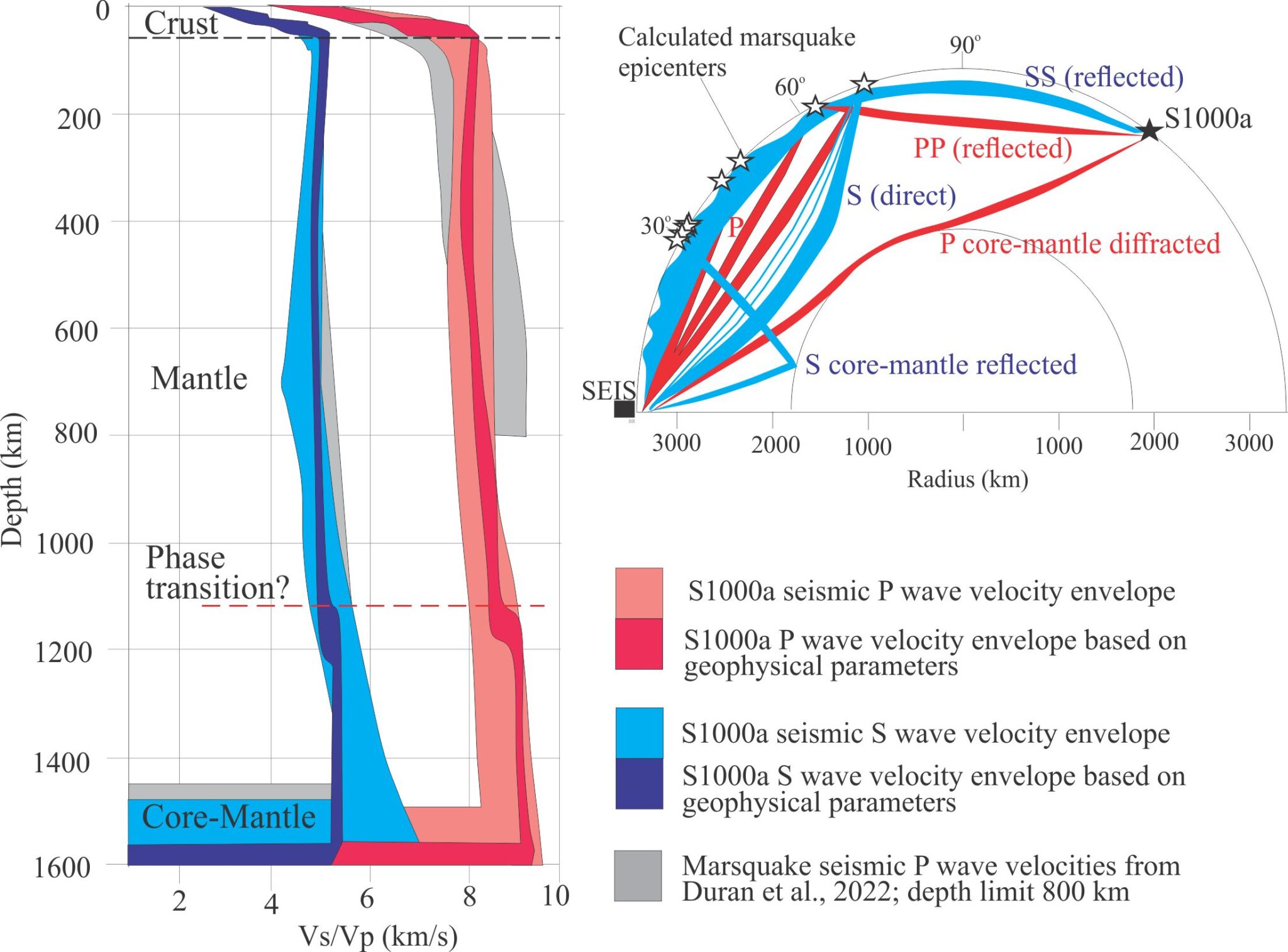
Analysis of the S1000a data indicates P wave diffraction (deflection at a boundary rather than reflection) at a depth between 1500 km and 1600 km (corresponding to a radial distance of 1890-1790 km), that probably corresponds to the core-mantle boundary. The previous P wave depth determined from deep low frequency marsquakes was 800 km (Mars radius is 3,389.5 km measured from the core center).
Velocity profiles computed for the S1000a impact show both P and S waves transmitting to 1500-1600 km depth. Light red and blue envelopes include the actual impact seismic data; darker colours define envelopes for velocities calculated from other geophysical parameters. The grey envelopes indicate data from low frequency marsquakes – for these events there are no records of P waves transmitting deeper than 800 m. The ray path map (top right) shows direct (P, S) and reflected (PP, SS) body and surface waves for the S1000a impact and a few low frequency marsquakes. The S1000a P wave was a direct arrival at SEIS although it was diffracted by the core-mantle boundary. Modified from Durán et al., op cit, Figures 3A, 3C.
Mars internal structure: Velocity-depth profiles
Regolith
Data for the upper few decimetres of relatively unconsolidated regolith was generated from impacts used to drive a heat probe into the soil. Conversion of signals indicates seismic velocities for P waves of 0.098 to 0.163 km/s, and for S waves 0.056 to 0.074 km/s through the uppermost 30 cm of regolith beneath InSight (Lognonné et al., op cit).
Crust
Crustal thickness beneath InSight is about 40 km; the base is indicated by an abrupt increase in both P and S wave velocities. Velocity profiles indicate at least two discontinuities within the crust: one at 8-11 km, above which S wave velocities are 1.7 – 2.1 km/s and P wave velocities are 2.5 – 3.3 km/s, corresponding to basalt with 7-10% unfilled porosity (primarily vesicles). The second discontinuity occurs at 20 +/- 5 km. Thus, the data indicates a 3-layered crust. The global Mars average crustal thickness determined from orbital gravity and topography is 30-72 km Lognonné et al., op cit).
Core-Mantle
The conclusion that Mars core is iron-rich is based primarily on bulk density, gravity and orbital data. Various geophysical, seismic, orbital moments models have been used to calculate the core radius and core-mantle boundary (discussed in some detail by Lognonné et al., op cit). There is reasonable consensus that the core-mantle boundary is between 1,500 and 1,600 km depth, corresponding to a core radius of 1,890-1,790 km. P waves from meteoroid impacts S1000a and S1094 confirm this boundary depth, a depth that also corresponds to significant attenuation of shear (S) waves.
There is a P and S wave discontinuity at about 1,100 km depth that may correspond to a mantle mineral phase transition and an increase in mantle density. This boundary may be analogous to mineral phase – density transitions determined for Earth’s mantle, for example in olivine or perovskite (also common minerals in chondritic meteorites). Average core density is about 6,000 – 6,300 kg/km3.
There is still debate about the structural aspects of Mars’ core. Does it have a solid inner core and molten outer core (S wave behaviour indicates likely melting at the core-mantle boundary) or is the entire core liquid? Le Maistre et al., (2023) argue the latter based on detailed measurement of Mars rotation using InSight RISE data (Rotation and Interior Structure Experiment), demonstrating a rotational wobble that is best explained by a liquid core. The core radius in their calculations is 1,835 ± 55 km, and the bulk density is 5,955–6,290 kg m−3 corresponding closely to the values obtained from seismic and other geophysical data.
Unlike Earth, there is no evidence for rotation of Mars outer core. As a consequence, Mars has no geomagnetic field to shield it from solar and cosmic radiation. Given the almost overwhelming sedimentary and geochemical evidence for ancient seas and lakes on Mars surface, Mars atmosphere must have been significantly denser than at present (Mars present atmospheric pressure is less than 1% of Earth’s at sea level) and it is likely that core conditions were very different in the past. Stripping of Mars’ atmosphere by solar winds was probably a direct result of the slow down of core rotation and consequent loss of its geomagnetic shield.
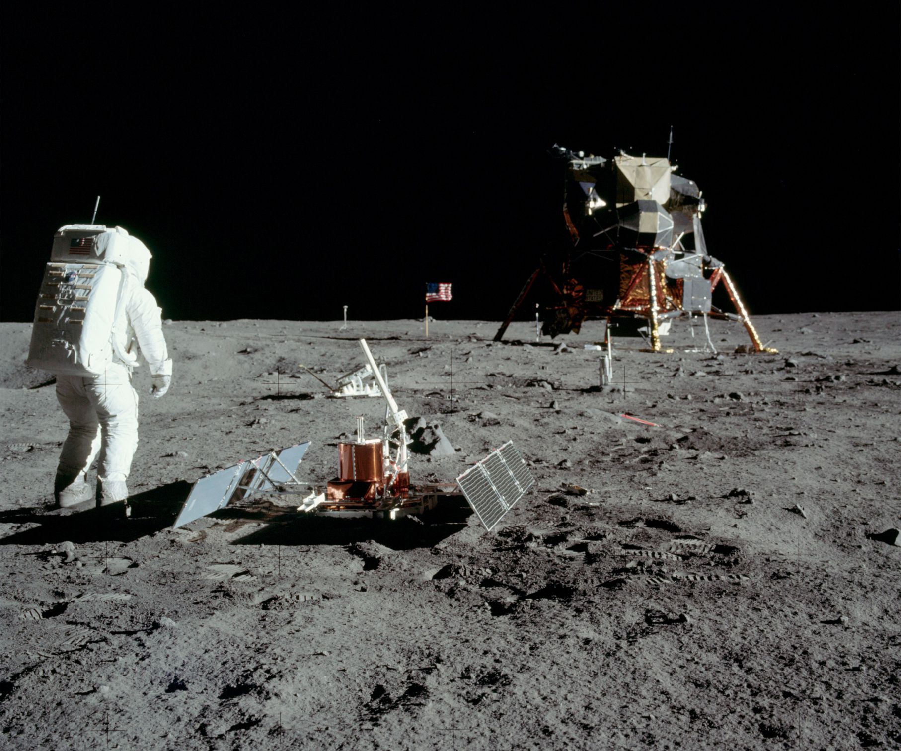
The first seismometer to be installed on a planetary body other than Earth, was at the Apollo 11 landing site on Mare Tranquillitatis. The passive seismic experiment lasted about 3 weeks. Here, astronaut Buzz Aldrin has deployed two solar panels and antenna. Several boot impressions are visible in the soft regolith soil. Image credit: NASA
Moonquakes, impacts, and bazookas
The internal structure of Earth is conveniently pictured as a three-layered sphere (or more correctly an oblate spheroid):
A thin, brittle crust.
A mantle that is solid but ductile. The crust and lithosphere mantle are organized into tectonic plates that, over the immensity of geological time are continually remade. Partial melting of the mantle is also the source of most intrusive and volcanic magmas.
A central core composed mostly of nickel and iron, that is itself layered with a solid inner core, and a fluid outer core.
How do we know this?
There is a diverse array of geophysical and geological information that allows us to decipher Earth’s structure, and that of the other planets and their moons:
Measurement of gravity fields. The strength of a gravity field for any cosmological body depends on the body mass (that in turn depends on volume and density). In general, the larger the mass, the stronger the gravity field. Gravitational signatures within a body can vary because of regional differences in rock density.
Measurement of electromagnetic fields. Earth’s magnetic field is generated by convective rotation of the hot, fluid outer core. In contrast, neither the Moon nor Mars has an internally generated magnetic field which means that their cores are probably stagnant (that may not always have been the case).
Heat flow: There are three primary sources of heat in planets and their satellites: Remnant heat from planetary accretion; heat generated by radioactive decay, and heat generated by gravitational tidal forces – the latter may be an important source of heat for magma generation in moons like Io.
Seismic data generated from natural (earthquakes, impacts) and artificial energy sources (e.g., explosives, airguns) have provided a wealth of information on the internal structure of Earth. Unlike gravity and geomagnetic signals that can be measured remotely, seismic signals can only be recorded by instruments in the field. The first seismic signals ever recorded from a planetary body other than Earth were those from instruments left on the Moon by Apollo 11 astronauts in 1969. Subsequent seismic experiments were installed by Apollo missions 12, 14, 15, 16, and 17. The experiments were terminated in 1977. The only other planetary body for which seismic data is available is Mars – the InSight mission began recording December 2018 and ended December 20, 2022.
The Apollo seismic arrays
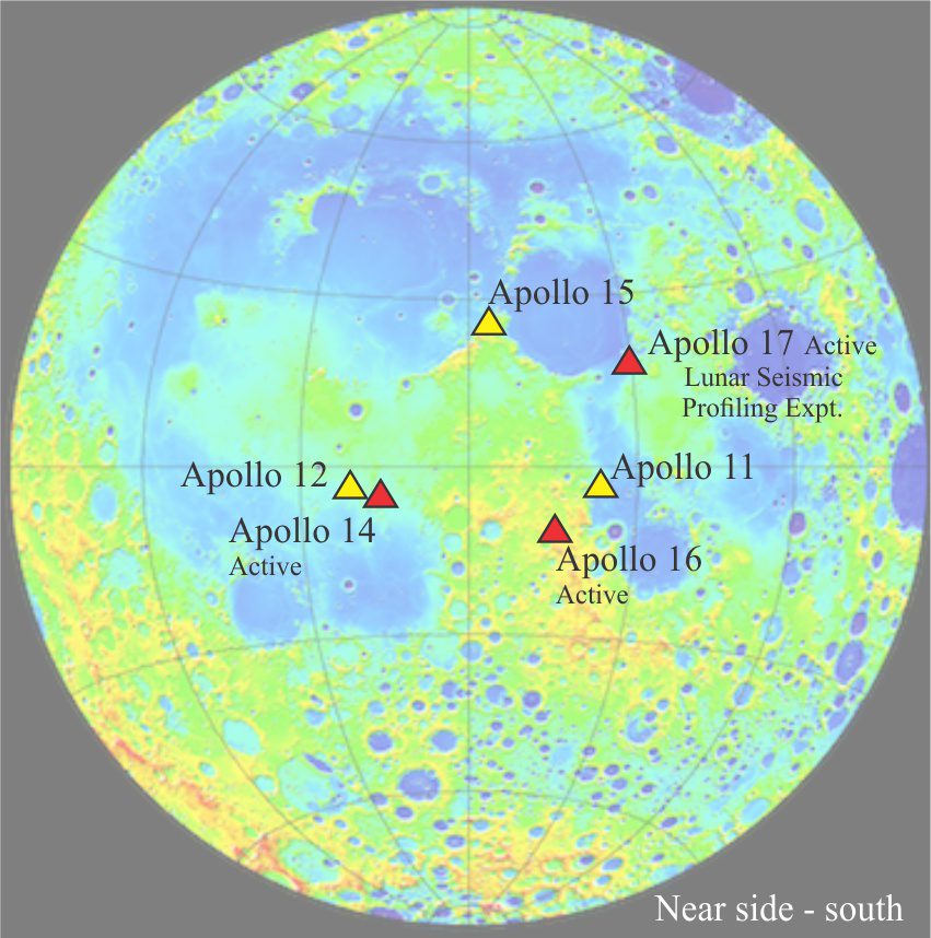
Apollo landing sites and seismic stations. The base map is from the Lunar Reconnaissance Orbiter mapping mission. Modified slightly from Nunn et al., 2020, Figure 1.
Seismic instrumentation included seismometers at all sites, and geophones at Apollo stations 14, 16, and 17. Passive experiments were conducted at stations 11, 12, 14, 15, and 16; the Apollo 11 experiments only last one lunation in 1969 (one lunar month), the other stations operated until 1977 (passive experiments record natural seismic events, like earthquakes and impacts). Active experiments, using artificial sources of seismic energy, were conducted at stations 14 and 16 (three geophones each in linear arrays), and 17 (four geophones). Two types of energy source were used: thumpers triggered by small explosive charges, and explosives lobbed a few 100 metres from the stations by grenade launchers.
The active experiment at station 17 (Lunar Seismic Profiling Experiment) was designed to explore Moon structure to a depth of several kilometres. Geophones were arrayed in a triangle where apices were 100 m apart with one sensor in the middle of this array. After completion of the experiment the station converted to a passive seismometer. The explosive experiments were initiated after the astronauts had left the Moon (a sensible H & S strategy).
The overall array of Apollo seismometers is important because they allow fairly accurate identification of epicentres (using triangulation) where signals from individual moonquakes are recorded at each station.
The Lunar Surface Gravimeter was installed at station 17 to detect gravitational waves, but it was incorrectly calibrated and failed to produce sensible data. As a backup, it was used as a seismometer.
Moonquakes
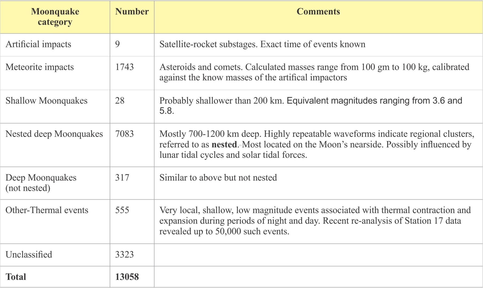
More than 13,000 events were recorded over the 8 years of operation, summarized in the list below. There are some interesting comparisons between Moonquakes and Earthquakes (information mostly from Nunn et al., 2020. Open Access).
Moonquakes have long duration after first arrivals, in part because of scattering of seismic (P and S) waves.
Seismic wave scattering is probably due to the intense impact fracturing of the upper few hundred metres of Moon crust. Scattering produces a kind of ringing, or echo effect that is referred to as seismiccoda (coda is a term used in music composition to indicate a repeated theme).
The high number of impact events reflects the absence of a lunar atmosphere (on Earth most meteorites burn up or fragment).
Shallow crustal events (shallower than 200 kilometres deep) are rare compared with Earth, reflecting the absence of plate tectonic processes in the Lunar environment. Shallow event signals are similar to intraplate Earthquakes. Magnitudes as high as 5.7 were recorded. No (gravitational) tidal periodicity has been identified in any of this data.
Deep Moonquakes are most numerous. Most occur between 700 and 1100 kilometres and have magnitudes less than 3. There is a periodicity to clustered (locally nested) events with strong peaks at 13.6 and 27 days, that are attributed to tidal phases of the Moon. Addition periodicities at 206 days and 6 years are attributed to solar tidal influences.
A significant number of very low magnitude, local events are attributed to diurnal thermal expansion and contraction. Recent reprocessing of Station 17 data shows more than 50,000 of these events occurred over 8.3 months (Nunn et al., 2020, op cit.). The acme of thermal Moonquakes coincides with the lunar sunrise and sunset.
Artificial impact events were generated by crashing satellite substages onto the Moon surface.
Lunar structure: topography and geomorphology
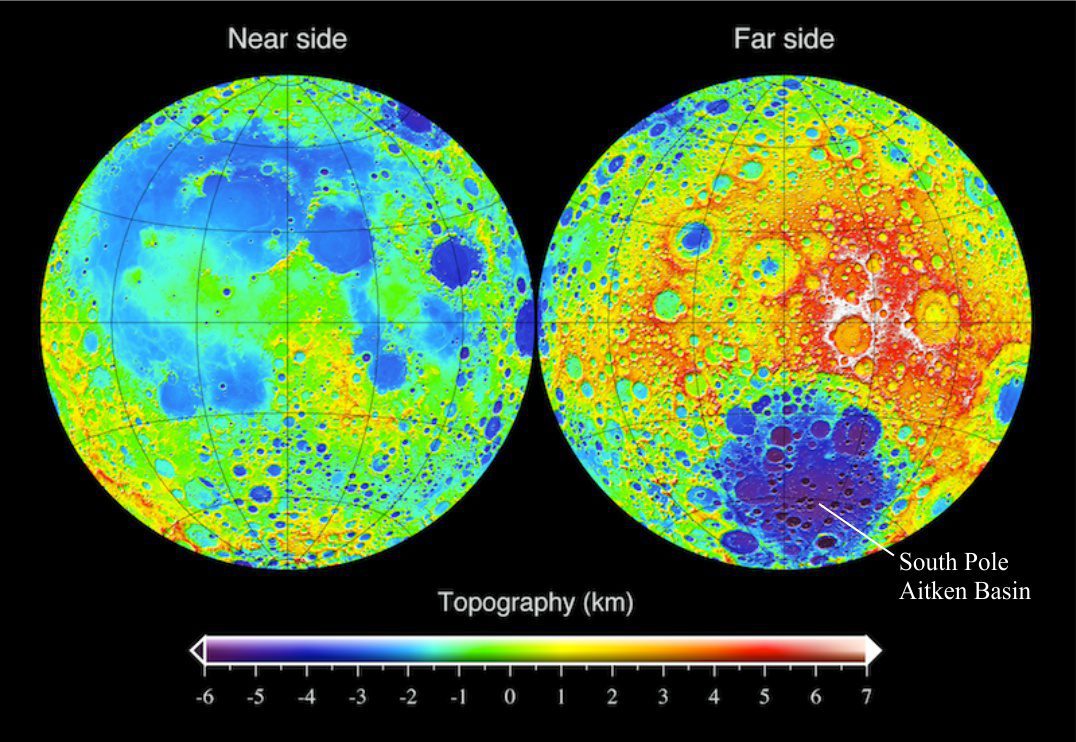
Detailed mapping of Moon topography has been a primary mission task of the Lunar Reconnaissance Orbiter, operating since September 2009. Impressive colour enhanced compilations of the near (visible) and far side topography show marked differences in relief and geomorphic structure between the two sides. Because Moon is almost a perfect sphere, positive and negative differences in elevation are measured from a datum that corresponds everywhere to an average radius of 1737.4 km. The difference between the lowest and highest elevation points is about 18,000 m.
Detailed topography maps of the Lunar near side (left) and far side, based on data collected by the Laser Altimeter onboard Lunar Reconnaissance Orbiter. Elevations are measured relative to the average lunar radius (datum). Surface features as small as 45.7 cm can be resolved. Some of the highest elevations are located on the far side (white colours surrounding craters slightly right of centre). The lowest elevations occur near the far side South Pole. Image credit: NASA
The visible surface of the Moon is made up of two main geomorphic elements:
Broad, relatively flat impact plains, or maria (singular mare) underlain by extensive basalt lava flows and lava tubes (these are the large dark splodges visible from Earth, interpreted as oceans or seas by enlightenment astronomers, hence the name – mare). Most formed from catastrophic impacts 3.1 to 3.9 billion years ago, and as such are some of the youngest lunar surface structures. Some are multi-ring impact structures. Extrusion of basalt lavas may have resulted from initial impact melts, but it seems that eruptions also continued long after impact, possibly triggered by later heating events. Most maria are located on the moon’s near side. A very large mare near the south pole of the far side has depths of 10 km (this is the South Pole Aitken Basin). Basalt mineral composition based on Apollo samples shows predominantly clinopyroxene, calcium plagioclase, olivine, and iron–titanium oxides like ilmenite and spinel.
Rugged, mountainous Highlands pockmarked by a myriad craters. Highland regions are most pronounced on the Moon’s far side where elevations reach 8-10 km above the lunar datum. Most of this ruggedness is a result of impacts – a combination of post-impact rebound and ejecta fall-back. The effects of successive, repeated impacts resulted in dissection of landforms, intense brecciation, melting, and shock metamorphism of bedrock. Thus it is likely that the original crustal bedrock has been reworked numerous times, a process called impact gardening (Pernet-Fisher and Joy, 2016). Attempts to decipher the original composition of the crust in highland regions need to “see through” these structural and geochemical changes.
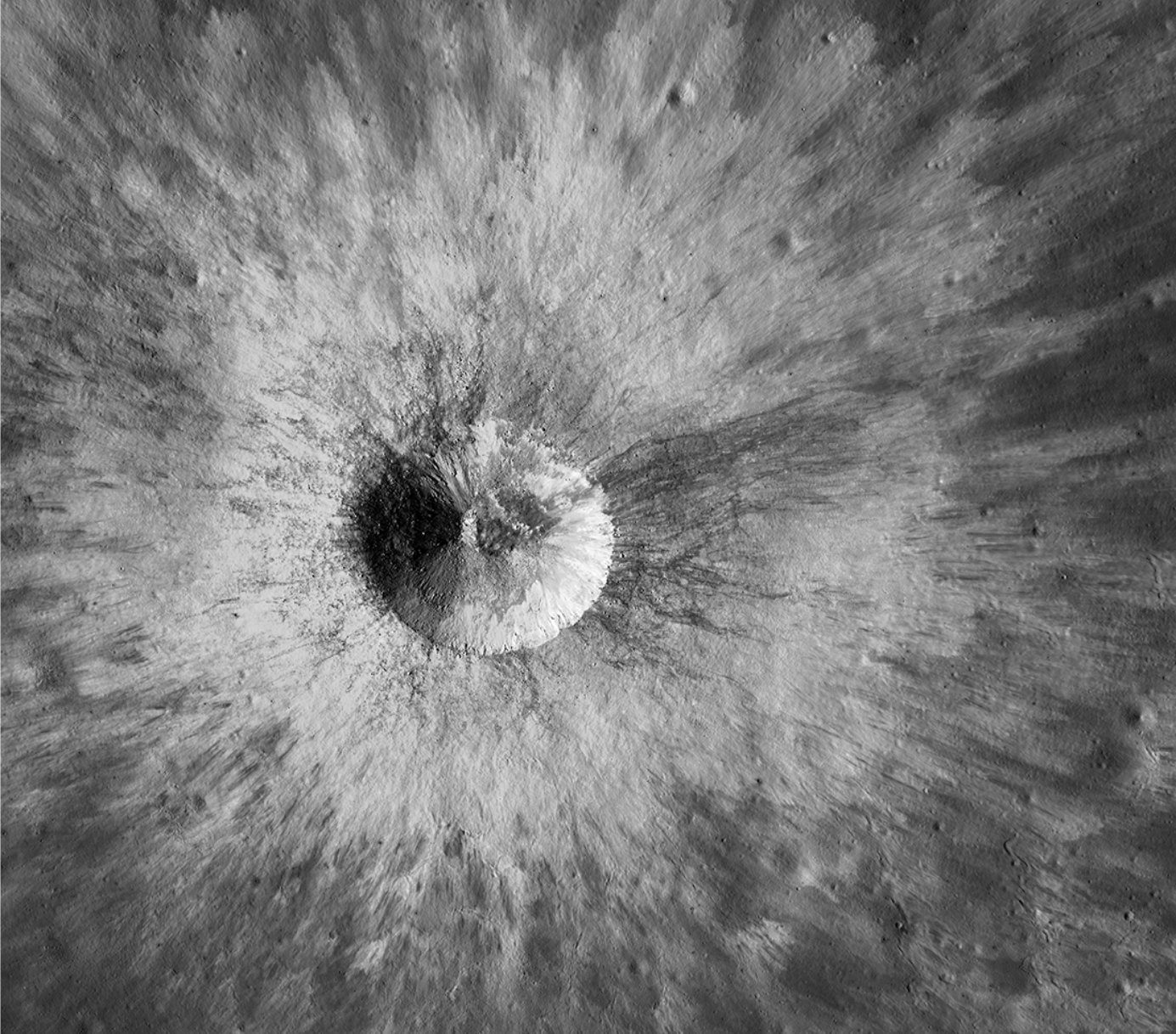
A relatively young crater, 1.8 km in diameter with well-preserved raised rim and a ray-like ejecta blanket. It is located in the partly buried and older crater Hedin. Smaller impact structures are also visible beneath the ejecta. The regolith surrounding this structure is a good example of impact gardening, likely composed of material derived from multiple impacts. Image Credit: NASA/GSFC/Arizona State University 2018 Lunar Reconnaissance Orbiter.
Layered structure of the Moon
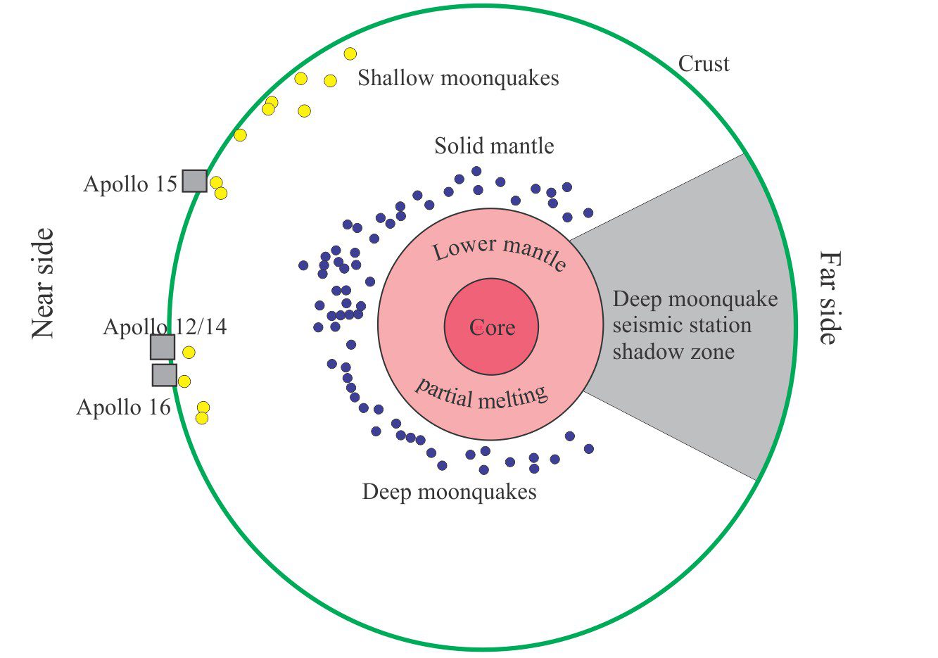
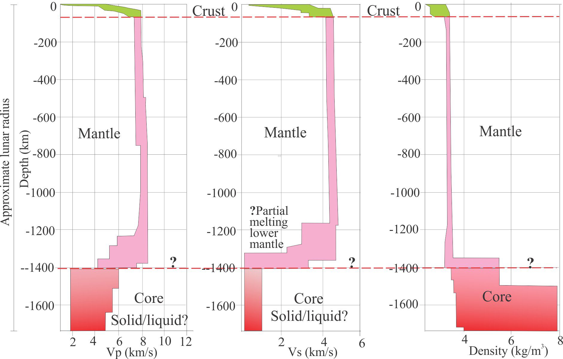
The internal structure of the Moon, based on data and models to 2019 (not to scale). The diagram, borrowed from Garcia et al., 2019, Figure 5, conveniently shows the relative positions of Moonquake epicenters, with shallow events generally less than 200 km deep, and deep events 700-1100 km deep – and no intermediate events. In this version the liquid core, radius less than 350 km, is surrounded by partially melted lower mantle.
Regolith and megaregolith
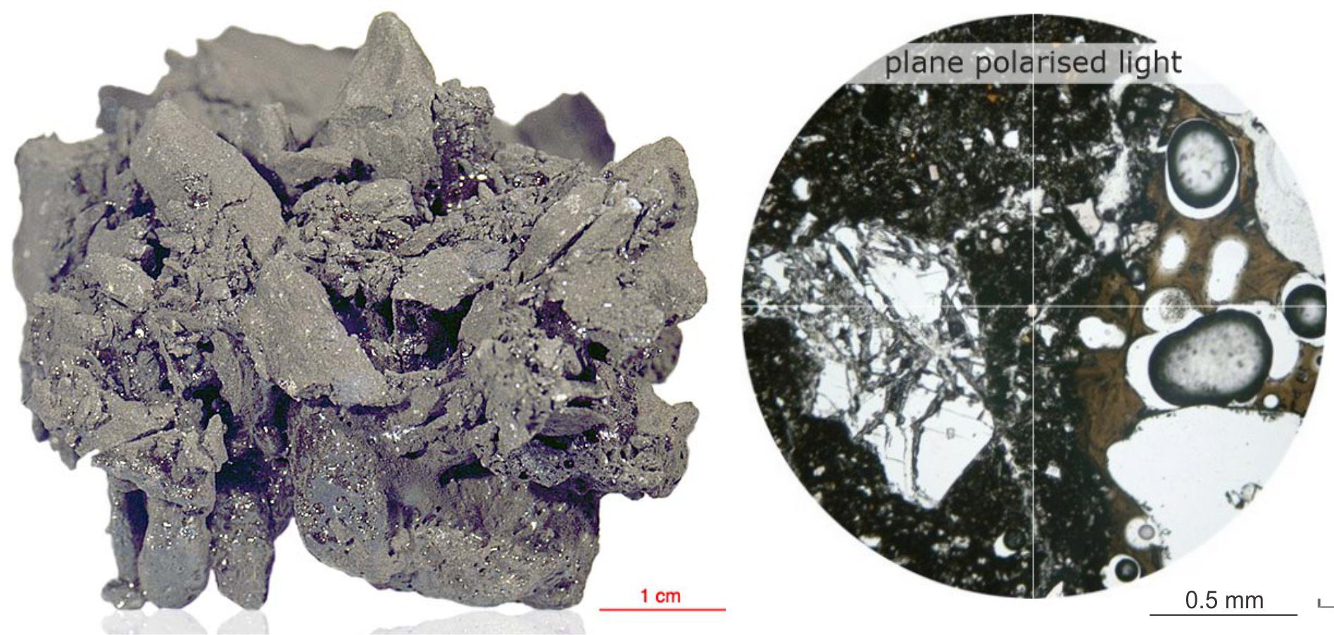
A sample (#72435) of fine-grained impact breccia from shallow regolith, collected by Apollo 17 astronauts. It contains several small fragments of bedrock and probably earlier formed regolith, welded by impact-melt glass. Vesicles indicate the release of volatiles during the high-temperature impact event. Reworked minerals like plagioclase, olivine and pyroxene commonly feature shock metamorphic textures. Ar/Ar dating of an included fragment yielded an age of 3.86±0.04 billion years. Image credit: Original image from NASAwith subsequent enhancement by Virtual Microscope(Creative Commons) .
The entire surface of the Moon is covered by a regolith veneer, averaging 4-5m thick. It consists of intensely fractured and brecciated bedrock (basalt, anorthosite), crystals derived from bedrock, dust, glassy welded agglutinates, and impact glass (Noble 2009, PDF available). Breccia compositions, based on Apollo samples, range from friable aggregates to hard, glassy, vesicular rock. Porosity at the surface is as high as 50%. Accordingly, seismic velocities range from 0.1 to 0.3 km/s.
Megaregolith applies to much thicker deposits associated with large impacts in the Highlands. Thicknesses are uncertain, but on a volume basis could be greater than 2.5 km.
An example of very porous, agglutinate impact breccia, where most of the clasts are reworked, fine-grained breccia impact gardened from older impact events (NASA sample #70019). The fragments are welded by dark coloured glass. The thin section image (right, plane polarized light) shows a plagioclase crystal shattered during shock metamorphism, and a vesicular glassy fragment, also derived from an earlier impact heating event – the vesicles are oval-shaped. Both fragments are embedded in black glass. Image credit: Virtual Microscope
Lunar Crust
Models of crustal thickness vary from 34 to 43 km and 30 to 38 km, depending on the use of gravity or seismic data (see Garcia et al., 2019 for discussion). The average bulk density is 2550 kg/m3 based on gravity models. Thickness values for the far side are about 15 km greater than the near side.
Seismic P and S wave velocities increase steadily through the upper 20-25 km of crust, below which P wave velocities increase abruptly to 6.8 km/s and continue at this value to the base of the crust (Garcia et al., op cit. Figure 4); the velocity corresponds to that expected in an anorthosite crust. It is hypothesized that the acoustic boundary at 20-25 km corresponds to the depth of impact fractured crust.
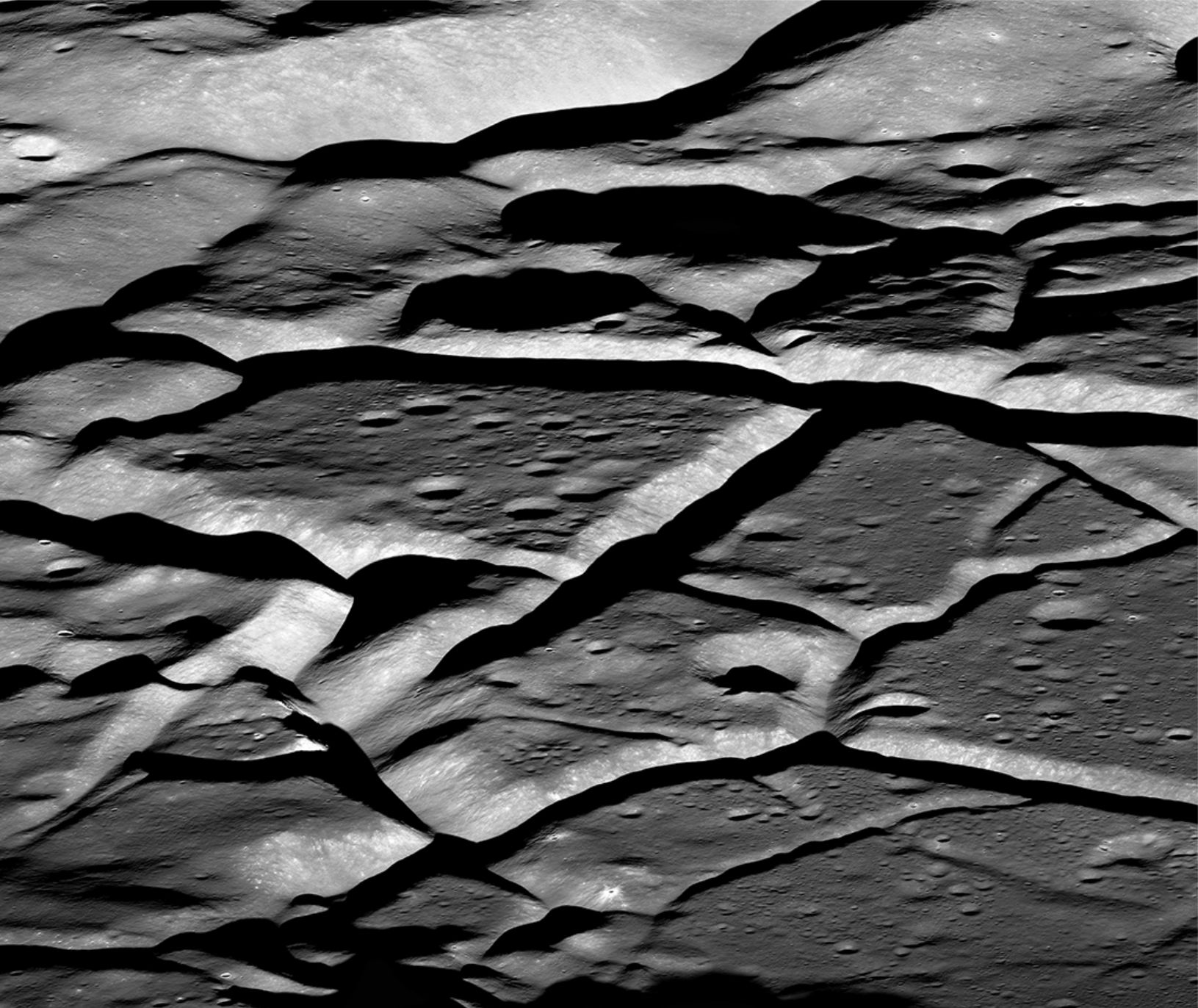
Intense fracturing across the floor of Komarov crater is probably due to post-impact magma intrusion. Bedrock fracturing like this is likely responsible for seismic wave scattering in the upper crust. Field of view is 15 km wide (the crater is 85 km in diameter). Image acquired by the Lunar Reconnaissance Orbiter, 2018. Image credit: NASA/GSFC/Arizona State University.
Lunar mantle
P wave velocities of about 6.8 km/s and S wave velocities about 4.5 km/s continue to depths of 1200 km, whereupon there is a fairly abrupt decrease in P and S wave values (the deep Moonquakes range from 700-1100 km depth). Garcia et al., (op cit.) note that there are significant uncertainties with seismic data below 1200 km. The mantle is probably silicate-rich, represented by olivine- and pyroxene-rich rocks, with relatively consistent densities of 3.4 to 3.5 kg/m3. There is no evidence for convective overturning in the mantle. However, S wave attenuation near the base of the mantle may indicate partial melting.
The boundary between the lunar crust and mantle is well defined in seismic velocity and density-depth graphs; the mantle-core boundary less so. The graphs originally constructed by Garcia et al., 2019 Figure 4 (op cit.), contain data from multiple sources. I have redrawn three of their graphs to show the range of data values for P-wave velocity (Vp), S-wave velocity (Vs), and density. Data values for the crust and mantle to 1200 km depth are constrained but there are significant uncertainties below this depth, particularly with the density data. However, attenuated S-wave velocities indicate likely partial melting in the lower mantle, and possibly the core.
Lunar core
The important seismic attribute of the lunar core is that P waves are transmitted through, but S waves are not. This means that either the entire core is liquid, or that it has a liquid outer shell. Recent models tend to favour a small liquid core ranging from 300 to 350 km diameter, surrounded by a liquid shell 90 to 220 km thick (Garcia et al., op cit.). All evidence indicates an iron-rich core. Core density is probably in the region of 7.8 kg/m3.
Postscript
With all the current and planned activity, lunar accommodation and parking space will become a premium. Lunar Reconnaissance Orbiter will continue mapping and looking for locations suitable for possible extended habitation. The recently inserted Indian satellite Chandrayaan-3 will presumably undertake similar tasks, with a lander near the South Pole. China has successfully landed the first rover (Chang’e-4 spacecraft) on the far side. All this activity is ostensibly of a scientific nature, but it would be naïve to think that geo-lunar political considerations are not part of this mad lunar rush, on the heels of a post-Apollo hiatus of more than 40 years. Let’s hope that science remains the primary rationale for all this effort and expense, that the Moon doesn’t become yet another garbage dump of human folly.
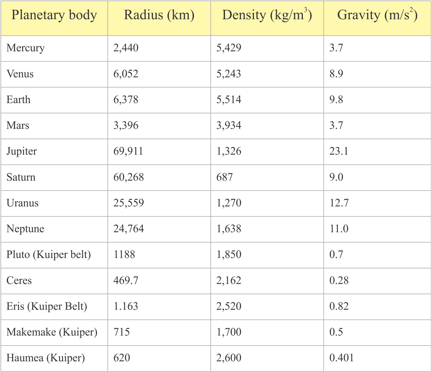
Jupiter’s moon Io – the only body in our solar system, other than Earth, to show active volcanism
Some terminology for planetary geology, the solar System, moons, asteroids, comets, meteorites, exploration, measurement, and related topics.
Absolute magnitude: The brightness of an object if it was 10 parsecs, or 32.6 light years from Earth. Usually applied to stellar objects. The brighter the object the lower the number according to a logarithmic scale. Magnitude numbers can also be negative for really bright objects, like our own sun. So, the difference in brightness between magnitudes 1 and 2 is 2.512 times. The scale can be applied to stars, planets, and comets. Measured magnitudes (light flux) are usually calibrated against standard stars for which the flux, or magnitude is known accurately.
Absolute zero: The theoretical temperature, measured in degrees Kelvin (K), where the kinetic energy of atomic particles is zero – everything is at complete rest. The temperature value corresponds to -273.15o C and -459.67o F. Thus, 0o C is 273.15o K.
Achondrites: This group of meteorites lacks chondrules and has igneous textures and compositions that indicate a degree of magmatic differentiation and metamorphism, having formed on all manner of bodies such as planets, moons, and asteroids. Hence, they are more like many basic and ultrabasic Earth lithologies. Mineralogically, they contain pyroxenes, olivines, Ca-rich plagioclase, traces of other silicates, and FeNi Kamacite. Achondrites derived from asteroid collisions with Mars and the Moon have been found on Earth. Lunar-derived achondrites have identical mineralogical and geochemical compositions to lunar rock samples collected by the Apollo missions.
Active seismic experiments: Use of artificial sources of seismic energy are common practices for Earth bound seismic investigations. The method was used for the first time on another planetary body during Apollo missions 14, 16, and 17. Two types of energy source were used: thumpers triggered by small explosive charges, and explosives lobbed a few 100 metres from the stations by grenade launchers.
Active volcanism on Venus: Images obtained by the Magellan spacecraft between 1990 and 1992 reveal a change in shape of a vent on Maat Mons, one of the largest volcanoes on Venus. Possible new lava flows were also identified. These phenomena appear to confirm recent volcanic activity on Venus (Herrick and Hensley, 2023).
Age of Earth: Current estimates indicated ~4.5 billion years (4.5 Ga). This is based on radiometric dating of moon rocks (4.4 Ga), meteorites (e.g., from Barringer Crater 4.567 Ga), and the oldest (so far) zircons from Jack Hill, Australia at 4.4 Ga. that indicate a differentiated crust had already developed at that time. It is likely that the age of all other planets in the Solar System have a similar age. Note the Murchison carbonaceous chondrite has been dated at 7 Ga, almost 2.5 billion years before the solar system.
Albedo: A measure of the amount of direct radiation from the sun that is reflected from a surface. Dark surfaces reflect very little radiation; white surfaces (such as ice and snow) reflect the most. On Earth, the ice caps at both poles play a major role in balancing heat radiation from the Sun. Clouds and the sea surface also play an important role in heat transfer to the atmosphere and ocean water masses, balanced by the amount of heat that is reflected back to space.
Alpha Centauri: The closest star system to our Sun, it consists of a double star 4.37 light years away, and a third much smaller star Proxima Centauri that orbits these two. The double stars are named Rigil Kentaurus and Toliman that are about the same size as our Sun, Rigil K a bit brighter, and Toliman about half as bright. Proxima Centauri, a red dwarf, is the closest star at 4.25 light years away. The exoplanetProxima b orbits Proxima Centauri. The Alpha Centauri system is located in the southern sky and is the most distant of the two ‘Pointer’ stars from the Southern Cross.
Altitude (astronomical): Altitude is the angle in degrees or radians of an object relative to some horizontal coordinate. On Earth, an observer’s view of the sky is measured relative to the horizon – the line connecting them is assumed to be horizontal. Thus, an object on the horizon has an altitude of 0o, and at its zenith (overhead) it is 900. A useful rule of thumb is the width of a fist held at arm’s length is about 10o.
Amazonian Period (Mars): The period on Mars from 2.9 Ga to the present day. The period when Mars lost much of its atmosphere, stripped away by the solar wind – Mars magnetic field strength was significantly reduced. Constant sub-zero temperatures and a lack of atmospheric water vapour resulted in very slow weathering. Most of the sand dune seas we developed at this time. The two polar ice caps indicate continuing low temperatures (averaging -63oC), but there is some evidence that they are melting.
Angular velocity: For a rotating body, a measure of the rate of angular change. It is usually stated in radians per unit time, for example the angular velocity for Earth’s rotation about a north-south axis is 1.99 x 10⁻⁷ radians/second. The angular velocity at the equator is the same as that for the poles. cf. linear or tangential velocity.
Antumbra: One of three types of shadow cast by a radiant object. The shadow is lighter than the associated umbra – it will only form if the radiant disc is larger than the body causing the shadow. On Earth, the primary example occurs when the Moon is at its greatest distance from Earth. When it is located between Earth and Sun the shadow does not completely cover the sun’s disc such that the dark region is surrounded by a very bright region – this is also called an annular eclipse.
Aphelion: The farthest distance from the Sun (or any star) of an orbiting body. The term coined by Johannes Kepler applies to planets, comets and asteroids that have elliptical orbits around a star. Etymology – Helios, the Greek Sun God. Cf. Perihelion
Apogee: The farthest distance of the Moon from Earth during its elliptical orbit. Cf. perigee
Apojove: The position on a satellite orbit that is farthest from Jupiter’s center. Cf. Perijove.
Apollo missions: There were 17 manned Apollo missions to the Moon, although the first mission ended prematurely with the tragic loss of its crew. Apollo 11 was the first actual landing with Astronaut Neil Armstrong setting foot on the moon on July 20, 1969. Geological samples totaling 382 kg of bedrock, pebbles, dust and regolith were collected on 6 missions. Passive seismometers were installed on Apollo 11, 12, 14, 15 and 16. Active seismic experiments were undertaken at Apollo 14, 16, and 17.
Apparent magnitude: The brightness of an object as it is seen from Earth. Usually applied to stellar objects. The brighter the object the lower the number according to a logarithmic scale. Magnitude numbers can also be negative for really bright objects, like our own sun. So, the difference in brightness between magnitudes 1 and 2 is 2.512 times. Stars farther than 10 parsecs from Earth will have lower absolute magnitudes (will be brighter) than their apparent magnitudes. The scale can be applied to stars, planets, and comets. Measured magnitudes (light flux) are usually calibrated against standard stars for which the flux, or magnitude is known accurately.
Apsis (plural apsides): The general term for the closest and farthest distances of an orbiting body around its parent body. Around our Sun they are specified as aphelion and perihelion. For the Moon-Earth system the terms are apogee and perigee.
Arc minute: The angular measure that is 1/60 of a degree, or 1/ 21,600 of a complete rotation (360o). An Arc second is 1/60 of an arc minute, or 1/3600 of a degree.
Armillary sphere: Armillary spheres attempted to map the heavens in three dimensions. They were only intended as physical models rather than measurement, but as such they represented attention to detail, and wonderful craftsmanship. They were popular during the Renaissance. One of the better-known spheres was made for Ferdinand I de’ Medici by Antonio Santucci that took 5 years to complete (1593). The sphere contained many of the elements representing the known universe and general theological beliefs. Santucci’s sphere is about 2 m in diameter, has the earth fixed at its centre surrounded by 7 spheres in succession representing the Moon, Mercury, Venus, the Sun, Mars, Jupiter, and the outermost wandering star, Saturn. An eighth sphere guides the viewer to the fixed stars, that includes a band locating the signs of the Zodiac. A ninth sphere, called the Prime Mover, encloses all other spheres; it also contains wire meridians. All the spheres could be rotated.
Asteroid: A term first used by astronomer John Herschel in 1802 to describe rocky and icy bodies that orbit the Sun. The largest known is Vesta at 530 km diameter, but asteroids as small as 2-3 m have been detected. Over one million have been identified. The orbits of dislodged asteroids occasionally intersect Earth’s orbit. Asteroid impacts physically modify Earth’s crust and add to its geochemical constitution.
Asteroid Belt: The name first used by Alexander von Humboldt in 1850 for the belt of large and small bits of rock, dust, and a dwarf planet (Ceres) that is located between the orbits of Mars and Jupiter. It occupies an orbital region where 18th century and later astronomers surmised a 9th planet should be. Some of the larger asteroids were discovered in the early 1800s. The belt is torus shaped – like a donut. It is about 1 AU wide. An early hypothesis suggested the belt contained the remnants of a planet torn apart by Jupiter’s gravity. A more recent explanation considers the belt a remnant from the formation of the solar system – material that never aggregated into a full planet.
Asteroid names-numbers: Asteroids, like other planetary-like bodies, are commonly named after their discoverer or an important historical event. Identification of asteroids and comets are confirmed by the Minor Planet Centre of the International Astronomical Union, given a provisional name and number, and after considering all the data a more permanent name and number.
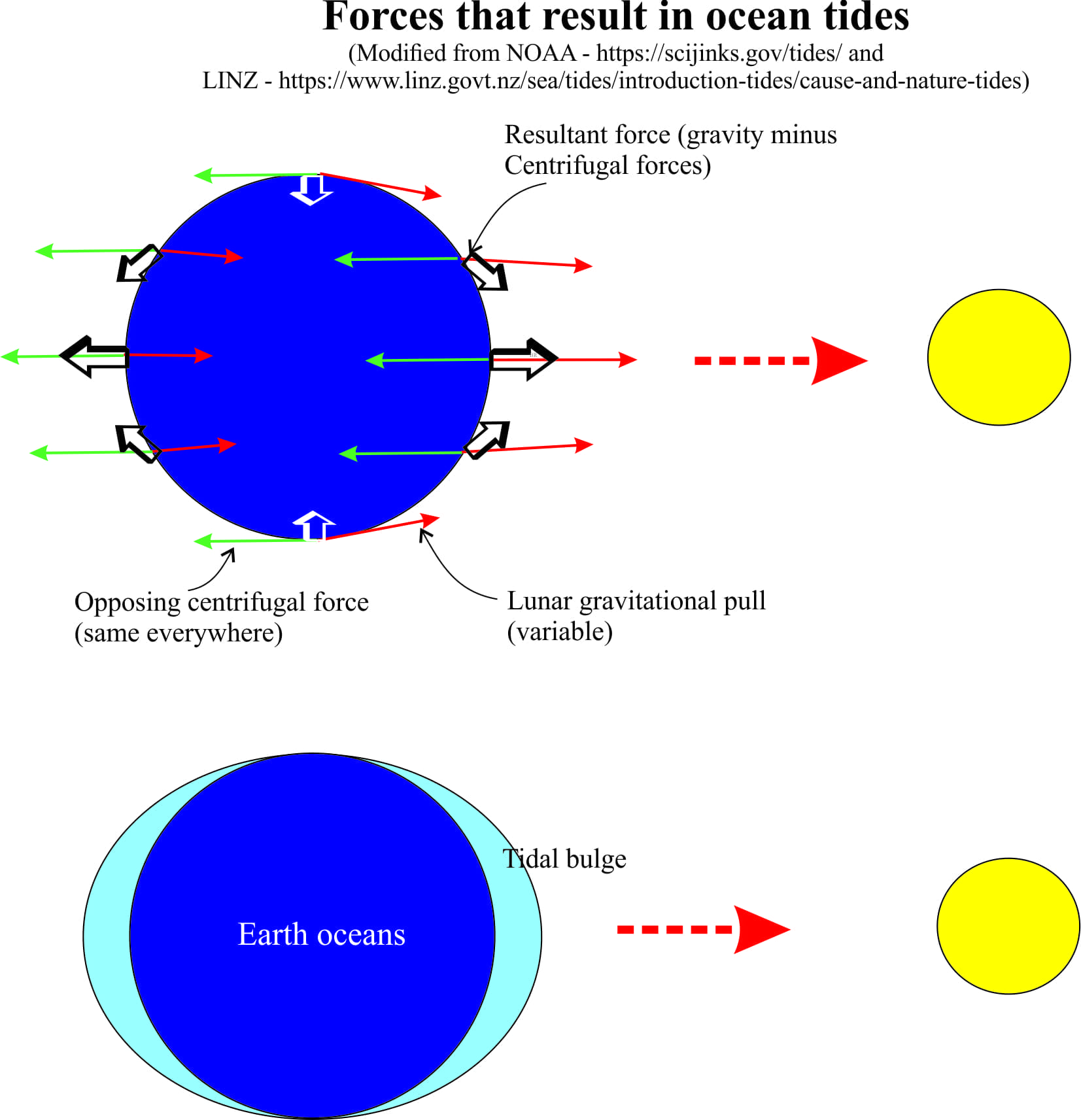
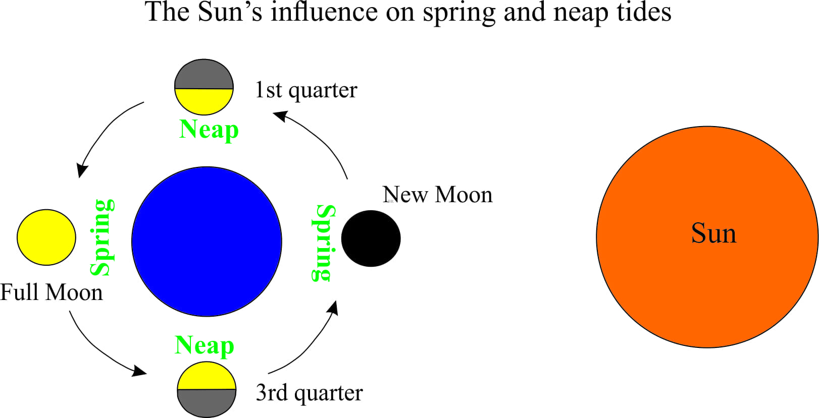
Astronomical tides: Gravitational forces acting on Earth, Moon and Sun are in a state of balance. Centrifugal forces provide the counterbalance between Earth and Moon; they are the same everywhere on Earth, but the Moon’s gravitational pull changes with distance; it is strongest on the side closest to the Moon, and weakest on the opposite side. Thus, at different points on the Earth surface, there is a slight difference between the two forces. The difference is not enough to upset the overall balance between Earth and Moon, but it is strong enough to create a bulge in the ocean mass; one on the side facing the Moon, the other on the opposite side of Earth. The bulges correspond to high tides. However, Earth rotates on its axis which means that different parts of Earth experience the bulge at different times. In this simple model, the bulges on opposite sides of the earth mean that there are two tides every 24 hours – semidiurnal tides. The Sun exerts a similar effect on Earth, but its influence on tides is about half that of the Moon. Nevertheless, the Sun’s gravitational force will reinforce that of the Moon during full and new phases of the Moon, resulting in spring tides; the opposite effect, neap tides occur when the gravitational forces are in opposition.
Astronomical unit: (AU) The distance between Earth and the Sun (about 150 million km). It is a convenient measurement unit for objects in the solar system where distances are measured in million of kilometres.
Aurora: High latitude winter nights are frequently interrupted by glowing, twisting and flickering curtains of light, commonly in shades of red, green, and yellow, but also blues. The polar lights (northern lights) are caused by charged particles from the sun interacting with Earth’s magnetosphere, specifically the Van Allen Radiation Belts. The charged particles interact with atoms of oxygen and nitrogen in the upper atmosphere (100 km + altitudes) – excited oxygen atoms produce red and green glows, while nitrogen produces blues. Aurora are common at latitudes above the Arctic and Antarctic circles; the northern events are the aurora borealis, and the southern aurora australis. Aurora have also been observed over the poles of Jupiter and Saturn.
Barringer impact crater: Barringer Crater, also known as Meteor Crater, is a 50,000 year old stony meteorite impact excavation on Colorado Plateau, Arizona. It is 1200 m diameter and 180 m deep, with a rim raised about 45 m above the surrounding plain. The bolide was probably 30-50 m diameter. Its current setting is desert but at the time of the impact the region was fully vegetated. It is classed as a simple crater, lacking a central peak and collapsed walls. Fall-back breccia contains shock metamorphic coesite and stishovite.
Barycentre: The centre of mass for two bodies, around which they rotate or orbit. Pluto and its near companion Charon are tidally locked about a barycentre that is 2,126 km from Pluto’s centre. The barycentre for the Earth-Moon system is 4671 km from Earth’s centre, which places it inside the Earth sphere. The barycentre for the Sun-Earth system lies within the Sun.
Baryonic matter: This is the matter we can see or detect, consisting of baryons, the general name for all the atomic particles in an atom nucleus; it is ordinary matter. The universe is composed of about 20% detectable matter – the rest is theoretically dark matter that is not visible or undetectable. Baryons that make up the planets, stars and other objects are largely uncharged (i.e. the atoms retain their electrons). However, most of the detectable mass in the universe consists of charged plasma that forms when electrons are stripped from their atoms, for example the charged particles in nebulae.
Bennu: Asteroid 101955 has peaked astronomers’ interest, in part because it appears to be quite porous and carbonaceous, and because late in the 22nd century there is a 1 in 2700 chance it will impact earth(the probability will change as we approach the year of closest approach). Its diameter is 492m. The OSIRIS-Rex satellite, launched in 2016, reached Bennu in 2018, successfully landed, and took measurements and samples that are currently winging their way back to Earth, with an ETA in 2023.
Blood moon: The moon appears red when it is full and in total eclipse.
Blue moon: There are normally 12 full moons observable from Earth. A blue moon is an additional full moon. They occur every 2-3 years, and can occur at different times of the year.
Bolide: A general name for large meteorites or comets that impact Earth or explode during entry to the atmosphere.
Callisto: The second largest of Jupiter’s moons, is the farthest of all the Galilean moons at 1,883,000 km. Its surface is peppered with white-centered, possibly ice-filled craters – hence its spotty white appearance. Most craters appear to be very old, indicating little internally forced change. Gravity surveys also suggest the possibility of a subsurface ocean. It has a very thin atmosphere of CO2. Callisto has the largest multi-ring crater in the Solar system – the Valhalla crater.
Caloris impact crater: Caloris Planitia (plain) on Mercury at about 1550 km diameter is one of the largest impact structures in the Solar System. It is surrounded by a mountain ring 1-2 km high. It is about 3.8 Ga and thus is relatively young with only a few superimposed craters covering the basin floor.
Carbonaceous chondrites: These are the most primitive meteorites known. The carbon content up to 3-5% consists of carbonates, organic matter, and traces of carbon-bearing minerals like diamond, graphite, and silicon carbide. They tend to be fine grained, with a matrix of clay, water, olivine, oxides, and sulphides. They appear to be low temperature meteorites. The organic content includes amino acids, amines, alcohols, and in rare cases, complex molecular nucleobases which are important ingredients for RNA and DNA. However, it is generally thought that the organic compounds formed abiotically.
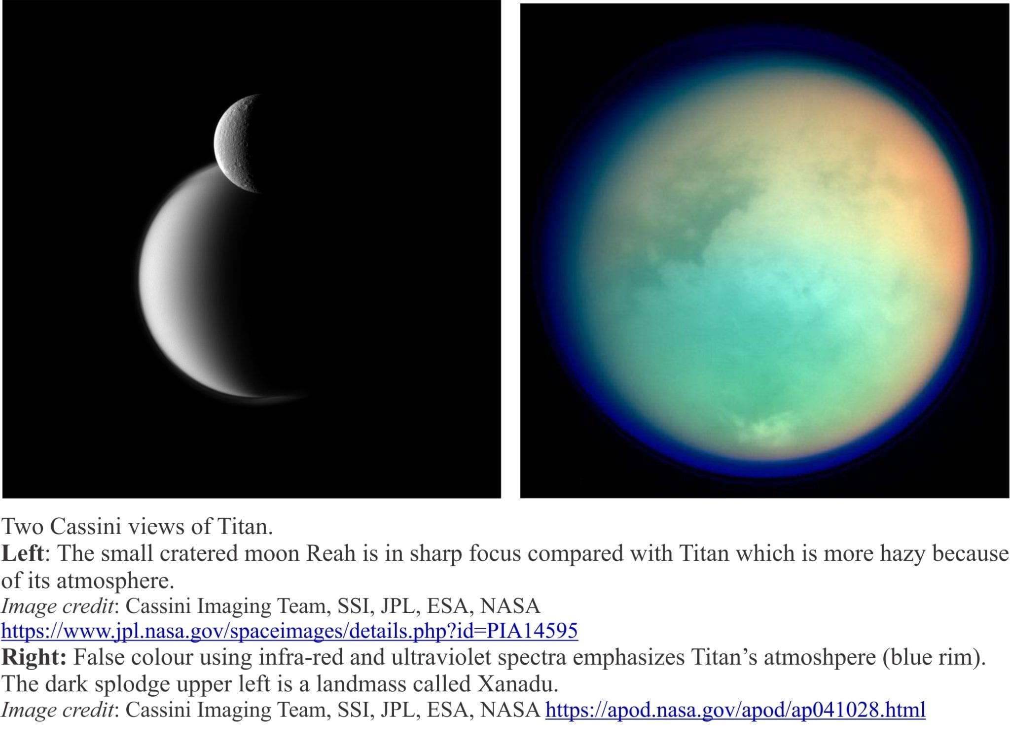
Cassini spacecraft: Launched October 15, 1997, Cassini’s primary tasks involved exploration of Saturn, its rings, and moons. The mission began with two gravity assists from Venus (1998-99), one from Earth later in 1999, and one from Jupiter in 2000. It completed 294 orbits of Saturn. Among its discoveries were details of the rings (consisting of ice and rock, some derived from the moons like Enceladus), active geyser plumes on the icy moon Enceladus, methane lakes and hydrocarbon sand dunes onTitan plus sending probe Huygens to Titan’s surface, 6 new moons, observation of storms, jet streams, and lightening on Saturn. Cassini’s grand finale was to plunge through Saturn’s atmosphere on September 15, 2017.
Celestial equator: The imaginary equator that projects from Earth’s geographic equator into space and through the celestial sphere.
Celestial poles: An imaginary line drawn through the axis of rotation (close to the geographic poles) that intersects the star Polaris, the North Star. The North Star appears to be stationary at night because it is so close to this axis. However, the North Star also moves with a period of about 25,000 years (the time taken to complete a cycle of movement across the sky). Thus, in 10,000 years the North Star will not coincide with Earth’s rotation axis.
Celestial sphere: For an observer on Earth, an imaginary sphere centred on the celestial equator, and having poles corresponding to the north and south celestial poles (that correspond to the poles of rotation). It is a useful device for determining astronomical time and position.
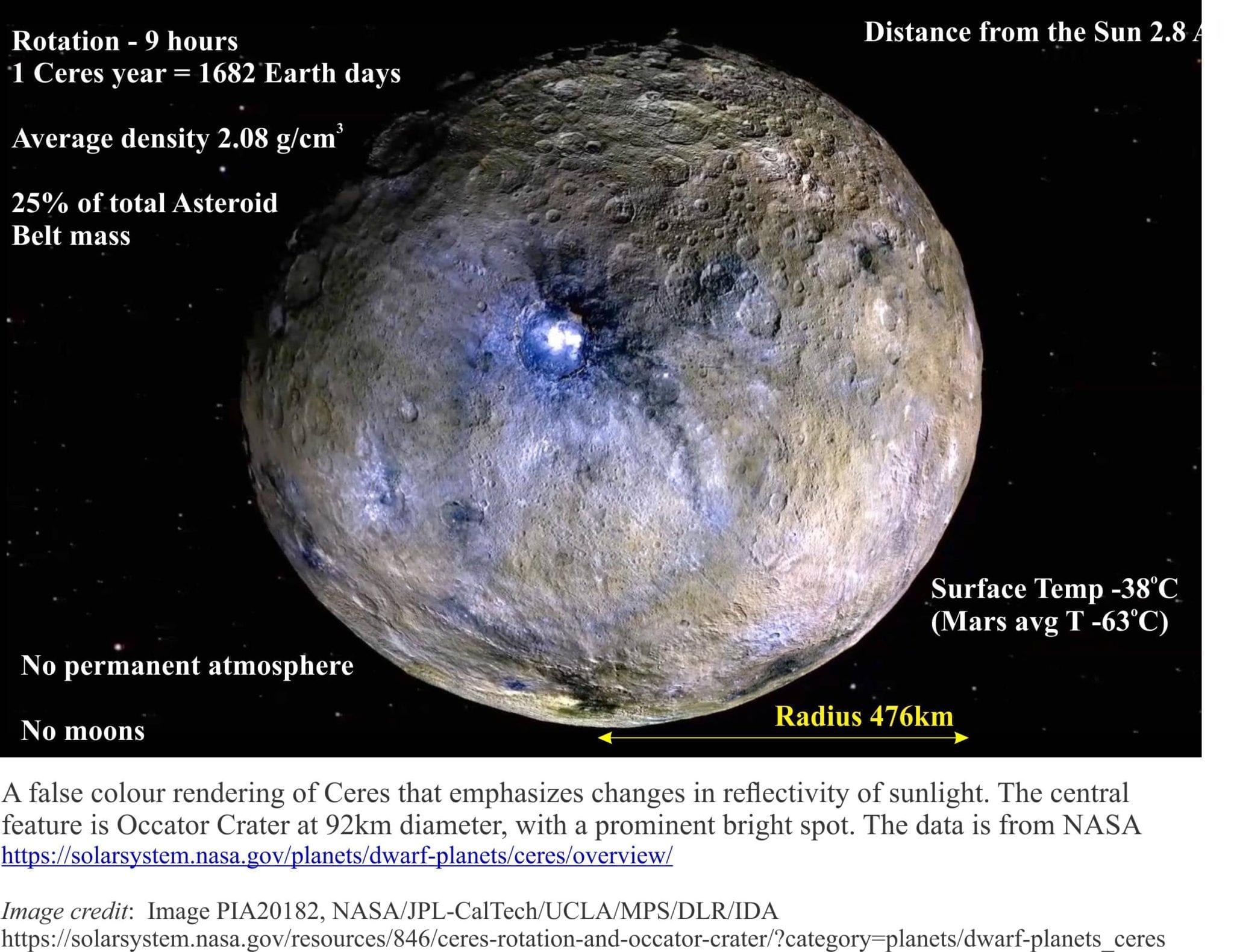
Ceres: Discovered by Giuseppe Piazzi in 1801. It was originally identified as an asteroid in the Asteroid Belt but in 2006 was elevated to the status of dwarf planet. Gravity measurements made by the satellite Dawn indicate a layered body having an average density of 2.08 gm/cc. The interior includes a salt-water layer that periodically leaks or erupts at Ceres’ surface, producing cryovolcanoes, the most recent being Ahuna Mons which is an almost circular cone about 20km wide at its base and 4000m high. Ice at the surface will sublimate and over time the cryovolcanoes degrade.
Chandrayaan-3 spacecraft: Launched by the Indian Space Agency, inserted into lunar orbit August 2023. It comprises a landing module and rover, tasked to measure chemical and physical properties at the lunar surface.
Chang’e-4 spacecraft: Launched December 8, 2018, China’s lander successfully alighted the Von Kármán crater on the far side of the moon. Communication with Earth is via a relay satellite. It has spectrometer and ground penetrating radar instruments.
Chang’e-5 spacecraft: Launched in 2020, This Chinese spacecraft released a land to the lunar surface December 6, 2020. The lander collected 1.7 kg of lunar soil and rock that was transferred to an Earth return module that landed in Mongolia. The samples are some of the youngest collected at <2 Ga.
Charon: The largest of five moons orbiting Pluto, it is an oblate spheroid at 606 km diameter and a density of 1.7 g/cc, marginally less than that of Pluto (2.03 g/cc). Its orbit is tidally locked to Pluto about a barycentre between the two bodies. It is probably composed of a mix of rock, methane, and nitrogen ice. Water ice has also been detected. The red colouration at the north pole is due to organic molecules.
Chelyabinsk meteor: An asteroid estimated at 17-20m wide, exploded about 22 km above the city of Chelyabinsk, Russia on February 15, 2013, producing a shock wave that broke thousands of windows, injured hundreds of people, and was recorded on seismographs on the other side of the world. It entered Earth’s atmosphere at 64,370 km/hour. Pieces of the meteorite were later found scattered over a wide area. Click here for video footage.
Chicxulub impact: The Chicxulub impact (north Yucatan Peninsula) coincides with the 65 million year old Cretaceous-Paleogene boundary (K-Pg) . This event has been strongly implicated in the extinction of dinosaurs, ammonites, and many other faunal and floral groups. The crater is not visible at the surface, but gravity surveys indicate a crater 180 km in diameter. Other lines of evidence for this event include:
An iridium anomaly at the KPg boundary in many parts of the world.
Tektites scattered more than 2500 km from the impact site.
Drilling near the imaged crater rim has intersected melt rock containing quartz crystals with shock lamellae.
Chondrites: Chondrites are a diverse group of meteorites composed mainly of olivine, pyroxene, metallic FeNi compounds, and traces of spinel and anorthite, all in varying proportions and textures. The most common textural attribute is spherical to highly irregular chondrules ranging in size from sub-millimetre to 10 mm and more. An important subgroup is carbonaceous chondrites. They represent the rapid crystallization from ultramafic igneous melts. They are thought to have formed early in the differentiation of the solar nebula.
67P/Churyumov-Gerasimenko: Comet 67P/Churyumov-Gerasimenko is a dumbbell-shaped, porous, fluffy-looking icy body who’s claim to fame was cemented in 2014 when landing craft Philae Lander touched down on the comet’s surface. Launched in 2004 by the European Space Agency consortium, the carrier satellite Rosetta journeyed for 10 years and more than 6 billion kilometres. Although Philae’s life was cut short, it did collect and analyse dust at the comet surface that revealed the presence of solid water-ice (expected), solid carbon dioxide (unexpected), phosphorous, and 16 organic compounds some of which had not been previously detected in comets (methyl isocyanate, acetone, propionaldehyde, and acetamide), plus the amino acid glycine.
Circumstellar disc: Discs of dust, gas, asteroids, comets, and in some cases dwarf planets that surround and rotate around a star, that are remnants of early protoplanetary discs and planet formation. The solar system has three main discs – the asteroid belt, the Kuiper belt and the Oort cloud.
Coesite: An ultra-high pressure polymorph of silica (quartz family) found primarily in meteorite impact rocks and in some eclogites (mantle rocks). It belongs to the monoclinic crystal system (quartz is trigonal), lacks cleavage, and has a density of 3.0 g/cm3 (quartz is 2.65 g/cm3).
Coma: The thin gas atmosphere surrounding a comet nucleus, consisting primarily of water vapour, CO2, ammonia, methane, and methanol. As the comet approaches the Sun, the gas plus dust particles from the comet surface form the characteristic comet tail.
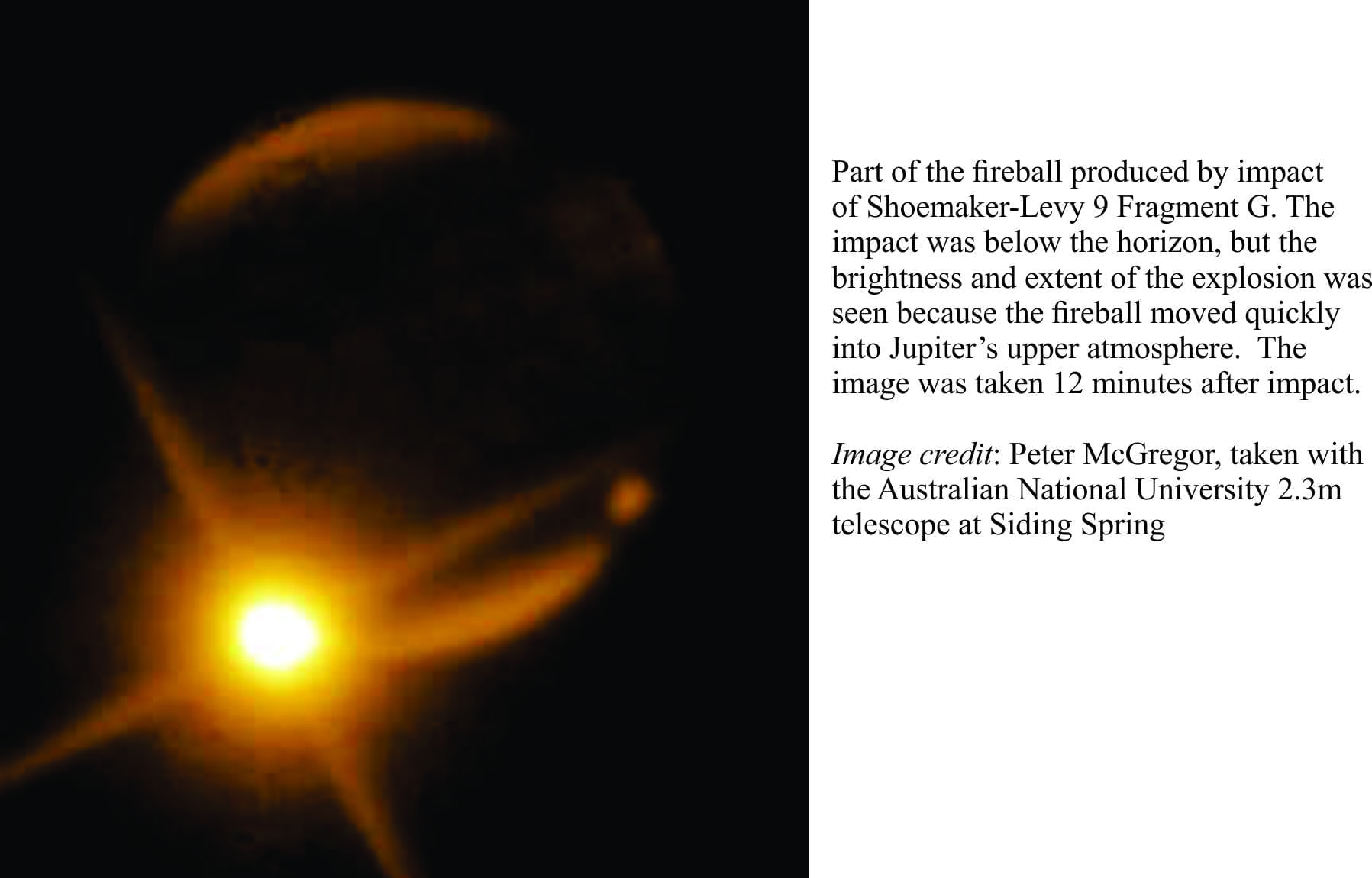
Comet: Large lumps of primordial ice, solid carbon dioxide, bits of rock, and traces of organic compounds that, it is hypothesized, originate from the Oort Cloud at the outer edge of our Solar System. Some that are dislodged from the cloud enter an elliptical orbit around the Sun. As they approach the Sun, heating produces a tail of ejected ice and dust; tails can be several million kilometres long. One of the most celebrated is Halley’s Comet that has an orbit period of 76 years. In one of those fortuitous circumstances for science, the 1994 impact of comet Shoemaker-Levy9 with Jupiter was predicted and the aftermath observed. Adding to the excitement, the European Space Agency’s Rosetta mission to comet 67P/Churyumov-Gerasimenko ended with the touchdown of landing craft Philae in 2014.
Comet classification: Based on the duration of their orbit around the Sun: short period comets take 200 years or less, long periods comets >200 years. Single apparition comets appear to make one orbit and then leave the solar system – they are thought to originate in other star systems.
Complex craters: Craters with diameters >10 km fall into this category if they also contain (Grieve & Therriault, 2012):
– A central peak of highly brecciated country rock that in some craters can rise 2 km and more above the crater floor.
– A peak ring in very large craters.
– Collapsed crater walls that result in terraced topography.
The central peak forms by two processes: flow of brecciated country rock from the walls into the middle of the crater; and rebound of the bedrock depressed during the initial impact.
Conjunction: When two objects in the sky appear close together to an observer. Examples include planets, moons, asteroids, stars. The closeness is only apparent.
Copernicus: Nicolaus Copernicus was a Polish mathematician and astronomer (1473-1543) who, as part of the Renaissance awakening of curiosity, challenged the Geocentric theory of planetary motion espoused by Aristotle, Ptolemy, St. Thomas Aquinas and the entire Catholic Church edifice, with a proposal that Earth and all its neighbouring planets orbited the Sun. Despite its rationale foundations (observations and mathematical calculations) Heliocentric theory was rejected by Catholic and Protestant authorities alike – ironically, Pope Gregory XIII used Copernicus’ theory to develop the Gregorian calendar in 1582. It would be another 100 years before Galileo resurrected the heliocentric principle.
Coriolis effects: The result of (fictitious) Coriolis forces apply to rotating, non-inertial systems like Earth. The forces act orthogonal to the direction of movement such that deflections are to the right of the direction of forward motion in the northern hemisphere, and to the left in the southern hemisphere. Coriolis forces are directly proportional to linear velocity on the same rotating body. Coriolis effects increase towards the poles of rotation and are zero at the equator. The deflections apply to ocean water masses (gyres), contourites, and to weather systems.
Corona: The Sun’s plasma atmosphere, that extends several 1000 km from the surface, eventually transforming to solar winds. Temperatures in the corona exceed 106o C, significantly hotter than the surface temperatures of about 5500oC.
Coronal mass ejection: Formed when a solar prominence breaks from the surface of the Sun. The ejection mass contains remnants of its former magnetic field; the mass expands as it travels outward at speeds from 250 to 3000 km/second. They can be accompanied by solar flares. They can create intense magnetic storms on Earth.
Cosmology: The study of the universe, its origin (big bang?), the formation of stars, black holes, galaxies, and planetary bodies. It is the conjunction of physics, astronomy, and other natural sciences, and metaphysics.
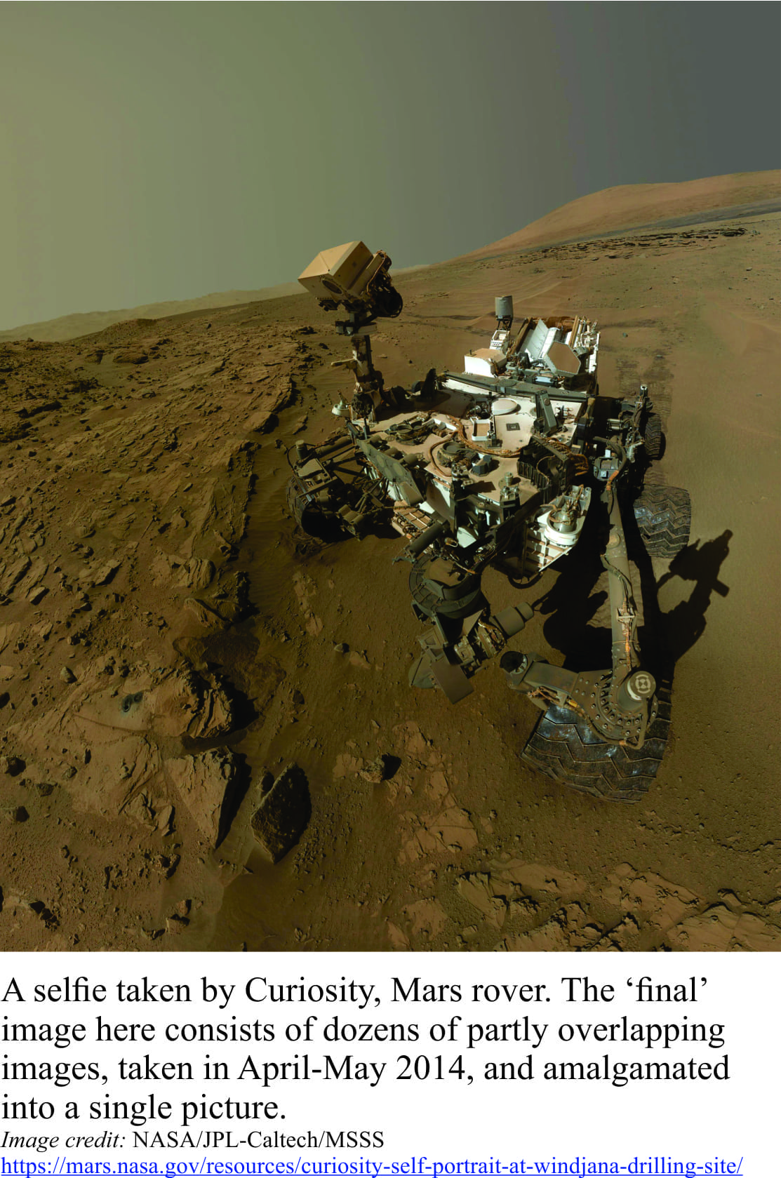
Curiosity Rover: The 6-wheeled Mars rover landed near Mt. Sharp on August 5, 2012. Its primary task was to look for past environmental conditions that might have supported life. It has analysed the chemistry of >40 soil-rock samples and taken over one million images of Mars surface. The instrumentation is designed to detect possible organic-biological chemical compounds. Analytical instruments include: Gas Chromatograph (analyses gas compositions); Mass Spectrometer (elemental analysis): Tuneable Laser Spectrometer (for detecting water vapour, biogenic or abiotic methane): Sample Manipulation System (organizes samples for low and high temperature analysis); Ovens (high temperature gas extraction).
DART: Double Asteroid Redirection Test. Launched Nov. 23, 2021, from the SpaceX Falcon 9 rocket. It impacted asteroid Dimorphos September 26, 2022, at about 6.6 km/s. The impact changed slightly the moon’s orbit around Didymos. The planned follow-up mission to observe the impacted surface is ESA’s Hera mission, to launch in 2024.
Declination: In astronomy, it is the angle of an object in the sky measured to the celestial equator, which corresponds approximately with Earth’s equator. The angle provides one coordinate equivalent to latitudes. The second coordinate required to fix the objects position is associated with time (GMT or UTC) that corresponds with longitudes. North of the equator the declination angles are positive; south of the equator they are negative. Astronomical declination is usually fixed to some distant star. For geographic measures declination is the difference between true and magnetic north from any point on Earth’s surface. Unlike the astronomical declination, the geographic declination changes as the magnetic pole migrates.
Deimos: The smallest of the two Martian moons, that orbits Mars every 30 hour. It has an odd, almost trapezoidal shape with a maximum dimension of 15 km. It is thought to be a captured asteroid.
Didymos : A binary asteroid. Didymos is the larger of the two (780 m diameter), Dimorphos is its moon (160 m diameter). Dimorphos was the target of a deliberate spacecraft (DART) impact on Sept. 26, 2022, to test the possibility of forcing orbital corrections of an asteroid that could impact Earth. Neither object is considered a near-Earth threat.
Dimorphos: The asteroid that was the target for NASA’s DART collision mission. It is about 170 m across and almost 11 million km from Earth. The planned collision on Sept. 26, 2022, at about 22,000 km/hr, was part of NASA’s program to investigate the possibility of forcing near-Earth objects from their trajectory. The evidence from this event indicates a change in asteroid shape (because of a loss of surface material) and orbital period around its binary partner Didymos.
Dione: Saturn’s 4th largest moon at 562 km radius, 377,400 km from its parent, and having an orbital period of 2.74 Earth days. Its density is 1.48 g/cc indicating a composition of mostly water ice and perhaps a rocky core. Surface temperatures average -186oC. The surface is cratered and cut by deep fractures. Its orbit is tidally locked to Saturn.
Dust devils (on Mars): Dust devils are common on Earth, and it seems on some parts of the Martian surface. They have been observed and measured in Jezero Crater by Perseverance rover. They are small convective vortices, or whirlwinds, usually less than 10 m wide, but up to a kilometre high. They are not associated with storm cells like tornadoes, but with warm air rising from the surface through cold air.
Dwarf planet: According to the IAU (2006), a dwarf planet “… is a celestial body that (a) is in orbit around the Sun, (b) has sufficient mass for its self-gravity to overcome rigid body forces so that it assumes a hydrostatic equilibrium (nearly round) shape, (c) has not cleared the neighbourhood around its orbit, and (d) is not a satellite”. Clearing its nearest neighbours would require a sufficiently large gravity field to attract and force collisions.
Eccentricity: Earth orbit is an ellipse where the degree of ellipticity changes by about 5% over periods of 100,000 years. Milutin Milankovitch (1879 – 1958) theorized that the change in orbit, although seemingly small, produces significant differences in solar intensity as earth moves closer or farther from the sun. It is one of the Milankovitch Cycles and is an important determinant of Earth’s climate. The shorter period Milankovitch obliquity and precession cycles are superimposed on the eccentricity cycle.
Eclipse: The partial or total blocking of light of one celestial object by the transit of another. A solar eclipse occurs when the moon’s orbit takes it between Earth and the sun – the moon’s disc is large enough to completely cover the sun. A total lunar eclipse occurs when Earth’s umbral shadow is cast on the moon creating a reddish blood moon. Eclipses are periodic and can be predicted.
Ecliptic: An imaginary plane containing Earth’s orbit, passing through the Sun. The orbits of the 7 other planets and minor planets lie in or close to this plane.
Ejecta: Shattered country rock and melt excavated during a bolide impact. Clast sizes range from very large blocks to dust and vapour. Some of this material fills the crater basin as fall-back breccia. The remainder is spread as an apron around the crater, generally becoming finer grained with distance from the impact site. Small fragments like tektites and spherules of glass melt can be distributed many 100s of km from the impact. Dust and vapour will spread much farther, particularly on planetary bodies that have an atmosphere. On Earth this would include aerosols that could, with large impacts, spread globally through the upper atmosphere.
Emirates Mars Mission: The United Arab Emirates mission, named the Hope Probe, to study the Martian atmospheric circulation and weather, and the dynamics of atmospheric loss to space, particularly oxygen and hydrogen. Launched July 2020. Planned duration is two years from arrival in February 2021.
Enceladus: Enceladus is an icy moon that orbits Saturn within its E ring. It is the 6th largest moon of Saturn with radius 250 km. Gravity and density modelling suggest it has rocky core, a liquid inner shell, and an icy crust that has a temperature of -201oC. Analysis of geyser-like plumes that erupt from fractures in the crust indicate the presence of water, derived from the subcutaneous liquid shell.
Ephemerides: Tabulated data giving the orbital position, time, and velocity for astronomical objects (planets, asteroids, comets) and satellites as observed on Earth. A data table is called an Ephemeris.
Equinox: Two days in a year that have an equal duration of day and night when the sun lies directly over the equator: Spring (vernal) equinox on March 21, and autumnal equinox on September 23. Cf, Solstice when the sun is farthest from the equator.
Erg: Ergs, also called sand seas, are vast areas of wind-blown sand, sculpted into sand dunes. Celebrated examples on Earth like the Sahara in North Africa, Atacama in Chile, and Taklamakan in China, occur in arid mid-latitude regions (between 30o-50o north and south). Much of the Martian surface is covered by sand and spectacular fields of sand dunes. Saturn’s moon Titan also has fields of dunes but in this case the sand is apparently composed of hydrocarbons.
Eris: A dwarf planet discovered 2005 at the edge of the Solar System. It appears to have an icey crust and rocky core. Mean radius is 1163±6 km (Pluto is 1188 km), a mean density of 2.43 g/cc that is 0.58 g/cc greater than Pluto. It has a single moon – Dysnomia. Its orbit at aphelion is about 97.5 AU, more than 48 AU farther away from the sun than Pluto.
Eta Aquariids: A well known meteor shower derived from material in Halley’s comet, usually seen in Aquarius (its radiant) April-May each year. On average 60 meteors per hour are visible at the peak display. They are some of the fastest meteoroids, travelling at 66 km/second (238,000 km/hour). cf. delta Aquariids.
Euclid telescope: An ESA mission, launched July 2023, its primary objectives to observe and measure dark matter and the expansion of the universe to determine the nature of dark matter, dark energy, and the underlying structure of the universe. The telescope images in the near infra-red and visible part of the light spectrum. It will orbit at Lagrange Point 2 in the Earth-Sun system. Named after the Greek mathematician who founded mathematics of geometry (300 BCE).
Europa: Jupiter’s moon Europa has an icy surface riven by fractures and ice rafts, but very few craters, all indicating a tectonically active, geologically young crust. Imaging of Europa’s magnetic field suggests that it has a subcutaneous liquid ocean beneath the fractured crust. Tidally generated heat maintains the liquid state of the inner ocean.
Exo-planet: The name given to planets beyond our Solar System. Several thousand exo-planets have been identified in other solar systems using land- and space-based telescopes. To date, over 5000 have been identified. Their physical and chemical characteristics are as variable as we can imagine. They range from massive Jupiter sizes to much smaller bodies, some warmer than Mercury or colder than Pluto, dense or light. But very few occupy a ‘Goldilocks Zone’ that might permit life forms.
Exosphere: An exosphere is the thinnest of atmospheres, where atomic and molecular collisions are few. On Earth, it is the uppermost atmospheric layer. On Mercury it is the only layer having an atmospheric pressure close to zero.
Faculae: Bright spots on the Sun surface, associated with strong magnetic fields, the number of which are related to darker sunspots.
Fall-back breccia: Shattered and brecciated rock generated during an asteroid impact, that is deposited in the associated crater, along the crater rim, or spread outward from the crater. The breccia includes intensely sheared rock fragments, minerals such as deformed quartz with shock laminae, and melt rock.
Filament: See solar prominence.
Fukang pallasite: (meteorite). Recovered in Fukang, China in 2000, weighing in at 1003 Kg, it is a rare example of an olivine-Fe-Ni meteorite. The Ni-Fe phase is mostly kamacite, the olivine Forsterite. It probably formed at the core-mantle boundary of a differentiated planetesimal hypothesized to be 400-680 km radius.
Gaia: From the ancient Greek, a Goddess of the earth. Gaia now commonly refers to a personalized version of Earth, the Gaia hypothesis, as a living, breathing thing that is self- regulating through complex interactions and interconnections among the atmosphere, hydrosphere, biosphere, and lithosphere.
Gaiaspace telescope: Launched by ESA 19 December 2013, tasked with mapping the Milky Way and the largely invisible halo beyond the visible limits of the spiral arms, including its effect on neighbouring galaxies like the Magellanic cloud star clusters. The data set so far is about 1.5 billion stars.
Galactic centre: The centre around which a galaxy rotates, and with it all the stars and their solar systems. The centre of the Milky Way is occupied by a super massive black hole that is about 4 million solar masses in size.
Galaxy: Galaxies are structured collections of stars (of all ages), dust and gas clouds, black holes, and dark matter, all glued together by gravity – the Milky Way spiral has about 400 billion stars. Their diameters are measured in 10s to 100s of thousands of light years. Four principle geometric configurations are: Elliptical clusters (no arms), spiral with arms, peculiar galaxies that are odd-shaped and probably formed by intergalactic collisions, and irregular types that are odd shaped and commonly lack arms (e.g., small clusters like the Magellanic Clouds).
Galilean moons: Four of the largest moons of Jupiter – Io, Europa, Ganymede, and Callisto, discovered by Galileo near the end of 1609. They can be observed with a decent pair of binoculars.
Galileo: Galileo Galilei (1564 –1642) was an Italian Renaissance polymath who made revolutionary discoveries on the motion of bodies (Earth-bound and planetary), and other astronomical phenomena using experiments and observations, frequently with equipment he himself constructed. He also built the first telescope. He was a renowned debater. His discoveries challenged the entrenched Aristotelian, Ptolemaic, and Church views of motion, culminating in his resurrection with proofs of the Copernican theory, that Earth and all the other known planets orbit the Sun. This work was published in 1632 “Dialogues on the Two Chief World Systems”, but in 1633 the Inquisition charged him of being “vehemently suspect of heresy” and he was forced to recant. His tomb and monument lie in Basilica Santa Croce in Florence.
Galileo spacecraft: An exploration satellite launched October 18, 1989 on a 14 year mission, 8 of them orbiting Jupiter. The mission began with a Venus flyby, acquiring radar images through Venus’ clouds. En route to Jupiter Galileo paid the first ever spacecraft visit to an asteroid, first Gaspra, then Ida, both in the Asteroid Belt. During its Jupiter sojourn, Galileo Europa’s subcutaneous ocean, active volcanism on Io including images of eruption plumes, and measurements of moons Ganymede and Callisto indicating liquid salt water in their subsurface layers. Galileo was also witness to the impact of comet Shoemaker-Levy 9with Jupiter from July 16 – 22, 1994. A small probe was also sent into Jupiter’s atmosphere to measure composition and pressure.
Ganymede: The largest of the Jovian moons, with a radius of 2631 km which makes it larger than Mercury and Pluto. It is the 3rd most distant from Jupiter of the Galilean moons, at 1,070,000 km. Ganymede’s density is … It is the only moon in the Solar System that has its own magnetic field and accompanying aurora. Surface temperatures range from -183 to -113 C. It has an iron-rich core, a rocky mantle, and an outer shell of ice and rock. The Ganymede surface is a mix of craters and grooves that may represent some kind of extension in the crust, or a response to bolide impacts.
Gas giants: Very large planets (several times the diameter of Earth) consisting of mostly hydrogen, helium, and lesser proportions of ammonia and methane. Rocky material, if present, is confined to the core. Core material may also be metallic hydrogen or helium. There is no rocky or solid, frozen surface, and the boundary between the planet surface and atmosphere is diffuse. The Jovian gas giants are Jupiter, Saturn, Uranus, and Neptune. All four have orbiting rings. All four have moons, some of which are rocky.
Gaspra 951: The first asteroid visited by the spacecraft Galileo, October 29, 1991. It has an oblong shape with dimensions 18.2 x 10.5 x 8.9 km. It orbits within the Asteroid Belt, and is probably a fragment from some earlier collision.
Geminids: One of the most active meteor showers derived from the asteroid 3200 Phaethon, usually peaks mid-December every year. Discovered 1862. It is seen in the constellation Gemini (its radiant), hence the name.
Geocentric model of the universe: This is the Earth-centred model around which the Sun, the planets and stars revolve. Notable proponents included Aristotle, Claudius Ptolemy (2nd C BCE), and St. Thomas Aquinas (1225? – 1274). In western theology and philosophy, the model held sway until the mid-16th C; in popular constructions it was represented by armillary spheres. The model assumed doctrinal importance for the Roman Catholic Church to the extent that anyone questioning it was deemed a heretic. The model was seriously challenged by Nicolaus Copernicus (1473-1543) and a bit later by Galileo, both of whom were required to recant their views.
Geographic pole: Geographic poles are points that we have defined by constructing lines ofLongitude that converge at the north and south poles – also referred to as true north-south. The projection of these poles onto the celestial sphere intersect at the celestial north (North Star) and celestial south poles.
Geologic Atlas of the Moon: Produced by the USGS at scales from 1:5,000 to 1:5,000,000. They are free to download.
Gibbous moon: The stage of the Moon’s illumination when it is more than half illuminated but not full. There are both waxing and waning gibbous moons each month.
GMT: Greenwich Mean Time, established in 1884 is the prime meridian (longitude) to which all international time zones are referenced.
Goldilocks zone: The orbital distance of a planet from its sun where atmospheric temperatures and pressures are in the ‘habitable zone’, and where vapour pressures are sufficient for water to remain liquid. Earth exists in this zone.
Gosses Bluff – Tnorala: Remnants of an Australian, Northern Territories, 142.5 million year old impact structure. The residual crater is 5 km diameter, but originally was probably about 20 km. The bolide, possibly a comet, is hypothesized to have been about 600 m across. The structure is sacred to the Western Arrernte Aboriginal people, and is designated a conservation reserve.
Gravitational constant G: Upper case G is a the mathematical constant in Newton’s Laws of gravity, that expresses the force of gravity between two bodies F = (G. m1 ). (m2. R-2) where m1 and m2 are the body masses, and R is the distance between the centre of each body. The units of G are Newtons . m2 . kg-2. G has the universal value of 6.67 × 10⁻¹¹ N. m2. kg-2. The acceleration due to gravity (lower case g) can be calculated from this function as g = G.m . R-2. On Earth g = 9.81 m.s-2. On Mars g = 3.72 m.s-2, and on Jupiter g = 25.8 m.s-2.
Gravity assist: (colloquially called ‘slingshot’). Space craft designed to explore the distant regions of the Solar System require the energy to do so. The initial energy is derived from the launch rocket. However, additional momentum is needed to get to the various planets and this is derived from orbits around Earth, the Sun, and other planets. For example, Voyager 2, launched in 1977, passed by Jupiter (transmitting data and images), increasing in speed during the approach. At a certain point during its orbit, Voyager’s speed and momentum were sufficient to change it to a trajectory that would take it to Saturn. The same process was used at Saturn to put Voyager on course for Uranus, then again from Uranus to Neptune, and finally from Neptune to interstellar space.
Great Blue Spot: The other, more recently discovered spot on Jupiter, it is a patch of intense, localised magnetic fields.
Great Red Spot: The most iconic structure on Jupiter, the Great Red Spot is a massive storm. It was probably first identified in 1665. It spins counter clockwise, rotating every 4.5 Earth days. The storm is fed by jet streams. Recent measurements by Juno spacecraft indicate the storm drafts extend at least 500 km deep. Measurements of its long axis since the late 1800s indicate that it has lost half its size over the last 100 years, a decrease of about 900 km/year. Its long axis is presently about 16,500 km long.
Greenhouse effect: Greenhouse gases help modulate atmospheric temperatures. On Earth, this is accomplished by small amounts of water vapour, carbon dioxide, methane, nitrous oxide, and more recently certain industrial hydrocarbons in our atmosphere. The most important are CO2 and CH4. Both molecules absorb heat at different infrared frequencies, that also are different to the frequencies absorbed by water vapour. Note that water vapour does not cause increased atmospheric temperatures – in this case the proportion of H2O increases or decreases because of changes in temperature caused by other processes. Despite their low concentrations, CO2 and CH4 provide the balance in atmospheric temperatures required to sustain life. In contrast, runaway greenhouse conditions on Venus have resulted in atmospheric temperatures about 450oC and atmospheric pressures about 92 time that on Earth. Aerosols and volcanic dust also moderate the greenhouse effect.
Habitable Zone: The distance of a planet or exoplanet from its star where conditions are such that water can exist on its surface in liquid form. The conditions require a relatively narrow range of temperatures and atmospheric pressures. Also known as the Goldilocks Zone. Whether an exoplanet is potentially habitable will also depend on many other factors, such as atmospheric composition, and the intensity of incident UV or cosmic radiation.
Halley’s Comet: One of the better known and spectacular comets visible from Earth, discovered in 1758 by Edmond Halley, has a period of 75-79 years. It will next appear around 2061.
Heliosphere: The boundary between the Solar wind and interstellar space that extends about 120 AU from the Sun. It protects the Solar System from cosmic radiation originating elsewhere in the Milky Way.
Hesperian Period (Mars): The period on Mars from 3.7 Ga to 2.9 Ga. Asteroid bombardment had lessened, but volcanism persisted, with sulphate-bearing aerosols and acid rain blanketing the planet. This was a period of extensive sulphate mineral precipitation and sedimentation, and significant atmospheric cooling because of reduced incident solar energy. However, local, short-lived heating caused by asteroid impacts seem to have produced massive flood surges.
HiRISE (High Resolution Imaging Science Experiment) The most successful, high resolution camera to orbit Mars, HiRISE (High Resolution Imaging Science Experiment) images Martian landscapes in the visible and infrared light frequencies. It is capable of resolutions at 30 cm per pixel, or about one metre. HiRISE is one of 6 instruments on the Mars Reconnaissance Orbiter that arrived on the scene in 2006. It can rapidly process large numbers of images which means we can witness geomorphic processes almost in real time. The lead investigative institution is Lunar and Planetary Laboratory at the University of Arizona.
Hubble telescope: Launched from Space Shuttle Discovery in 1990, it orbits Earth at 535 km altitude, with a complete orbit every 95 minutes. It was designed (and upgraded) to image our Solar System and beyond at light frequencies from ultraviolet to infrared. As of October 2022, it has acquired more than 1.5 million images. It has revolutionized our observations and understanding of space.
Hydrostatic equilibrium (HE): If the gravitational forces generated by a celestial body (directed to the centre of the body) are balanced by internal pressures that are directed outward, then the body is said to be in hydrostatic equilibrium. It applies to stars, planets, and even galaxies. Maintenance of this equilibrium requires that the body assumes a spherical geometry, although most are oblate spheroids because of gravitational forces exerted by neighbouring bodies. For example, Earth has a slight equatorial bulge because of the gravitational attraction exerted by the Moon. HE is one of the requirements for a body to be designated a planet, or dwarf planet.
Hyperion: (a child on Gaia and Uranus) The potatoe-shaped moon of Saturn that looks like a sponge. Discovered 1848, its maximum length is 410 km. The surface is pocked by deep craters. Density is less than 0.5 kg/m3 and hence may be composed of very porous ice. The average surface temperature is -180oC.
Iapetus: Saturn’s 3rd largest moon, 3,561,300 km distant, with a radius of 730 km. Its density is 1.2 g/cc and composition predicted to be mostly water ice with some rock. It is tidally locked to Saturn. Its leading hemisphere (the one facing into the direction of orbital motion) has very low albedo (very dark) while its trailing hemisphere has very high albedo.
Ice rafts: Sheets of ice that have been broken by extension and contraction, where rafted fragments are thrust against and over one another. On Earth, rafting develops during successive periods of freeze and thaw of thick polar sea ice. Ice rafting has also been observed in the outer crust of Jupiter’s moon Europa, and Saturn’s moon Enceladus.
Ida 223: 243 Asteroid Ida was also visited by spacecraft Galileo on August 28, 1993. It is the first asteroid found to be orbited by its own moon. It has a cratered, regolith covered surface. It is probably composed of silicates.
Impact breccia : Breccia formed by intense fracturing and shock metamorphosed rock during a hypervelocity impact, that also has a clastic matrix (an important difference from impact melt rock). Breccias may also include fragments of impact melt rock. It includes impact foot-wall breccia (e.g., from crater margin collapse) and fall-back breccia. Shock-deformed crystals are an important component. The term is broadly synonymous with suevite.
Impact crater: A bowl-shaped depression caused by the excavation and ejection of rock or ice during a bolide impact. Ejected material is pushed or falls back forming raised crater rims. The rims of large craters can collapse. Some ejecta spreads much farther in a ray-like distribution. Finer dust and aerosols are also spread afar, particularly on planets that have an atmosphere. Large craters commonly have central mounds or peaks that form by a combination of rim collapse and rebound of rock beneath the crater immediately following impact. Three basic crater morphologies are recognised: simple, complex, and peak ring or multi-ring types. The moon has more than 106 craters, many of them superimposed one on the other. Mars is estimated to have at least 300,000. On Earth, the number of confirmed craters is about 190 – we have received as many impacts as other planets in the solar system, but surface degradation by weathering and structural dismemberment, burial by sediment, and crustal recycling (plate tectonics) have rendered them indecipherable or removed them from the rock record.
Impact gardening: The process where a planetary surface is reworked multiple times by meteoroid impacts. It is commonly manifested as brecciated regolith where individual rock fragments may be derived from several impact events.
Impact melt rock: Melt rock formed by heat generated during a hypervelocity impact. Melt rock may be clast-rich, clast-poor, or completely free of clasts (clasts generated by the impact), and they can be further subdivided into glassy or varying degrees of crystallinity. Note that melt rocks containing clasts should not be confused with impact breccias that may contain clasts of melt rock.
Impact velocity: The velocity of a bolide at impact depends on its initial velocity (in space), the gravitational potential of the planetary body, and the density of an atmosphere (if present). When a bolide hits Earth’s atmosphere, it’s a bit like hitting a brick wall – most will burn up (meteors). The minimum impact velocity on Earth is 11.2 km/second which is equal to the escape velocity. The average impact velocity is 18 km/sec (64,800 km/hour), but can be as high as 53 km/sec (190,800 km/hour). Bolide approach velocities range up to 72 km/sec (259,200 km/hour). Lunar impact velocities tend to be slower because gravity is only 16.5% of that on Earth.
Impactite: A broad term that the has been defined as “all rocks affected by one or more hypervelocity impact(s) resulting from collision(s) of planetary bodies” (Stöffler and Grieve, 2007). The term encompasses impact melts, impact breccias, and shocked rocks. The latter includes shock metamorphic structures like shatter cones, and shock-deformed quartz and other crystalline phases.
Ingenuity Helicopter: A small dual blade helicopter that arrived on Mars attached to Perseverance Rover, making its first flight on April 19, 2021. It completed 72 flights (the mission was for 5 flights), completing 128.8 flying minutes, covering 17.0 km, and reaching altitudes of 24.0 m. It ceased operation on Jan. 18, 2024, probably during a crash landing.
InSight lander (Mars): Launched on May 5, 2018, InSight landed on a flat plain named Elysium Planitia on November 26, 2018. It had two primary tasks: to record seismic events that would improve our understanding of Mars’ internal structure, and to measure heat flow. The heat flow probe failed. Power failure brought a close to the mission on December 15, 2022. Over 1300 seismic events were recorded including one at magnitude 4.2 that was probably the result of an asteroid or comet impact. The seismic events provide the basis for estimates of layer thickness and density: the (probable) molten core has an 1,890-1,790 km radius. The outer crust (top of the lithosphere) is 30-72 km thick.
International Astronomical Union (IAU): A non-governmental organisation dedicated to the promotion and safeguard the science of astronomy. It also works to define fundamental astronomical and physical constants, and nomenclature.
International Space Station (ISS): One of the more successful, international, cooperative space ventures, involving at least 15 countries, spearheaded by Europe, USA, Russia, Canada, and Japan. It was constructed with modular components while in orbit, between 2008 and 2011, and has been continually occupied since 2000. It orbits at 400 km altitude at a speed of 25,000 km/hour, completing an Earth orbit every 90 minutes. Astronauts living on the station conduct experiments in the physical sciences (e.g. fluid dynamics in low gravity, materials science), life sciences (e.g., biomedical, biotech), remote sensing, technology development (e.g., robotics), and education.
Interstellar comet-asteroid: An object that originates outside the solar system and is not bound to a star by gravity. The first interstellar asteroid identified was the wierdly-shaped ʻOumuamua in 2017. In 2019 the comet C/2019 Q4 (Borisov) entered our solar system and is considered a potential interstellar object – it’s velocity is about 150,000 km/hour which is fast enough to escape the Sun’s gravitational pull and leave the solar system.
Interstellar space: Defined as the region beyond the influence of a star’s magnetic field and solar wind (charged particles). In our solar system it is beyond the Heliosphere.
Io: The third largest moon of Jupiter, it is the only one with active volcanism – over 400 eruptive centres have been mapped. Io’s density is 3.5g/cm3 and modelling suggests it has a core of iron or iron sulphide, an inner shell of solid and molten rock, and a crust of sulphur and extruded silicate rock. Its atmosphere is mostly sulphur dioxide. Io’s elliptical orbit brings it to about 420,000 km from the gas giant. The resulting gravitational forces produce huge tides such that the surface bulges up to 100m. These tidal forces generate enough heat to melt rock and sulphur. The Galileo Explorer mission imaged active eruption plumes extending more than 300 km above the surface.
Iron meteorites: These metallic meteorites are composed of iron and nickel alloys, principally kamacite, an isometric FeNi crystal with about 92% iron, and Taenite, a slightly harder, isometric FeNi crystal form with 25-40% Ni. Both these crystal forms are only found in meteorites. Crystal growth commonly produces Widmanstätten bands. The meteorites are thought to have originated from the cores of planets that were fragmented by collisions during the early differentiation of the solar nebula. Cf. Stony-iron meteorites and stony meteorites.
Iridium anomalies: Stony meteorites commonly contain elevated concentrations of platinum group elements compared with those normally found on Earth. One of these elements, Iridium (Ir), is an important indicator of ancient bolide impacts. It was first discovered in 1980 by Walter and Luis Alvarez in a thin clay layer at the Cretaceous-Tertiary boundary in Italy. Ir concentrations in the clay are about 500 parts per billion, compared with values around 0.1-0.3 ppb in Earth rocks. Similar anomalies were subsequently in clays of the same age in other parts of the world. The Alvarez’ concluded that the Ir spike was caused by fallout from an asteroid impact – the Chicxulub impact. Iridium anomalies have since become a standard indicator of ancient bolide impacts.
J Webb telescope: Launched December 25, 2021, the new telescope will augment Hubble with longer wavelength and more sensitive infrared views of the universe. It is capable of imaging in marvelous detail some of the oldest galaxies in the universe, and the birth of stars and planets in dust clouds and nebulae. Unlike Hubble, J Webb will orbit the Sun in concert with Earth, maintaining about 1.5 million km from and in direct line-of-sight with Earth (Earth lies between the Sun and the J Webb). The side facing the Sun will be at 85oC; the side opposite -225oC. The principal collaborators are NASA, ESA, and the Canadian Space Agency.
Jezero Crater: A 45 km diameter crater in the Isidis Planitia region of Mars, and the landing site of Perseverance Rover. Remnants of an ancient delta prograded from the crater margin – these sedimentary rocks are one of the prime objectives for the Perseverance project, in particular looking for sedimentary structures that provide evidence of ancient flowing water, and any chemical-sedimentary evidence that might indicate ancient life.
Jovian rings: Saturn’s rings were first observed in 1610 by Galileo. They consist of rock, ice, and dust. Some of the Saturnian moons also reside with the ring system. The rings around Uranus were discovered in 1977, those around Jupiter in 1979, and Neptune in 1989. Saturn’s rings are a few metres thick and extend about 130,000 km above the planet equator. The moon Enceladus orbits Saturn within Ring E and appears to be shedding new material to those rings. Dust and small fragments that are ejected from the inner moons during meteor impacts, are added to Jupiter’s rings.
JUICE: Jupiter Icy Moons Explorer, The European Space Agency’s spacecraft that will examine the Jovian icey moons Europa, Ganymede, and Callisto. Launched April 14, 2023. It will be sling-shot to Jupiter from an Earth-Venus orbit. It is expected to arrive July 2031. The final part of the JUICE mission will involve orbits of Ganymede ranging from 5000 km to 200 km, after which it will impact with the Ganymede surface.
Juno spacecraft: Launched August 5, 2011, arriving at its first orbital position around Jupiter on July 4, 2016. Its orbits are highly elliptical extending from the outer limits of the powerful Jovian magnetosphere to its cloud tops. The mission has been extended from its initial 5 years. Juno’s science includes the Jovian physical, chemical and magnetic structure, cloud and storm dynamics, the rings, and flybys of several Jovian moons.
Jupiter’s Trojans: A group of asteroids and planetesimals that occupy the same orbit as Jupiter. There are two main groups that librate around Jupiter’s stable Lagrange Points L4 and L5. There are several hypotheses that relate their origin to early planetary collisions, captured planetesimals from the giant planet zone, or captured from the primordial Kuiper Belt. See Bottke et al., 2023. Open Access.
K-Pg boundary: Formerly called the K-T, or Cretaceous-Tertiary boundary, the Cretaceous-Paleogene boundary marks the extinction event at the end of the Mesozoic, that saw the demise of dinosaurs and many marine invertebrate groups, like the ammonoids. Two explanations for the extinction event are: the Chicxulub impact at about 65 Ma (the most popular explanation), and volcanic CO2 emissions from the Deccan Traps that caused abrupt and dramatic atmospheric heating, ocean acidification, and mercury toxicity.
Kuiper Belt: A torus- or donut-shaped region of large and small icy bodies that lies outside the orbit of Neptune. Pluto lies within the Kuiper Belt. Fragments and planetesimals in the belt are probably remnants from the formation of the Solar System. It is different to and lies inside the Oort Cloud.
Lagrange points: When a body is in stable orbit around a larger mass, (e.g., the Earth and Sun) there is a balance between the gravitational forces (between both bodies), and centrifugal forces acting on the smaller orbiting body. In any two body system, there are five locations on the orbital plane where both forces are equal – these are the Lagrange Points. These points are useful for spacecraft because only minor adjustments are required to maintain a stable orbit. For example, the J Webb Telescope orbits Earth at Lagrange Point 2 (L2) in the Earth-Sun system, at a distance of about 0.1 AU. In this case, L2 is on the outside of the straight line joining the Sun and Earth (L1 lies between the Sun and Earth). However, L1 and L2 are not completely stable positions and J Webb Telescope requires minor adjustments every 23 days.
Latitude: Also called parallels. Imaginary lines that describe the angular location north or south of the equator. Zero latitude corresponds to the equator. Ninety degrees north and south correspond to the north and south geographic poles respectively. Lines of latitude describe small circles that intersect lines of longitude (meridians) at right angles. The tropics of Cancer and Capricorn represent the most northerly and southerly latitudes respectively (23.43°) where the sun can be positioned directly above an observer. The Arctic and Antarctic circles at 66.56° north and south respectively. The Antarctic circle represent the limit where the the sun will not set during the southern summer solstice or rise during the winter solstice. The reverse timing applies to the Arctic circle.
Leading hemisphere: For a tidally locked satellite, it is the face that is forward, towards the direction of orbital motion.
Light pollution: The ever-increasing problem of incident and reflected light generated by cities and orbiting satellites interfering with the operation of Earth-bound telescopes.
Light year: A unit of length used for astronomical distances, usually from Earth to stars and galaxies. Light travels through a vacuum at 299,792 km/second (186,282 miles/sec). Thus, the distance traveled in one year is 9.46 x 10¹² km (5.87 x 10¹² miles). The nearest star Proxima Centauri is ~4.25 light-years away.
Lithophile elements: One of the Goldschmidt classification groups of elements that readily bond with oxygen. This means they tend to be concentrated in Earth’s crust and probably the crusts of other rocky planets – common examples are Na, Ca, Mg, Si, Al, K. as well as some of the transition metal elements like Fe, Mn. cf. siderophiles.
Longitude: A measure of a line on the surface of the Earth that gives a position in degrees as east or west. Imaginary lines of longitude converge at the two poles. Lines of longitude describe great circles. Longitude also denotes time, where one hour is equivalent to 15o east-west. The zero line of longitude, the prime meridian set internationally in 1884, is located at Greenwich, England. East of the prime meridian time increases by 1 hour for every 15o; west it decreases by 1 hour. Thus, 12 noon at Greenwich corresponds to 12 hours later at 180o east from Greenwich.
Love waves: Seismic surface waves that propogate like S waves but only generate side to side ground movement; they are also attenuated in fluids. They are slower than P and S body waves. Cf. Rayleigh waves.
Luminosity: A measure of an object’s brightness expressed as energy or power output (e.g. watts). In astronomy, it is usually expressed with reference to a standard known luminosity, such as the Sun. It is related to absolute magnitude of a star by the expression:
M = -2.5Log (Observed luminosity/Standard luminosity)
Lunar core: Precise thickness of the lunar crust is uncertain because of ambiguities in the seismic data and models of rotation. Seismic S waves are strongly attenuated which means that either the entire core is liquid, or that it has a liquid outer shell. Recent models tend to favour a small liquid core ranging from 300 to 350 km diameter, surrounded by a liquid shell 90 to 220 km thick. All evidence indicates an iron-rich core. Core density is probably in the region of 7.8 kg/m3.
Lunar crust: Thickness estimates vary from 30 km to 43 km depending on the gravity or seismic model used. Thickness values for the far side are about 15 km greater than the near side. The average bulk density is 2550 kg/m3. The most common rock types are basalt and anorthosite.
Lunar datum: The datum used in geodetic surveys, based on the lunar average radius. The datum is an imaginary sphere of radius 1737.4 km.
Lunar eclipse: When the moon moves into Earth’s shadow, such that Earth lies exactly between and in line with the Moon and Sun. A total lunar eclipse can only occur on a full moon. A partial eclipse occurs when Earth’s umbral region covers part of the moon. A penumbral eclipse occurs when the more diffuse penumbra shadow covers part of the moon – this type of eclipse is usually more difficult to observe.
Lunar mantle: Precise thickness of the lunar mantle is uncertain because of ambiguities in the seismic data. However, from the base of the lunar crust to about 1200 km P wave velocities are consistently about 6.8 km/s and S wave velocities about 4.5 km/s. Seismic S waves are strongly attenuated below this depth which may indicate partial melting in the lower mantle or outer core. Deep Moonquakes range from 700-1100 km depth. The mantle is probably silicate-rich, composed of olivine- and pyroxene-rich rocks, with relatively consistent densities of 3.4 to 3.5 kg/m3.
Lunar mare: (singular maria, from Latin for ‘seas’): Extensive plains covered in basalt over about 15% of the lunar surface, most filling large craters from very old impacts. Most mare occur on the Earth side of the moon. They formed between 3.9 and 3.1 billion years ago. Basalt melts were probably generated at each impact. The eruptions were mostly effusive; evidence in the form of glass globules in lunar regolith suggest that fire fountains were important eruptive mechanisms. Wrinkling of lava flow tops has also been imaged. Samples collected by the Apollo missions show vesicularity of some basalts, indicating degassing during eruption.
Lunar near side / far side: The near side of the moon is visible from Earth; the far side is never visible from Earth.
Lunar Reconnaissance Orbiter: A lunar satellite operating since September 2009, tasked to produce detailed topographic and geodetic surveys of the lunar surface, identify possible future landing sites, measure surface temperatures and UV albedo, particularly across the lunar polar regions.
Lunar Seismic Profiling Experiment: An active seismic experiment at Apollo 17 station (1972) using explosive charges, and four geophones – three in a 100 m sided triangle about a central geophone. The aim was to profile the lunar structure to several kilometres depth.
Lunar stratigraphy: The recognition of distinct geologic periods on the Lunar surface is based primarily on superposition of craters and ejecta blankets, and the products of volcanism, augmented by a small number of radiometric dates from Apollo mission samples. There are 5 main periods:
Pre-Nectarian: 4.533 – 3.920 Ga.
The beginning of the Nectarian (3.920 – 3.850 Ga) is taken as the age of Nectaris impact with its ejecta blanket providing a useful stratigraphic marker. A period of intense bombardment.
The Imbrium Period (3.85 – 3.20 Ga) Bombardment intensity continued, beginning with the Imbrium impact. There was significant basaltic volcanism.
The Eratosthenian, 3.20 – 1.10 Ga; the lower age limit of this period is less precise because it is based on the erosional morphology of craters (i.e., erosion by other impacts), whereas the upper age limit is based in part on how fresh and bright the excavated rock appears.
Copernican Period, 1.10 Ga to present. The Copernican crater near the southern edge of the near-side in the Imbrium Basin, is 93 km diameter and has spectacular, bright rays extending to 300 km from the impact site.
Lunation: A lunar month measured as the time between two new moons. Equals 29 days, 12 hours, 44 minutes, and 2.8 seconds.
Maat Mons: One of the largest volcanic edifices on Venus, with a peak elevated about 5 km above the surrounding plains. Recent vent activity has been identified on a shield volcano that is part of the Maat Mons complex, from radar images acquired by the Magellan spacecraft in 1990-1992.
Magellan spacecraft: A NASA mission, launched 1989 from Space Shuttle Atlantis, arrived in Venus orbit August 1990. Its primary task was to image the Venus surface over four years using radar mapping to penetrate Venus’ thick cloud cover. Almost 100% of the surface was mapped, in addition to gravity measurements over about 95% of the planet.
Magellanic Clouds: Two of the closest galaxies to the Milky Way, they are relatively small, irregular clusters of stars and nebulae. The Large Magellanic Cloud (LMC) is about 160,000 light years away; the Small cloud (SMC) about 200,000 light years. They are thought to be satellites of the Milky Way. They are always observable with the naked eye in the southern hemisphere because they are close to the south celestial pole.
Magnetic field: Earth’s magnetic field is generated by a hot (4000-5000oC), fluid-like, iron-nickel rich outer core that moves slowly around a solid iron inner core. The magnetic field is forced into a tear-drop shape by solar winds, with the head of the ‘drop’ towards the sun (extending about 65,000 km), tapering over 600,000 km away from Earth. The magnetic field protects us from harmful components of the solar spectrum, like X-rays. The field has North and South poles that occasionally reverse over geological periods of 104 -105 years. The field intensity also waxes and wanes.
Magnetic pole: Points north and south where lines of equal magnetic intensity converge. The strength of Earth’s magnetic field depends on the movement of the fluid iron-nickle outer core around the solid iron inner core. Because of this movement, the magnetic field also moves. Thus, the magnetic poles traverse back and forth across their respective polar regions. The magnetic polarity can also reverse – and has done multiple times in the geological past.
Magnetic reversal: Reversal of Earth’s magnetic field has occurred many times, and over the last few million years this has happened about every 200,000 to 300,000 years. The last reversal took place 780,000 years ago; this is called the Brunhes-Matuyama Reversal. Reversals are recorded by iron-bearing minerals in volcanic and sedimentary rocks where the minerals act as tiny magnets – the direction of polarity (i.e. magnetic N and S) is locked in mineral at the time of lava solidification or sedimentation, and this remnant magnetism can be measured.
Magnetosphere: The region of space around a planet where the magnetic field interacts with the solar wind. The impact of the solar wind on the Sun-side of Earth sets up a bow wave, or shock wave that is relatively close to Earth. On the opposite side of Earth, the magnetosphere streams to a point 10s of 1000s of kilometres away. The magnetosphere is responsible for limiting the impact of cosmic rays that are harmful to life and would also strip away Earth’s atmosphere.
Manicouagan impact structure: A well preserved, Late Triassic impact crater in northern Quebec, Canada, about 90 km diameter and outlined by a moat-like lake that surrounds the central uplift. It has been dated at 215 million years. The crater occurs within a Precambrian metamorphic-igneous terrane. The central uplift is composed of anorthosite that is surrounded by impact breccia and a 55 km wide melt sheet of differentiated monzonite and monzodiorite that are up to 1.4 km thick. Shock metamorphic structures include breccia, shatter cones, and shock-deformed quartz and feldspar crystals. The bolide was probably on the order of 5 km diameter. The impact may be implicated in the end-Triassic extinction event.
Mare (plural maria): Broad, relatively flat impact plains underlain by extensive basalt lava flows and lava tubes (these are the large dark splodges visible from Earth). Some are multi-ringed structures. They were originally interpreted as oceans or seas by enlightenment astronomers, hence the name – mare). Most formed from catastrophic impacts 3.1 to 3.9 billion years ago.
MARS 2: The Soviet Union vehicle that crashed while attempting a landing on Mars in 1971.
MARS 3: The second of two attempts by the Soviet Union to land a vehicle on Mars. MARS 3 landed successfully on December 2, 1971 but only functioned for about 20 seconds and did not transmit any data.
Mars Express: The first European Space Agency Mars orbiter, launched in 2003 and still operating. It has provided detailed images of the Martian surface, images that have been used to characterise landing sites for future landing craft. It discovered ice water in the polar ice caps, possible lakes beneath the ice caps, and has provided valuable information on atmosphere composition and weather conditions.
Marsquake: Analogous to earthquakes and moonquakes, caused by fault-related tectonics within the martian crust and mantle (low frequency events), plus numerous very small magnitude events caused by thermal contraction and expansion at the surface. The only records of marsquakes are from Mars InSight lander and its seismometer SEIS experiments from 2019 to 2022.
Mars Reconnaissance Orbiter: Arriving in 2006, the primary mission of this spacecraft was to explore the role of water on the early Martian surface. It began orbiting in 2006. It has 6 cameras and analytical tools: HiRISE imaging camera (High Resolution Imaging Science Experiment); CTX (wide angle imaging to give c9ntext to HiRISE; MARCI (Colour Imager to monitor clouds and dust storms); CRISM (Compact Reconnaissance Imaging Spectrometer for Mars); MCS (Mars Climate Sounder) to monitor atmospheric changes; SHARAD (Shallow Radar) to see below the Martian surface.
Martian canals: In 1888 Italian astronomer Giovanni Schiaparelli produced a detailed map of Mars showing features such as seas, islands, and other landmasses, and a network of ‘canali’, or channels. Canali was misinterpreted in English as canals, and with it the connotations of intelligent life on Mars entered popular belief. We now know that many of Schiaparelli’s canali are actual channels, gullies, and canyons that have remarkably similar morphologies to water-worn features on Earth.
Mesosiderites: A type of stony-iron meteorite that consists mostly of brecciated fragments of crustal basalt, gabbro, and pyroxenite, plus crystals of olivine and orthopyroxene, and less commonly plagioclase. The matrix consists of finer grained cataclastic fragmentals and impact melt. Mesosiderites are thought to have formed from reconstituted fragments during asteroid collisions.
Meteor: Another name for shooting star, it refers to a meteoroid that burns upon entry to a planetary atmosphere. Cf. meteorite.
Meteor shower: A display of shooting stars that occurs when Earth’s orbit takes it through the remnants of a comet or asteroid. Most meteoroids are small bits of rock and dust. They originate from a radiant – a particular point in the sky. There are over 100 well documented showers, and many more suspected. For example, the Aquariid shower is caused by a pass though remnants of Halley’s comet from 390BC. Other prominent showers are the Perseids that can be seen every year and are derived from the tail of Comet Swift-Tuttle, and the Geminids derived from asteroid Phaethon. Meteor visibility depends on the timing in the night sky, and on the Moon’s phase because of light interference. The American Meteor Society publishes a calendar of shower events.
Meteorite: A meteor that impacts a planet’s surface. There are three main types: iron meteorites, stony-iron meteorites, and stony meteorites. There are several important subdivisions of these three, such as chondrites, carbonaceous chondrites, and pallasites.
Meteoroid: Rock and ice fragments that move through space, ranging in size from dust to massive asteroids. Cf. meteor.
Milankovitch cycles: Milutin Milankovitch was a Serbian mathematician and engineer (1879-1958) and a contemporary of Alfred Wegener. He developed mathematical models to explain the variations in solar insolation that is an important driver of earth’s climate. He was particularly interested in the periodicity of glaciations. Milankovitch theory describes three kinds of orbital cycle: Precession, Obliquity and Eccentricity, each of which is influenced by gravitational interactions between the earth, sun and moon, and to a lesser extent the planets. Milankovitch cyclicity is commonly invoked to help explain changing climates and sea levels.
Milky Way: The galaxy in which we reside is a barred spiral with two primary arms extending from the end of a central bar of stars. It is about 100,000 light years wide (9.5 x 10¹⁴ km) and contains a billion or more stars. Our solar system is located about 2/3 of the way (26,000 light years) from the Galactic Center in one of the arms. Our Sun and the Solar System rotate about the galactic centre, completing a circuit every 250 million years. The nearest large galaxy is Andromeda (M31), about 2.5 million light years away. There are two smaller clusters nearby – the Greater and Lesser Magellanic Clouds.
Mimas: One of the smallest of Saturn’s moons, it consists almost entirely of ice. Mimas stands out because one of its craters, Herschel Crater, is 130 km diameter, about a third of Mimas diameter. The crater walls are 5 km high and a central peak that is 6 km high. The impact forming this structure must have come close to completely fragmenting the moon.
Minor Planet Center: This is the official organization that considered the identification and naming of minor bodies in the Solar System (dwarf planets, asteroids, comets, moons, near Earth objects). It operates under the auspices of the International Astronomical Union (IAU) and is funded by NASA. It is also responsible for publication of ephemerides.
Moonquake: Seismic tremors and upheavals from quakes, meteoroid and artificial impacts. The equivalent of an Earthquake.
Murchison meteorite: A carbonaceous chondrite that was observed to explode of as it entered Earth’s atmosphere on 28 September, 1969, over the eponymous Australian Victorian town. Several bits of the meteorite were found. Hundreds of organic compounds have been identified including amino acids, macromolecules, nitrogen- and sulphur-bearing compounds. All the organic compounds are considered to have formed abiotically, but such compounds may have provided the biochemical seeds for the beginning of life of Earth. Very small grains of silicon carbide have been dated at 7 billion years – almost 2.5 billion years older than the Solar System.
NASA: The National Aeronautic and Space Agency was formed in July 29, 1958, in part a response to the successful launching and orbit of the USSR’s Sputnik satellite. It’s primary aim was to “accelerate work on human and robotic spaceflight, and is responsible for scientific and technological achievements that have had widespread impacts on our nation and the world.” For a complete history check out the various commentaries and videos in the link above.
Nasa shuttle era: The five shuttles beginning with Columbia in 1981, and continuing successively with Challenger, Discovery, Atlantis and Endeavour, provided launch and recovery trips to space for 135 missions, the program ending in 2011. Missions included satellite recovery and repair, experimental work, and was instrumental in the construction of the International Space Station. Each shuttle was capable of a glide landing on a runway.
Near Earth objects (NEO): Asteroids and comets having orbits that approach Earth to within 1.3AU units (about 200 million km) are considered a potential risk. The risk of impact is based on probability. There are three categories based on bolide size: <140 m (low risk), 140-1000 m (low to moderate risk), and >1000 m (disastrous). Near Earth Objects with orbits that bring them to within 0.05AU to earth (7,500 km), and are large enough to survive entry, are classified as Potentially Hazardous Objects.
Nebula: Vast interstellar clouds of dust and gas (mostly hydrogen). Many are the remnants of stars that have exploded at the end of their life, but the clouds then become nurseries for new stars. The Crab Nebula, about 10 light years across and 6500 light years away has several nascent stars; likewise the Eagle Nebula that is up to 70 light years wide and contains the iconic Pillars of Creation.
New Horizons mission: The NASA mission to fly-by Pluto, its moons, and beyond to the Kuiper Belt, launched January 2006. The fly-by began July 14, 2015, and the Kuiper Belt dumb-bell shaped object Arrokoth on January 1, 2019. Its closest approach to Pluto was 7,800 kilometers. En route it flew by Jupiter’s moon Io, Europa, and Ganymede, including a gravity-assist by Jupiter in February 2007. The spacecraft is about 8.8 billion km from Earth as of December 5, 2023.
Noachian Period (Mars): The period on Mars from 4.1 Ga to 3.7 Ga. Asteroid bombardment continued. There were vast outpourings of basaltic lava from volcanic centres like the Tharsis region, including the massive edifice of Olympus Mons. Ocean masses may have persisted into this period. Many of the drainage channels and associated features also formed at this time, presumably because of precipitation. Sediment derived by these processes would have been transported to basinal regions. Most of the crossbedded sandstones and laminated mudrocks imaged by various Mars rovers date from this period.
North Star: The northern hemisphere star Polaris lies on an imaginary line projected from Earth’s rotational poles. Thus, the position of the star in the night sky remains the same. It is also called the celestial star and lies on the celestial sphere.
Nuclear fusion: A natural multi-step process in the core of stars where hydrogen is converted to protons (positively charged plasma) that in turn transforms to helium under intense heat (15 million degrees C) and pressure. The process is initiated when two protons fuse together. One of the protons transforms to a neutron, forming deuterium that in turn collides with another proton to form Helium-3 (2 protons + 1 neutron). The process is complete when two He-3 nuclei collide to form helium-4 (2 protons + 2 neutrons). Each fusion step releases heat and light.
Obliquity: Obliquity is the combined effects of axial precession and ecliptic precession that cause earth’s tilt to move between 21.5o and 24.5o (the tilt angle is measured against the ecliptic). It is one of the Milankovitch cycles. The time to complete one tilt cycle is 41,000 years. The changes in obliquity can impact the severity of Earth’s seasons. At the lowest tilt the sun is distributed a bit more evenly so that seasonal variations are likely to be more clement. At the highest tilt, seasonal variation is likely to be more dramatic. Earth’s tilt is presently 23.4o and is on the decreasing part of the cycle.
Occultation: In astronomy, an occult occurs when observation of a body is prevented by a second body passing between them. Common examples are solar eclipses or when one of the planets is eclipsed by the moon.
Odysseus lander: The first commercial landing on the Moon on February 22, 2024, on the relatively steep slope of crater Malapert A, South Pole region. The landing itself was a success, except one of the legs broke on rough terrain and the lander fell over but continued to send data and images. It was launched aboard a SpaceX Falcon 9 rocket.
Olympus Mons: The largest known volcano in the Solar System and part of the Tharsis Montes volcanic region on Mars. It has the iconic shield form, 624 km in diameter, 25 km high, a caldera crater 80 km in diameter, and a 4-6 km high scarp on its outer rim.
Oort Cloud: The Oort Cloud contains the most distant bodies in the Solar System at distances ranging from 2000 to 200,000 AU (3.2 light years). It contains mostly icy bodies described as planetesimals. Icy bodies are distributed through the cloud in two regions: an inner disc, and an outer sphere – both are located beyond the heliosphere which means the Sun’s gravitational influence is very weak to non-existent. Some comets visible from Earth may have been dislodged from the cloud.
Opposition: In astronomy, the situation when two celestial bodies are in exactly opposite positions in the sky. When viewed from Earth, a full moon is opposite the Sun with Earth approximately in the middle. Opposition can only be observed for planets outside Earth’s orbit. Thus, Jupiter is in opposition when it rises in the east as the sun sets in the west – again Earth is in the middle.
Orbit: The path described by a body that moves around a (larger) parent body. Orbits are commonly elliptical in planetary, star, and satellite systems. Orbits are stable when gravitational forces are balanced by centrifugal forces.
Orbital period: The time taken for a body to complete one rotation around its parent. In planetary systems it refers to planet-star, planet-moon, asteroid/comet -sun, and in some cases comet-planet systems.
Orbital resonance: A resonance between satellites occurs when the difference in their orbital periods can be expressed as an integer. Good examples of this relationship are three of the Jovian Galilean moons – Io, Europa, and Ganymede, whose orbital period ratios are 4:2:1 respectively. This relationship means that each moon influences the gravity response of the other two moons and the degree of eccentricity of their orbits.
OSIRIS-Rex satellite: (Origins, Spectral Interpretation, Resource Identification, Security, Regolith Explorer) Launched September 8, 2016, it reached Bennu in 2018 spending a year mapping the surface. It successfully landed and collected measurements and samples, departing for Earth May 10, 2021. ETA at the Utah Test and training Range (near Salt Lake City) is September 24, 2023.
ʻOumuamua: A cigar-shaped, interstellar, asteroid-like rock that entered our solar system at about 20o to the ecliptic, was discovered October 2017. It was sling-shot away from the Sun at about 137,000 km/hour, fast enough to break free of the Sun’s gravity and take it out of the Solar System.
P & S waves (seismology): Seismic body waves generated by an impulse (earthquake, TNT, meteor impact) that travel through Earth from the energy source. P waves push and pull materials in the same direction as the propagated waves (also called compressional waves). S waves, or shear waves produce sideways motion – motion at right angles to the propagation direction. Shear waves do not travel through liquid. P waves travel fastest (up to 7.97 km/sec in upper mantle rocks) and are the first to appear on a seismogram. See also Surface waves.
Pallasites: One of two types of stony-iron meteorites that consist of olivine crystals encased in the FeNi metal compounds Kamacite and Taenite. They may represent a more differentiated part of the cores of ancient planets.
Parsec: The distance of a body from the Sun, calculated when the angle between the Sun and Earth, subtended by the body is 1 arcsecond (1/3600 of a degree). The distance between Earth and the Sun is 1 AU. Therefore, a parsec corresponds to 3.086 x 10¹³ km, or 3.26 light years.
Partial solar eclipse: When the Moon’s penumbral shadow traverses Earth when the moon is between Earth and the Sun – i.e., the umbral shadow does not fall on Earth cf. total eclipse.
Passive seismic experiments: A common method of earthquake and impact investigation on Earth, the method was used for the first time on another planetary body during Apollo 11 in 1969, and subsequent Apollo missions until the experiments were terminated in 1977. More than 13,000 significant seismic events were recorded including shallow and deep moonquakes, meteoroid impacts, artificial impacts, and diurnal thermal events. A passive seismometer was also installed during the InSight program on Mars from 2018 to 2022.
Paterae: From Latin meaning dish-shaped, a depression, or crater. Used by early astronomers to describe such features on planetary surfaces, like Mars, that subsequently have been identified as volcanic craters and calderas. They are also known on Jupiter’s Moon Io.
Peak ring craters: These form in very large craters where the central peak collapses and brecciated rock flows outward to form a blocky, roughly concentric ring. They are far less common than simple or complex craters. The only known example on the moon is the 900 km diameter Mare Orientale. (Grieve & Therriault, 2012)
Penumbra: The region of diffuse shadow outside the umbra.
Perigee: The closest distance of the Moon from Earth during its elliptical orbit. Cf. apogee
Perihelion: The closest distance from the Sun (or any star) of an orbiting body. The term coined by Johannes Kepler applies to planets, comets and asteroids that have elliptical orbits around a star. Etymology – Helios, the Greek Sun God. Cf. Aphelion
Perijove: The position on a satellite orbit that is closest to Jupiter’s center. Cf. Apojove, Perigee.
Periodic comet: Comets having orbital periods less than 200 years. The classification is indicated by a ‘P’ in the comet name. The link above is to the University of Maryland/NASA list of periodic comets (more than 800 of them).
Perseids: A prominent meteor shower that peaks mid-July to early September. It originates from the constellation Perseus (its radiant), from comet 109P/Swift-Tuttle.
Perseverance Rover: Launched July 30, 2020, landing in Jezero crater February 18, 2021. The site was chosen because it contains exposures of ancient delta – river deposits. Its primary mission was to explore the Geology, Astrobiology (possible ancient life),Sample Caching (collect and package samples for collection by future missions – 38 sample tubes available), look for possible sites for future human missions, and technology development using the Ingenuity Helicopter.
Phases of the Moon: The constantly changing positions of the moon as it is viewed from Earth, describes a cycle beginning with a new moon when the Moon lies between Earth and the Sun, and ending with the full moon when Earth lies in the middle. In the northern hemisphere a waxing moon will become increasingly illuminated from right to left, and a waning moon decreasingly illuminated from right to left (i.e., it is illuminated on the left). The opposite rule applies in the southern hemisphere. The phases in a full lunar cycle (29.5 days) for the northern hemisphere are: a waxing crescent (illuminated on the right); 1st quarter; waxing gibbous; full moon; waning gibbous (illuminated on the left); last quarter; waning crescent; new moon.
Phobos: The larger of the two Martian moons, discovered in 1877, it is very close to the Mars surface, orbiting about every 8 hours. Its orbit is decaying at about 1.8 m/100 years. Its largest dimension is 27 km. The surface is pockmarked by craters and groove-like structures that are hypothesized to have formed by tidal forcing.
Planet: The 2006 IAU definition “A planet is a celestial body that (a) is in orbit around the Sun, (b) has sufficient mass for its self-gravity to overcome rigid body forces so that it assumes a hydrostatic equilibrium (nearly round) shape, and (c) has cleared the neighbourhood around its orbit.” The expression ‘cleared the neighbourhood’ refers to the gravitational attraction and impact of asteroids, comets, and dust that reside nearby.
Planetary differentiation: The process of separation of elements and minerals into distinct compositional layers. Dense minerals will tend to sink (gravitational differentiation). Fully differentiated rocky planets and planetesimals commonly have Fe-Ni cores, surrounded by silicate-rich mantle layers; olivine is a common mineral in mantle rocks. Accumulation of lighter silicates such as quartz will occur in outer crustal layers. Differentiation may begin during initial planetary accretion, but will continue with partial melting of mantle rocks, and magmatic processes in the crust.
Planetary orbits, axial rotation, obliquity, moons, distance from the Sun, and rings: Information in this chart has been sourced from multiple websites.
Table of planetary orbits, axial rotation, obliquity, moons, distance from the Sun, and rings:
Planetary surface temperatures, pressures, and atmospheres: Information in this chart has been sourced from multiple websites.
Planets and dwarf planets: their surface temperatures, surface pressures, and atmospheres
Planetary radii, densities and gravity: : Information in this chart has been sourced from multiple websites.
Table of planetary radii, densities and gravity
Planetesimal: Accretion of gas and dust during the early stages of planetary nebula evolution, eventually leads to bodies, or planetesimals with gravitational fields large enough to draw in their nearest neighbours. The planetesimals may be broken up by asteroid bombardment (the resulting fragments subsequently available for accretion to other planetesimals), or they may continue to accrete leading to fully fledged planets. Larger planetesimals may be capable of generating enough internal heat to cause partial melting, and differentiation of a core, inner shell, and an outer crust. Planetesimals are regarded as the building blocks of planets. Theoretically, many of the asteroids in the Asteroid Belt are planetesimals left over from accretion in the early nebula.
Precession: Precession describes the Earth’s wobble as it spins on its axis of rotation. The time taken to complete a single wobble cycle is 19,000 to 23,000 years. Earth is an oblate spheroid with its longest diameter at the equator – precession is caused by this equatorial bulge. It has the shortest period of the three main Milankovitch cycles. Precession cycles are superimposed on obliquity cycles.
Pre-Noachian Period: The period on Mars from 4.5 – 4.1 billion years ago, from its accretion to the formation of differentiated crust, and hypothesized cooling and condensing of its atmospheric water vapour to form oceans and lakes. It was also a period of intense asteroid bombardment.
Protoplanetary disc: A (flattened) disc of gas (probably >90%), dust, asteroid-like bodies and other planetesimals surrounding a young star. Gravitational attraction eventually forms larger planets, the number and composition of which depends on the disc mass and composition. As a planet grows, it eventually develops its own gravitational field and continues to attract disc material. Hubble and JWST telescopes have imaged several protoplanetary discs around exoplanets. Cf. Circumstellar discs.
Proxima b: An exoplanet closest to Earth at about 4.25 light years, discovered in 2016. It orbits the red dwarf Proxima Centauri, the small star that orbits the double stars in the Alpha Centauri system. Its orbit is 0.0485 AU from its star, and although probably in the potentially ‘habitable zone’, it is bombarded by UV radiation intense enough to strip most atmospheric molecules from its surface.
Pseudotachylite: A dark, fine-grained rock, commonly identified by its glassy groundmass and quench textures, that can be found along fault planes or as veins associated with bolide impact shock metamorphism. Pseudotachylite composition is usually similar to the country rock it intrudes and is derived by partial or complete melting of the host rock. The veins commonly contain breccia.
Radian: An angular measure commonly used in mathematical expressions involving rotation and moving bodies, for example angular velocity. 2π radians is equivalent to 360o.
Radiant: The point in the sky from which meteor showers originate and radiate from. The radiants for most showers coincide with constellations, from which the showers commonly get their name (e.g., the Perseids in Perseus).
Rayleigh waves: Seismic surface waves that produce a rolling ground motion with vertical and horizontal components of movement. They are slower than P and S body waves. Cf. Love waves.
Regolith: A general term describing the products of physical and chemical weathering, resulting in a veneer of soil and granular material including breccia. Regolith associated with meteoroid impacts will usually contain melt glass and evidence of shock metamorphism. Examples of extraterrestrial regoliths have been observed and/or sampled on the Moon, Mars, asteroid Bennu, and comet 67P/Churyumov-Gerasimenko, and some other planetary moons.
Retrograde motion: Motion of a body that is opposite the so-called normal or prograde motion. All planets orbit the sun counter-clockwise relative to the North Star; most planets also rotate on their axes in the same direction, except Venus and Uranus that rotate clockwise or retrograde. The asteroid Bennu also has a retrograde spin.
Rhea: Saturn’s second largest moon, with radius 764 km, orbiting about half a million kilometres from its parent. Its density is 1.23 g/cc, and gravity 0.264 m/s2, and with relatively high albedo indicates that its shell is probably ice water and core a mix of ice and rock. Surface temperatures range from -174oC to -220oC. The orbit is tidally locked to Saturn; orbit period is 4.5 Earth days.
Rocky planets: Planets that have a solid silicate or iron core, molten or solid shells, and a solid crust. In our Solar System this includes Mercury, Venus, Earth, and Mars. Pluto is a combination of ice and rock. Some of the Jovian planets have moons that are rocky, or are combinations of rock, ice, and liquid layers.
Rotational poles: Two points where the axis of rotation of a spheroid intersects the surface. On Earth the poles correspond closely to the geographic poles.
S1000a: The first major meteoroid impact on Mars recorded by the InSight seismometer SEIS on September 18, 2021, for which there was visual confirmation of its crater from before-and-after images taken by HiRISE orbiter. The crater was 130 m diameter. The impact produced a marsquake of magnitude 4.0-4.1, that produced a recorded P wave that was diffracted by Mars core-mantle boundary (Duran et al., 2022).
Sedna: A dwarf planet and the most distant object in the Solar System, it is 90 AU from the Sun (about 12.9 billion km). It is 3 times more distant than Pluto. Sedna has a highly elliptical orbit. It was discovered 14 November 2003 by Caltech and Yale astronomers. The name is derived from the Inuit god of the sea.
SEIS: The broad-band frequency seismometer deployed by InSight lander on Mars surface at Elysium Planitia, 2019. More than 1300 high and low frequency, tectonic and impact quakes were recorded over its four years of operation.
Seismic coda: Seismic wave scattering can produce a kind of ringing, or echo effect that is referred to as seismiccoda (coda is a term used in music composition to indicate a repeated theme). It is an important contribution to recorded lunar and Martian seismicity, probably because of intense fracturing in the shallow crust, that can mask other important signals.
SETI Institute: Search for Extraterrestrial Intelligence. The SETI Institute was incorporated in California on November 20, 1984 and began operations on February 1, 1985. It began as a NASA project, but has expanded to look for life and intelligent life in other solar systems. NASA and the National Science Foundation remain SETI partners, in addition to private and philanthropic funding.
Shatter cones: Shatter cones are a distinctive structure formed by high pressure events such as asteroid impacts. They occur as overlapping, 3-dimensional cones, pointy end up. They are usually associated with shocked quartz and melt breccias.
Shock lamellae: Common in minerals like quartz where parallel laminae indicate deformation, or breakage of the crystal along multiple, parallel planes during extreme high- pressure events. They are distinctive because cleavage is usually absent in quartz crystals.
Shock metamorphism: Irreversible structural and chemical changes to rocks caused by the passage of a shock wave from hypervelocity impacts, events that take a fraction of a second to a few seconds. The shock wave generates compression and heat – pressures range from a few GPa to 1000 GPa (gigapascals), and temperatures from a few 100o C to several 1000o C. With the passage of the shockwave, increases in pressure and temperature see changes to the target rocks pass through brittle failure and cataclasis, solid-state mineral phase transformations (e.g., quartz to coesite and stishovite), melting, and vaporization. The deformation of crystals like quartz and zircon produces parallel ‘shock’ lamellae. Other products include shatter cones, melt rock as sheets and distributed fragments like tektites.
Shock wave (impact): The instantaneous pressure wave generated during a bolide impact, that expands outward in an approximately hemispherical geometry, decreasing in intensity with distance from the impact. It is responsible for brecciation, mineral phase transformations, melting, and vaporization of country rock.
Shoemaker-Levy 9: Comet Shoemaker-Levy 9was discovered March 24, 1993 by astronomers David Levy, and Carolyn and Eugene Shoemaker. The comet was not a single body, but a string of bodies. It was found to orbit Jupiter with a 200-year period, but the orbit was decaying and calculations indicated it would collide with Jupiter, beginning with the first and nearest comet fragment on the 16th July, 1994, and ending July 22nd. The largest fragment was two kilometres diameter and had an approach speed of 60 km/second, or 216,000 km/hour. Instead of craters, the impacts left a string of greyish, circular to crescent-shaped patches that developed from clouds of dust and aerosols ejected into the Jovian stratosphere. One patch was 12,000 Km across – equivalent to the diameter of Earth. The impacts produced massive fireballs that soared rapidly to 3000 km. The fireballs, visible for up to 80 seconds had initial temperatures of 23,700°C (42,700 °F). The ambient temperature at the top of Jupiter’s cloud is −143°C (−226°F).
Shooting star: The common name given to the bright trails caused by meteors burning up as they enter Earth’s atmosphere.
Sidereal day: A sidereal day is the time taken for Earth to rotate once on its axis relative to distant stars (that are assumed to be fixed). We regard the stars as being fixed to an imaginary celestial sphere at some great distance (the poles of the celestial sphere are the celestial poles). For an observer on Earth, this means it is the time taken for stars to appear in the same position in the sky from one night to the next. A sidereal day is 23 hours 56 minutes 4.091 seconds – it is about 4 minutes shorter (faster) than a solar day (24 hours). The difference between sidereal and solar time is due to Earth’s orbit around the Sun,where it has moved 1 day farther along its orbit during the period of rotation.
Sidereal month: The time taken for the moon to complete one revolution around Earth relative to distant, fixed stars (see sidereal day). A sidereal month is 27.3 days. It is about 2 days shorter (faster) than a solar month because over this time Earth has moved farther along its orbit around the Sun – a bit like playing catch-up.
Siderophile elements: Literally iron-loving elements, they include the high density transition metals that bond with iron in solid and molten states. They can also bond with sulphur and carbon. As such they tend to concentrate in Earth’s core and to a lesser extent the mantle. They re rare in the crust. Most, except for Fe and Mn have a low affinity for oxygen. The list includes Ag, As, Bi, Cd, Cu, Ga, Ge, Hg, In, Pb, Po, S, Sb, Se, Sn, Te, Tl, Zn – Sulphur is also a volatile element and at Earth’s surface combines with oxygen to form sulphate anions.
Simple crater: (Grieve & Therriault, 2012) The smallest and structurally simplest impact craters, ranging from sub-millimetre diameter pits to 10 km. They have raised rims, a surrounding ejecta blanket, and basin-filling non-melt breccia – some of the larger versions may have melt breccia. There may be some instability in the crater walls, particularly in the larger craters. On the moon they commonly are superimposed on larger craters. The best-preserved example on Earth is Barringer Crater in Arizona.
Single apparition comets: Comets that orbit the Sun only once then leave the solar system. They are thought to originate in other star systems.
Sol: A solar Martian day, in Earth time equivalent to 24 hours, 39 minutes, 35 seconds. A Martian year is about 668 sols.
Solar Cycle 25: Based on sunspot history, the Solar Minimum for Cycle 24 was December 2019. This heralds the beginning of Cycle 25, that is expected to peak in 2025. This also means that the incidence and intensity of solar flares will increase.
Solar day: For an observer on Earth, it is the time taken for Earth to complete one rotation about its axis, relative to the sun. It is about 4 minutes slower than a sidereal day.
Solar eclipse: The shadow cast on Earth when the Moon lies in a straight line between the Sun and Earth. This can only occur during a new moon. A total eclipse occurs in the moon’s umbral region; partial eclipses are observed in the penumbral region. The narrow umbral region will track across Earth’s surface as it rotates. Solar eclipses are visible from somewhere on Earth approximately two times a year.
Solar flares: An eruption of electromagnetic radiation from the sun, usually above sun spots. They appear as bright spots on the Sun surface. Electromagnetic and atomic particles are accelerated into space and if the burst is strong enough it can disrupt radio communications on Earth and increase the intensity of aurora. Flares last a few hours to a few days. There are three types of flare: X-class, are very large and very disruptive; M-class can result in weaker electromagnetic storms; C-class where effects on Earth are minimal.
Solar mass: A unit of measurement, approximately equal to the mass of the Sun (about 2 x 1030 kg), that is used to compare the masses of other stars, nebulae, black holes, galaxies, and star clusters.
Solar month: For an observer on Earth, it is the time for the moon to complete one revolution around Earth relative to the Sun. The solar month is 29.5 days, about 2 days slower than a sidereal month because Earth has moved farther along its orbit around the Sun.
Solar prominence: Also called a filament. An eruption of flowing plasma extending from the surface of the Sun into the corona, commonly in an arch-like structure that is anchored to the Sun. Their extent is usually measured in thousands of kilometres. These events can last months. Cf. Solar flares that are not attached to the Sun surface. If the prominence breaks free of the surface it becomes a coronal mass ejection.
Solar System: A collection of planets, dwarf planets, moons, asteroids, comets, and dust that orbit a star. Our Solar System has an average-sized star at its centre, 8 planets, 5 dwarf planets (including Pluto), at least 200 moons, an Asteroid Belt between Mars and Jupiter, the Kuiper Belt containing icy bodies that lie outside the orbit of Neptune, and the most distant Oort Cloud of dust and planetesimals that extends beyond the heliosphere. It seems that most stars in the universe have solar systems.
Solar wind: Charged particles generated by the Sun’s corona that travel outwards at high speed. Solar winds react with the magnetospheres of planets, focusing at their magnetic poles. On Earth, this creates the aurora borealis and aurora australis in both polar regions.
Solstice: Twice a year the sun reaches its highest and lowest positions relative to the celestial equator on the celestial sphere; i.e., the sun is farthest from the equator (cf. the equinox). This is usually December 21 and June 21. Winter solstice in the northern hemisphere corresponds (December 21) to the shortest day of the year; in the southern hemisphere it is the summer solstice and the longest day of the year. This relationship exists because Earth’s orbit is elliptical and its spin axis is tilted.
South Pole Aitken Basin: The largest lunar impact basin, or mare, on the southern extent of the lunar far side. It has some of the deepest points on the Moon surface at 8.2 km below the lunar datum. it is about 2500 km diameter.
Southern Cross: The four principal stars in the constellation Crux form a cross in the southern hemisphere sky that has been an important navigation point of reference to the south celestial pole for centuries. To determine south, draw a line connecting the longest diagonal between the head and foot of the cross. Extend the line an additional 4 times the length of the diagonal, towards the horizon – the end of this projection lies directly above the geographic south pole.
Southern Delta Aquariids: A prominent meteor shower usually seen mid July – August each year (cf. the Eta Aquariids), also originating from Aquarius (its radiant). The origin of the shower is suspected to be comet 96P/Machholz that was discovered in 1986.
Sputnik: Was the first orbiting satellite, launched 4 October 1957 by the Soviet Union. The announcement was made by TASS. It was small, spherical, measuring 58 cm diameter and weighing in at 83.6 kg. It’s orbit was elliptical, up to 900 km from Earth. The event also launched a new era in space exploration, and the USA-USSR space race.
Stishovite: An ultra high pressure polymorph of silica that transforms from quartz during meteorite impacts. It has a density of 4.3 g/cm3 (quartz is 2.65 g/cm3), has 2 planes of cleavage, and belongs to the tetragonal crystal system. Cf. quartz, coesite.
Stony meteorites: The most common kind of meteorite, stony meteorites, are composed of silicate minerals, some FeNi metals, and in rare cases carbon compounds (carbonaceous chondrites). The group is subdivided into two main types: chondrites, made up of silicate mineral globules derived from melts, and achondrites that show evidence of melting.
Stony-iron meteorites: One of the three main types of meteorites, having nearly equal amounts of metal and silicate crystals. The metals are primarily the FeNi compounds Kamacite and Taenite. There are two main groups of stony-irons: Pallasites that consist of FeNi and olivine crystals, and Mesosiderites that are breccias composed of FeNi metal fragments and silicate fragments. Cf. Iron meteorites, stonymeteorites.
Suevite: An impact breccia that contains clasts of brecciated bedrock, glassy or crystalline melt rock, and shock-deformed crystals such as quartz and zircon. The matrix is clastic but may also contain small fragments of melt glass.
Sudbury impact structure: The Sudbury impact structure presents as an eroded remnant of a 1840 million year old, 150-260 km diameter basin in Ontario, Canada. The depth of erosion provides a view of the deformed crust beneath the impact structure, as well as shallower deposits like fall-back and impact breccias and post-impact basin fill. Typical shock metamorphic structures include shatter cones, shock lamellae in Quartz, and a melt sheet (Sudbury Igneous Complex). Iridium anomalies have also been recorded in the ejecta deposits. Sediment that fills the basin (Onaping Formation) includes fall-back breccia that was subsequently hydrothermally altered by remnant heat from the impact-generated igneous complex.
Summer solstice: The time of year when either the north or south pole has maximum tilt towards the Sun corresponding to the longest day – June 20 or 21 in the Northern hemisphere and December 21 or 22 in the Southern hemisphere. For each, there is an opposite winter solstice.
Sun spots: Dark regions of the Sun’s outer photosphere that have slightly cooler temperatures where convection is temporarily inhibited. They were some of the first solar features discovered by Galileo who described and mapped their appearance over several years. Sun spots move across the surface of the Sun. They increase in number during a solar maximum that cycles every 22 years – 11 years to the solar maximum, and another 11 years to the corresponding solar minimum (also called the Schwabe Cycle). The cycle is caused by the reversal of the Sun’s magnetic field where over one 11 year period North becomes South, and over the following 11 years this reverses.
Super moon: A full or new moon that coincides with, or is close to perigee (closest to Earth).
Supernova: During the death throes of a star, the dense, hot core collapses so rapidly that it creates a shock wave, causing the outer part of the star to explode. The collapse and subsequent explosion can take place in seconds. Gas and charged particles expand rapidly outwards. The supernova that formed the Crab Nebula, a well-known example, was witnessed as a bright object during day light by Chinese observers in 1054 AD. The Crab Nebula is 6500 light years away, and now is 6 light years in diameter.
Surface waves (seismic): Seismic waves generated by tectonic quakes and meteoroid impacts that are confined to the shallow crust (cf. body waves). The two principal types are Rayleigh waves and Love waves. Both are higher frequency seismic responses than P and S waves, and usually arrive at a seismograph after the body waves.
109P Swift-Tuttle: One of the largest comets considered to be a near-Earth object. Its nucleus is about 26 km wide. The orbital period is 133 years – the last closest approach to the Sun was 1992 and its next approach 2125. It is responsible for the Perseid meteor shower.
Synodic day: See Solar day.
Tektite: Globules of glass melt a few millimetres in diameter usually attributed to the heat generated by asteroid impacts. Their size means that they can be distributed well beyond the impact site.
Terminator line: The line or boundary between night and day that moves across a planetary body. For example, the delineation of light and dark of a crescent moon. The narrow band along the terminator is useful for viewing relief and shadows of morphological features such as craters and mountains.
Tethys: The 5th largest moon of Saturn with radius 533 km, a distance of 294,660 km, and orbital period 1.89 days. Its density is 0.97 g/cc indicating a composition almost entirely of water ice. Surface temperatures average -187oC.
Tharsis Montes: The Tharsis region of Mars that contains twelve shield volcanoes, the three largest, from north are Ascraeus Mons, Pavonis Mons and Arsia Mons. They are smaller edifices than Olympus Mons, located about 1200 km to the north, but still large by terrestrial standards at 375 km to 475 km in diameter, and up to 15 km from bast to summit. All are located within the Tharsis bulge and are the youngest volcanoes on Mars.
Tidal forces: Gravitational forces acting among planetary bodies and between planets and their parent star. These forces distort the planetary spheroids that are expected to form under conditions of pure hydrostatic equilibrium. Thus, planets and moons commonly assume oblate spheroidal shapes. Earth’s oceanic tides are a product of tidal forces in our Sun-Earth-Moon system. Earth’s equatorial bulge is also a product of the Moon’s gravity. Tidal forces can also generate internal heat – it is hypothesized that Europe’s subcutaneous oceans maintain a liquid state because of gravitational friction.
Tidal friction: Competing gravitational forces between two planetary bodies can produce elastic body distortion and frictional heat. Maintenance of liquid water in subcutaneous oceans or inner layers of moons like Europa and Enceladus requires a heat source and frictional heating is currently the preferred mechanism.
Tidal locking: For some planet-moon systems, the rotation of a moon about its axis takes the same time as one orbital rotation about its parent planet. This means the moon always shows the same side when viewed from the planet. This is the case for the Earth-Moon system. All the large moons of Saturn and Jupiter are tidally locked. Tidal locking is a consequence of the gravitational interaction between the two bodies. It also applies to some stars and their planets, and to some binary stars. Have a look at NASA’s animation.
Time zones: There are 24 time zones on Earth, defined by longitudinal meridians each 15o, or one hour apart. The Primary Meridian passes through Greenwich, England. The concept for universal time zones was developed by a Canadian railway engineer, and in 1884 his ideas were adopted at a conference in Washington DC. However, it is up to country jurisdictions to decide how the time zones are used. For example, Russia has 11 time zones, contiguous USA has 5, and China has 5 zones but uses only one. Likewise, the International Date Line theoretically follows 180o longitude, but has been drawn with several twists and turns to account for geography and National boundaries.
Titan: Titan is the largest of Saturn’s moons with a radius of 2575 km, about 1.5 times that of our Moon. Its orbit is tidally locked to Saturn. It is the only moon in the Solar System to have a thick atmosphere: 95% nitrogen, some methane and a whiff of organic compounds and CO2. It has a rocky core and inner shells of water-ice and brine. The outer crust is icy with solid and liquid hydrocarbons. Titan’s seas and lakes consist of liquid methane (CH4) and probably ethane (C2H6). Cassini’s radar images reveal intricate coastlines and embayments, islands, headlands, and drainage systems.
Torino scale: Adopted by the IAU in 1999, the scale is used to express the likelihood of an asteroid-comet collision with Earth, and the scale of destruction that might ensue. Zero on the scale is an improbable risk, 10 is a certainty of impact with potentially catastrophic consequences.
Total solar eclipse: When the moon’s umbral shadow is located between Earth and sun (umbral region completely blocks sunlight). Cf. penumbral shadow.
Trailing hemisphere: For a tidally locked satellite, it is the face that is backward, facing away from the direction of orbital motion.
Transit method: The method commonly used to detect the existence of planets (exo-planets) in orbit around distant stars. When viewed from Earth (or space telescope), the light of a star will be dimmed when one of its planets passes in front of it. If the transit is repeated and the time taken between successive dimming events is the same, then the presence of a planetary body is regarded as highly probably. The size of the exo-planet is also related to the amount of dimming.
Tunguska: The largest impact in recent history occurred over Tunguska, Siberia on June 30, 1908. The meteorite was probably 50-100m in diameter and exploded in the air (hence no crater), the shock wave devastating 100s of square kilometres of forest. There has been considerable debate over the origin of the Tunguska event, including gas explosions.
Tycho Brahe: Tycho Brahe’s legacy to astronomy and science is centred on his development and calibration of instruments, and his methodological approach to observation and interpretation. He was a 16th century astronomer whose observations of the moon, stars, and comets helped to dismantle the theory that planets resided on spheres, are centred on Earth, and that the “heavens” were immutable. By observing planetary orbits in their entirety, he was able to demonstrate perturbations in their journeys across the sky and that these orbits deviated from perfect circles. He did, however, disagree with the Copernican theory (1543) of a Sun-centred solar system.
Umbra: The cone of deep shadow on the side of Earth not facing the Sun. The distance to the cone apex will vary because of Earth’s elliptical orbit. A total lunar eclipse occurs when the Moon is positioned within the umbra. Cf. Penumbra.
USGS Mars geology maps: The USGS Astrogeology Science Center in Flagstaff, Arizona has released a series of contour geology maps at 1:200,000 scale (1 cm equivalent to 2 km). Such maps provide detail sufficient for comparison with terrestrial analogues of geological and geomorphic features such as volcanic edifices and lava flows, deltas, and river channels.
UTC: Coordinated Universal Time; The successor to GMT, it is based on a 24 hour clock, although the prime meridian remains at Greenwich. The high degree of precision results from use of atomic clocks that are occasionally adjusted to solar time by a leap second. It has been in use since 1972. IT is coordinated by the Bureau International des Poids et Mesures (BIPM)
Vacuum: A region devoid of matter. Space is close to a perfect vacuum, but even in interstellar space there are probably a few atoms in every cubic metre.
Valhalla impact crater: The largest multi-ring crater in the Solar System occurs on Jupiter’s moon Callisto. It is 4000 km diameter, compared with Callisto’s 4800 km diameter. The rings have been imaged as troughs, or large cracks in the moon’s crust. A bright, high albedo central region about 600 km in diameter may have been filled with excavated water ice.
Valles Marineris: Nick-named the Grand Canyon of Mars, it extends for 4000 km around about 1/5 of Mars equator, and is up to 7 km deep (the Grand Canyon in USA is about a quarter as long and deep). It is generally thought to have formed during cooling of Mars’ crust. However, there are many tributary-like valleys that may indicate modification by surface water erosion. some images also show the possible effects of slope failure and landslide run-out.
Van Allen radiation belts: Two concentric belts composed of charged particles that surround Earth and are located within the magnetosphere. Named after their discoverer James Van Allen, their extent was first observed by NASA’s Explorer 1 in 1958. The outer belt consists primarily of protons (hydrogen), and the inner belt of particles formed by interaction of cosmic rays with Earth’s atmosphere. They extend to 58,000 km from Earth. Most of the particles are derived from the solar wind, some from beyond the solar system. Knowing the extent and radiation strength of the belts is important for orbiting satellites and probes because instrumentation can be damaged.
Vernal equinox: The astronomical definition for the beginning of spring, where the Sun lies exactly above the equator such that day and night are of equal duration. In the northern hemisphere this falls on March 20 or 21, and in the southern hemisphere September 22 or 23. C.f. summer solstice.
Vesta: One of the largest asteroids in the Asteroid Belt, is an oblate spheroid with a diameter of 530 km. Vesta’s surface is pockmarked by craters caused by smaller asteroid impacts.
Viking 1: The NASA Mars spacecraft that entered Mars orbit June 19, 1976. Viking 1 lander alighted Mars surface June 20, 1976 – the first successful landing where data and images were transmitted until the end of the mission November 11, 1982. Instruments recorded atmospheric conditions, soil sampling and chromatograph analysis, and a seismometer that failed to operate.
Viking 2: The sister Mars orbiter to Viking 1, that entered orbit August 7, 1976, with its lander arriving Sept. 3, 1976. Lander instruments included an imaging System, gas Chromatograph Mass Spectrometer for soil samples, a seismometer, X-ray fluorescence spectrometer, a weather station, and a robotic sampling arm. The lander operated until April 1980.
Voyager 1 spacecraft: One of the early but hugely successful probes, launched September 5, 1977 (about 2 weeks after Voyager 2), its mission was to image Jupiter, then slingshot to Saturn to look at the rings and the moon Titan. Its trajectory around Saturn eventually took it on a course 35o above the ecliptic plane, a course it maintained (except for minor adjustments) to eventually leave the heliosphere in 2012 and begin its journey through interstellar space. Voyager 1 has been active for 45 years. It has traveled about 160 AU from Earth.
Voyager 2 spacecraft: Launched August 20, 1977, this probe, like its sister, was tasked to orbit Jupiter and Saturn, but its journey evolved quite differently with successive gravity assists to change its trajectory for trips to Uranus, Neptune, and finally interstellar space. Voyager 2 discovered new moons around Jupiter, Uranus, and Neptune, volcanism on Jupiter’s moon Io, measured wind speeds and magnetic fields on Uranus and Neptune. Its trajectory eventually took it beyond Neptune at an angle of 45o below the ecliptic (opposite that of Voyager 1), entering interstellar space beyond the Solar System in 2018.
Vredeforte impact structure: Vredeforte Dome in South Africa contains remnants of the oldest recognisable impact structure on Earth. It is 2023 million years old. It’s present circular structure and indicate a crater 190 km in diameter, but local geology suggests it could have been 250-280 km. Successive periods of erosion provide us with a view deep into its structure. Characteristic shock metamorphic structures include shatter cones, shocked quartz and zircon, pseudotachylite breccia, and melt rock. Recent modelling indicates a couple of impact scenarios: the bolide was 25 km in diameter and impacted at 15 km/second, or was 20 km diameter with a velocity of 25 km/s.
Water-ice polymorphs: Water-ice has 19 crystalline types and three amorphous phases, or polymorphs, that form under different conditions of temperature and pressure. All the crystalline phases of ice involve hydrogen-bonding of water molecules with four neighbouring water molecules. Type Ih ice is the kind we see at Earth’s surface in glaciers, icebergs, hail, and snow. It has a hexagonal crystal structure. Type Ih is stable from 0o to -200oC and pressures to about 100 MPa. Several other types of ice form at greater pressures, crystallizing in cubic, tetragonal, orthorhombic, and monoclinic forms. For example, the ice on the inner layers of moons like Titan and Enceladus, probably have tetragonal Type VI ice that forms at pressures 10,000 times those normally seen on Earth.
Widmanstätten bands: A crystallization structure characteristic of, and found only in iron meteorites, where the FeNi minerals Kamacite and Taenite form an interleaved pattern. The crystallization texture probably formed under conditions of slow cooling in the FeNi cores of planets.
Zodiacal light: A diffuse, cone- or pyramid-shaped light that appears just before dawn sunrise or just after sunset and in the same part of the sky as the setting or rising sun. It is caused by reflection from interplanetary dust. It is also called the false dawn and false sunset, best seen at either equinox.
Ablation: The removal of ice and snow by melting, evaporation, wind erosion, sublimation (solid to vapour phase without an intervening liquid water phase), calving (glacial). Melting occurs in more temperate climates. Sublimation in cold, arid climates. Any rocky material dispersed in the ice/snow will concentrate on an ablation surface.
Abrasion: The mechanical wear and tear on sedimentary particles, commonly developed during transport where grain-to-grain impacts are common. Abrasion reduces particle grain size. It is an important mechanism that produces new and smaller sedimentary particles.
Actualistic models: Models based on the principle that natural processes and laws we witness today have acted in the past. This does not mean that the products of such processes, for example some environmental condition, will be the same today and in the distant past, but that the laws governing such processes will be the same. cf. Uniformitarianism
Aeolianite: Dune sands cemented by calcite are an example of shallow meteoric-vadose zone diagenesis. Dune sand mineralogy may be siliciclastic or bioclastic, or a mix of both. Most common in subtropical to tropical coastal dunes.
Aerobic conditions: Reactions that directly utilise available oxygen, the most obvious being respiration in life forms, where oxygen is used in metabolic reactions to generate energy (e.g., from food). In sediments this generally is associated with the metabolic activity of microbes – a distinction is made between these types of reaction and oxidation reactions that do not require intermediary metabolic activity in life forms. Cf. Anaerobic conditions.
Allochem: Framework components of granular or rudaceous limestones that show some evidence of transport or movement; i.e. they have not formed in situ. Common examples are ooids, oncoids, pellets, fossils, and intraclasts.
Allodapic limestone: Slope and deeper basin limestones deposited by turbidity currents.
Alluvial fan: Coarse-grained sediment bodies that are linked to elevated terrain where the rate of sediment supply and aggradation are controlled by tectonics, climate, and the size of the drainage basin, have broadly radial geometry with longitudinal and lateral extents measured in 100s of metres to a few kilometres, have high depositional slopes (several degrees), where sediment is delivered via a single, commonly canyon-like channel at the fan apex, and where sediment supply is episodic.
Alluvium: Sediment (clay to boulder size particles) deposited or reworked by water in a terrestrial setting; the most common forms are fluvial, alluvial fan, and lacustrine environment. Cf. Colluvium.
Anaerobic conditions: conditions where metabolic reactions in life forms do not require molecular oxygen. In sediments, such reactions are commonly generated by microbes that reduce oxygen-bearing compounds like sulphate (to sulphide), nitrate (to nitrite or ammonia), and carbon dioxide to methane. Sediment where these conditions persist tend to be green-black, and may have mineral sulphides (e.g., iron, manganese). One example is the sediment beneath wetlands, including marginal marine mangrove wetlands. Cf. aerobic conditions.
Anastomosing river: A river in which the channels are confined by heavily vegetated banks and floodplains, and within-channel islands also vegetated. The river may contain 2 or 3 sinuous channels but the overall sinuosity of the river is low. Bedload is commonly sandy, forming bars of tabular crossbeds and ripples. Cf. Meandering, braided rivers.
Angle of repose: The natural slope of loose, cohesionless sedimentary particles (sand, gravel) under static conditions, as a function of gravity and friction forces. In dry sand the angle is 34°. In water saturated sand where friction is reduced, the angle is 15° to 30°. It is analogous to the Angle of Internal Friction, a rock or material property that refers to its ability to resist deformation, and is measured as the angle between the normal stress and a resultant stress at the point where shear begins.
Angular velocity: For a rotating body, a measure of the rate of angular change. It is usually stated in radians per unit time, for example the angular velocity for Earth’s rotation about a north-south axis is 1.99 x 10⁻⁷ radians/second. The angular velocity at the equator is the same as that for the poles. cf. linear or tangential velocity.
Anisotropic HCS: Applies to hummocky cross-stratification where the geometry and dip of laminae change for profiles viewed at different orientations of the same hummock. Cf. isotropic HCS.
Anoxic conditions: Usually applied to aqueous environments (water masses as well as connate water) where there is none, or insufficient dissolved oxygen for respiration; usually measured at less than 0.5 ml/L. Under these conditions, the sources of oxygen via bacterial reduction are from nitrates and sulphates. Once these sources are depleted carbon dioxide becomes an important source during reduction to methane. Deep waters in lakes where there is no turnover of the water mass, can become anoxic. Anoxia is also implicated in some of Earth’s major extinctions, such as the Late Permian – Triassic event. Early Precambrian oceans and lakes were probably anoxic. e.g., März and Brumsack, 2015.
Anthropogenic: Processes and products produced by human activity that impact natural conditions and environments. There is frequently an emphasis on negative impacts, such as environmental degradation, loss of biodiversity, reduction of the gene-pool, and pollutants.
Antidunes: Bedforms that develop in Upper Flow Regime, Froude supercritical flow. The corresponding stationary (surface) waves are in-phase with the bedforms. Unlike ripples, the accreting bedform face grows upstream – antidunes migrate upstream in concert with deposition on the stoss face. When flow conditions wane, they become unstable and wash out or surge downstream. Their preservation potential is low.
Autotrophs: Organisms that derive energy from light or chemical reactions. Predominantly in the plant domain where the principal mechanism is photosynthesis. In the absence of light, chemotrophic organisms will obtain their energy and carbon for growth from chemical reactions with compounds such as sulphur and ammonia, or carbon dioxide. cf. heterotroph.
Avulsion: (fluvial geomorphology) The rapid abandoning of a channel at one location and formation of a new channel at another location. Avulsion may be forced by geomorphic factors like gradient advantage, floods, seismic events, or abrupt changes in baselevel. Cf. gradual channel migration.
Backwash: Water that completes its run-up across a beach (swash) and returns to the wave-surf zone. Flow velocities are determined primarily by the gravity component imposed by the beach gradient.
Bank-full conditions The point at which the water level in a river channel reaches the top of the bank, beyond which water spills over the floodplain.
Barrier island: Long, skinny, emergent sand bars that separate wave-dominated seas from a lagoon or estuary. Sand bars are commonly aligned in a linear or arcuate chain, each bar separated by a tidal channel that allows regular exchange of seawater between open seas and the enclosed bay. The channels and their ebb-flood tide deltas also help regulate sand supply. Barrier islands are commonly capped by coastal sand dunes. Wave set-up usually induces strong along-shore coastal currents. Barrier island retrogradation or progradation is strongly dependent on relative sea level change, accommodation space, and sand supply.
Beach: Obvious to most what this looks like – the narrow strip of land between mean high and low tides in marine settings, and the wave wash zone along lake shores. But from a sedimentological perspective it is the part of the coast, marine or lacustrine, that delineates the transition between land and water, marine and terrestrial. It is the zone where wave wash and backwash sorts sand and gravel according to the hydraulic potential of the waves, and where invertebrate and vertebrates have adapted to saline conditions and regular periodic exposure. It provides a stratigraphic datum for sea level change and shoreline excursions over geological time frames. It marks the fundamental boundary between marine or freshwater bodies and terrestrial environments.
Bedform: Sedimentary structures produced by bedload transport of loose, non-cohesive sediment. Typically manifested as ripple and dune-like structures.
Bedload: Loose or non-cohesive sediment particles (silt, sand, gravel – sizes) at the sediment-water or sediment-air interface, that will move along the bed if fluid flow velocities exceed the threshold velocity. The bedload consists of a traction carpet, and a suspension load.
Benthic: (adjective) An ecological term applied to organisms that live on a sediment-water interface, or within sediment. It includes invertebrates, vertebrates, and plants (particularly algae and cyanobacteria). The most prolific benthic zones are located within the photic zone that constrains the limits of photosynthesis.
Benthos: (noun) An assemblage of benthic organisms.
Bindstone: Consists of organically bound frameworks (not transported), such as encrusting algae or bryozoa, that bind some pre-existing substrate.
This term was introduced by Embry and Klovan (1971) as a modification of Dunham’s (1962) limestone classification scheme; see review and modification by Lockier and Junaibi (2016).
Bioimurration: The process where the skeletal or encrusting material (commonly calcium carbonate) overgrows another organism. The process has the potential to preserve fine details of the substrate structure – this is important where the substrate is easily biodegraded (e.g., plants).
Bioturbation: The general term for the activity of organisms that live on and within sediment. During the course of scavenging, grazing and burrowing for food, constructing a home, travelling from one place to another, or escaping predation or burial, these critters produce traces that reflect the type of sediment and the behavioural activity of the organisms. Intense bioturbation may destroy primary sedimentary structures like and bedforms.
Bouma sequence: Named after Arnold Bouma, one of the first to recognise the repetitive sedimentological organisation of turbidites. Bouma sequences represent individual turbidity current flow units, whether the sequence is complete or truncated. A complete sequence contains 5 divisions, becoming progressively finer-grained towards the top; some divisions may not develop:
Massive muddy sandstone, with or without a scoured base.
Graded and laminated muddy sandstone.
Laminated with ripples and climbing ripples, commonly convoluted by soft sediment deformation.
Graded, laminated siltstone-mudstone.
A mix of turbidity current mud and hemipelagic mud, that are deposited from suspension.
Boundary layer (granular): Also called a noslip or zero shear stress boundary. The contact between a flowing fluid and a solid surface is defined by a boundary layer where friction forces reduce flow velocity to zero. A velocity profile through the boundary layer shows a gradual increase in velocity to the point where free stream flow prevails. Flow along boundary layers is either laminar or turbulent depending on the Reynolds number.
Boundstone: A kind of fall-back term for limestone description where the mode of binding is not readily identifiable. This term replaces Embry and Klovan’s Bafflestone in which the mode of binding and identification of the organisms responsible was equivocal. This term is introduced by Lockier and Junaibi (2016). in their review and modification of Dunham’s (1962) limestone classification.
Brackish conditions: Typical of environments where fresh water and seawater mix, such that the salinity is less than that of seawater. Commonly found in estuaries, particularly their more landward extents, and in the segments of coastal deltas prone to fresh water flushing (e.g., mouth bars, interdistributary bays). They are home to low-salinity tolerant plants (e.g., mangroves, Salicornia), and invertebrates like the air-breathing gastropod Amphibola.
Braided river: Low sinuosity braided rivers contain mostly sand and gravel bedload, and have multiple channels and bars that present a braided pattern. The bars contain a mix of tabular and trough crossbeds from beforms that migrate downstream during flood stages. The bar tops become dissected by chutes and rills during falling stage and low water.
Buoyancy: Buoyancy is the result of fluid forces acting on a body immersed in a fluid. If the resultant force is greater than the gravitational force acting on the body (that itself is a function of its density), then the body will rise (positive buoyancy – negative buoyancy is the opposite). Buoyancy plays an important role in many processes – the rise of mantle plumes and magmas, diapirism, density and temperature stratification in the oceans, the support of clasts in sediment gravity flows and pyroclastic flows.
Carbonate factory: A concept based on the recognition of geologically and geographically recurring facies and associated biotic and abiotic production systems. Definition of a factory is based on the kind of carbonate production. Four primary factories are: Tropical, where photosynthetic autotrophs are a critical energy source for heterotrophic frameworks (such as reefs); Cool-water dominated by hydrodynamically distributed heterotrophs; mud mounds dominated by biotic and abiotic precipitation of carbonate mud, either directly or indirectly by algae, bacteria, and cyanobacteria; and planktic where the primary producers are phytoplankton and zooplankton.
Carbonate mudstone: Dunham’s (1962) limestone classification, reviewed and modified by Lockier and Junaibi (2016). >90% mud-supported framework; <10% clasts larger than 2 mm (i.e. granule and larger). The equivalent Folk designation is micrite.
Carbonates: The most diverse group of sediments and sedimentary rocks, usually presented as limestones and dolostones. Carbonate precipitation (and dissolution) is based on the chemical equilibria involving CO2, HCO3–, CO32-, and H2CO3. Their primary mineralogy includes calcite and aragonite polymorphs (CaCO3), and dolomite (Ca.Mg [CO3]2). Carbonate formation at Earth’s surface is intimately associated with biological production where precipitation is either induced directly by organisms, or indirectly promoted by the activity and metabolism of organisms. Organisms involved in carbonate production range from microbial to large invertebrates.
Carbonate platform: Also called carbonate shelf. Thick successions of carbonate rock, that occupy shelf-like structures attached to continental landmasses, or as stand alone, isolated platforms surrounded by relatively deep ocean basins; also called carbonate banks. Heterotrophs and autotrophs contribute to carbonate production. Evaporites may form part of the stratigraphic succession in arid climates. The proximity to landmasses will determine the degree of mixing with siliciclastic sediment. Islands, banks and bars, and reefs generate significant relief across a platform. Platform-margin reefs mark the transition to slope and deep ocean basins.
Carbonate ramp: A platform-like region of carbonate accumulation that slopes gently seaward to a relatively deep basin. There are no significant margin builds such as reefs or mud mounds.
Cement: Precipitation of pore-filling minerals, such as quartz, calcite, aragonite, high-magnesium calcite, dolomite, clays, and gypsum, is an important process during sediment lithification. Crystal growth begins at grain boundaries, gradually filling the available pore space. Cementation can begin at the sea floor, particularly by aragonite and calcite, and continue during burial. Cementation gradually occludes effective porosity.
Chenier plain: The seaward part of a coastal plain or strand plain that consists of a series of beach ridges separated by mud flats or salt marshes. They form on prograding coasts. Ridges commonly consist of shells, sand, and small pebbles that accumulate under modest wave conditions and longshore drift currents. Chenier plains can be many kilometres wide, extending along shore for 10s of kilometres. The older, landward beach ridges may become vegetated.
Chute cutoff: Erosion through the inner or accretionary part of a river bend, that eventually forms a new channel. In meandering river systems the chute develops across the point bar. The former meander bend is abandoned and may eventually form an oxbow lake.
Chute and pool Chute and pool conditions usually develop at flow velocities higher than those responsible for unstable antidunes. Chute and pool morphology is centred on a hydraulic jump – upstream flow in the chute is supercritical, and immediately downstream flow is subcritical (the pool). Chutes and pools can also migrate upstream which means the hydraulic jump moves in tandem.
Clast-supported framework: This term applies to granular rocks where clasts are mostly in contact with one another. It usually refers to lithologies containing clasts that are sand sized and larger; it does not apply to mudstones or siltstones because it is difficult or impossible to distinguish framework from matrix. This textural property applies to siliciclastics and carbonates. Cf. matrix-supported framework.
Clay: This term has two meanings: (1) as a layered or sheet-like silicate mineral such as kaolinite and illite, and (2) as sediment with grain size less than 4 microns. See also Mud which consists of a clay-silt mix.
Coastal plain: A relatively flat, low relief coastal region commonly featuring barrier islands, lagoons, and estuarine drainage, coastal marshes and wetlands, drowned valleys, and chenier plains. Coastal plains exist because there is net, long-term progradation and shoreward migration of the shoreline, interrupted by transgressions.
Coastal setup: The increased elevation of sea level at the coast, where water masses pile up because of wind shear, and Ekman Veering of currents that flow at right angles to the wind direction (deflecting to the right in the northern hemisphere, and left in the southern hemisphere). The resulting seaward hydraulic gradient results in offshore-directed currents. Cf. storm surge.
Coastline: The boundary between land and a body of water. The term is commonly used to mean a relatively broad, loosely defined zone that can include steep or subdued land forms (e.g. cliffs, coastal dunes) as well as beaches. Cf. shoreline.
Coccoliths: Marine phytoplankton that secrete calcium carbonate skeletons; they are one of the main constituents in natural chalk. Coccospheres are algal cells surrounded by coccoliths arranged into spheres tubes and cup-shaped bodies, up to 100 microns in diameter. They are one of the culprits responsible for marine algal blooms.
Codiacean algae: A group of green algae that precipitate aragonite needles 2-3µm long. Two common species are Halimeda and Penicillus that, across carbonate platforms and reefs, produce large volumes of aragonite mud. Cf. coralline algae.
Cohesionless grains: Grains (usually sand or silt) that do not stick together. This property is necessary for most sandy bedforms to form. Cohesion in finer grained particles prevents the formation of sediment bedload and saltation load movement.
Colluvium: Sedimentary particles of any size that accumulate near the base of, or on lower slopes, by continuous or discontinuous surface runoff, sheet flood, soil and rock creep, and solifluction. Cf. Alluvium.
Combined flow Flow induced by wave orbitals operating in tandem with unidirectional, bottom-hugging flows, such as turbidity currents. Combined flow is frequently invoked to explain hummocky and swaley cross stratification, based to some extent on flume experiments, and observations of coastal flow.
Conglomerate: Sedimentary rock where the framework consists of clasts coarser than 2 mm (granule). Clasts show variable degrees of rounding and shape. Sorting tends to be poor. The term gravel is used for modern sediments. They typically represent high energy conditions like those found in braided rivers, alluvial fans, and gravel beaches. Cf. breccia, pebbly mudstone.
Consolidation: Is broadly synonymous with compaction of sediment that results in a loss of porosity and bulk volume. It is the main physical process involved in sediment diagenesis.
Continental rise: The bathymetric transition from continental slope to abyssal plain. Gradients are less then those of continental slope, merging with the deep basin beyond. Water depths are commonly >3000 m. Much of the rise are is made up of submarine fans that are fed by submarine canyons and gullies on the adjacent slope. Mass transport deposits derived from the slope generally move across the rise.
Continental shelf: The submarine extension of a continent. Shelf inclinations are generally <1o averaging about 0.1o . Water depths range from about 60 m to 200 m. Shelves and their environments are sensitive to sea level fluctuations. During low sea levels (e.g. during glaciations) the shorelines migrate seawards and the shelf thus exposed is subjected to weathering and fluvial erosion . A significant change in slope at their seaward margin is called the slope break – it marks the bathymetric transition to continental slope. It also corresponds to the transition from continental to oceanic crust.
Continental slope: The bathymetric region beyond the shelf and shelf break, extending from about 100m to 3000 m, with gradients between 2o – 5o . Slopes are commonly transected by gullies and submarine canyons that focus sediment transport, some of which remains on the slope (finer-grained sediment), and some bypassing the slope on its way to the basin beyond; in this case sediment transport is commonly via turbidity currents and other types of sediment gravity flow. Gravitational failure also shapes the slope. Hemipelagic sediment is important to slope accumulations.
Convoluted laminae: Laminae that are initially parallel or crossbedded, will become folded and pulled apart during the early stages of compaction (soon after deposition) and dewatering. They are characteristic of turbidites where dewatering is hindered by muddy permeability barriers, such that local fluid pressures are elevated. They are also common in fluvial and other channelised sediments (here called ball and pillow structures).
Cool-water limestone: Predominantly bioclastic limestones typically made up of bryozoa, various molluscs, brachiopods, calcareous algae, barnacles, and echinoderms. Isopachous, micritic, and pore-filling cements are mostly calcite; aragonite cement is uncommon.
Coquina: A limestone made up of shells, shell fragments and other bioclasts, with a degree of sorting that indicates relatively high depositional energy. Where the fragments are mostly sand-sized, the Dunham limestone classification equivalent is grainstone.
Coralline algae: Calcite and high magnesium calcite precipitating red algae, that build upon substrates such as bioclasts and rock surfaces and other algae. All begin life as encrusters, but grow to different forms such as articulated, flexible, bush-like branches, or nodular clusters around shells or pebbles (e.g. Lithothamnion). They are an important contributor to cool-water bioclastic limestones. Both types contribute to temperate and tropical carbonate sediment. They are important components of coral and bryozoan reefs.
Coriolis effects: The result of (fictitious) Coriolis forces apply to rotating, non-inertial systems like Earth. The forces act orthogonal to the direction of movement such that deflections are to the right of the direction of forward motion in the northern hemisphere, and to the left in the southern hemisphere. Coriolis forces are directly proportional to linear velocity on the same rotating body. Coriolis effects increase towards the poles of rotation and are zero at the equator. The deflections apply to ocean water masses (gyres), contourites, and to weather systems.
Crevasse splay: A crudely fan-shaped body of sediment deposited on the flood plain when a river in flood breaks through its levee. The sediment is mostly fine sand and silt. Ripples and climbing ripples tend to form close to the levee breach where flow velocities are highest; erosional discordances are also common. Flow competence wanes rapidly as the flood waters splay across the floodplain, depositing progressively finer-grained sediment.
Critical flow: Also called Tranquil flow. The flow conditions for a Froude number of 1 , at some critical flow velocity and flow depth, where any surface wave will remain stationary (it will not move upstream or downstream). Surface waves will usually be in-phase with their bedforms, for example antidunes. See also subcritical and supercritical flows.
Critical shear stress: see Threshold shear stress for grain movement.
Cryptalgal laminates: A general term for laminated mats composed primarily of cyanobacteria, but like includes other microbes. The laminates may be flat and uniform, or tufted, pustulose, or polygonal, resulting from desiccation or, in arid environments, evaporite precipitation. In the rock record they are commonly found with stromatolites. The term microbialite is generally used in modern examples because there are several groups of microbes including bacteria, cycanobacteria, and red and green algae.
Cut bank: An outside river bank subjected to erosion. In meandering fluvial channels, cut banks are located opposite point bars (the inside channel margin on which deposition occurs). Channels tend to be deepest along the cut bank margin.
Cyanobacteria: Microscopic, single cell or colonial, prokaryotic organisms that today are aquatic and photosynthetic. They are likely the first known photosynthetic organisms on Earth, and were the primary builders of stromatolites and cryptalgal laminates (or microbialites) the oldest being about 3.4 Ga; as such they were responsible for producing free (molecular) oxygen in Earth’s ancient atmosphere. Precambrian fossil microbes, best preserved in cherts, are an assortment of filaments and coccoid colonies.
Cyclic steps Cyclic steps are basically trains of chutes and pools, where supercritical to subcritical transitions occur repeatedly downstream. At each transition there is a hydraulic jump – this is the step in each flow transition. As the hydraulic jumps move upstream they erode sediment that is then deposited on the stoss face immediately downstream. The wavelength of cyclic steps is potentially 100-500 times the water depth, and is significantly greater than that for stationary waves and their associated antidunes.
Debris flow: A type of sediment gravity flow containing highly variable proportions of mud, sand, and gravel, in which the two primary mechanisms for maintaining clast support are (mud) matrix strength (a function of viscosity) and dispersive pressurescaused by clast collisions. Rheologically they behave as (non-Newtonian) plastics or hydroplastics. Unlike turbidites, there is no turbulence, hence normal grading is absent or poorly developed. Some debris flows develop significant internal shear that imparts a crude stratification and/or an alignment of clasts. Terrestrial flows include highly mobile mud flows, and lahars in volcanic terrains. The more mobile types may grade to hyperconcentrated flows
Deep water waves: Waves that do not interact with the sea floor. This applies to open ocean wind-driven waves, the speed of which depends only on the ratio of wavelength to wave period. Deep-water waves occur where water depth is greater than half the wavelength. Cf. shallow water waves.
Delta front: A general description of delta components, or subenvironments, at and beyond the mouth of distributary channels and the coastal margin, including distributary mouth bars and prodelta.
Delta plain: The portion of a delta that is transitional between fluvial and delta front environments. It is a low-gradient area that contains distributary channels, and overbank regions that include vegetated swamps, marshes, and ponded areas. It also includes interdistributary bays.
Depositional dip: Corresponds to the maximum slope of a depositional surface, normal to depositional strike.
Depositional environment: The physical, chemical, and biological conditions in which sediment is deposited or precipitated.
Depositional episode: Introduced by D. Frazier (1974) working on Gulf Coast stratigraphy. They are basically cyclic repetitions of strata packages that begin with sedimentary facies deposited as a prograding succession, and end with transgression. Cf. Genetic sequence.
Depositional system: A 3-dimensional assemblage of genetically related environments (in modern systems), and lithofacies in ancient systems. As an example, modern and ancient deltas contain distributary channels, delta plains, crevasse splays, beaches, bars, and prodelta slopes. All these environments are spatially and environmentally distinct and yet they are dependent, one on the other. Together they form a delta depositional system.
Deserts: Regions that receive less than 250 mm of precipitation a year and are generally in continuous moisture deficit. Whatever life forms live in these environments have adapted to the harsh conditions. Most modern hot deserts are located between the Tropics of Cancer and Capricorn that are bathed by the trade winds. The main cold deserts are at the two poles. There are also mid-latitude deserts (Sonoran in USA, Tengger in China) a,d coastal deserts such as Atacama that commonly receives <1mm rain a year.
Desert varnish: A coating of clays, iron-manganese oxides and amorphous silica that produce black to reddish hues on the surface of bedrock and sediment particles that are exposed for long periods in arid desert environments. Coatings are only a few microns thick.
Desiccation: The drying of sediment during subaerial exposure. In muddy sediment, the process commonly results in shrinkage and formation of mud cracks, or desiccation cracks. Cf. synaeresis.
Dewatering: This is the process where interstitial fluids are ‘squeezed’ from sediment during compaction, as sedimentary grains become more closely packed. The process of dewatering increases fluid pressures and promotes fluid flow in aquifer-like deposits. Fluid escape my be diffuse, or focused through narrow pipes and sheets. It is an important stage of mechanical diagenesis, but it also contributes to chemical diagenesis by transferring dissolved mass from one part of the sedimentary column to another. Cf. liquefaction, fluidization, fluid escape structures
Diamictite: Although the term is commonly used to describe glacial deposits, it more generally refers to extremely poorly sorted deposits in which there has been negligible reworking, containing angular clasts ranging in size from clay to boulders. In glacial depositional systems, they are they form from ablation of ice in lateral, terminal and medial moraines. Clast composition may be quite variable depending on changes in bedrock composition along the path of glacier flow.
Diapir: A buoyant, mobile body acting as a fluid that intrudes to shallower levels of the crust. Salt diapirs are common, but the process also occurs with mudstones and magmas. Positive buoyancy occurs when fluid forces acting on the body exceed the gravitational forces. Diapirism in salt produces many kinds of intrusive geometries, from dome-shaped, to laterally extensive walls, sheets, and salt-cored anticlines. During intrusion the stress on the surrounding strata is accommodated by faulting and folding. Salt diapirism results in salt withdrawal from stratiform evaporitesat depth imposing a kind of supply and demand limit to the size and number of diapirs that might be generated from a particular evaporite unit. The increasing overburden load plays a critical role in initiating salt instability (buoyancy disparities) and diapir rise.
Dispersive pressure Pressures developed by clast collisions. Dispersive pressures are one of the main mechanisms that support non-turbulent sediment gravity flows such as dilute debris flows, and dilute pyroclastic density currents such as pyroclastic surges. They tend to be more important in flows where matrix viscosity and matrix strength are low or have been reduced by ingestion of fluid.
Distributary channel: Channel systems on a delta plain that represent the transition from fluvial to the delta front. Channels may be straight to sinuous, single or multiple. They commonly are contained by levees. Sediment within the channels tends to be sandy, and bedforms are typically those of other sandy fluvial channels. In marine delta systems, a tidal signal will extend some way upstream, depending on channel gradient and flow competence.
Distributary mouth bar: Sand-dominated subaqueous bars and platforms that form at the coastal outlets of distributary channels where there is an abrupt decrease in flow velocity. The coarsest sediment will be deposited close to channel mouths (outlets), with finer-grained material moved farther offshore.
Diurnal tides In areas where coastline shape and bathymetry interfere with the normal semidiurnal cycle, the tides become diurnal – one flood and one ebb tide in 24 hours.
Draa: The largest aeolian dune bedform that can be as high as 300 m and several kilometres long. They are usually compound structures consisting of smaller, amalgamated and superposed aeolian bedforms. Classic examples are found in the Sahara Desert. They are also found on Mars. Named after Draa Valley in Morocco.
Drowned valley: Drowning of coastal river valley systems during transgression results in a highly embayed coastline dotted with islands. Estuaries develop where the landward extent of transgression pushes tidal influences and the saline wedge up river channels. Here’s an example.
Ebb tidal delta: Delta-like platforms that accumulate at the seaward limit of tidal channels that drain harbours, bays and lagoons. Strong ebb tidal currents carry sand from the embayment; sand is also derived from the adjacent beach, shoreface and shelf. The delta platform is modified by transverse waves. Part of the platform may be exposed at low tide. Cf. Flood tidal deltas.
Eelgrass: The common name for thin bladed seagrasses like Zostera and Posidonia.
Ekman spirals – Ekman veering: The Coriolis deflection in the uppermost ocean waters is about 45o. Friction between this layer and waters of lower velocity immediately beneath it results in the second layer being dragged in the same direction, although the deflection is less because of energy losses. This process is repeated for deeper waters to depths of about 100-200 m. The result is a kind of deflection spiral, called an Ekman spiral (also referred to as Ekman veering) – named after Vagn Walfrid Ekman (Sweden, 1902). The actual depth of Ekman veering depends on wind strength. The net effect is a deflection of current flow about 90o to the wind direction – veering to the right in the northern hemisphere and to the left in the southern hemisphere.
Elutriation: Removal of fine particles by the upward flow of fluid or gas, through the body of a pyroclastic density current or sediment gravity flow. Elutriation is responsible for the development of a buoyant plume above such flows.
Endolithic algae: Eukaryotic algae that live in micropores of skeletons and shelly material, and in pore throats of granular sediment. They are capable of dissolving calcium carbonate and promoting early diagenesis or weakening organic structures that leads to their fragmentation. They also play a role in micritisation of bioclasts. The term also applies to endolithic fungi and bacteria.
Endorheic lake: A water body that has no surface outflow drainage, and is surrounded by drainage divides. In most cases inflow from surface runoff and groundwater discharge is balanced or exceeded by evaporation.
Ephemeral: An event that is short-lived, transitory, here one minute and gone the next. Such events may appear ephemeral because they have low preservation potential in the rock record. Sedimentological examples are flash floods, hurricanes (from a geological perspective), bedforms like antidunes or rain-drop impressions, student examinations.
Epifauna: Marine and non-marine benthic organisms that live on a substrate – the sediment-water interface, shells, aquatic plants, other organisms. They may be permanently attached (e.g., barnacles, forams, calcareous algae), or mobile (e.g., gastropods, many bivalves, forams, ostracods).
Epiflora: Marine and non-marine benthic plants that live on a substrate – the sediment-water interface, shells, aquatic plants, other organisms. Common examples include macroalgae, calcareous red and green algae.
Estuary: An inland arm of the sea that is linked to terrestrial drainage and is influenced by tides. In map view they are commonly funnel-shaped, broadest at their seaward margins. Estuaries are common in regions where a rise in relative sea level has drowned coastal valleys. Hence, they are part of, and merge into bays, harbours, and lagoons. They are commonly protected by barrier islands, spits, and bars. The influence of tides can extend 80-100 km inland although this does not mean the salt wedge extends that far. Saline and brackish conditions have a strong influence on biological activity. Tidal ranges vary from place to place; In the Bay of Fundy tides and tidal bores are as high as 14 m. They are common habitats for mangroves and salt marshes.
Euhaline Aquatic systems with salinity of 30.0-40 parts per thousand derived primarily from marine salts.
Euxinic conditions: Ocean waters that are depleted in dissolved oxygen (anoxic) and are sulphidic. The sulphide is primarily dissolved H2S. Euxinia can occur in highly stratified water bodies, such as lakes and enclosed seas where there may be an the anoxic layer occurs beneath shallower waters with varying amounts of dissolved oxygen. However, euxinia may also have occurred in larger oceanic water masses in the geological past.
Excess weight forces: A term introduced by Myrow and Southard(1996) for the density-enhanced mass of suspended sediment in the water column. Thus, these forces tend to act downslope (seaward) and contribute to the distribution of sediment across a shelf or delta during storms.
Facies: Sedimentary facies are descriptions that encapsulate the essential physical, biological, and chemical attributes of rocks and sediments, at whatever scale an observer chooses (e.g. single beds, or groups of beds); facies reflect the conditions in which they formed. Amanz Gressly (1836) originally defined facies to reflect objective descriptions; this purpose is still regarded as important. However, modern usage commonly adds a genetic reference, such as tidal flat facies. Experience shows that many facies repeat through geological time. This is an important attribute because it provides us with a sound basis for interpreting sedimentary rocks and ancient environments. See Facies associations; Facies models.
Facies association: Sedimentary facies that occur together, forming associations that are repeated in time and place (e.g. different sedimentary basins). For example, facies that describe fluvial overbank deposits will be associated with facies that define fluvial channels, swamps, peat bogs, paleosols, and oxbow lakes. It is these associations that provide the real clues to interpreting paleoenvironments.
Facies models: Facies models are simplified descriptions of a complex sedimentary universe, a scaled-down version of a depositional systems like submarine fans, or high sinuosity fluvial channels. They contain facies and facies associations visualised in the context of a theoretical framework of processes. Models allow us to visualize and interpret our observations within an established framework – that framework may be mathematical, conceptual, or empirical. Models allow us to predict outcomes where direct observations or measurements are not possible.
Fairweather wave base: The maximum depth at which wave orbitals impinge the sea floor and sustain sediment movement, during normal fair weather. The actual depth is about half the wavelength. Cf. Storm wavebase.
Fall-line: The line where coastal plain deposits onlap rocky hinterlands, plateaus, and piedmonts. They are characterised by a change in relief and slope between the bedrock terrain and adjacent gently sloping coastal plains. The changes in relief are commonly presented as narrow bands of waterfalls and rapids along rivers that transect both geomorphic regions. An iconic example is located along the eastern United States seaboard, where a fall line exists between the Appalachian piedmont (west) and the Atlantic coastal plain, and extends about 1400 km along strike from New York to Georgia.
Fan delta: Fan deltas are like alluvial fans except they dip their toes in lakes and shallow seas. So, in addition to the alluvial component, there is subaqueous deposition down a relatively steep, angle-of-repose slope. Large, basinward-dipping foresets are a defining characteristic. They are generally coarse-grained. Fluvial distributary systems tend to be braided.
Fetch: The distance the wind travels over open water. A large fetch usually means larger, longer period waves. Fetch is an important consideration for studies of coastal wave dynamics.
Firn: Snow that is at least one season old and has undergone some compaction. It is much less dense than glacier ice, but more dense than névé. Firn transforms to glacier ice during subsequent burial.
Flood tidal delta: A delta-like platform that accumulates on the inward part of tidal channels at the entrance to harbours, bays and lagoons. Strong flood tidal currents carry sand from the beach, shoreface, and shelf and channels that drain the embayment. Cf. Ebb tidal delta.
Flow regime: A useful model for deciphering the hydraulic conditions of deposition and bedforms for unidirectional flow, introduced by Harms and Fahnstock, 1965. The model partitions bedforms according to flow velocity and the configuration of surface waves. There are two fundamental types of flow:
Lower Flow Regime – at the lowest flows laminated sand, and with increasing velocity, a transition from ripples to larger dune bedforms. For the latter, the surface waves are out of phase with the bedforms.
Upper Flow regime – includes parallel laminated sand (the type that produces parting lineations), and at higher velocities, antidunes (where the surface waves, or standing waves are in-phase with the bedforms), and chute and pool. A hydraulic jump forms when Upper Flow weakens to Lower Flow regime.
Flow separation (granular): At high Re values the boundary layer detaches from the particle/grain surface at the point where the solid surface curves away from the direction of flow; the boundary layer is no longer attached on the downflow side of the particle. Incipient flow separation probably begins at Re values <500 and is fully developed where turbulence dominates.
Fluid drag force: Objects that move through a fluid experience opposing frictional forces that are caused primarily by fluid viscosity, and properties of the object such as size, shape, and surface roughness. Estimation of drag force magnitude is an important part of sediment transport modelling, for example estimating sedimentation rates in oceans, lakes, and volcanic eruption columns. An important solution to the drag force problem was developed by George Stokes (1851), now known as Stokes Law. Drag is also an important component of the forces that initiates and maintains movement of a grain as bedload or suspension load.
Fluid lift force: The force acting on a grain in a flowing fluid that provides a vertical component of lift. Lift forces develop because flow velocity across the grain boundary is lower than that higher above the bed – the velocity difference creates an upward directed pressure gradient. Lift forces can also develop in turbulent flow.
Fluidization: The process where sedimentary particles are suspended, or float in the interstitial fluid by the upward flow of fluid. In contrast, the fluid in a liquefied sediment is largely static. Fluidization in sediment may be caused by escaping, overpressured fluids (dewatering).
Framestone: A limestone composed of in situ frameworks build by organisms (i.e. not transported). Common examples include corals, stromatoporoids, and oysters. The matrix between framework components should be described separately.
This term was introduced by Embry and Klovan (1971) as a modification of Dunham’s (1962) limestone classification scheme; see review and modification by Lockier and Junaibi (2016).
Free stream flow: In sedimentology, the flow through a water column, between the granular or bed flow boundary and the water surface. Flow is characterised as laminar or turbulent. Flow velocity is commonly quoted as an average over a certain depth.
Froude number: A dimensionless number that expresses the characteristics of flow, including surface waves and bedforms, as the ratio between gravitational forces and inertial forces:
Fr = V/√g.D
Where V is bulk flow velocity that reflects the dominant effect of gravity on surface flows, and the inertial component is √g.D where g is the gravitational constant, and D is water depth. The denominator represents the speed of a surface wave relative to the bulk flow velocity. Whether the surface wave is faster, slower or the same speed as the bulk flow will depend on its resistance to move, or its inertia.
Geostrophic flow: Generally considered for air or water flow that parallels lines or contours of hydraulic pressure or air pressure (isobars), where there is a balance between Coriolis forces and pressure forces. In the oceans it is a product of Coriolis deflections and Ekman current veering.
Gilbert delta: Originally described by G. Gilbert for coarse-grained deltas that display a 3-fold architecture: horizontal to shallow dipping topset beds (analogous to a delta plain), foresets beds, and bottom set beds. They form where coarse bedload rivers empty into lakes and marine basins. They are included in the general category of fan deltas.
Glacial outwash: Deposits, usually coarse-grained, deposited downstream of glacier ice fronts by fluvial processes. Streams are commonly braided. Outwash streams may be linked to subglacial channels. Small outwash fans may also form where subglacial streams exit the ice. Outwash streams and fans may drain into or from lakes.
Glaciofluvial: A broad term that includes a variety of fluvial environments and processes associated with glaciers, ice caps and ice sheets. This includes subglacial and other ice contact deposits (such as eskers), as well as outwash streams originating at ice fronts. Most are coarse-grained.
Glaciolacustrine: Lakes that form from glacier or ice cap meltwaters, and receive glacial outwash sediment. Lakes may be located in antecedent drainage lows, or damming of outwash streams by ice or landslides. Coarse-grained deposits will form as beaches or small deltas (e.g. Gilbert-type deltas). Mud carried by outwash streams will settle in the lower energy parts of lakes. Lake varves are a characteristic product of seasonal freeze-thaw.
Grain flow: Sediment gravity flows consisting mostly of sand, in which the primary mechanism of grain support are dispersive pressures generated by grain-to-grain collisions. Maintenance of grain flows requires relatively steep slopes compared with debris flows and turbidity currents.
Grainstone: The cousin to siliciclastic sandstones, where sand-sized carbonate particles (<2 mm) form a grain-supported framework, relatively free of or carbonate mud (micrite).Dunham’s (1962) limestone classification scheme reviewed and modified by Lockier and Junaibi (2016).
Gravel The unconsolidated equivalent of conglomerate, composed of varying proportions of pebbles, cobbles, and boulders.
Hemipelagic sediment: Very fine-grained siliciclastic sediment (clays, silt) that is deposited from suspension in the ocean water column; it may be mixed with pelagic sediment. Hemipelagite tends to accumulate in relatively deep-water slope, rise, and ocean basins remote from strong bottom currents.
Heterotroph: An organism that requires the assistance of other organisms to generate energy and food. In other words, they eat other heterotrophs and autotrophs. The group includes omnivores, herbivores, carnivores, and critters or plants that use decomposition processes. cf. autotroph.
Hjulström diagram: Filip Hjulström’s iconic, empirically derived graph of fluid flow velocity against grain size, that shows the domain where grain movement is initiated, and the domain where there velocities are not sufficient to move grains. The graph encompasses grain sizes from clay to cobble. Both variables in this graph are dimensional – cf. Shields the diagram where shear stress and Reynolds Number are non-dimensional.
Homopycnal flow: Homopycnal flows form when the density of riverine water masses that flow into a water body, is about the same as that of the receiving water body (i.e., the density contrast approaches zero). The momentum of the plume diminishes abruptly and most of the sediment accumulates in delta-like mouth bars, the adjacent delta slope, or Gilbert delta foresets. Bedload movement beneath the plume can form various dune bedforms.
Hummocky cross stratification (HCS) On bedding they present as low amplitude mounds adjacent to dish-shaped depressions, or swales. Mounds are approximately equidimensional to slightly asymmetric in map view. Mound spacing ranges up to 5-6 m. In cross section they are found in sharp-based, fine- to medium-grained sandstone beds. In cross-section, hummocks are composed of sandstone laminae a few millimetres thick, shaped to conform to the mound (or swale) surfaces – i.e., the laminae are continuous from trough to apex, and again to trough. Cross laminae dips are generally less than 15°. They represent deposition between fairweather and storm wavebase. The popular hypothesis is that they form during combined oscillatory flow (generated by storm waves) and unidirectional, possibly turbidity current flow.
Hurricane: A tropical cyclone that has sustained wind speeds of 119 km/hr (74 miles/hr) and more. The term is reserved for northern hemisphere storms east of the International Dateline (Greenwich Meridian). Hurricane strength is categorized in the Saffir-Simpson Hurricane Wind Scale: 1 119-153 km/h, 2 154-177 km/h, 3 178-208 km/h, 4 209-251 km/h, 5 252 km/h or higher. cf. Typhoon.
Hydraulic jump: A region of turbulence and an increase in water depth that develops in channels when Froude supercritical (Upper Flow Regime) conditions slow to subcritical conditions (tranquil, Lower Flow Regime).
Hydraulics: The study of fluids at rest or in motion, and for the latter the conditions promoting flow in water, air, and sediment-water mixtures, and the processes of sediment movement and deposition. Involves consideration of flow velocity, turbulence, laminar flow, frictional drag, and shear stress. cf. Hydrodynamics.
Hydrodynamics: The study of fluids in motion and their interactions with solid particles – a more specific branch of hydraulics.
Hydroperiod: The duration of tidal flooding and inundation over a salt marsh – flooding only occurs during spring tides and storm surges.
Hydroplaning A term applied to sediment gravity flows and dilute pyroclastic density currents – where the head of these flows lifts above the substrate. Flume experiments show that a layer of water/fluid beneath the flow can reduce drag, such that the flow head rises and in doing so increases its velocity. If the velocity increases is sufficient, the head can detach (at least temporarily) from the main body of the flow. This mechanism offers one explanation for surging at the head of many flows.
Hyperconcentrated flow: Sediment laden flows that behave mechanically between two end-member flow types: normal stream flow with little or no suspended sediment load, and debris flows having high matrix content. Hyperconcentrated flows have no yield strength, like water, but do have a viscosity that depends on strain rate. Rheologically, they behave somewhere between a Newtonian fluid and a plastic (or hydroplastic). A typical example is a mud-laden river flood. https://www.geological-digressions.com/sedimentary-structures-alluvial-fans/
Hyperpycnal flow: A hyperpycnal flow develops when the density of a flood-derived fluvial plume is greater than that of the receiving lacustrine or marine water body. Sediment on the dense plume (freshwater plus sediment) will plunge towards the sea or lake bed forming a bottom-hugging, turbidity current.
Hyperpycnite: The deposit resulting from a hyperpycnal flow. A range of lithofacies and sedimentary structures have been proposed, ranging from normal graded turbidites, reverse then normal grading, or non-graded fine-sandstone beds, to full-blown Bouma or partial Bouma sequences and debris flows.
Hypersaline: Having salinity greater than seawater (>35 parts/1000). Modern hypersaline environments are most common between the tropics but are found in such diverse places as the Antarctic dry valleys. Plant and animal life require specialized adaptations to survive these conditions. Prolonged hypersalinity may result in evaporite deposits in lakes and seas.
Hypopycnal flow: A river generated flow that forms when plume density is less than the lake or sea; the plume is buoyant and will tend to disperse across the top of the water body. Coarsest sediment will fall rapidly out of suspension close to the river mouth forming mouth bars, and finer-grained sediment progressively farther from shore – the latter will form laminated hemipelagites or prodelta deposits. Hypopycnal plumes can extend several 10s of kilometres from their river mouths. They can also be deflected by wind and tide currents.
Ichnology: The study of trace fossils, the behaviour of the critters that made them, the environment they lived, fed, escaped, and traveled in, and their relationship with other sedimentary facies and stratigraphic surfaces. See Lebenspurren.
Ignitive turbidity current: Refers to sediment gravity flows, principally turbidity currents, that form from pre-existing deposits, and are triggered by processes such as slope failure, seismicity, and canyon-margin collapse, or transform from debris flows. Ignition in this sense means flow acceleration and entrainment of sediment that produces what G.Parker (1982)referred to as a “self-sustaining turbidity current.
Incised channel: A geomorphic term normally applied to channels that have been deepened by relatively rapid changes in base-level (rapid sea level fall, tectonic uplift), such that the original channel shape is preserved (e.g., incised meandering fluvial channel). The term applies to fully fluvial and to estuarine channels.
Inertia: Inertia is generally defined as a force that resists the change in motion of a body; here motion refers to a vector that describes velocity and direction, and ‘body’ refers to anything composed of matter, including a body of fluid. Inertia was codified by Newton in his Laws of Motion – in the 1st Law as the Law of Inertia, and in the 3rd, as the Action-Reaction law. Inertial forces are central to the quantification of fluid mechanics expressed in Froude and Reynolds numbers.
Infauna: Marine and non-marine benthic organisms that live or feed within sediment, usually the upper few centimetres below the sediment-water interface. Common examples include molluscs and crustaceans. Infaunal activity produces bioturbation.
Intertidal: Literally means between tides. It is the region above mean low tide, and below mean high tide. Its morphology is that of a beach, tidal flat, and tidal or estuarine channel. Seaward is the subtidal zone (rarely exposed) that includes the shoreface; also called the littoral zone. Landward is the supratidal zone.
Isobar: Contour lines connecting points of equal air pressure. If wind flow is geostrophic then the air mass flows parallel to the isobars.
Isopach: A contour that delineates a sedimentary, volcanic or volcaniclastic unit thickness, either as a single bed or succession of beds. Unit thickness is measured directly in the field, from core or borehole logs (gamma and SP logs are commonly used to do this), or from seismic reflection traces. Isopachs are used to map thickness trends.
Isotropic HCS: Applies to hummocky cross-stratification where the geometry and dip of laminae are the same for profiles viewed at different orientations of the same hummock. Cf. non-isotropic HCS.
Jacob’s Staff: A measuring stick with an inclinometer at one end, that is used to measure directly true stratigraphic thickness in dipping beds. Use as a surveying instrument dates to Medieval times.
Jet flow (river mouth): Turbulent riverine flow that extends as a relatively narrow band beyond the river mouth into a receiving water body. The initial dimensions of the jet will be those of the channel. The distance the jet will flow depends on the density contrast between the river water and receiving basin water (including the suspended sediment load), and wind, wave and current conditions offshore. River jets are the primary mechanism for generation of hypopycnal, homopycnal, and hyperpycnal flows.
Jökulhaup: (also Jökulhlaup) An outburst from a glacial lake, commonly caused by failure of natural ice dams, but can also occur during rapid ice and snow melting during volcanic eruption, including subglacial eruptions. They can have catastrophic consequences. Water flows during an outburst are capable of carrying large blocks of rock and ice. From Icelandic jökull meaning glacier, and hlaup meaning flood.
Lagoon: A shallow bay protected from ocean swells, and to some extent storms, by barrier islands, spits, and bars. Extensive tidal flats commonly border the landward margins of lagoons, crossed by estuaries and small tidal channels. In tropical and temperate climates, mangrove swamps provide breeding grounds for all manner of critters. There is regular tidal exchange of ocean seawater through large channels; delta platforms at the inner or seaward channel exits are called flood- and ebb-tidal deltas respectively. There is a continuous exchange of sediment (mostly sand) between the lagoon, barrier and coastal dunes, and the open sea shelf.
Laminar flow: Defined and quantified by Osbourne Reynolds, laminar flow is described conceptually as flow lines that are parallel, or approximately so, and relatively straight. The flow velocity will be the same across each flow line. Expressed in terms of Reynolds numbers (Re), it is the flow condition when Re < 2000. The transition to turbulent flow is usually abrupt.
Lateral moraine: The accumulation of rocky debris at the surface of glacier margins, derived by scraping and erosion of adjacent bedrock valley walls. They form as parallel ridges in the ablation zone of glacier margins. As deposits they are characteristically a very poorly sorted mix of rock flour to boulder size, angular clasts.
Levee: Natural levees are linear, mound-like deposits that accumulate along the banks of many fluvial, delta distributary, tidal, and submarine channels; they act as a partition between an active channel and adjacent floodplain. Deposition occurs during channel flooding. If levee accretion is significant it may prevent regular flood plain inundation. Rippled and laminated fine-grained sand tend to be deposited during rising flood stages, and silt-mud veneers during waning flow stages. In some cases, vegetation will stabilize the levee, and dampen overbank flow to the floodplain. Levees that rim submarine channels accumulate during the passage of turbidity currents. See crevasse splay.
Liquefaction: If water-saturated sediment is disturbed, for example by earthquake ground shaking, the grains begin to separate until they are ‘floating’ in the interstitial water. At this point, the fluid now consists not only of water but also the floating grains and a consequence of this is that fluid pressures increase. The sand is now liquefied. It no longer has shear strengthand cannot support surface loads. Eventually the grains will settle and at this point the excess water will escape to the surface. Cf. dewatering, fluidization, sand volcanoes.
Littoral zone: The nearshore region of marine and lacustrine environments. In the marine setting it extends from high tide to shallow offshore depths. The term is used primarily to designate ecological environments for diverse marine organisms.
Longshore drift: Drift of water masses, sediment, and swimmers occurs when waves approach a beach at an angle. Here, water moving up the beach (wave swash) returns farther along the beach. Longshore drift (or along shore drift) is an important coastal process that contributes to coastline straightening by sand bars, and to the formation of sand spits and barrier islands. See undertow, rip currents.
Mangrove: Flowering shrubs and small trees that are salt tolerant, living on sandy and muddy tidal flats and salt marshes. Most common between the subtropics but do extend beyond these latitudinal limits. They deal with salt uptake by excreting it from their leaves. They have complex root systems that help stability under conditions of shifting sediment and tides. Mangroves provide important habitats and breeding grounds, and also help protect coasts from storm wave surges and erosion. See also paralic, marsh.
Marsh: A wetland dominated by herbaceous plants, that is transitional between a lake or sea and terrestrial environments. Inparalic settings they form salt marshes that are inundated during spring tides and contain plant species that have adapted to saline conditions, such as the succulent Salicornia. Fresh and salt water marshes are important habitats and breeding grounds for many vertebrate and invertebrate species. Cf. Swamp
Meandering channel: One of the fundamental fluvial channel types, also known as high sinuosity channels. They are generally single channels organised as sinuous loops. Channel thalweg is constantly on the move such that meanders migrate laterally and downstream. Abandoned meanders may be preserved as ox-bow lakes. Deposition takes place in three main settings: the main channel, point bars, and flood plain (that includes swamps, lakes, and vegetated areas).
Meromict: A stratified lake or enclosed sea where the layers do not mix. Bottom water layers may become anoxic as dissolved oxygen is used up by organisms. In saline waters it applies to salt crystals that precipitate within saturated layers and then sink to the bottom.
Mesosaline: Waters with salinity of 5 to 18 ppt derived from land-derived salts.
Mixohaline Water with salinity of 0.5 to 30 ppt. derived from ocean salts.
Molar Tooth structure: Crumpled to sinuous, occasionally cross-cutting, vein-like structures in calcareous to dolomitic mud rocks; in places they superficially resemble deformed burrows. Typically, a few millimetres wide, and extending 20-30 cm from bedding; they are filled with micritic calcite or dolomite. Their name is derived from the bedding plane expression where they appear like elephant molar teeth. Most common in shallow water Precambrian carbonate and siliciclastic rocks. They have been ascribed to desiccation, syneresis, and fossil algae, but the most convincing explanation is that they were seismically induced fractures during shallow burial (B. Pratt, 1998 – PDF, link above).
MTD (Mass Transport Deposits): MTD is the acronym given to soft sediment slumps, slides and debris flows, mostly generated on relatively high angle slopes between the shelf or platform margin, and deep-water settings at the base-of-slope and beyond. The term is generally reserved for sediment packages at or close to the sea floor, that move and deform en masse under the influence of gravity, commonly in multiple events.
Mud: A mix of silt- and clay-sized particles. On the Wentworth scale it includes all sizes smaller than 0.0625 mm, or 4 phi. Grain size analysis of unconsolidated mud samples is usually by pipette, or Laser Size Analyser.
Mud cracks: See Desiccation cracks.
Mudvolcano: Small cone-shaped buildups associated with erupting mud, ranging from about a metre to 10s of metres high. Eruptions may be quiet where mud flows, slithers and slides down slope, or more violent, reminiscent of lava fire fountains, shooting mud 10s of metres into the air (or water). If methane is present in the mud, the eruptions can ignite. They form on land and on the sea floor.
Neap tide: The lowest tides during a full tidal cycle, occurring when the Sun and Moon are at right angles to each other. They occur 7 days after a spring tide.
Negative buoyancy: The condition where upward-directed buoyancy forces on an object suspended in a fluid, are less than gravity forces such that the object falls.
Newtonian fluid: A rheological class wherein a fluid has no yield strength (cf. plastics), and deforms continuously (strain) with increasing stress, independent of viscosity. Water is the best known example. cf. Plastic, hydroplastic rheology
Ocean gyres: Large scale (100s to 1000s of kilometres wide) ocean circulation cells driven primarily by wind, but strongly influenced by Coriolis deflections and geostrophic flow. There are 5 main gyres in our modern oceans: North and South Pacific and Atlantic gyres, and the Indian Ocean Gyre. There are also several smaller-scale circulation cells.
Oscillatory flow: Flow created by gravity wave orbitals; flow is successively offshore-onshore. This kind of flow influences sediment distribution and bedforms on the shoreface (above fairweather wave-base), and is also involved in formation of tempestites during storms, where it can combine with either offshore directed unidirectional currents or shore-parallel geostrophic currents, particularly in the formation of hummocky cross-stratification.
Overbank deposits: This applies to channels that, during flood stage, spill water and sediment over the adjacent bank or floodplain in the case of fluvial and delta distributary channels, or the submarine fan lobe adjacent to submarine channels. They tend to be fine-grained. In terrestrial environments the overbank deposits may bury floodplain vegetation and soils.
Paleocurrent: The direction of flow and sediment transport in ancient environments can be estimated from directional sedimentary structures such as crossbeds and sole marks, and from mapped facies changes such as grain size trends. The strength of paleocurrents can also be approximated by the size of bedform, and the size or density of clasts. Paleocurrent analysis is basically an exercise in statistics where flow directions are expressed as means.
Paleoslope: An ancient depositional surface that has a dip referenced to established datums such as ancient shorelines or shelf-platform margins, and in terrestrial settings the regional drainage patterns.
Paleosol: The general name for all manner of paleo-soils. Their identification in the rock record adds considerable value to assessment of subaerial exposure, unconformities, and paleoclimates.
Palimpsest deposits Deposits formed under one set of environmental conditions and processes, and overprinted to varying degrees by a new set of processes under different environmental conditions. Modern continental shelves are known to contain such deposits, where, for example, fluvial sands deposited during low sea level are stranded during the subsequent rise in sea level and partly or completely reworked into shelf sand bars. Recognition of palimpsest deposits requires that some of the original lithofacies are preserved.
Palustrine: The most common type of non-tidal wetland, where water is sourced from rain, surface runoff, or groundwater, and not directly associated with lakes, rivers, or marine and tidal influences. Palustrine environments may have low marine-derived salt content (<0.5 ppt) but remain non-tidal.
Panne: Shallow ponds on salt marsh platforms. They are usually recharged by saline water during spring tides, but the pond salinity can vary because of precipitation.
Paralic: Coastal environments (and their deposits) that are characterised by interfingering shallow marine and non-marine conditions. It includes deltas (delta plains, interdistributary bays, and channels), lagoons, and estuaries. Paralic systems are susceptible to even minor changes in sea level and sediment supply, recorded for example as shoreline trajectories. They are stratigraphically important because they record the transition from fully marine to terrestrial.
Patterned ground: Characteristic surface structures in seriously cold, periglacial regions, particularly tundra and other regions underlain by permafrost. The patterns include symmetrical polygons, stripes and circles that have diameters generally <10-15 m, although some patterns are >100 m. Collectively, the patterns may covers many square kilometres. Their formation is related to cryogenic processes such as freeze-thaw expansion and contraction, frost heave, and ice wedging. They have also been observed on Mars.
Periglacial environments: Cold environments associated with glaciers and ice sheets, that are subject to seasonal freeze and thaw. Some periglacial regions are underlain by permafrost. Most contain some kind of vegetation and organic soil cover, that is modulated by perennial snow cover. Common landforms include patterned ground, ice wedges, melt-water ponds, fluvial channels of varying sinuosity, small fan deltas or Gilbert deltas, and thermokarst.
Permafrost: Ground that remains frozen for at least 2 years. It consists of soil, sediment, and fractured bedrock bound by ice. It may also include methane clathrates, and significant volumes of dispersed organic carbon. Shallow melting of permafrost produces thermokarst.
Photosynthesis: A process that converts sunlight energy to chemical energy in plants, cyanobacteria, and algae. One of the chemical products is molecular oxygen(O2), that in plants is formed from carbon dioxide reacting with water in plant cells to produce sugars and oxygen. It is generally understood that most of Earth’s free oxygen was produced during the Precambrian by cyanobacterial stromatolites.
Photic zone: The uppermost layer of the oceans and lakes where light penetrates; the base of the zone is at about 1% of incident sunlight. On average it is about 200 m deep. It is the layer where more than 95% of photosynthesis by marine organisms takes place.
Plane bed: Refers to hydraulic conditions where parallel laminations form; it is an important component of the Flow Regime hydraulic model. There are two plane bed conditions: (1) Where velocity flow in the Lower Flow Regime (LFR) is sufficient to move sand grains, but not sufficient to form ripples. (2) Under Upper Flow Regime (UFR) conditions, where flow washes out LFR dune bedforms to form parallel laminated sand; under these conditions plane bed indicates the transition from LFR to UFR.
Planktic: Used as an adjective to describe a diverse group of single and multi-celled organisms (plankton) that live within a water mass. Thus, planktic foraminifera are one of two major groups – the other being benthic foraminifera. It has been argued that this is the correct derivation from an original Greek word, rather than the commonly used alternative Planktonic.
Plastic (rheology): A material or fluid behaves plastically if it has the strength to resist deformation up to its yield strength, beyond which it deforms continuously as stress is applied, independent of viscosity. The mode of deformation is also called ductile flow.
Platform evaporites : Marine evaporites dominated by gypsum and halite, generally a few 10s of m thick, that accumulate on shallow platforms isolated from fresh seawater and groundwater influx, and where evaporation exceeds new water input. Commonly interfinger with shallow water siliciclastic and carbonate facies and their associated faunas and floras, including shoreface and sabkha facies. Cf. basin-wide evaporites
Playa lake: From the Spanish word for ‘beach’, its meaning has morphed to a dry lake, usually floored by evaporitic minerals, that intermittently becomes flooded. Cf. Salina.
Plume (river): A water mass that enters a receiving basin (lake or sea) at a river mouth, and is distinguished by its suspended sediment or chemical load. Sediment plumes commonly develop during river flood events associated with storms, spring thaw, natural and artificial dam collapses. The margins of sediment plumes are initially well defined, but gradually become diffuse as mixing and dilution occur.
Plunge line (sediment plumes): For river-derived sediments that are more dense than the receiving water body, this corresponds to the region where sediment begins to settle, or plunge from the plume toward the sea or lake bed. This is one mechanism for the generation of hyperpycnal flows.
Pocket beaches Pocket beaches are common along rocky coasts, between closely spaced headlands and rocky promontories. Beach sediments are commonly gravel or a mix of gravel and sand. They tend to be high energy beaches.
Point bar: An accumulation of sand and mud on the inside, or accretionary margin of a channel bend. They are a characteristic bedform in high sinuosity rivers and in many estuaries. Internally they are organised into continuous or discontinuous, channel-dipping foresets of sand and mud; sand is more dominant near the channel, mud, silt and carbonaceous material on the upper surface where there is also a transition to the adjacent flood plain. Each foreset contains laminated and crossbedded sandstone. Foresets may also contain discordances from local erosion. A stratigraphic column drawn from the channel, through the point bar to flood plain presents a classic fining upward facies succession.
Preservation potential: A nebulous expression that is generally used to express the relative potential for preservation of sedimentary structures and fossils. Thus, the soft part of an animal has very low potential because it degrades rapidly or is consumed by other critters; the shelly exoskeletons, shells, test, and internal skeletons have significantly higher potential. Likewise, plant leaves, flowers, fruits and seeds have relatively low potential – although pollen, because of its composition, are commonly well preserved.
Prodelta: Develops basinward of the steeper gradient delta front, as gently dipping stratal units that eventually merge with the basin floor. The prodelta is below wave base. It derives its mainly muddy-silty sediment from the distal limits of turbidity currents, from suspension, and from hypopycnal flows of mud.
Progradation: The basinward accretion of sediment when sediment supply keeps pace with or exceeds the generation of accommodation, either at the beginning or end of sea level rise. In a sequence stratigraphic context, it occurs during normal regression. The shoreline trajectory is approximately horizontal.
Radian: An angular measure commonly used in mathematical expressions involving rotation and moving bodies, for example angular velocity. 2π radians is equivalent to 360o.
Reworking: The condition where sediment is frequently moved by air or water currents and waves (e.g. channel beds, beaches, the shoreface, sand dunes). Reworking commonly improves the degree of grain size sorting by winnowing that separates lighter from heavier sediment fractions. Under some conditions of deposition, such as sediment gravity flows (e.g. turbidity currents) there is little opportunity for reworking of entrained sediment.
Reynolds number: Derived by Osbourne Reynolds in the mid 19th century, to describe the transition from laminar to turbulent flow. Reynold’s number Re expresses the ratio of inertial (resistance) forces to viscous (resistance) forces:
Re = ρVD/μ
with fluid density = ρ, fluid viscosity μ, mean velocity of flow V, that reflects shear rate and inertia forces, and Tube diameter D that influences the degree of turbulence. Re is dimensionless.
Rhizome: Fibrous or woody plant structures that grow within a soil, from which stems, leaves, and roots extend. In plants such as seagrasses they can develop dense mats just below the sediment-water interface. They are one of the main mechanisms for expansion of plant growth.
Rip currents: Rip currents are flows a few 10s of metres wide that move rapidly offshore; current speeds of 4m/second have been recorded. They form when seawater that has moved up a beach reverses its flow, focused into narrow channels by sand bars and holes. The currents are powerful because so much water is being focused through a relatively narrow gap. Rips can appear suddenly on any beach where there is appreciable wave activity.
Riparian zone: The area of land in immediate contact with a river, lake or tidal zone. It is commonly considered to be a buffer zone that is reflected in the type of vegetation, such as marsh or wetland, meadows or forests, as well as a zone of protection and management. or example a well-developed riparian vegetation and soil will help trap and sequester land-derived nutrients and sediment.
River-dominated delta: Deltas where fluvial processes tend to overcome opposing coastal processes such as waves, tides, or long-shore currents. They tend to be strongly lobate – the classic modern example is the Mississippi birds-foot delta, with relatively small number of major distributary channels. Sediment is dominated by silt and mud. the entrance of sediment laden river flow into a lake of sea is dominated by the relative differences in buoyancy of the river plume – more dense coarser-grained flows across the substrate (hyperpycnal flow), less dense as a muddy plume in the upper part of the water column (hypopycnal), and more general mixing with waters of equal density (homopycnal).
Sabkha: Broad, flat areas of evaporitic sand-mud flats that form in arid to semi-arid climates. Modern coastal sabkhas are part of the intertidal realm, occupying the supratidal zone that is infrequently flooded by seawater by very high tides and storm surges. Sabkhas can also occur in interdune areas where the local watertable is close or at the surface. Common mineralogy includes gypsum, anhydrite and halite. Precipitation of evaporites takes place at the surface and within the shallow sediment column. Sabkhas also have specialised invertebrate faunas, and microbial communities that form extensive, desiccated mats.
Salina: A salt-water pond, spring or lake, either natural or artificial. From the Spanish for salt pit, and earlier Latin salinus meaning saline. Cf. Playa Lake.
Saline intrusion: See seawater intrusion.
Saline lake: A terrestrial water body where evaporation exceeds surface freshwater influx and fresh groundwater seepage. Recharge may be seasonal and intermittent. Intense evaporation results in precipitation of salts, commonly halite and gypsum. Lakes may be connected to inflowing and outflowing drainage, or they may be endorheic. See also Playa Lake
Saline lake brines: Unlike seawater, terrestrial brines have widely variable compositions, depending on local soil and bedrock compositions, groundwater chemistry, and the degree of evaporitic drawdown. Typical brines contain Na+, Ca2+, Mg2+, Cl–, SO42-, HCO3–, CO32-, and SiO2, but concentrations are highly variable. pH ranges from highly alkaline to highly acidic. Evaporation pathways produce a succession of different minerals. See also calcite-gypsum divides.
Saline wedge: Saltwater wedge. The relatively dense seawater layer that extends upstream and beneath the freshwater layer in tidal channels, particularly estuarine channels. There can be varying degrees of salt-freshwater mixing at the interface depending on the severity of turbulence created by tidal stress and channel morphology.
Salt marsh: A marsh dominated by salt-tolerant herbaceous plants and microbial mats in upper intertidal to supratidal areas, usually flooded during spring tides and storm surges. They are important habitats for invertebrates and vertebrates. Drainage is principally by shallow tidal creeks. Sediment is commonly a mix of fine sand and mud. A degree of sediment desiccation may occur during prolonged dry periods. See also sabkha, tidal flats.
Saltation load: Grains that temporarily leave the sediment-water-air interface, for example by bouncing along the surface under high flow velocities, but where fluid forces are not sufficient to maintain suspension. The saltation load is part of the bedload. See also Traction carpet.
Sandspit: An emergent sand bar at the entrance to a bay or estuary. At one end the spit is attached to headlands; at the other an open tidal channel that allows seawater exchange between the bay and open sea. Larger spits may also have a veneer of sand dunes. Cf. Barrier island; Tombolo.
Seagrass: Seagrasses are monocotyledons, the group of angiosperms that evolved a tolerance to saline conditions from their Late Cretaceous terrestrial ancestors. They inhabit low to moderate energy, intertidal and shallow subtidal environments, and develop extensive root systems, produce flowers, and are pollinated while submerged. They are one of the most productive marine ecosystems, act as nurseries and habitats to many infaunal-epifaunal invertebrate and vertebrate species and dampen waves and tidal currents. Seagrass communities frequently coexist with mangrove forests, salt marshes, and coral reefs.
Sea stack Coastal landforms where stacks of bedrock, commonly shaped as columns or blocks that extend above sea level, have been isolated from an adjacent bedrock landmass by wave erosion and weathering processes such as salt expansion, precipitation, and wind. They are common on rocky, cliffed coasts.
Seawater intrusion: (saline intrusion) A term used in hydrogeology to indicate the replacement of fresh groundwater by an intruding wedge or lens of seawater. This commonly occurs in coastal aquifers where excessive fresh groundwater withdrawal results in a fall in the local watertable, and a corresponding rise in the fresh water/seawater interface by 40 times the amount the watertable has fallen. Sea water intrusion is, for practical purposes, irreversible. See Ghyben-Herzberg principle. Not to be confused with saline wedge.
Second cycle sediment Sediment of any grain size derived from older sedimentary rocks. ‘Cycle’ in this context refers to the inferred history of the older rocks, that began life as loose sediment, were buried, lithified, uplifted and eroded, providing sediment for a new geological cycle. These determinations usually require detailed analysis of grain provenance, composition, texture, and degree of alteration. Zircon age and crystal-zone systematics play an important part in modern provenance analyses. Second cycle sediment usually contains high proportion of stable minerals, such as quartz.
Sediment gravity flow: Sediment-water mixtures that flow downslope under the influence of gravity. Each flow is a single event. In marine and lacustrine environments such flows include grain flows, turbidity currents and debris flows. They are the main depositional components of submarine fans. Each flow type has a distinctive rheology. Each leaves a characteristic sedimentologic signature depending on the degree of turbulence within the body of the flow, the amount of mud in the sediment mix, and whether the flow is supported by matrix strength, turbulence, or shear. Flows may be initiated by seismic events, gravitational instability of sediment, or storm surges. The terrestrial equivalents include mud flows and lahars.
Seismite: Deformation of soft or firm sediment during seismic events (commonly earthquakes). Soft sediment deformation occurs during liquefaction, fluidization, and mobilization of single beds or thick sediment packages, producing folding, normal and reverse-thrust faults, dewatering and flow structures. Spectacular examples crop out along the margins of Dead Sea.
Semidiurnal tides: Two tides every 24 hours. Diurnal tides (one every 24 hours) occur in areas where coastline shape and bathymetry interfere with the normal semidiurnal cycle.
Settling velocity (Terminal velocity): Under the influence of gravity the settling velocity of an object (commonly written as Ws) is the point where the submerged weight of the object equals the fluid drag force on that object. At this point, the fall velocity is constant. From Stokes Law, Ws can be calculated from Ws = 1/18. (γ D2/ μ) where γ is the submerged weight per unit volume calculated from the expression γ = (ρs – ρw)g where ρ is the density of the solid grains and water respectively. D is grain diameter.
Shallow water waves: Waves whose orbitals interact with the sea or lake floor at the point where water depth is about half the wavelength. Open ocean deep water waves eventually become shallow water waves as they approach the shoreline. Here, some of their energy is transferred to the sea floor, and to conserve momentum the waves slow down but increase in amplitude. Tsunamis are considered to be shallow water waves because their wavelengths are measured in 10s to 100s of kilometres.
Sheetfloods: Intermittent sheet-like flow during flood events, that is not confined to a channel by spreads laterally. They develop mostly on alluvial fans. Depending on their competence, they carry mud, sand, and gravel. Deposits may show crude grain size grading and ripples. Flow in some sheetfloods is hyperconcentrated.
Shields diagram: A plot of the Shields parameter against the grain Reynolds Number that defines two fundamental domains – that where grain movement is initiated (creating bedload or suspension load conditions), and that were there is no grain movement. Both variables are dimensionless.
Shields parameter: The Shields Parameter Θ is an empirical function that is used to calculate the shear stress required to initiate grain movement along a sediment bed. It is written as: Θ = τc.D2/(ρs – ρw)gD3where τc = critical stress at the grain boundary; D = mean grain diameter, and ρ the density of the solid grains and water respectively. The value (ρs – ρw)g is the submerged specific weight of a grain. The numerator τc.D2 is proportional to the fluid force acting on a grain; the denominator (ρs – ρw)gD3 is proportional to the weight of the grains. Θ is dimensionless. Θ is the independent variable in the Shields diagram, plotted against the grain Reynolds Number.
Shoreface: The shallow marine environment extending from the low tide zone to fairweather wave base. The sea floor in this region is constantly impinged by wave orbitals. Bedforms of various sizes will form, depending on wave energy and tidal currents. Benthic flora and fauna have adapted to conditions of constant water motion and movement of sediment.
Shoreline: The boundary between land and a body of water. It is a more specific term than coastline – it is usually taken as the line at the top of the wave-washed shore (beach).
Sieve diameter: The minimum diameter of a grain that will pass through a particular sieve mesh size. The measurement is used for grain size analyses of unconsolidated or disaggregated sands and gravels.
Sinkhole: Also called Dolines, are collapse structures formed by removal of subsurface rock, either by erosion of dissolution within the vadose and saturated (phreatic) zones, are typical of limestone terrains; they can also occur in landscapes underlain by evaporites. They tend to be circular in cross-section. Collapse usually occurs rapidly into large, subsurface caverns. They are common in karst landscapes.
Sinuosity (fluvial geomorphology): The ratio of river length (along its axis, or thalweg) between two locations, divided by the straight-line distance between the same locations. Meandering rivers have high sinuosity – >1.5 (all those loops); braided rivers (with multiple channels) have low sinuosity (<1.1). Straight channels have a sinuosity of one.
Slack-water: The brief period between high and low tide reversals when tidal height or depth neither increases or decreases and when tidal currents flow ceases (there may still be water movement from waves). On tidal curves (height/time) this corresponds to the curve peaks and troughs.
Spring tides: The highest tides during a full tidal cycle, occurring when the Sun and Moon are aligned (the Moon can be in full or new phase).
Stationary waves: Also called standing waves. Surface waves formed during the transition from subcritical to supercritical flow. They are the surface manifestation of, and are in-phase with antidune bedforms on the channel floor; the waves migrate upstream in concert with the deposition of backset laminae on the stoss slopes of antidunes. Stationary waves that break (upstream) have become unstable. Unstable wave eventually decay and surge downstream.
Stokes Law: George Stokes determined the mathematical solution to the problem of fluid drag forces acting on a particle that is settling through a viscous fluid (published 1851). Thus Fluid drag Fd
Fd = 6πμVR where
μ is viscosity, V is mean velocity, and R is particle radius (the equation is often written as Fd = 3πμVD where D is particle diameter).
Stokes Law applies under conditions of laminar flow and Reynolds Numbers <1. Stokes Law enables the derivation of an equation expressing settling velocities – this has important implications for sedimentology, aerodynamics, volcanology, and other problems involving fluid flow.
Storm berm/ridge Low amplitude mounds, a few centimetres to decimetres high that have gently rounded surfaces on the seaward margin but may be steeper landward. They form when storm waves move gravel from the shallow shoreface to the beach and beyond the high or spring tide limit.
Storm-flood-dominated delta: a category of delta proposed by Lin and Bhattacharya (2021) where prodelta, delta front lobes, and to a lesser extent distributary channels are profoundly influenced by storms and hyperpycnal floods, and contain a significant proportion of tempestites in their stratigraphic record.
Storm surge: The landward surge of water caused by increased sea levels during storm coastal setup. The magnitude of the surge depends on storm duration, wind direction and strength, wave fetch, and the amplifying effects of coastal geomorphology. Storm surges can be very destructive.
Storm tide: A storm tide is a landward surge that coincides with high tides, particularly spring tides, such that the sea level elevation is greater than from the coastal setup alone.
Storm wave base: The maximum depth at which storm-generated waves impinge the sea floor and are capable of moving sediment. Storm wave base is deeper than fairweather wave base.
Strandline: A more-or-less linear platform containing remnants of ancient beaches above an active high tide level (e.g., berms, storm ridges).
Strandplain: Also called chenier plains. A belt of sand along and above the active shoreline that contains roughly parallel sand or gravel ridges that represent former shorelines. Strandplains are attached landward; there are no lagoons or embayments (cf. barrier islands and sandspits). They commonly develop at river mouths where there is sufficient sediment supply to promote progradation of the shoreline. Each sand ridge can be interpreted as a step in the relatively flat shoreline trajectory.
Subcritical flow: Defined by Froude as the conditions in surface flows where inertial forces dominate and Fr<1. It corresponds to lower flow regime bedforms such as ripples and larger dune structures, that usually are out of phase with surface waves. Also called tranquil flow. cf. antidunes, supercritical flow.
Submarine canyon: Like their terrestrial counterparts, they are narrow, deep, steep sided valleys that extend from a continental shelf or platform to the slope, terminating near the base of slope or rise, where they merge with submarine channels. Their location may be structurally controlled, initiated by paleodrainage, or focusing of sediment gravity flow during low sea levels. They are important conduits for sediment delivery to submarine fans. Canyon wall collapse may produce significant tsunamis. Canyon heads may approach within a few 100 m of shorelines (e.g. Monterey Canyon, California, Hikurangi Canyon, New Zealand).
Submarine fan: Fan-shaped depositional systems that accumulate at the base of slope, continental rise and adjacent basin floor. Sediment is usually fed via a large submarine channel or canyon that may bifurcate into multiple channels down gradient. The channels feed sediment to lobes that prograde basinward; lobes may be inactive for a period. Deposition is dominated by sediment gravity flows – turbidity currents, debris flows. Mass transport deposits (slumps, slides) are common in some fan systems.
Submarine gullies: Like their terrestrial counterparts, gullies are steep sided depressions that form where there is an abrupt change in slope, typically at the marine shelf-slope break. They can form by erosion via some pre-existing depression, or by slope failure. Gullies become the focus for transfer of sediment from the shelf-platform to the deeper basin via submarine channels and channel complexes.
Submerged specific weight: The weight of a solid in a fluid is less than its weight in a vacuum because of buoyancy forces. In water this is calculated as (ρs – ρw)g where ρ is the density of the solid and water respectively, and g is the gravity constant. See also Stokes Law.
Subtidal zone: A nebulous term for the sea floor below mean low tide. It includes the shoreface and the littoral zone.
Supercritical flow: Defined by Froude as the conditions in surface flows when gravitational forces dominate (over inertial forces) and the Froude number Fr > 1. The corresponding stream flow surface conditions manifest as an acceleration of flow such that stationary waves (critical flow) break upstream forming chutes. This corresponds to upper flow regime conditions. cf. subcritical flow.
Supratidal zone: The region above spring tides that is inundated only sporadically by storm surges. On low relief coasts it can be an extensive flat, including salt marsh, or sabkhas in arid climates. On high relief, rocky coasts it refers to the splash zone that is rarely inundated by tides.
Suspension load: The part of the sediment load held in suspension in water or air by turbulence and buoyancy. See bedload also Stokes Law
Swaley cross bedding Formed in conjunction with hummocky cross stratification. They occur as low relief depressions, where infilling laminae are continuous from crest to crest, and dip less than 15°. They also occur in beds lacking HCS and may represent preservation above fairweather wavebase (HCS are usually found below fairweather wavebase). A possible reason for this is that the swales are negative features on the sea floor that can avoid truncation and reworking by fairweather waves. HCS on the other hand are more likely to be reworked by fairweather wave orbitals.
Swamp: A wetland in freshwater or coastal (paralic) seawater environments that has a vegetation cover dominated by trees (cf. marsh).
Swash zone: The portion of a beach subject to wave run-up. Run-up velocity depends on the momentum produced by breaking waves and the beach gradient. It is usually sufficient to move sand and shells, and remove fine-grained sediment. Cf. Backwash.
Synaeresis cracks: Cracks in sediment formed by compaction, changes in salinity, and in some cases by dewatering of sediment during seismic events. They are notformed by subaerial exposure and desiccation. Their shape and geometry is superficially like that of mud cracks; V-shaped in cross-section, straight to slightly curved strands in plan view, and occasionally polygonal.
Syndepositional processes: Strictly speaking, processes that take place during sedimentation, although the term is often extended to include processes ‘soon after’ deposition. Common examples are deformation that influences sedimentation (syndepositional faulting, slumping), geochemical processes such as sea floor cementation, and biogenic activity. A common synonym is synsedimentary.
Tabular crossbedded lithofacies: A lithofacies characterised by crossbeds having a planar bottom set (boundary) across which foresets are in tangential or abrupt angular contact. Also called 2D subaqueous dunes. This definition generally follows that of McKee and Weir, 1953.
Talus: Angular, poorly sorted rubble that accumulates at the base of steep rock faces or slopes, typically associated with exposed fault planes. If the source of eroded material is focused, a talus fan may form.
Tempestite: The deposit and/or erosional surface developed during a storm. Onshore and offshore erosional surfaces usually form as the storm waxes; tempestites usually accumulate during the waning stage of a storm. Typical sedimentary structures include HCS, SWS, modified wave ripples, combined flow climbing ripples, upper plane-bed laminae, and graded beds including turbidites.
Terminal moraine: An accumulation of rocky debris at the snout of a glacier (also called an end moraine). The debris is derived from bedrock plucked from the valley walls (lateral moraines) and glacier base and dumped during ice ablation. The moraines mark the maximum advance at any particular time of a glacier’s history.
Thalweg: In river systems, an imaginary line connecting the deepest parts of a channel along its length is the thalweg, or talweg.
Threshold shear stress: The shear stress imparted by a flowing fluid on a sedimentary grain that can initiate grain movement. Movement will occur when fluid drag and lift forces exceed the combined gravity, viscous shear, and grain contact forces.
Threshold velocity: In sedimentary hydrodynamics, this is the velocity at which fluid forces overcome gravity and friction forces acting on grains. This boundary condition depends on grain size, density and shape, and on the roughness at the sediment-water interface – that is roughness caused by grains of different sizes.
Tidal current asymmetry The ebb and flood of semi-diurnal or diurnal oceanic tides results in either the reversal of current flow directions or, the weakening of flow during one or other of the tides. Common sedimentary structures that reflect these conditions include herringbone crossbeds, lenticular and flaser crossbeds, interference ripples, tidal bundles, and reactivation surfaces.
Tidal deltas: Sandy, delta platforms that accumulate at entrance to tidal channels that drain harbours, bays, and lagoons. They are classified as ebb or flood deltas; ebb tidal deltas form on the seaward margin of the channel entrance and can be modified by marine processes. Deposits typically are sand-dominated, and comprise trough crossbedded channel facies, and on the adjacent (submerged) platform ripples and sandwaves.
Tidal flat: Broad, low relief and low gradient expanses, extending from high tide to low tide limits. They are exposed during ebb tides. They are commonly home to a diverse benthic fauna and flora, and are important breeding and feeding grounds for many marine organisms. Sediment is commonly a mix of sand and mud. Mud-prone versions are sometimes called mud-flats. They may be drained by tidal channels.
Tidal range: This is the range between mean high water and mean low water. It varies from place to place because of coastal geomorphology and bathymetry. In some places it can be amplified (Bay of Fundy has a range to 14 m) or weakened – ranges in the Mediterranean are very low. A commonly used scale for tidal ranges is:
Micro-tidal < 2 metres.
Meso-tidal 2 – 4 metres.
Macro-tidal > 4 metres.
Tidal wave: The cycle of tidal highs and lows that move along a coastline. If the waves have a period of 12 hours (i.e. two tides per day) then they are semidiurnal. Movement of tidal waves around ocean margins is caused by Earth’s rotation relative to the tidal bulge produced by gravitational forces from the Moon and Sun. Movement is counterclockwise in the northern hemisphere, and clockwise in the southern hemisphere. Tidal waves are NOT synonymous with Tsunami.
Tide-dominated deltas: Characterised by seaward-trending sand bars and ridges where river sediment supply is contained on the delta plain during high tides, and accreted to bars via distributary channels during ebb tides. The sediment ridges tend to develop over the mid- and outer delta plain. The delta plain may extend seawards to extensive tidal flats. An excellent example is found in the modern Mahakam River delta, eastern Borneo.
Tombolo: An emergent sand bar that connects headlands and islands, and is not cut by tidal channels. Aupouri Peninsula, northernmost NZ, is a good example, constructed during several stages of glacio-eustatic sea level rise and fall during the Pleistocene.
Traction carpet: Above the flow threshold velocity, non-cohesive grains at the sediment-water interface move by rolling, jostling, and sliding. Grain movement is contained within the bedload. See also saltation load, suspension load.
Tropical cyclone: the general name given to strong tropical and subtropical storms that have a well defined eye around which winds rotate. Much of the heat energy that drives TCs comes from the ocean. In the northern hemisphere, TCs are called Hurricanes if they occur east of the International Dateline, and Typhoons if they are west of the Dateline.
Trough crossbedded lithofacies: A lithofacies defined by crossbeds having concave, spoon-shaped basal contacts that truncate previously formed crossbeds. Foresets tend to mimic the basal contact geometry and generally are tangential with the base. Also called 3D subaqueous dunes. They are common under conditions of confined, channelised flow. Found in gravel and sand facies. This definition generally follows that of McKee and Weir, 1953.
Tsunami: (plural Tsunamis). A wave generated by a sudden pulse of energy – an earthquake, subaerial and submarine landslide, volcanic eruption or sector collapse, or asteroid impact.The waves can travel at speeds of several 100 km/hour. In mid ocean they may pass unnoticed, but increase in amplitude across a shallow shelf as they interact with the sea floor. Tsunamis act as shallow water waves. Waves on open coasts may be many metres high; in confined embayments like fiords, they can reach 10s to several 100 m high. Wave run-up extends to even greater heights.
Tundra: A region that is treeless because of extreme cold and where growing seasons are brief. Although treeless, they are home to many grasses, low shrubs, and flowering plants that support a variety of wildlife. In mountainous regions, tundra is located at elevations above the tree-line. Vast expanses of tundra occur in the Arctic and subarctic. Tundra is commonly underlain by permafrost. It is the coldest of all biomes.
Turbidity current: A sediment-water mixture that flows downslope under the influence of gravity. The sediment mix is most commonly sand, silt, and mud. During flow, sedimentary grains are kept in suspension by turbulence. Scouring of the underlying bed may occur at the head of the flow. Deposition from turbulent flow produces graded bedding plus a characteristic suite of sedimentary structures exemplified by the Bouma Sequence. They form in lacustrine and marine settings that have modest depositional slopes. In marine environments, they are generated on continental slopes and in submarine canyons; they are one of the main components of submarine fans.
Turbulent flow: Turbulence is described by flow lines that constantly change direction and velocity. In a flowing stream this is manifested as eddies, boils, and breaking waves. In sedimentary systems, turbulence is an erosive process, and an important mechanism for maintenance of sediment suspension through water columns and in sediment gravity flows. It was first quantified by Osbourne Reynolds for conditions where Reynolds numbers Re > 2000.
Typhoon: A tropical cyclone that has sustained wind speeds of 119 km/hr (74 miles/hr) and more. The term is reserved for northern hemisphere storms west of the International Dateline (Greenwich Meridian). cf. Hurricane.
Undertow: On all beaches, the return flow of water produces an undertow that flows beneath the incoming waves. Undertow occurs everywhere along a beach. Its influence is generally confined to the surf zone, and for the most part is not dangerous. Cf. rip current.
Viscosity: Viscosity is used to describe a material in which its strength depends on the rate of deformation, or strain rate. From a practical point of view, it is a measure of its resistance to deformation, or flow. It is normally applied to fluids, including rocks that may behave as fluids under high confining pressures and low strain rates. In the Earth sciences, viscosity is applied to phenomena like surface water flows (as inReynolds numbers), sediment gravity and pyroclastic flows, lava flows and ice sheets, and to rocks-magmas in the lithosphere and asthenosphere.
Wave base: The maximum water depth where wave orbitals impinge and interact with the sea/lake floor. The distinction is made between fairweather wave base, and storm wave base. Wave base depth is about half the wavelength.
Wave-dominated delta: More common along high wave-energy coastlines where sand-prone sediment delivered to the coast by distributary channels, is reworked and redistributed by marine processes. Distributary mouth bars form at channel exits; long-shore movement of sand provides sediment nourishment for beaches, sandspits, and barrier islands. The delta edge tends to be lobate and smoothed or locally straightened by these processes. A classic modern example is Nile delta. See river-dominated deltas, tide-dominated deltas.
Wave orbitals: The circular motion of water beneath transverse waves. Orbital diameter is greatest beneath the wave crest and diminishes with depth. The maximum depth that orbitals interact with the sea/lake floor is called the wave base.
Wavelength (Oceanography): The distance between crests or troughs of successive water waves; the same definition applies to bedform – the distance between crests of successive ripples.
Wetland: The region between terrestrial and fully aquatic systems, where the watertable is very shallow or at the surface for a significant period such that hydrophytic plants thrive. Wetlands may be tidal or non-tidal. Wetland waters may be fresh, brackish (riverine, lacustrine), or partly saline from marine derived salts (e.g. estuarine, coastal plain, delta plain).
Wind shear: Usually applied to the frictional drag of wind over water that produces waves and contributes to the build up of storm surges. About 2% of the wind energy is transferred to the uppermost water mass.
Winnowing: Removal of lighter grains by wind or flowing water, leaving denser material behind. The degree of winnowing depends on the strength, or carrying capacity of air/water flow. Borrowed from an old English agricultural term for removing wheat from the chaff. Derived from Old English windwian, meaning ‘from the wind’.
Yield strength Viscous fluids have finite strength, called the yield strength where the fluid will not deform or flow below a critical stress. Fluids (or solids) that behave in this manner are referred to as hydroplastic or plastic.
The Lake District, sunlight glinting, ruffled by a thin breeze, guarded by icy ridges. Idyllic? Its cousin, 1.2 billion kilometres away conjures images of Wordsworth’s daffodils adorning dry-walled dale and hill. It is often stated that Titan, Saturn’s largest moon bares closest resemblance to Earth – it is the only other body in the Solar System to have liquid seas and lakes on its surface, fed by flowing rivers in channels and canyons. But Titan’s appeal as a possible holiday destination pales when one discovers the average surface temperature there is a chilly -179oC (-290o F). It is so cold that water-ice has the hardness of feldspar (6 on the Moh scale – hard enough to use as an abrasive to polish mirrors).
One of Cassini’s tasks during its long voyage to Saturn (via Jupiter) was to collect data on Titan’s atmosphere, surface, and layered interior (e.g. radar, spectral, gravity data). The data continues to unlock surprises. Continue reading →
There is a disturbance in the symmetry of the solar system. Between the orbits of Jupiter and Mars there should be a planet. Instead, there is a belt of rubble, big rocks, little rocks, and lots of dust. In 1801 Giuseppe Piazzi discovered Ceres, in one of those fortuitous accidents that litter the history of science, (apparently he was looking for a star) and surmised, not unreasonably, that this was the missing planet. However, several other largish planet-like bodies were discovered some years later, all having similar orbits to Ceres. By 1850 so many objects had been discovered that Alexander von Humboldt coined the term Asteroid Belt, and by 1863 Ceres and its cousins were recognised as asteroids.
The asteroid count as of 25 September 2019 was 796,990! Expect this number to increase.
In 2006 Pluto was demoted to dwarf planet by the International Astronomical Union, but on the upside Ceres’ status improved setting it apart from all the other asteroids – it became a dwarf planet. According to the IAU, a dwarf planet “… is a celestial body that (a) is in orbit around the Sun, (b) has sufficient mass for its self-gravity to overcome rigid body forces so that it assumes a hydrostatic equilibrium (nearly round) shape, (c) has not cleared the neighbourhood around its orbit, and (d) is not a satellite”.
Ceres is now regarded as an embryonic or proto-planet, one that began accreting 4.6 billion years ago but kind of lost interest; perhaps it liked its neighbours. Continue reading →
The dinosaurs were snuffed out in a geological instant (well not exactly, but that is a popular image). The Chicxulub bolide, its girth 10-15 kilometres, collided with Earth 65 million years ago, leaving a 150 kilometre-wide crater and enough dust and aerosols in the upper atmosphere to darken latest Cretaceous skies for decades.
Like all planetary bodies in our Solar System, Earth has received its share of meteorite and comet impacts. We still bear the scars of some. Every day, bits of space dust and rock plummet towards us – most burn up on entering the atmosphere, but a few make it to the surface. Occasionally they even startle us with air-bursts – Tunguska in 1908, Chelyabinsk (2013), both in Russia. But humanity has never witnessed a decent sized impact, at least in recorded history. It’s all theoretical. Continue reading →
How many stars are there in our own galaxy, the Milky Way? A number frequently bandied about is 100 billion. This is a nice round number. The number could be as high as 400 billion; also a nice round number. In an interesting coincidence, the number of galaxies is estimated at 100 billion, a number that will no doubt increase as we peer into the farthest recesses of the universe. So, a 100 billion galaxies, and in each 100-400 billion stars – the numbers are getting out of hand (even for a geologist who works in millions of years).
So when astronomers announce that there are probably more exoplanets than stars in our own galaxy (ergo all the other galaxies), our ego-centric view of the universe seems just plain silly. As of September 25, 2018, there were 3779 confirmed planets, 2737 NASA candidates, and 2819 solar systems. The graph below shows the astonishing rate of discovery over the last two decades; 2016 was a banner year with almost 1500 identifications. The NASA plot shows the estimated planet size and orbital periods, relative to Earth; the majority of exoplanets apparently whiz round their stars in less than 100 days, some in a few hours.
So, how does one discover a new exoplanet?
Having a decent telescope at your disposal is a good start. Land-based telescopes are okay, but the real successes have been with orbiting, satellite-based telescopes. Kepler was launched by NASA in March 2009 and was tasked with watching a swath of sky containing about 150,000 sun-like stars. About 70% of the discoveries so far have been made by Kepler. The second orbiting observatory, TESS (Transiting Exoplanet Survey Satellite), launched April 18, 2018, is also dedicated to finding exoplanets, and in its first few days of operation has made some exciting discoveries.
Kepler and TESS use a method of detection called Transiting – several other methods have been used but the transit method has been the most successful (e.g. Radial Velocity measures apparent changes in the velocity of a star’s own motion, or wobble, caused by the orbiting planet. An observer will see velocity changing as the star move towards and away from Earth. A nice summary of detection methods has been compiled by The Planetary Society). A transit occurs when a planet passes between its star and an observer on (or orbiting) Earth. The planetary disc will block some of the star’s light, and if the telescope is pointing in the right direction, the reduction in luminosity can be measured. Planetary orbits are periodic. Therefore, an important part of the analysis is observing dimming at regular intervals.
Astronomer Edmund Halley (of Halley’s comet fame), and Captain James Cook provide us with a useful historical analogy. Halley surmised that observations of Venus during its transit of the Sun, from different geographical locations, would permit calculations of astronomical distances, and hence, the size of the solar system (the calculations involved simple trigonometry). Cook was dispatched to Tahiti in time for the June 4, 1769 transit. The disc presented by Venus is small compared to the Sun, but there is a measurable decrease in light during its transit.
A more dramatic example of a transit occurs in our own backyard, when the Moon passes between the Sun and Earth during daylight hours. Partial eclipses produce observable dimming of sunlight, but a full eclipse delivers brief twilight. This principle also applies to exoplanets.
In its first few days of operation, TESS discovered a planet orbiting the star Pi Mensae, a bright dwarf star about 60 light years from Earth. The observed period of starlight dimming indicates that Pi Mensae c has an orbit of only 6.27 days. But what about its size – its radius and mass compared to Earth?
Astronomers start by measuring the size of the star; this they can do quite accurately because stars are fairly predictable. The brighter a star, the hotter it burns. Thus, the colour spectrum emitted provides a good indication of its temperature. Knowing the brightness and temperature it is then possible to calculate the surface area of the star (the larger the surface area, the more light it will emit), and if surface area is known, simple arithmetic will give you the star’s diameter.
During a planet’s transit, a measurable proportion of star light will be dimmed – in other words, the planet will dim the light in proportion to its size. Bingo! We now know the size (radius) of our exoplanet. But we still need to know how ‘heavy’ it is.
This is determined by observing the gravitational tug of war between the planet and its sun. The orbiting exoplanet will cause its sun to wobble about its axis; the degree of wobbling will be proportional to the exoplanet mass (we already know the star’s mass). These very small gravitational perturbations can be measured by Kepler, TESS, and earth-based telescopes.
Knowing the exoplanet size and mass, gives us all the information we need to calculate its density. Newly discovered Pi Mensae-c has a radius 2.14 times, and a mass 4.82 times that of Earth. So it is roughly Earth-size, but too close to its sun to be habitable.
The Transit method is not without its drawbacks. Importantly, the exoplanet orbit must be aligned with the observer. There must be as many orbit geometries as there are planetary systems in our galaxy, which means our telescopes can detect only a fraction of all possible exoplanets. Binary stars (i.e. two stars in very close proximity having mutual orbits) can also complicate observations of transit and gravitational wobbles. Celestial bodies the size of Jupiter can also be problematic because this size range can include some dwarf stars.
I don’t know about you, but it seems that new discoveries or exploration events are announced almost on a daily basis. Some of the latest excitement centers on two small robots that are playing leap frog on asteroid Ryugu. The number of questions seems to expand exponentially, the more we delve into our universe. Exoplanet science will go a long way to answering some of the questions.
We are told that a tide waits for no one, the impatient cousin of time. In its early 13th century idiom (the oldest known quotation is 1225 AD) the word ‘tide’ was associated with time, as in a season, or an instant. Somehow this has morphed in modern English to mean the daily rise and fall of sea level, although the association with time and periodicity remains; the regular advance and retreat of the water’s edge. In modern usage, the word ‘tide’ also connotes an association with the Moon and Sun. Tides, as we now understand them, have helped shape our world for the last 4.6 billion years: kept the oceans honest, tidied up our coastlines, and defined the character of harbours and estuaries. Ships enter and leave on the tide, recycled from one coastal haven to the next.
Ocean tides are the natural response to the forces of gravity acting on earth, its moon, and the sun. Tidal forces act on other planets and their moons. The sulphurous moon Io develops a distinct bulge during its close approach to Jupiter. It is hypothesized that moons Enceladus (Saturn) and Europa (Jupiter), maintain liquid water oceans beneath their frozen surfaces because of the heat generated by the forces of gravity.
Earth tides cycle through highs and lows depending on the relative positions of the moon and sun. Tidal highs and lows also vary from place to place, for example a high tide on the west coast of New Zealand may occur at the same time as a low tide on its east coast. To explain this phenomenon, we first assume a simple model where earth is covered completely by ocean – once we have established an explanation using this simplification, we can add the continents to create a more complicated, real world explanation of tides.
The Earth and Moon are in a state of balance; the Moon exerts a gravitational pull on Earth (and vice versa), and because the Moon orbits Earth (the orbit is slightly elliptical), there is an opposing force – the centrifugal force. As a crude analogy, imagine riding a fast-moving ferris wheel; you are moving in a circle. If you release the safety harness, you will fly off at an angle, propelled from the safety of your seat by a strong centrifugal force. In our celestial system, these two opposing forces keep the Moon from crashing into Earth (and likewise, Earth into the Sun). Centrifugal forces are the same everywhere on Earth, but the Moon’s gravitational pull changes with distance; it is strongest on the side closest to the Moon, and weakest on the opposite side. Thus, at different points on the Earth surface, there is a slight difference between the two forces. The difference is not enough to upset the overall balance between Earth and Moon, but it is strong enough to create a bulge in the ocean mass; one on the side facing the Moon, the other on the opposite side of Earth. The bulges correspond to high tides. However, Earth rotates on its axis, which means that different parts of Earth experience the bulge at different times – note the bulge itself is always aligned with the moon. In this simple model, the bulges on opposite sides of the earth mean that there are two tides every 24 hours, 12 hours apart. These are semidiurnal tides.
The Sun exerts a similar effect on Earth, but its influence on tides is about half that of the Moon. Nevertheless, the Sun’s gravitational force will reinforce that of the Moon during full and new phases of the Moon, resulting in spring tides; the opposite effect, neap tides occur when the two gravitational forces oppose each other. Other tweaks to this relatively simple celestial model are the elliptical Earth-Moon-Sun orbits (which results in some changes to the gravitational effects), and the tilt of Earth’s own axis of rotation – hence the monthly lunar cycles, and seasonal solar-Earth cycles. Centuries of sky gazing have taught us that all these cycles are predictable which means we can foretell tides well into the future.
To better understand tides in the real world we now need to complicate our model by adding continents. These massive landmasses have created a degree of ocean isolation (Pacific, Atlantic, Indian) such that tidal cycles can be considered separately for each ocean. The tidal bulge, or tidal wave, is slowed as it enters shallow coastal waters and is also is deflected, such that it moves, wave-like, around each ocean margin. Tidal waves in the northern Hemisphere move anticlockwise, while those in the south move clockwise. Thus, high and low tides will also migrate along ocean coasts. These patterns apply to the oceans as a whole, but on a more local scale, the tidal wave can be deflected, amplified, or weakened, depending on the shape of the coastline and variations in water depth. A classic example of tidal amplification is Fundy Bay, a narrow stretch of water between New Brunswick and Nova Scotia (eastern Canada). Here tidal ranges of 17m are common, in marked contrast to those on the opposite coast (e.g. 2m tides in Halifax). Tides here flood very quickly, initially as a tidal bore that in places may be a 2-4m high wall of water (check out this link to a short video, taken near Moncton, New Brunswick).
The simple Earth ocean model predicts two tides every 24 hours, or semidiurnal tides. Adding continents, coastlines and varying water depths further complicates this picture such that in places only one tide occurs each day; these are diurnal tides (e.g. Gulf of Mexico, the Kamchatka coast), or mixed semidiurnal tides where one high tide is significantly higher than the other (i.e. one high tide is weakened).
Along the New Zealand coast, both lunar and solar tidal waves move anticlockwise (the opposite direction to much of the southern hemisphere). Tidal ranges are highest on the west coast, where both tidal waves reinforce the tidal signal, and are lower on the east coast where the solar tidal wave is weakened. The National Institute of Water and Atmosphere (NIWA) has produced animations of the lunar and solar tidal waves. High tide in the far north of New Zealand is about 6 hours ahead (or behind) that in the far south. It takes 12-13 hours for the tidal wave to traverse around the entire New Zealand coast, which means that a high tide at any location, will have a corresponding low tide somewhere else. This difference is nicely illustrated in Auckland city which lies between two harbours; Auckland Harbour on its eastern coast (Hauraki Gulf – Pacific Ocean) is geographically separated from Manukau Harbour on the west side (connected to Tasman Sea), by an isthmus that in places is barely 1000m wide. It takes about 3.5 hours for the tidal wave to travel north up the east coast, and south down the west coast to Manukau Harbour.
Tidal range, the elevation difference between high and low tides, is also affected by weather. High pressure weather systems tend to lower sea level, whereas low pressure systems result in higher than normal sea levels. Coastal regions can experience serious problems from flooding, when a spring tide corresponds with the passage of major storms, particularly cyclones and hurricanes. To make matters worse, storms like these usually generate high rainfall. Elevated tides plus storm surges will cause rivers to back-up, flooding low lying areas.
Tidal ebbs and flows have moved ocean water masses, flushed embayments, moved sediment, and helped shape coastlines ever since Earth acquired a Moon. Tides are periodic; they cycle endlessly through their highs and lows. They are also superimposed on the straight arrow of time (borrowing a phrase from Stephen J. Gould), such that we can now predict the times and ranges of tides well into the future.
Note: The name tidal wave is sometimes used to describe a tsunami. Tsunamis have no relationship with tides. Tidal wave should only be used to name long period, gravitationally induced waves.
Organic compounds (i.e. molecules that contain carbon bonded to hydrogen) are not the prerogative of earth. They have been identified (remotely) in interstellar space, stellar gas clouds, and measured directly on comets and meteorites. And now Mars.
We tend to associate earth-bound organic compounds with life forms and processes, past and present. So, any discovery of organics elsewhere – the solar system and beyond – always begs the question; were these too associated in some way with extra-terrestrial life? The answer is usually ‘No’, although media outlets, frequently prone to exaggeration, tend to stretch the answer beyond credulity. In fact we know that most of the organic molecules identified in deep space and on comets probably had an abiotic-non-biological origin.
One of the technical hurdles when working with Martian or comet samples, is the analysis of small volumes of rock and soil, that might, if we’re lucky, contain organic compounds in even smaller amounts. Curiosity Rover has, among its sophisticated array of instruments, a small electrically heated furnace that basically cooks the samples. The method, called analytical pyrolysis, is used to identify complex organic compounds of unknown composition. Samples are placed in the furnace and heated gradually through temperatures up to 900oC. As temperature increases, small molecular fragments are thermally severed, or broken from the unknown compound. Heating is usually done in an inert atmosphere (like Helium), that acts as a carrier for the smaller fragments, so they can be identified by gas chromatogram. The molecular fragments, once identified, help to fingerprint the unknown organic compound.
Two back-to-back papers in the June 2018 issue of Science, provide grist for the ‘Life on Mars’ mill. The new data do not show definitively that there was/is Martian life, but it does point to some intriguing possibilities.
Soil samples collected by Curiosity Rover from an ancient lake bed in Gale Crater (3 billion years old) are responsible for the current burst of extra-terrestrial excitement. The samples were heated incrementally to 860oC, releasing a range of organic fragments including aromatic organic compounds containing benzene rings (hexagon-shaped molecules), and sulphur-bearing molecular fragments belonging to chemical groups called thiols and thiophenes.
These discoveries are exciting in themselves, but they do not point definitively to any particular origin – whether biological, geological, or derived from meteorites. One reason for this ambiguity is the potential for organic molecules to be altered over time. Note that the Martian organics have been sitting around for about 3000 million years. Organic molecules are susceptible to chemical change if they come into contact with groundwater, hydrothermal-geothermal fluids (fluids at elevated temperatures), and importantly, ionizing solar radiation that on Mars’ surface is intense because of the thin atmosphere (compare this to the strong filtering attributes of earth’s atmosphere). In fact, the sulphur-bearing compounds are thought to be alteration products that may have enhanced the overall preservation of Martian organic matter. The current analyses show that complex organic molecules do exist on Mars, although they were not able to identify any clear biological signals. Buried organic matter, that is shielded from ionizing radiation, may offer the best opportunity to identify fossil biological molecules
Our current preoccupation with methane is linked to its important role as a greenhouse gas. Methane, like other organic compounds on earth, is largely a by-product of biological processes. It’s only natural then, to entertain the idea that methane in the Martian atmosphere might also be linked to past life forms. Such flights of scientific imagination are brought to an abrupt halt, when we are reminded that methane can also be produced by geological processes, such as the chemical alteration of certain igneous rocks, or from melting clathrates – indeed, subsea methane burstsare well documented in polar regions.
The amount of methane in the Martian atmosphere is really tiny – measured in parts per billion. The concentration is also known to vary over time and geographically, but until Curiosity rover began its adventures in 2012, the data was too sparse to identify any kind of regularity or pattern of variation. Regular atmospheric gas measurements by Curiosity over the last 3 years, have begun to fill this data gap.
The gas measurements were taken during Curiosity’s residence in Gale Crater, where there is a strong signal of seasonal variation, from 0.24 to 0.65 parts per billion methane by volume (yes, the amounts are tiny). The magnitude of the variation is larger than that expected from ultra violet light degradation of organic compounds delivered by meteorites, or the expected seasonal changes in atmospheric pressures. The authors conclude that the variation is caused by seasonal changes in methane released from local reservoirs at or buried beneath the Martian surface. One intriguing possibility is methane release from clathrates, analogous to those commonly found at shallow depths beneath earthly sea floors (a clathrate is water ice that contains weakly bound methane molecules). Surface heating during the Martian summer would lead to increased methane release through permeable soils, or via open fractures and faults.
As so often happens in science, the new data provoke more questions about the nature of the original organic matter, than providing definitive answers. But this is a positive outcome. We now know there are diverse, complex organic compounds preserved in Martian mudrocks like those deposited in ancient lakes. Continued exploration will no doubt lead to the discovery of other complex organic molecules, some of which may be the fingerprints of ancient life.
There is reasonable confirmation that atmospheric methane varies with the Martian seasons. The cause of these variations is unknown, but if it is from buried reservoirs like clathrates, then the next question is ‘where did that methane come from?’.
None of the data so far indicate past or present biogenic influences. The data do suggest directions for future exploration, such as a focus on buried lake sediments, or geological structures that provide potential pathways for migrating methane gas. New data is always exciting, but so too is the next generation of questions.