Monthly Archives: May 2016

The sea level equation

Facebooktwitterlinkedininstagram

Raglan bar

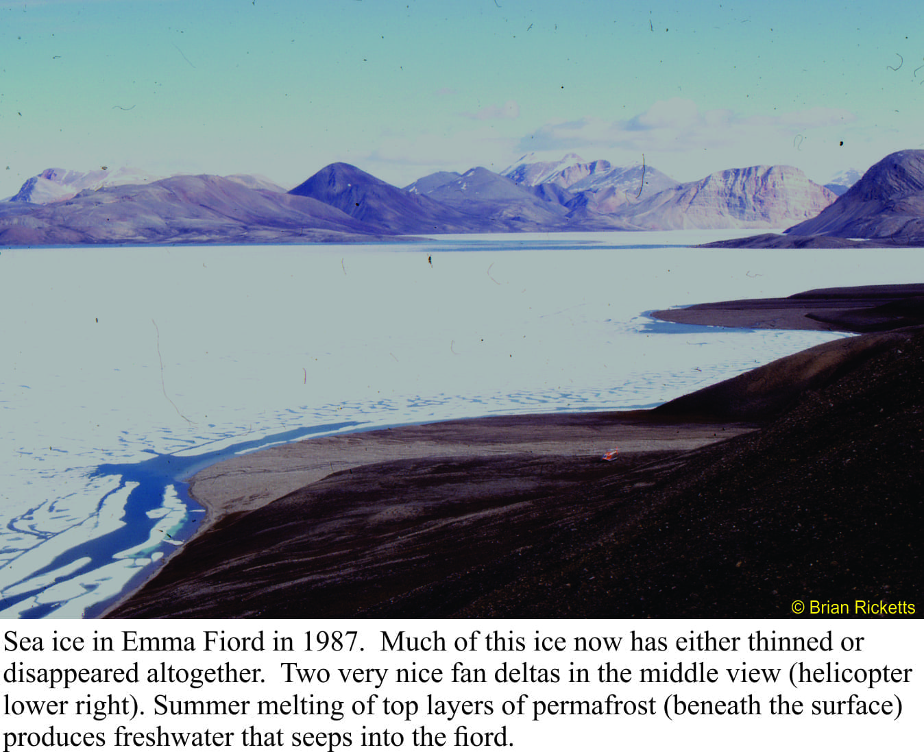
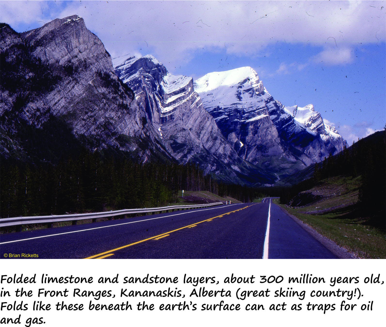
Sea levels have risen and fallen countless times over geological history.  We see this in the way successive strata are arranged and in the kind of ancient environments that each sedimentary layer or group of layers represents.  For example, we may observe that layers deposited in relatively deep water are overlain by layers that indicate successively shallower conditions, then inundated once again by deeper seas.  Geologists consider cycles of sea level change like this to be the ‘norm’.  However, deciphering the causes of sea level change remains problematic; has global sea level risen or fallen (for example because of changing icecap volumes), or has the land surface and sea floor subsided or uplifted?  Or have both processes been active?  When we attempt to answer these questions, we need to remind ourselves of what processes are actually involved in changing actual and relative sea level.  This post summarizes the most common causes.   They are relevant not only for geologists trying to solve stratigraphic puzzles, but for anyone considering the effects and potential risks of changing sea levels as they take place today. Continue reading

Facebooktwitterlinkedininstagram
Facebooktwitterlinkedin

Out of Sight but no longer out of mind; Hidden sources of carbon dioxide and methane

Facebooktwitterlinkedininstagram

Emma Fiord, 1987, with lots of sea ice

With the general emphasis on carbon emissions from fossil fuels and the ensuing discussions on climate change, we tend to forget some of the natural sources of greenhouse gases that continually leak carbon dioxide (CO2) and methane (CH4) into the oceans and atmosphere.  Two such sources are gas hydrates beneath the sea floor and permafrost.  Both sequester carbon, but the sequestration is rather tenuous; both can easily be disturbed by natural and anthropogenic processes.

Continue reading

Facebooktwitterlinkedininstagram
Facebooktwitterlinkedin

Class 5; Geology for Kayakers. Kawarau River, New Zealand

Facebooktwitterlinkedininstagram

The Citroen race, Kawarau, NZ

Kawarau River – Rocks that have gone full circle

Kawarau River; kayaking and rafting mecca, water crystal-clear, torrents and gnarly rock faces.  The river, incised into schist, Otago Schist, is a drawcard for whitewater junkies looking for challenging rapids (classes 2 to 5+).  It has a bit of everything, apart from the whitewater – stunning, rugged hill country, easy access and proximity to Queenstown.  Competitions, especially the Citroën attract local and international competitor.  And for an added bonus, the region is also home to some of the world’s best Pinot Noir. Continue reading

Facebooktwitterlinkedininstagram
Facebooktwitterlinkedin

The Oil Kitchen Rules

Facebooktwitterlinkedininstagram

Folded limestone and sandtone in the Front Ranges, Alberta

Oil is a Part of the Rock

As a kid growing up in NZ, my only contact with ‘O&G’ was watching my Dad filling the family car with (at that time leaded) gasoline, and Jed Clampett watching black gold oozing from his backyard.  Jed and his family had to forgo the possums, grits and cat’s paws for the rarefied atmosphere, with a twist of lemon, of Beverly Hills.  They had made their fortune on Texas Tea like countless others have done since. Continue reading

Facebooktwitterlinkedininstagram
Facebooktwitterlinkedin

Class 5; Geology for Kayakers. Huka Falls

Facebooktwitterlinkedininstagram

Huka Falls, New Zealand

Kayaking huka falls


Huka Falls, tourist attraction and Class V+ drop, is either a kayaker’s nightmare or their delight.  The falls themselves are not technically difficult but with an average 160 cumecs tumbling through a 15m gap, they are a bit daunting.  Huka Falls is the first major cataract on Waikato River, about 8 km downstream of its headwaters (Lake Taupo ).  Flow is controlled by flood gates near Taupo township. Most kayaking is done in flows of 50-150 cumecs,, but anything over 130 cumecs is a bit gnarly.   The tourist viewing platform and bridge are close to the top of the falls. So any kayaker venturing through nearly always has an audience.


Continue reading

Facebooktwitterlinkedininstagram
Facebooktwitterlinkedin