The interior of northern British Columbia is rugged, mountainous country. Roads, that tend to be quite rough were frequently opened to provide access to mines and small settlements. It is an isolated part of the world, beautiful, even majestic, but also unforgiving. East of the Coast Mountains and about 200km south of Yukon, is a huge swath of sedimentary rocks, referred to collectively as Bowser Basin. The rocks are Jurassic to Cretaceous, recording a history of about 70 million years duration. Humungous volumes of sediment were eroded from older rocks to the north, that were uplifted and deformed as tectonic plates, or terranes, collided with the ancient margin of North America. Gravel, sand and mud were carried by braided rivers, supplying coarse sand and gravel to the coast and beyond, and to large deltas that supported lush forests (later converted to coal). Continue reading →
Mud
It supports geological processes.
It flows, subsides, and leads to failure, sometimes catastrophically.
It can be beneficial, forming fertile river floodplains.
It can be a pain in the neck, clogging infrastructure.
It oozes when soft; dries brick-hard
People bathe in it. Pigs love it.
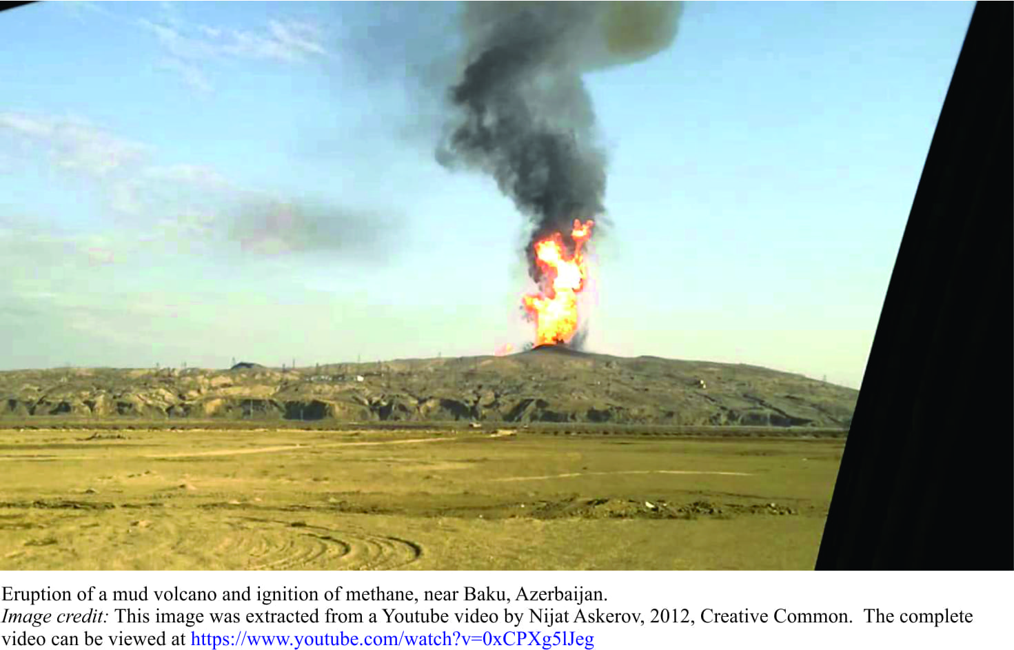
And it erupts, as volcanoes.
Not the magmatic kind, with 1000oC lavas or explosive ash columns, but eruptions nonetheless. Most mud volcanoes are much smaller than their magmatic counterparts; some only a metre high, others 10s of metres. Eruptions may be the quiet, oozy kind where mud flows, slithers and slides down slope, or more violent, shooting sticky stuff 10s of metres into the air (or water); some even ignite in a cascade of fireballs. And yes, they do form on the sea floor. One example in 2015 along the Sea of Azov coast (land-locked between Russia and Ukraine), sent mud and water several metres into the air; you can see the muddy jetsam gradually expanding across the sea surface. Continue reading →
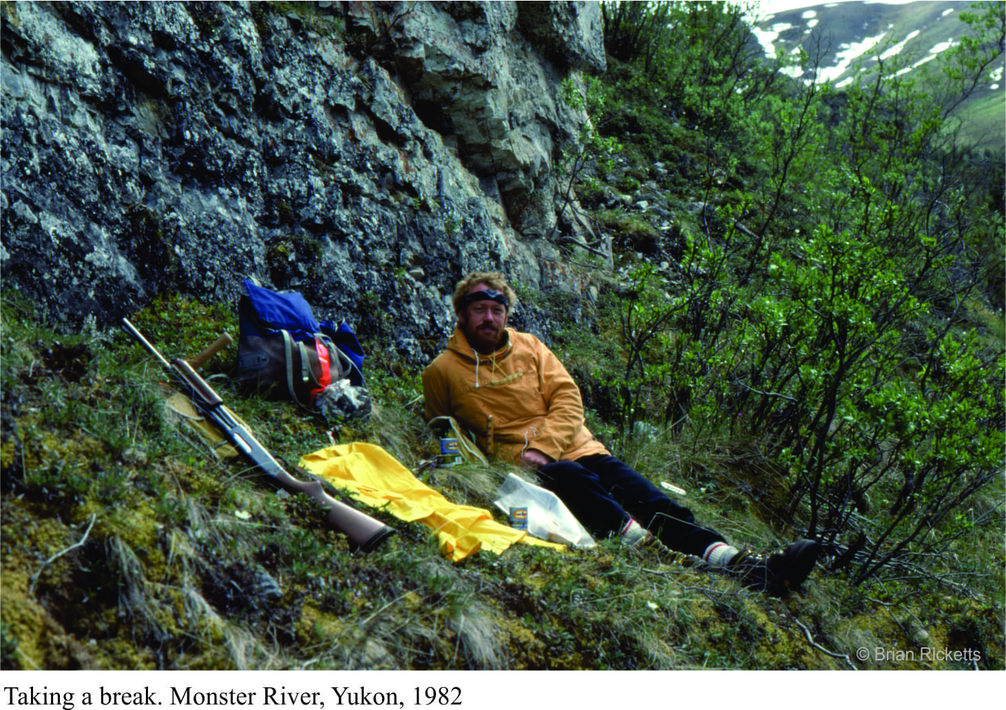
The best field projects are those that last several seasons; the ones you kind of own or share with any number of co-conspirators. These are the projects for which there can be scientifically productive tangents, and where there is usually regional or universal context. Then there are those odd, short-term projects that, at the time, seem a bit ad hoc but still present the opportunity for good science, and new adventures; 1982 was such a season. I was tasked with sorting out a group of sedimentary rocks in west Yukon, a hop, skip and a jump from the Alaskan border. This was the first and last time I worked in an area with substantial bush cover. The best exposure was on ridges above the tree-line, but to get from one ridge to another required crashing through northern boreal forest and the odd, insect-infested swamp. The black flies, deer flies, mosquitos and no-see-ums were something else. Continue reading →
My early geological education was very much New Zealand centered; the gamut of sedimentary, igneous and metamorphic rocks (there are no Precambrian rocks in New Zealand), in the context of a landmass (and attached submerged bits) still rent by active faults and erupting volcanoes. The timing was fortuitous. We were taught at the cusp of the ‘new tectonics’, sea-floor spreading, and the morphing of continental drift into plate tectonics. The fixists were a disappearing breed; now everything was on the move, attached in some way to one tectonic plate or another, rifted, drifted, and eventually subducted. Now, the rock formations, faults (particularly the Alpine Fault), and the volcanoes, were all connected in one, all-encompassing global, plate tectonic system. Geologically active New Zealand had a place in this grand scheme.
Admittedly, not all our professors found it easy to teach these revolutionary ideas. We would be exhorted to go and read the latest journal papers, and come back with questions – I guess this gave the teachers time to read the articles themselves. But it was an exciting time, reading the claims and counterclaims. It really was a (Thomas Kuhn) paradigm shift.
Landing on the shores of Belcher Islands (Hudson Bay) was also something of a mind warp; from a country that straddles a plate boundary, has a volcanic rift zone in central North Island, and faces a subduction zone within a stone’s throw of the east coast, to a part of the Canadian Shield where not much has happened over the last two billion years. Perhaps that’s a bit of an exaggeration, but this prolonged period of stasis had its advantages. The rocks, despite being about 2000 million years old, are loaded with beautifully preserved structures and fossils. They were not cooked by metamorphism during the time they spent being buried, nor fractured beyond recognition by tectonic forces. Basically, everything was intact. Stunning.
For someone interested in deciphering ancient sedimentary environments, being parachuted into the Belchers and being told to take the rocks apart, layer by layer, sequence by sequence, was initially a tad scary; an emotional response that quickly dissipated once the measuring, observation, and interpretations had begun. On finishing the work on one set of exposures, we couldn’t wait to get to the next, and the next.
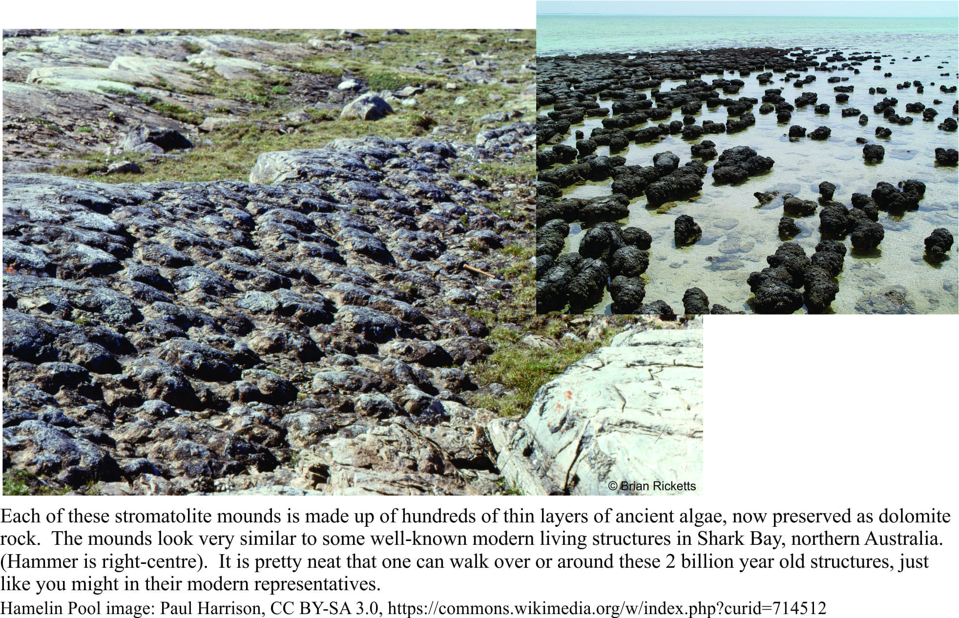
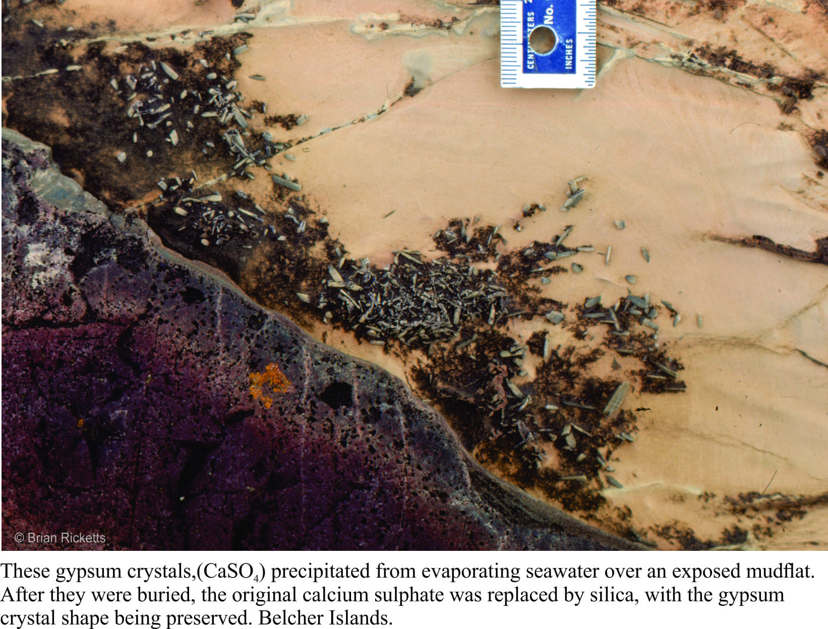
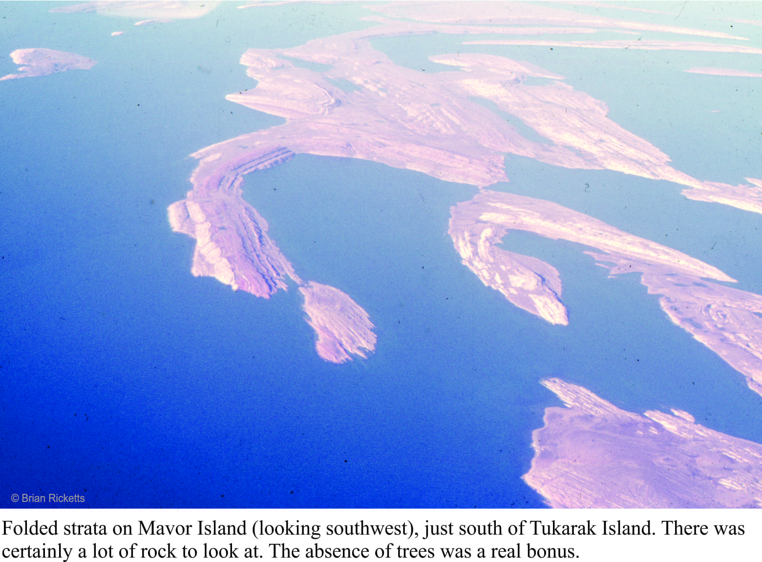
If you were to stand all the Belcher strata in a single pile, it would be almost 9 km thick. But this pile was subsequently tipped on its side. Over the eons, the rocks were eroded by rivers and scraped by ice, fortuitous levellers that provided windows into each layer. Geologists are enticed to enter these portals, at least in their mind’s eye; the rewards are huge. We can envisage times when there were broad platforms of limestone (now all converted to the mineral dolomite), that harboured a massive biomass of primitive algae, stromatolitesof all shapes and sizes; layers as thin as a fingernail, and reefs 10s of metres high. The platforms were covered by warm, seas that shoaled into tidal flats and (deserted) beaches. Some areas infrequently inundated by high tides, became desiccated; there are remnants of minerals like gypsum and halite (common salt) that attest to salty seas. Walking over rocks like these kindles the imagination; a beach stroll, waves rolling in like they have done for billions of years, or parched landscapes exposed to the full effects of sunlight uninhibited by oxygen and the UV dampening effects of ozone (the incidence of UV light must have been intense). The experience is humbling.
However, idylls have a tendency to dissipate in the fog of time or, as was the case here, a smothering by erupting ash columns and lava flows. Now we get to walk across the tops of really ancient lava flows, around piles of pillow lavas, or along catastrophic pyroclastic flows of ash and pumice. The earlier tropical paradise had been obliterated, but even in this volcanic brutality there is wonder.
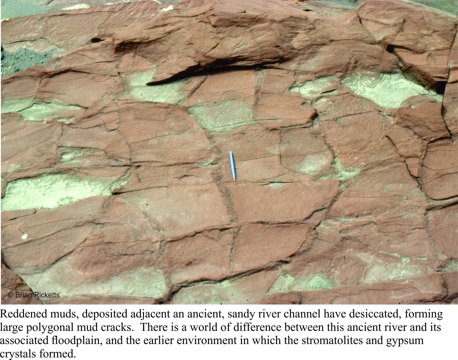
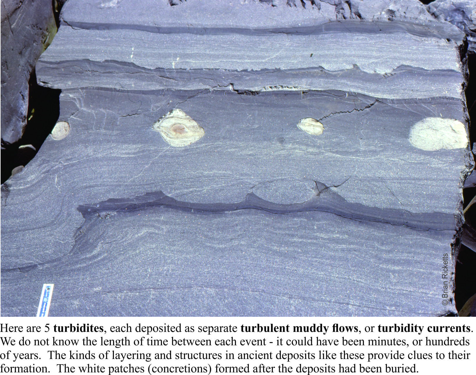
Other strata tell of deep seas fed by turbulent mud flows cascading down an ancient submarine slope, and of sandy rivers turned red by iron oxidized by the gradually increasing levels of oxygen in the ancient atmosphere (deposits like this are commonly referred to as red beds). In every layer, every rock we looked at, there were mysteries waiting to be unravelled. A geologist cannot hope to solve all such questions, but finding a solution to even one of them is incredibly satisfying.
I spent a total of 5 months in the field during the 1976-77 summers. This was not the kind of location where, if I’d forgotten to do something, I could whip back for a couple of days to sort things out. Several of my student colleagues were doing similar kinds of research in remote parts of the country – field seasons were long. Once you had arrived, you were there for the duration. And despite the sense of excitement and discovery, it was always good to get back home.
Have you ever looked at some locale on a map or photograph and thought “that looks like an intriguing place to work”, only to find, sometime later that you are smack in the middle of that same spot? Time-warp? Some god’s lap?
I was preparing to travel to Canada. The plan was to do a PhD, and because I had not long completed a Masters thesis on geologically very young sedimentary deposits, had entertained the idea that research on very old rocks would add a kind of symmetry to my geological outlook – from one end of the geological time-scale to the other. In preparation, I borrowed The Geology of Canada, a weighty tome, and homed in on the Precambrian system (basically everything older than 540 million years). What caught my attention were some squiggly-shaped islands about 150km off the southeast coast of Hudson Bay; the Belcher Islands. Their shape belied some interesting geological structures, and the strata a mix of sedimentary and volcanic rocks about 2 billion years old. What a neat place to work, although I envisioned the islands to be treed.
I arrived in Ottawa (early January, 1976) to minus 25oC and snow; I had never seen so much snow. I thought it quite beautiful, which elicited wry comments from the Ottawans I was meeting who were sick of shovelling driveways and digging vehicles out of snow drifts. Destination – Carleton University. My supervisor was to be Alan Donaldson, well-known in Precambrian geology circles. Following the introductions, he announced that my project, unless I had some objection, was to focus on the Belcher Islands. LOL. I was to spend 5 months there in total over the summers of 1976-77. The social environment, the weather, and the geology were remarkable.
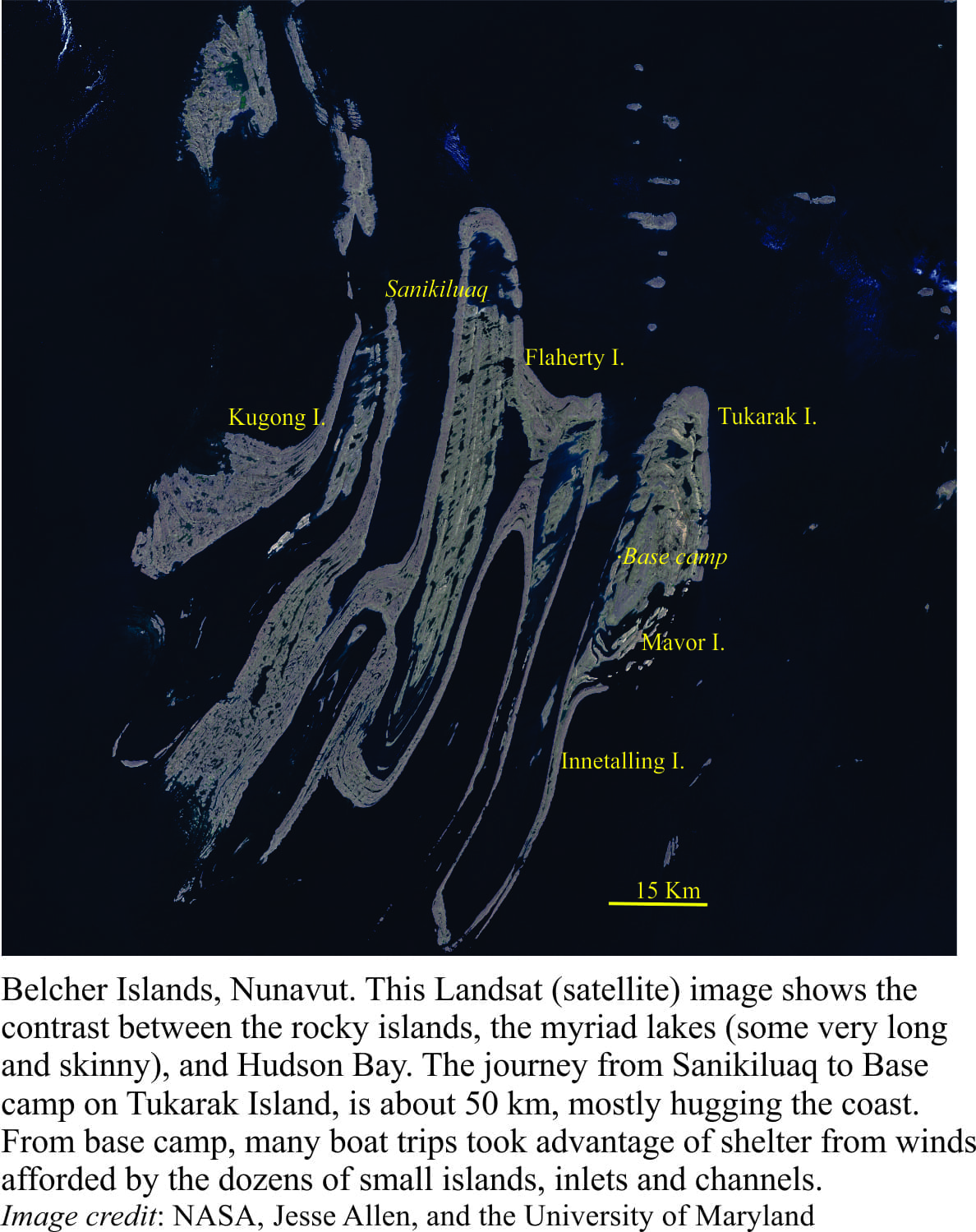
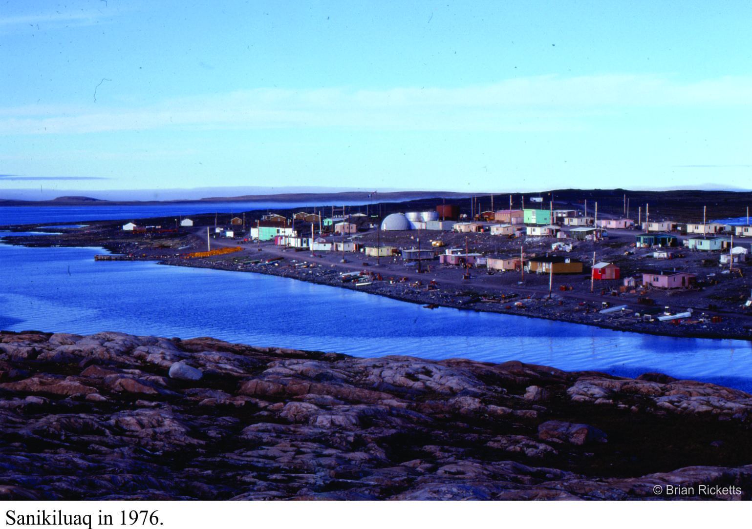
Getting to the islands was a milk run: a drive to Montreal airport, a flight to Moosonee near the southern shores of James Bay (northern Ontario), a very noisy DC3 leg to Umiujaq (Quebec) where we picked up field equipment (kindly loaned to us by the Geological Survey of Canada), then Twin Otter across the 150 km to Sanikiluaq, the sole village on Belcher Islands. We were able to stay in a small house owned by the Hudson’s Bay Company for the two days needed to sort gear, buy food, and make sure the two inflatable Zodiacs and outboards worked. My assistants (John McEwan in 1976, Mike Ware in 1877) and I always used two boats as a safety measure (and for visitors).
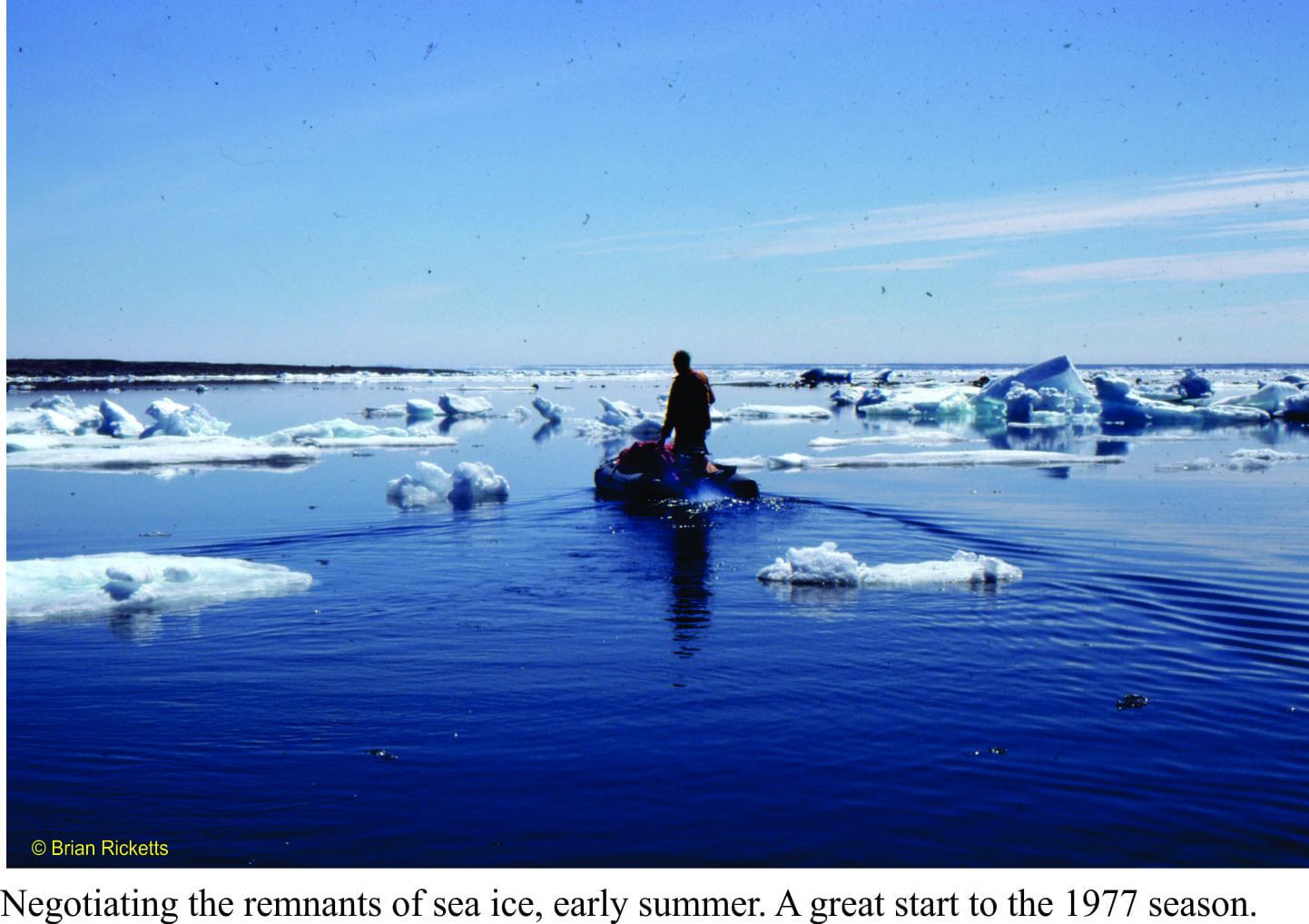
The seas around the islands are mostly ice-free during the summer months, but the water is still only a few degrees above freezing, and the air close to the water cold. Even in the summer, we had to bundle up with wet-gear, fleeces, and life jackets (I was told the life jackets were necessary for insurance purposes – so they could retrieve the bodies). The islands and intervening channels are also elongated north, so that wave set-up could change drastically any time there was a wind shift. We were caught out a few times with unfavourable seas, but there was always somewhere to shelter.
Belcher Islands are mostly held together by a thick volcanic unit that creates more or less linear coastlines. The strata were folded, like a series of waves, into simple anticlines and synclines, such that the package of sedimentary rocks is exposed in the anticlines, while the synclines are drowned by major channels and inlets. The terrain is subdued with low relief – the islands were scraped clean by the Laurentide Ice Sheet during the Last Glaciation.
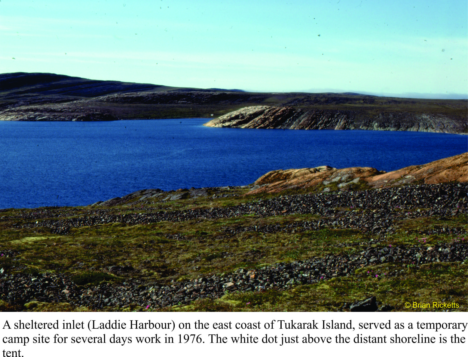
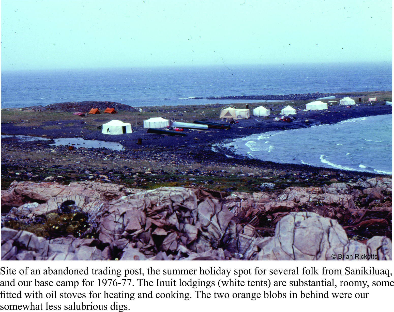
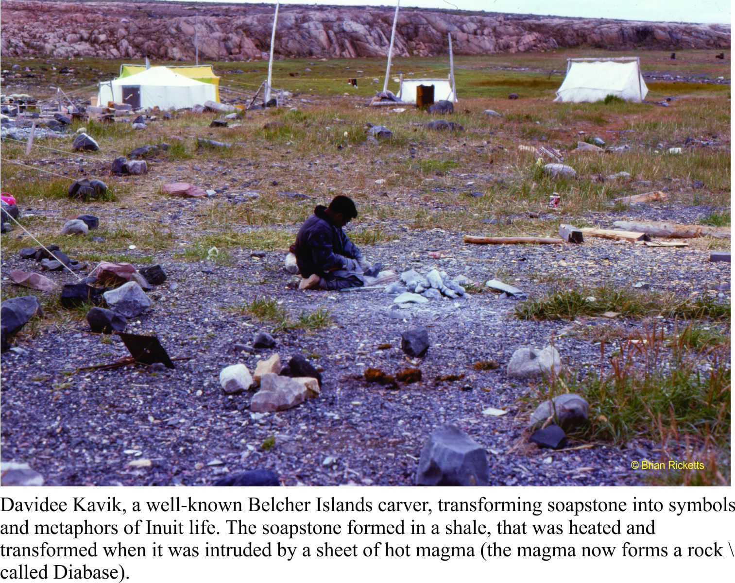
Our base camp was to be in a small, relatively sheltered inlet along the western shore of Tukurak Island (one of the largest and easternmost island). It was a 3-4 hour journey, depending on weather. This is the site of an abandoned Hudson’s Bay post. It was also the favoured summer holiday spot for local Inuit, primarily because it is close to their source of soapstone. Belcher Island soapstone has an enviable reputation amongst northern communities, because of its uniform, deep green colour, and general lack of fractures that would render carving difficult. Whenever we were in base camp, we would watch the elders carving, and teaching their younger folk the same skills. They would also bring us bannock and Arctic Char. And there was never a shortage of Inuit kids around, checking in, telling stories, or simply hanging out. We would spend 4-5 days away from base camp, returning to stock up and cache samples. Time in base camp was always a delight.
Belcher Islands sit well below the Arctic Circle at 56oN (latitude), and yet the landscape is typically Arctic. The northern Canada tree-line is located south of Hudson Bay, such that the Islands have a typical Arctic flora (especially wild flowers), and no trees – so much for my earlier, wistful image of the place.
The weather alternated between gorgeous, with light winds and clear skies, and abysmal. On more than one occasion we returned to camp from a day’s work to find tents down and sleeping bags soaked. High winds also prevented longer excursions with the boats, unless we were riding through sheltered channels and inlets. With the boats, there was always one eye kept on the weather.
During the first couple of weeks in 1976, Bill Morris (Geological Survey of Canada) had joined us to sample rocks for geophysical measurements (looking for ancient magnetic poles). The day he was to leave base camp (and fly out of Sanikiluaq) was particularly inclement. He insisted on attempting the trip, but instead of using our inflatable boats, I decided to rent one of the larger, sturdier, Inuit canoes with twin outboard motors (I was the only one with boating experience). We ventured out of the sheltered inlet, into the maelstrom – at least that’s what it looked like from the perspective of our small craft. I doubt we got any further than 50m from the inlet entrance; a lull in the waves, a quick decision to about-face, a beeline back to calmer waters, and the colour returned to the faces of my two passengers.
“Guess I’m going to miss my flight”. We all new he probably would have missed it, even if we had continued. Back to base camp to drain what was left of a bottle of scotch, and cogitate on an earlier field season on a warm New Zealand Pacific coast.
This is the first blog on my Belcher Islands episode
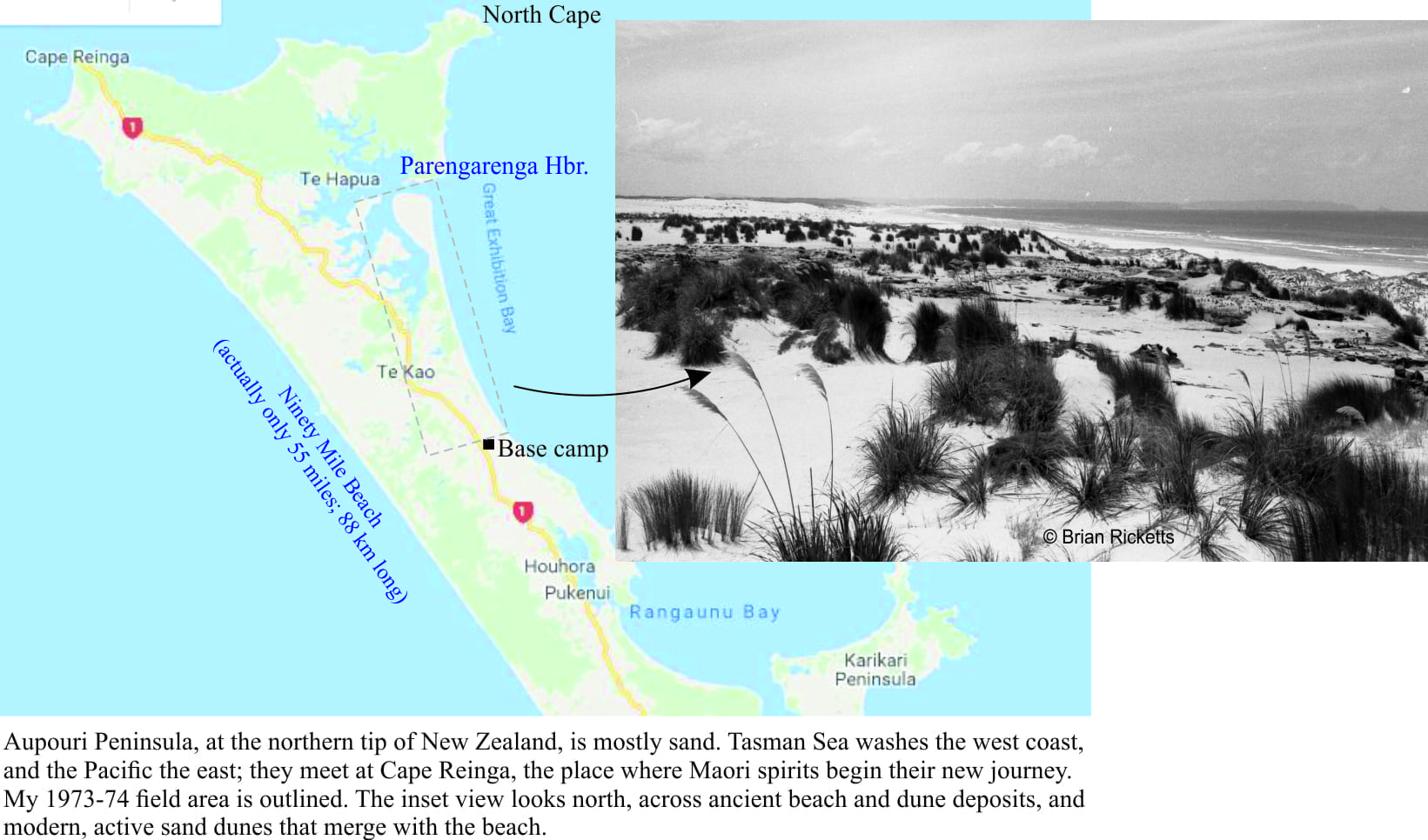
Final exams over, a moment of tomfoolery, and I found myself disconsolate in a hospital bed, recovering from an operation on a dislocated knee (no such thing as key-hole surgery back then). I had completed my BSc (November,1972) and was contemplating doing a Masters on something sedimentological. A visit from one of my professors, a period of impatient recovery, then loaded the aging Morris Minor and headed north almost as far as it is possible to drive in New Zealand. This was to be my first bona fide field project.
My field area incorporated a 22km stretch of glorious coastline that, at its northern extent, culminated in a sandspit (Kokota Spit) and Parengarenga Harbour. The task was to decipher the sand deposits, from the very recent to maybe a million or so years old. This narrow strip of land is part of the much larger Aupouri Peninsula, founded on sandy bars and spits that connect small islands and headlands of harder, older igneous and sedimentary rock. Tasman Sea washes the west flank of Aupouri, and the Pacific the east; the two seas meet at Cape Reinga, the place where Maori spirits begin their new journey. Continue reading →
A rocky mound, 1500m above, and 119.44 km straight-line distance from the sea, is about as far as one can get in New Zealand from either the Tasman and Pacific coasts. The location is in central Otago, southern New Zealand, a region better known for its Pinot Noir. No one lives at this farthest point from the beach. In fact, most New Zealand folk live only a few kilometres from the sea. Hence the summer exodus. Any nostalgia for those snow-bound, icicled, northern hemisphere winter solstice festivities is short-lived, banished by squealing kids and crying gulls.
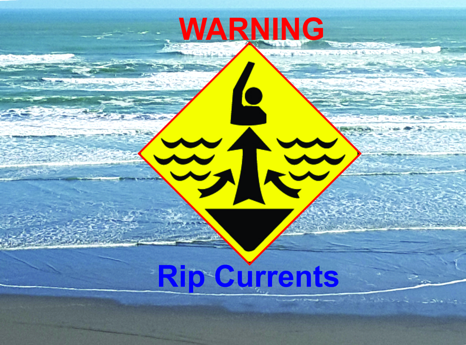
I don’t like putting a damper on this general sense of merriment but, despite all the signs that warn, all the cautions and reminders of potential dangers, people drown. New Zealand has one of the worst records for preventable drownings of any OECD country (113 in 2015). Most drownings occur at seaside beaches where rip currents are the leading cause of strife for swimmers – there were over 1300 rescues in 2015 (NZ), and most of those were plucked from rip currents. These statistics are repeated the world over.
As waves approach the shore they begin to interact with the sea floor, growing in amplitude (wave height) until they break. Waves in the surf zone move the water mass onto the beach. Gravity requires that all this water then moves down the beach slope, back to the surf zone. On all beaches, the return flow, or backwash, produces an undertow that flows beneath the incoming waves. Undertow occurs everywhere along a beach. Its influence is generally confined to the surf zone, and for the most part is not dangerous (although it can be quite a strong flow). Undertow IS NOT the same process as a rip current. Rip currents are not that same as tidal currents.
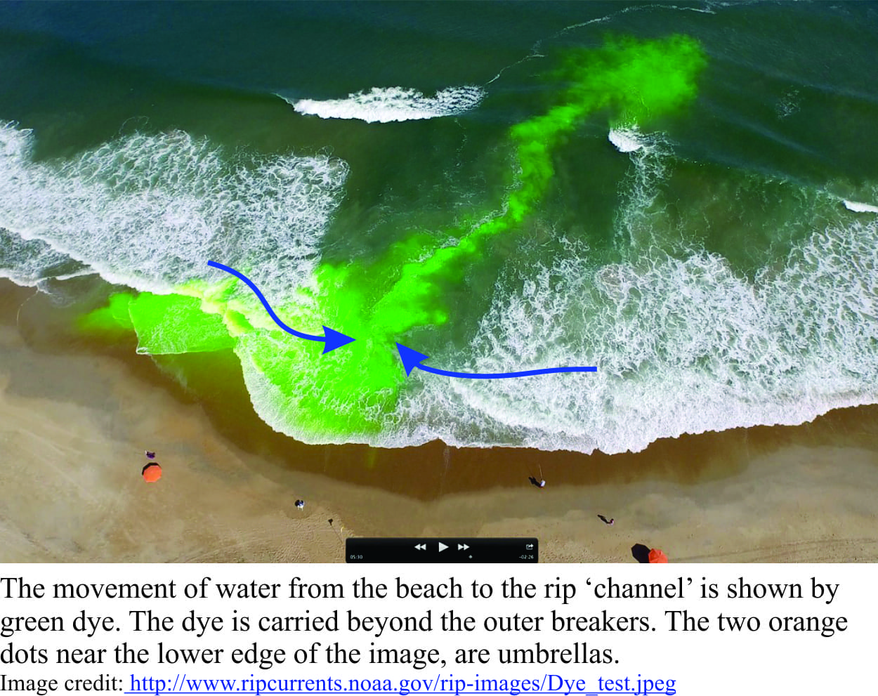
As water moves back into the surf zone, it commonly shifts sideways across the beach, a process referred to as along-shore drift. Most swimmers will have experienced this ‘drift’ when they find themselves farther along the beach from where they started (this is usually where the local surf lifeguard starts waving at you to return to the flagged swimming area). Rip currents form when the returning seawater is diverted and focused by shallow holes and sand bars on the sea floor. If the sand bars extend onto the beach, then the waterline will have a kind of point-like shape along the beach (as shown in the images here). These channel-like currents frequently extend beyond the surf zone. Rip currents are narrow flows (a few 10s of metres wide) that move rapidly offshore; current speeds of 4m/second have been recorded, speeds that are well beyond the ability of even the strongest swimmer. The currents are powerful because so much water is being focused through a relatively narrow gap. Rips can appear suddenly on any beach where there is appreciable wave activity. They can also form adjacent to rocky promontories.
Rip currents are best viewed from an elevated vantage; they are not easily seen from the water’s edge. Useful identifying features include:
The surface waters of a rip tend to be relatively calm or rippled,
The current cuts through the surf and is usually clear of large breaking waves,
Currents commonly carry flotsam (including swimmers) or sediment offshore, and hence may appear cloudy, and
A point-like, or cuspate shape to the waterline along the beach may indicated submerged sand bars – such features increase the likelihood that rip currents will form.
While swimmers and life guards tend to view rip currents with (respectful) dislike, people who study coastal processes see them as one process among many, that shape coastlines. On sandy coasts, sediment is constantly being transferred among the deeper offshore regions of the sea bed, the shore and beach, and sand dunes. Sometimes the beach or dunes are in sand deficit, and at other times in surplus. Breaking waves tend to move sand onshore, whereas undertow and rip currents tend to move sand seaward. There is generally a balance between the onshore and offshore transfer of sand, but this can be disrupted by seasonal changes in tidal currents and storm tracks, by decadal cycles in the movement of ocean water masses, and by longer-term rises or falls in sea-level. Rip currents, despite the risks they pose, are an important part of coastal sand budgeting and transfer . They are a geological phenomenon.
The advice normally given to anyone caught in a rip is DON’T PANIC (perhaps more easily said than done), and don’t try to swim against the current – you will not win that contest. Swim parallel to the beach and you will eventually exit the current. Surf life-saving folk put up flags where they assess the safest stretch of beach to be. It is common for these flags to be moved up or down the beach, as rips come and go. But these common-sense warnings are ignored by too many – if they’re lucky they won’t enter the books as another statistic.