
 Deceptive news is the art of pulling wool over the eyes of the populace, a tool (recently resurrected by certain politicians) for persuasion or dissuasion. Orson Welles got more than he bargained for when, on October 30, 1938, he orchestrated a radio adaptation of H.G. Wells The War of The Worlds, a 1898 sci-fi that pits intelligent Martians against Victorian Britain. Welles broadcast created a mix of amusement in some commentators, and in others panic and anger; panic in the unwitting, anger in the duped (especially other broadcasters), and amusement in all the above.
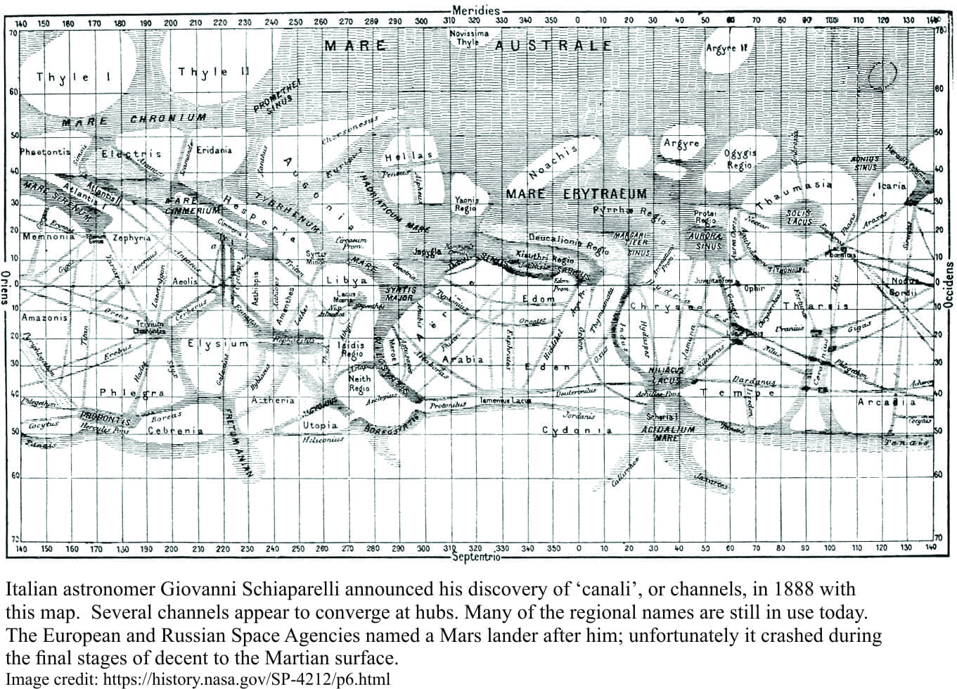
Well’s novel, apart from being the product of an agile mind, was influenced by some of the popular astronomical ideas of his time. Italian astronomer Giovanni Schiaparelli produced, in 1888 a wonderfully detailed map of Mars showing (above image), among features such as seas, islands, and other landmasses, a network of ‘canali’, or channels. Canali was misinterpreted in English as canals, and along with all its connotations of intelligent life, the idea of Martian canals entered popular belief.
Were the anthropomorphic connotations of the word canali deliberate? Percival Lowell, a self-made American astronomer certainly thought so. In 1894 Lowell announced his own findings, that there were indeed canals, 100s of them, many of them straight, intricately networked, and all artificial, which of course meant intelligent beings. H.G. Wells simply expanded Lowell’s ideas to the point of delightful absurdity. That O. Welles would later foist his version of events on an unsuspecting public seems quite reasonable.
Since the 1970s we have been projecting our own intelligence and sense of puzzlement on Mars, using satellites and landed vehicles. There are no artificial canals, but there are canyons, channels and gullies, landforms that bear an uncanny resemblance to terrestrial analogues. There is now a significant body of evidence to indicate that Mars was once watery.
On earth, sediment is distributed far and wide by flowing water. Very fine sediment from rivers or wind-blown dust is commonly suspended in water; the sediment gradually settles on the sea or lake floor. Coarser sediment, like sand and gravel tends to be ‘entrained’ close to the sea floor or river bed by fast flowing water. Sediment that is moved in this way forms a variety of structures such as ripples and larger dune-like structures.
Rivers in particular, generally move sediment to larger repositories, or basins such as seas or lakes; The kinds of landforms that represent these processes are very distinctive. On Mars, there are several landform-indicators of flowing liquid (most likely water), most of which have direct terrestrial counterparts; deltas, straight and meandering river, point bars, alluvial fans, and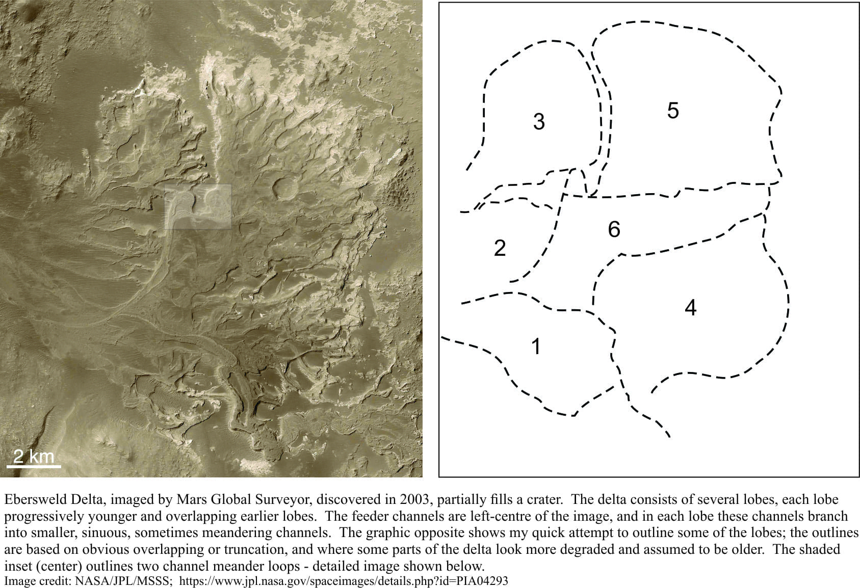 gullied crater margins. One such Martian landform, imaged by NASA’s Mars Global Surveyor, is the Eberswalde Delta which contains many of the ingredients that also make up terrestrial deltas. In this case, sediment making up the delta was probably derived from outside the Eberswalde Crater and subsequently transported by rivers into the crater:
- The delta consists of one or two main river channels (left side) that split into many smaller channels,
- Bifurcating channels form distinct lobes – there are at least 6 of these, where each lobe represents a specific period of delta formation.
- Switching of delta lobes is common in terrestrial delta. Each lobe represents a period of sediment movement and deposition, in this case into the deep crater basin. At a certain point in time, the channel will switch direction and begin to build a new lobe.
- Each new lobe partly overlaps older lobes, such that the younger deposits appear to lie on top of older deposits.
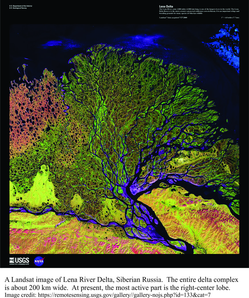
- The Lena Delta in Russia provides a nice analogue for the overall shape of channels, with some active parts of the delta (especially the centre-right) juxtaposed with less active segments.
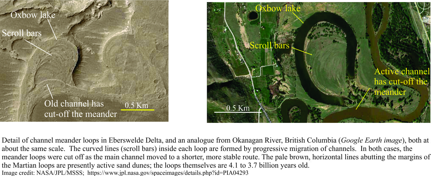 The Eberswalde Delta has another remarkable set of structures. Meander loops (opposite image), seemingly identical to those seen in meandering rivers on Earth, contain patterns of progressive channel movement. The Martian meander channel loop was eventually cut off, perhaps forming an oxbow lake like its terrestrial counterpart.
Martian landforms like these are mostly found in regions assigned to the Noachian Period, a geological interval that extended from 4.1 to 3.7 billion years. All the evidence (so far) points to a time when surface water was common as rivers, lakes, and possibly seas; groundwater can be added to this mix. If this was the case, there must also have been water vapour in the atmosphere. The surface must have been significantly warmer than the present frigid temperatures; water vapour probably provided some degree of greenhouse protection. Overland flow of water also produced sediment, much of which ended up in impact craters and broad lowlands.
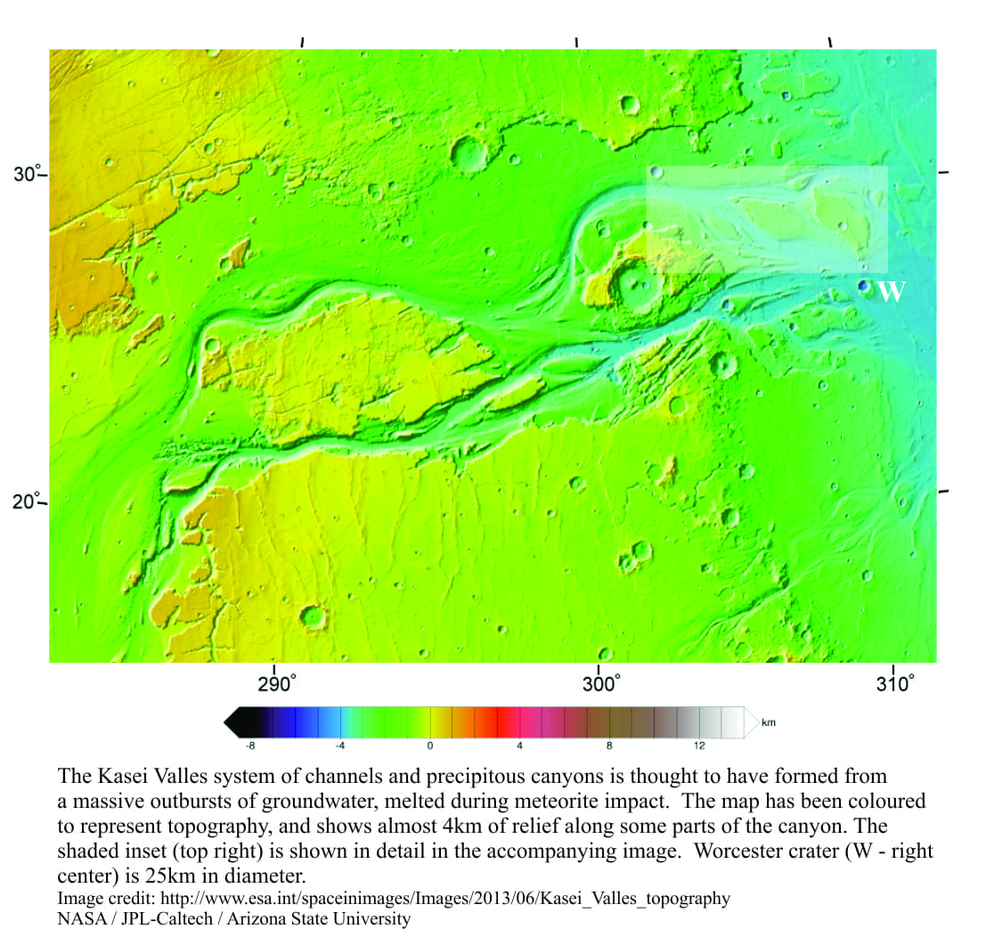
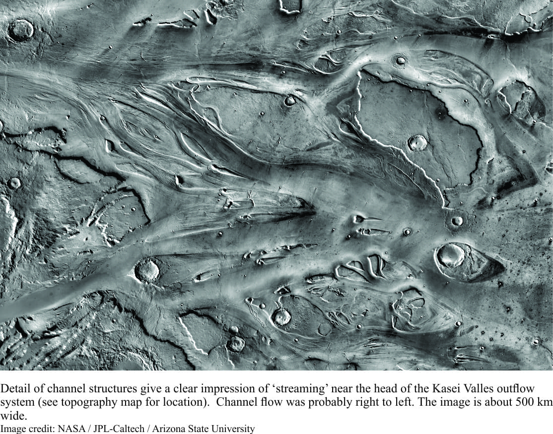
However, some extremely large outflow channels, such as the Kasei Valles formed sporadically during a later, generally drier and colder time known as the Hesperian Period (3.7 to 2.9 billion years). This massive system of channels and canyons extends about 3000km from its source in the Tharsis volcanic region, and through about 4km of topographic relief. The overall form of the channels, plus more detailed images of flow-like structures within the channels, indicates possible catastrophic outbursts of humongous volumes of water. One popular hypothesis to account for this involves massive volumes of frozen groundwater being released either during meteorite impact or volcanic activity and heating.
The comparison between Eberswalde Delta and Kasei Valles mega-floods is quite stark; the delta represents relatively continuous river flow over a long period of time, into a crater. The Kasei Valles outflow formed almost instantly, driven by the forces of impact and directed away from the crater.
Scientific understanding of Martian geology will continue to evolve; some hypotheses will stand the test of experimental and observational rigour; others will become history. Modern science has developed the technology to actually do the field work, albeit remotely. Perhaps we shouldn’t be too hasty to consign Schiaparelli’s and Lowell’s ideas to the theatrically amusing; their observations and explanations were not without context. Keep in mind the possibility that another H.G. Wells may point a satirical finger at 21st century science.
NASA, ESA and other organizations have multiple sites to access imagery and general information on all space missions. SEPM (Society for Sedimentary Research) also has a Special Publication (number 102; 2012) with 12 papers that describe aspects of sediments and sedimentary rocks on Mars. The Introductory chapter by John Grotzinger and Ralph Milliken provides an excellent technical summary of the Martian sedimentary realm.
Pingback: Free Piano
Pingback: Misconceptions and Facts: Lies and Truth About the Business of Modeling