
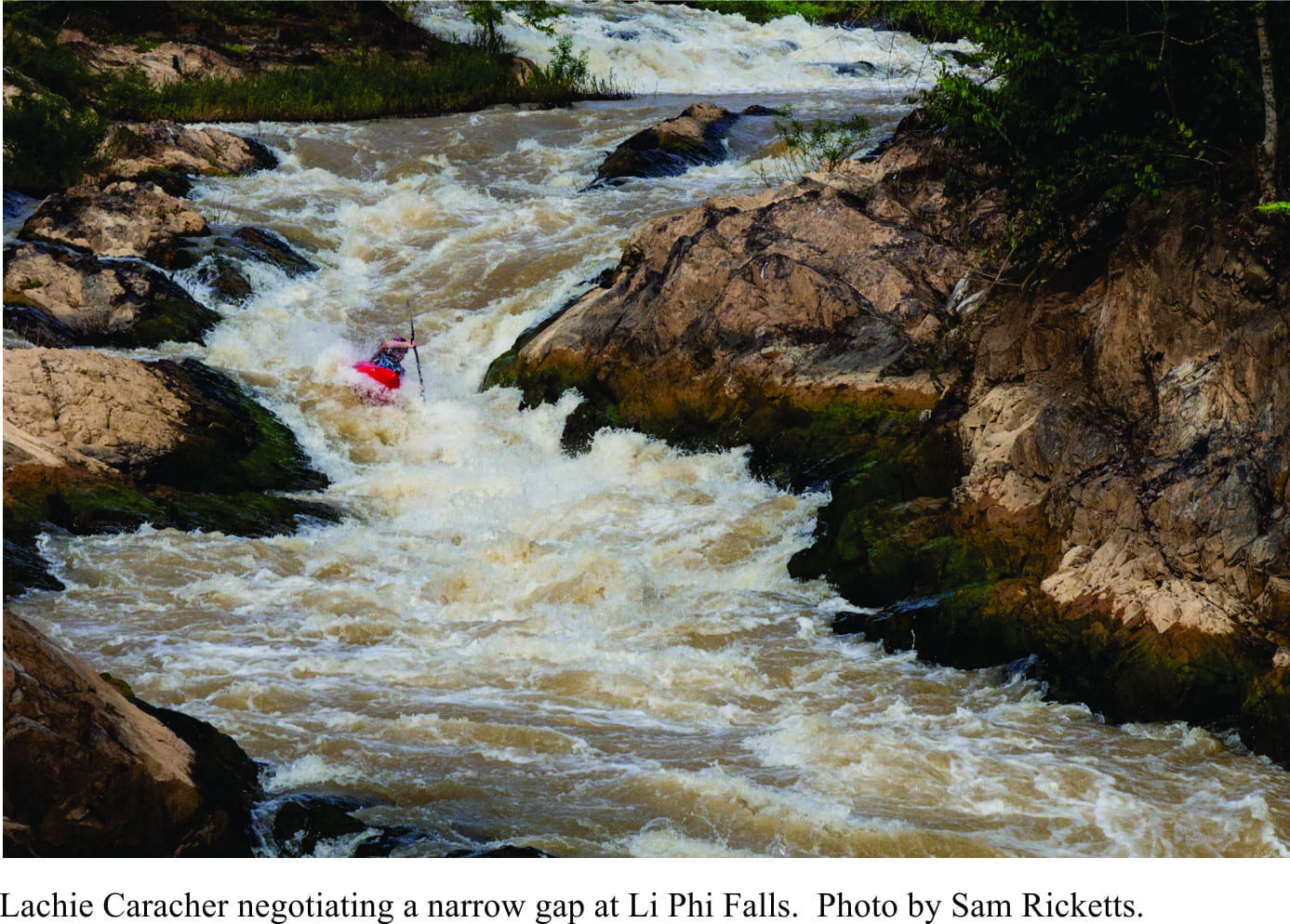
 I am of a generation that, at mention of Laos, Vietnam and Cambodia, I recall images of intense conflict, thankfully long past. The images now are of jungle, peaceful villages nestled among ancient civilizations, and rivers; kayaks instead of gunboats. The coincidence between geology and river in Southern Laos (LDR) has created an area known as 4000 Islands. Here, Mekong River changes from a single channel to multiple braids that thunder across a spectacular array of waterfalls and rapids; a white-water kayaker’s idea of fun. Sam Ricketts, his friend Lachie Carracher and a film crew (Luke McKinney and Lissa Hufford), converged, in December 2016,pon Don Det, an island-town in the middle of 4000 Islands; their focus – Li Phi Falls.
 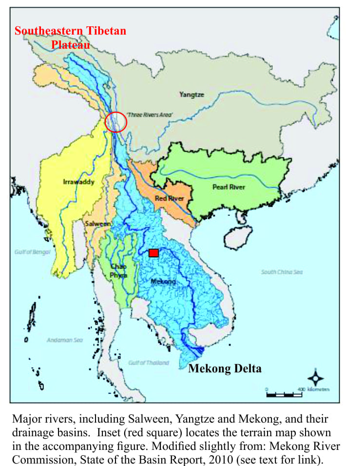 Mekong is a great river. And like other great rivers (Nile, Amazon, Mississippi) they are ancient, their courses and drainage patterns determined by tectonic events that stretch back millions of years. Earth is ever restless, hence all great rivers are still evolving, broadening their floodplains, gouging deeper gorges, or simply changing course.
Here is the source of the map above.
The history of Mekong River also encapsulates deep time. It, like the Yangtze, Salween, Ganges and Brahmaputra, owes its existence to the brutal arrival of the Indian subcontinent along the margins of Eurasia. Two hundred million years ago the continental crust that is now India was part of Pangea supercontinent; it was also several thousand kilometres south of its present position and separated from Asia by the Tethys Ocean. The breakup of Pangea about this time resulted in two major continental blocks; Gondwana (Africa, South America, Australia, Antarctica, and Zelandia,), and Laurasia (N America, Europe and Asia). India, ostensibly a part of Gondwana had begun its divorce proceedings, moving north on the proto-Indian Ocean sea-floor spreading conveyor. Fast-forward to about 50 million years and the Indian plate had reached the outskirts of Eurasia.
Collision between two tectonic plates is a slow-motion process. It usually results in large slivers of oceanic and continental crust and sediment being sliced and stacked into mountains, along with a great deal of crunching and folding. The aftermath produced the Himalayas and Tibetan Plateau. Two animation videos will help you visualise these processes as they apply to the India-Eurasia collision; the Geological Society animation shows a cross-section view of the tectonic plates, and the Chris Scotese animation visualises the plate journey.
A consequence of the rising Himalayan Mountain chain was a new and evolving climate. Changing patterns of precipitation, such as the Monsoons, meant that new drainage also developed. Three rivers began to drain the eastern watershed of Tibetan Plateau; the Yangtze, Salween and Mekong. Today, 40-50 million years later the ‘three sisters’ plunge from the eastern rim of the Plateau (average elevation 4500m), through a narrow region known as the Three Rivers in China’s Yunnan Province; it has been designated a UNESCO World Heritage site (not to be confused with the Three Gorges dam project farther downstream Yangtze River). From there the three diverge; the Yangtze towards Shanghai, the Salween to Myanmar and the Andaman Sea, and Mekong through Laos, Thailand, and Cambodia, eventually ending at its delta in Vietnam – a journey of 4600km. The Mekong on its journey meanders through highlands, plateaux, ravines and floodplains. However, in the 4000 Islands reach it metamorphoses into braid-like channels and a myriad islands; some of the islands disappear completely during the rainy season.
And the white-water…?
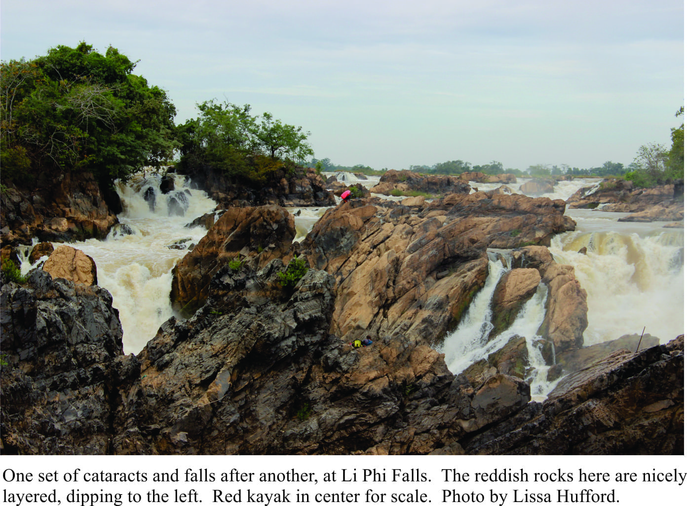
Li Phi is the name given to the entire stretch of falls and rapids across about 20km of 4000 Islands. It means ‘spirit trap’, where the raging torrents trap bad spirits that wash down stream. The falls themselves proved to be a nuisance to early French colonizers because they prevented easy navigable access into the north Mekong basin.
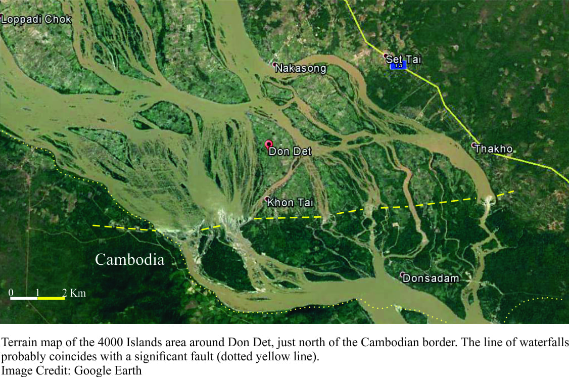
There are some spectacular layered rocks through which Li Phi Falls and cataracts surge. However, specific information on the rocks themselves is sadly lacking, or if it does exist it has not made its way into any of the internet search engines I tried. The rocks are sedimentary. The available maps (very few of these) indicate that the sediments probably range in age from the Cretaceous to the late part of the Jurassic (about 160-65 million years), which leaves a lot of open territory. Most of the rocks around 4000 Islands are distinctly layered and reddish, and probably formed in ancient rivers, floodplains, deltas and lagoons. There is a fault, extending east to west and coinciding approximately with the northern Cambodian border. The Google Earth image above shows a line of waterfalls close to this structure, where the south side of the fault has dropped down.
The total vertical drop across the Li Phi cascades is about 15-20m, but no single drop is more than a few metres. There is no shortage of grade 3 to 5 water. Li Phi Falls traverse the river for many kilometres such that a kayaker never needs to repeat a line twice. The short video by Luke McKinnie shows Sam and Lachie running several great lines.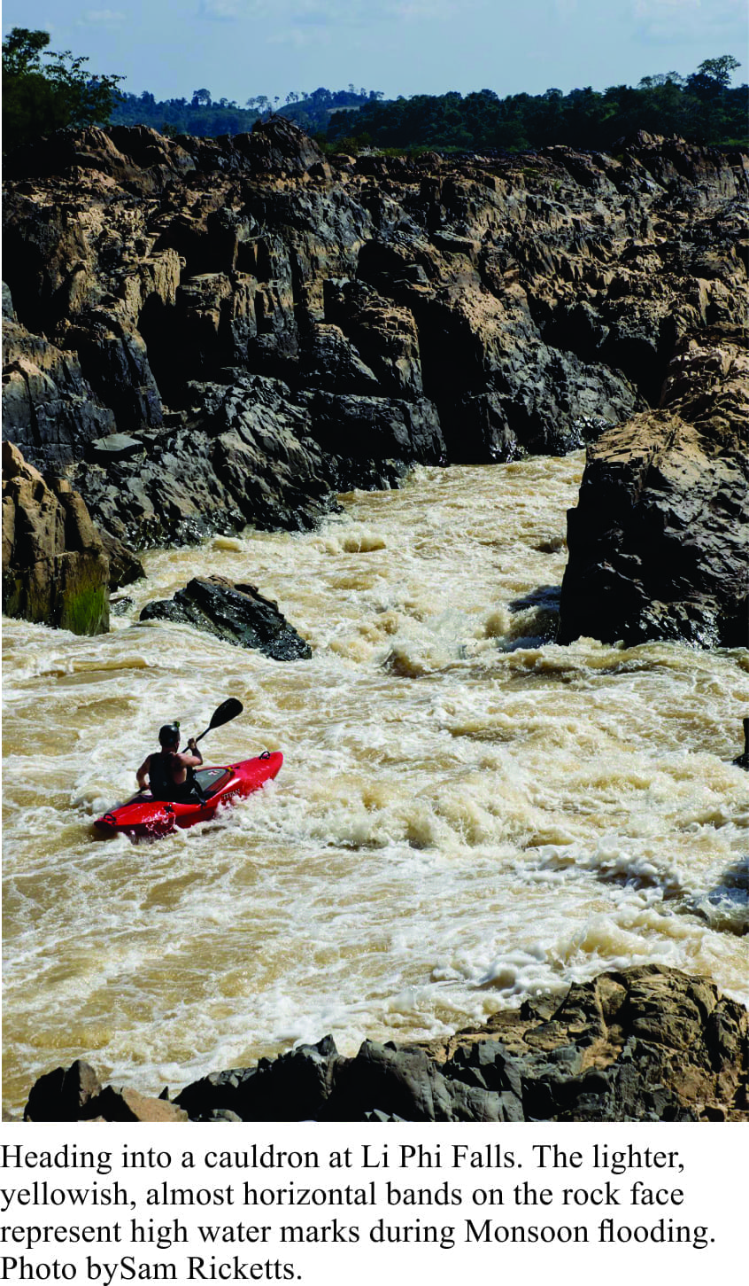 Water levels in the river were still reasonably high in December. During the Monsoon rains Li Phi Falls would be almost impassable. High-water lines are clearly visible in most of the images herein; the lines are marked by light brown bands on rock faces. At times of high flood, it looks as though most of the rocks are covered!
Check out some other Geology for Kayaker posts here: Kaituna, Huka Falls, Kawarau, Pucon, Chile, and Columbia.
Pingback: homepage
Pingback: my blog