
Huka Falls, New Zealand
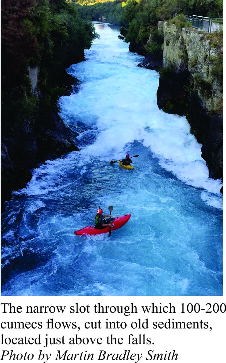
Huka Falls, tourist attraction and Class V+ drop, is either a kayaker’s nightmare or their delight. The falls themselves are not technically difficult but with an average 160 cumecs tumbling through a 15m gap, they are a bit daunting. Huka Falls is the first major cataract on Waikato River, about 8 km downstream of its headwaters (Lake Taupo ). Flow is controlled by flood gates near Taupo township. Most kayaking is done in flows of 50-150 cumecs,, but anything over 130 cumecs is a bit gnarly. The tourist viewing platform and bridge are close to the top of the falls. So any kayaker venturing through nearly always has an audience.
Ordinary geology
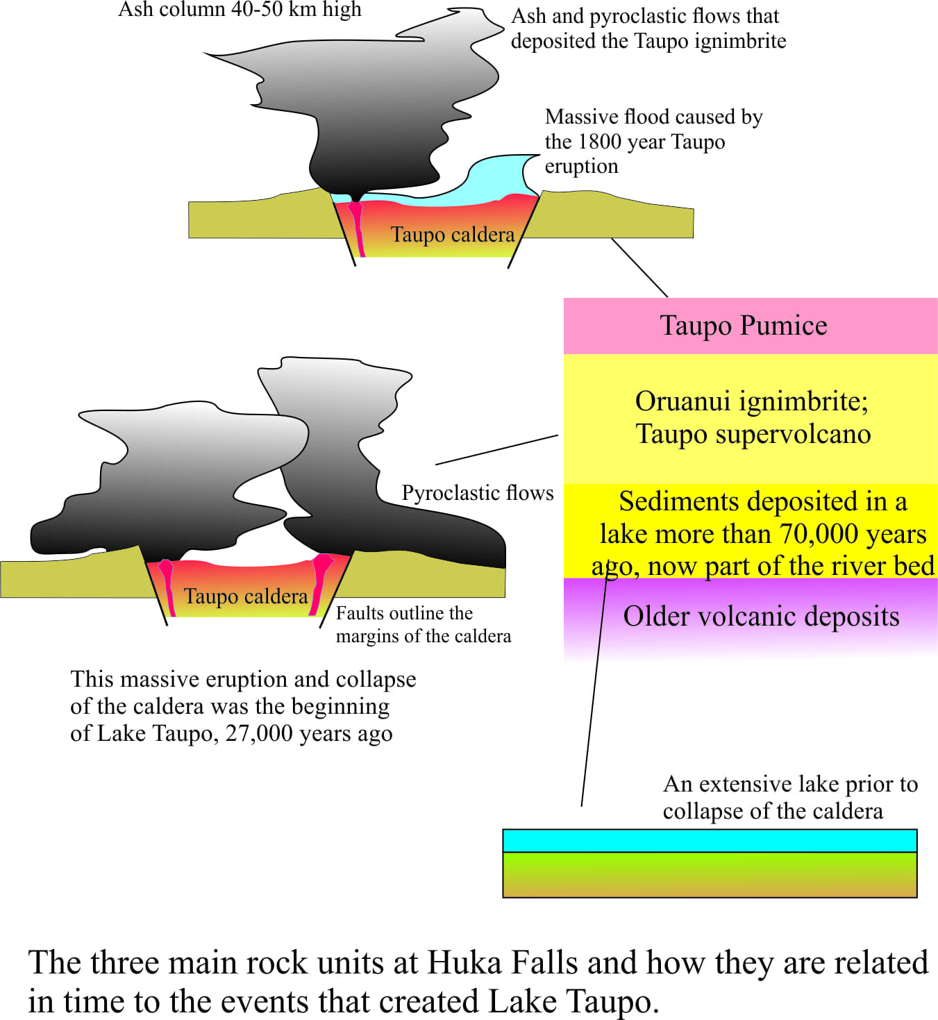
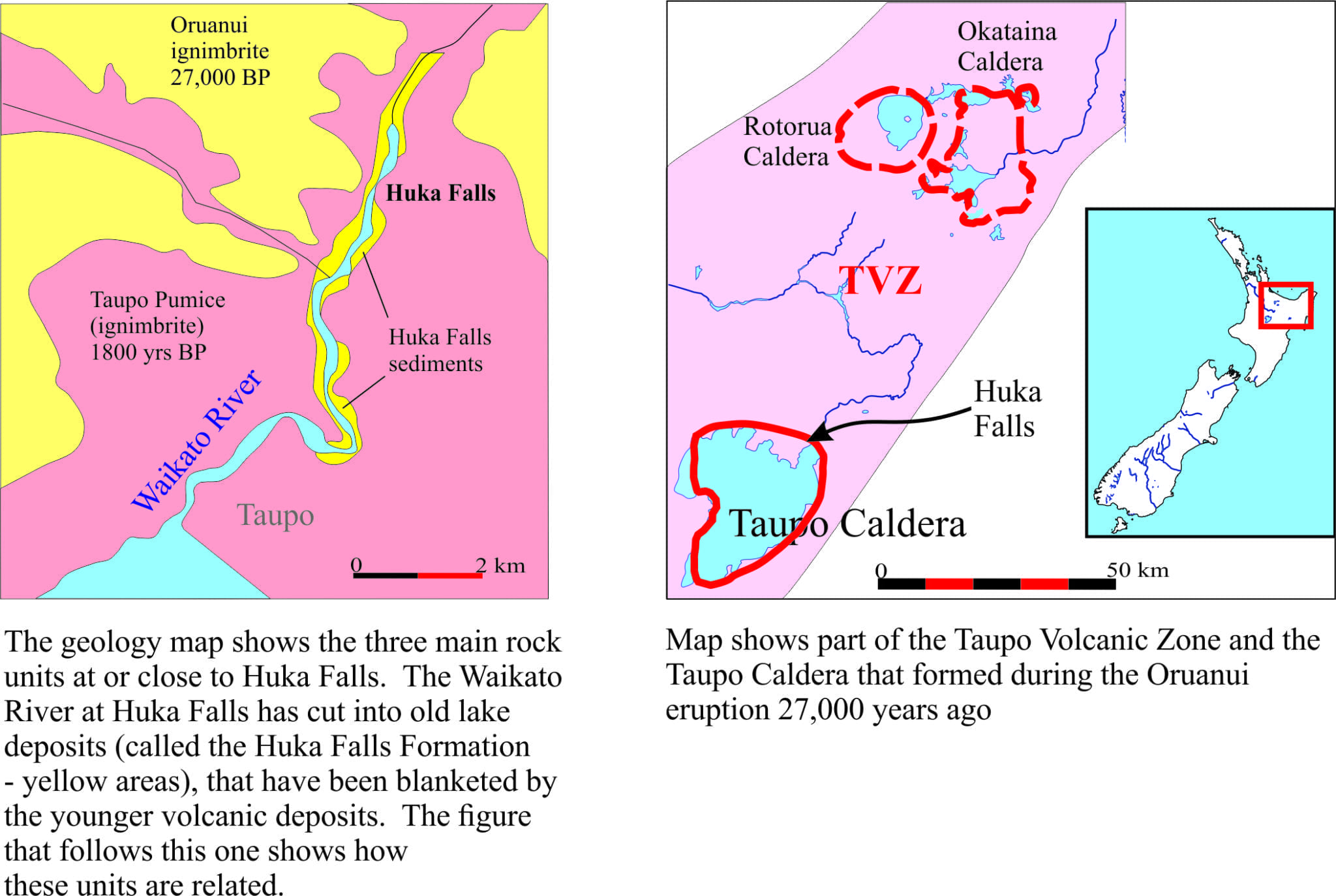 Waikato River, for 3-4 km upstream and downstream of the falls, has cut into and flows over old lake deposits (known as the Huka Falls Formation). The ancient lake extended beyond the present limits of Lake Taupo from about 70,000 to 200,000 years ago. In places the deposits have been hardened by silica that precipitated from hot geothermal fluids that at one time flowed through some of the more porous sands and gravels. These silica-hardened rocks now form the river bed and the vertical walls of the narrow slot immediately upstream of the falls. Huka Falls themselves cascade over one of these hardened ribs.
The lake deposits were subsequently blanketed by two prominent rock formations both of which were the products of very different geological processes.
Explosive geology – the Oruanui eruption
 Although the Taupo area had been volcanically active for several hundred thousand years, it was a cataclysmic eruption 27,000 years ago that ultimately led to the formation of Lake Taupo. The size and extent of the eruption gives it a ‘supervolcano’ status; it is generally considered to have been one of the most violent eruptions anywhere on earth in the last 70,000 years. I’m not sure if this is something New Zealanders should be intimidated by or proud of (GNS has a good video on this).
The eruption itself produced massive amounts of ash and destructive pyroclastic flows (for a general description of what a pyroclastic flow is check out the Kaituna River post). The tumultuous ash column grew high in the upper atmosphere; ash was spread beyond Chatham Islands (1000 km southeast of Taupo) and over much of the South Island. The deposits closer to Taupo are mostly ignimbrite deposited by rather warm (a few 100oC) pyroclastic flows – certainly enough to incinerate most things that got in the way.
Lake Taupo is a caldera, a roughly circular, steep-sided (faulted) depression. Calderas form by collapse of the surface rock during an eruption when magma is emptied from the magma chamber. Some of the rocky cliffs around the lake are remnants of these collapse faults.
The Taupo eruption
As if the Oruanui eruption wasn’t enough, the caldera and its lake were subjected to yet another violent upheaval; and this one only 1800 years ago (that from a geological perspective is like a few seconds ago!). The Taupo Eruption as it is known, produced a huge ash column that probably extended 40-50 km into the air, that spread volcanic debris over much of New Zealand. The pyroclastic flow that developed as the ash column collapsed covered about 20,000 km2; the resulting ignimbrite is also present along the flanks of Huka Falls. This violent eruption created another side effect that even the most extreme kayaker might think twice about. 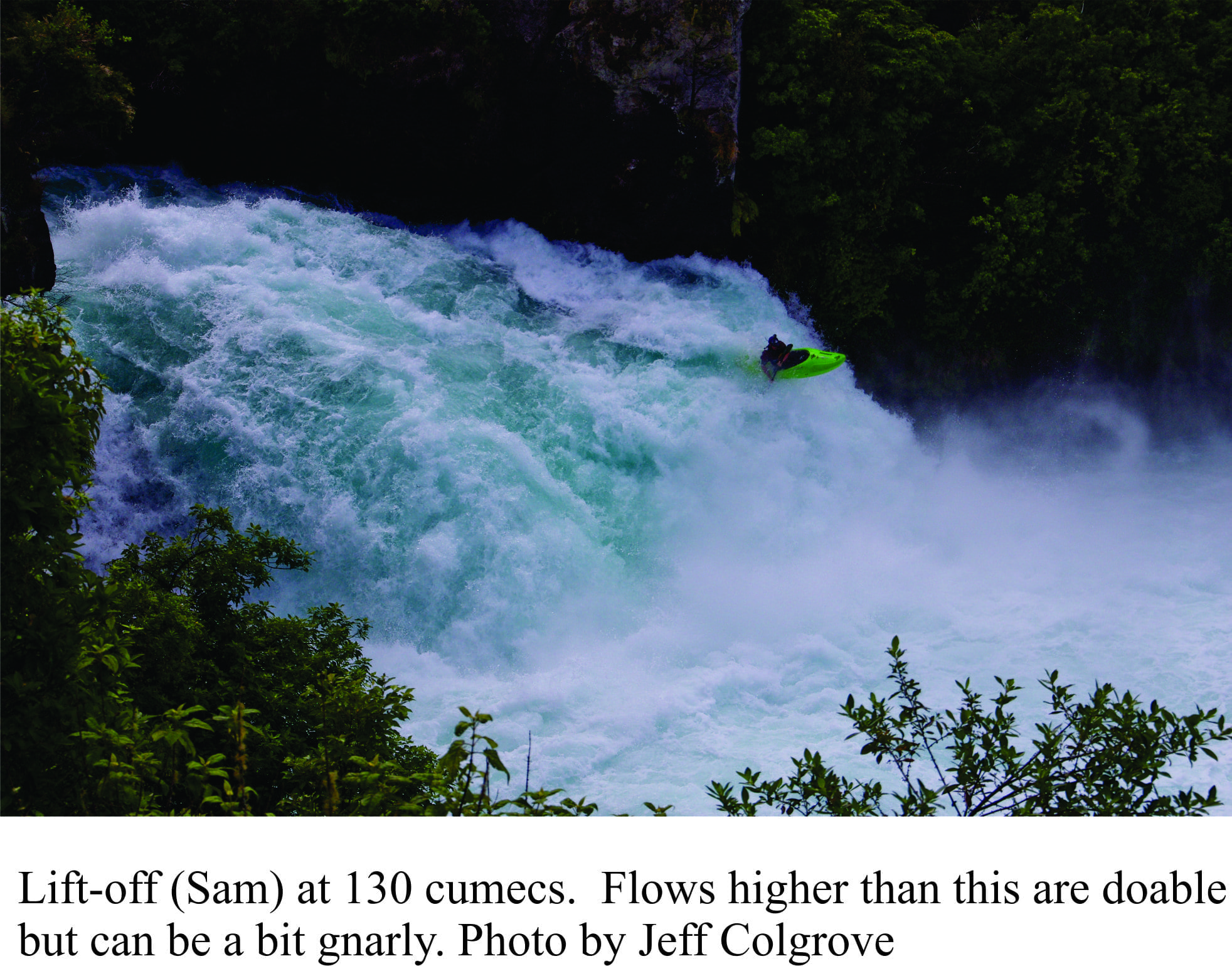
It has been hypothesized, based on geological mapping that the eruption blocked the outlet from the ancient lake. Breaching of this natural dam produced a surge of water that was funnelled down the valley now occupied by Waikato River. It has been estimated that the flow was about 20,000 to 40,000 cumecs (the modern flow averages 160 cumecs). Historical records from ancient China and Rome tell of brilliant red sunsets and darkening skies about this time that may attest to the global impact of the eruption.
There are some mind-boggling comparisons with other recent eruptions. The Taupo Eruption 1800 years ago erupted between 60-100 cubic kilometres of rock material. Mount St Helens in 1980 erupted less than 1 km3, Krakatoa in 1883 about 18 km3, and Pinatubo in 1991 5 km3.
Modern Lake Taupo
Despite their now tranquil temperaments, the Taupo and its near neighbours in the Rotorua area were all born from large eruptions during collapse of calderas. The calderas and all the other volcanic and geothermal activity form part of the Taupo Volcanic Zone (TVZ) that also includes the active Ruapehu-Tongariro-Ngaruahoe trio of volcanoes and offshore White Island. It is one of the most active volcanic regions in the world. There is still plenty of geothermal activity around Lake Taupo – there are several geothermal power generators in the area. Heat for this activity is derived mainly from the modern magma chamber that is about 8km deep. The region is monitored closely and constantly for any changes in heat or earthquake activity that might signal some kind of energetic resurgence. You can check the latest information on Geonet
Two links here provide a kind of guided kayaking tour
and some aerial views down Huka Falls
See also the geological-digressions.com Facebook page for regular updates of this series and other geology-related posts