
“Our water well taps into an underground lake”.
“There’s an underground river running beneath our property”.
“The river under our property comes from that volcano over there” (about 100km away)
These are just some of the explanations and descriptions of groundwater that persist in common discussion. Of course there are ‘underground rivers’ but they are generally restricted to limestone country, along with landforms like karst and sinkholes. But underground lakes…?
This, the 3rd post in the Groundwater Series looks at aquifers and groundwater storage
 Groundwater resides in aquifers and aquitards. Hydrogeologists have a pretty pragmatic definition for aquifers; an aquifer is any rock or sediment that stores and transmits water in usable quantities. An aquitard restricts water movement (but does not stop it altogether). The approximate equivalent terms used for oil and gas are respectively reservoir and seal.
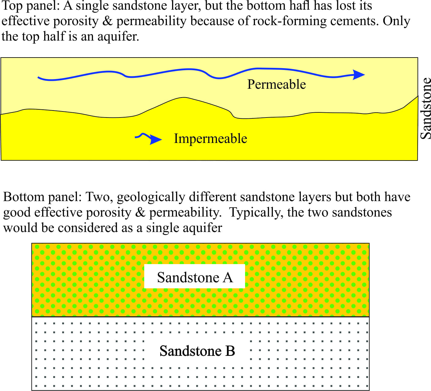
Aquifers that are most commonly utilized occur within layered sediment or sedimentary rock (commonly sand, gravel), and jointed-fractured bedrock such as lava flows and fractured granite. The extent and geometry of an aquifer depends on the extent and geometry of usable porosity and permeability and not necessarily on the extent of the rock units themselves. For example, a thick sandstone layer may have good permeability over part of its extent, and poor permeability elsewhere; hence only the permeable part of the sandstone is a usable aquifer (see the illustration above. Conversely, stacked sandstones where each is geologically different but has good permeability would typically be considered as a single aquifer.
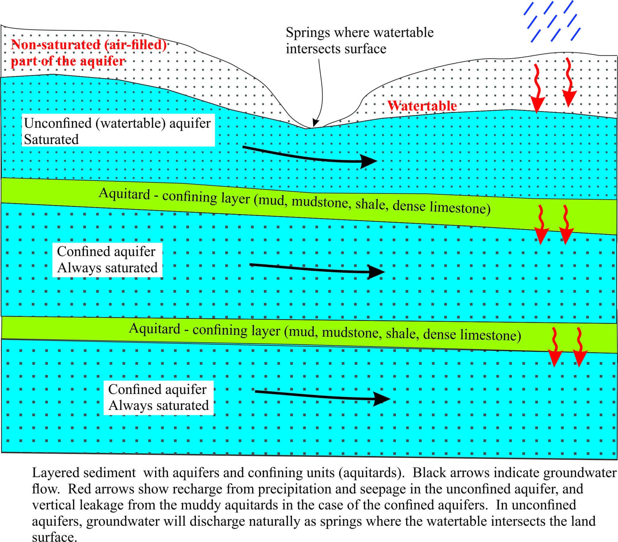
We define two main types of aquifer; unconfined, sometimes referred to as watertable aquifers, and confined aquifers. The distinction is very important because each type responds differently to pumping (discharge), recharge and risk of contamination.
Unconfined aquifers
Aquifers that have direct contact with the land surface are unconfined. Common settings for these aquifers are sands and gravels deposited on river floodplains and coastal plains. There are two parts to this type of aquifer:
- An unsaturated zone, where pores are filled (mostly) with air. The unsaturated zone is in direct contact with the land surface and air; thus air in the pores is close to atmospheric pressure.
- A zone where pores are filled with water – the saturated zone. The boundary between the saturated and unsaturated zones is the watertable
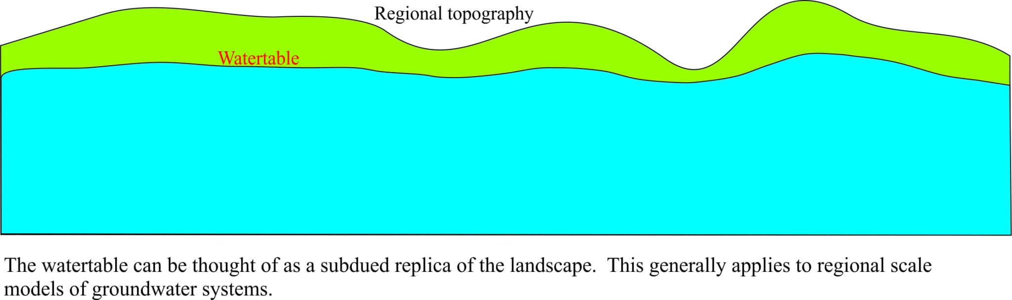
The watertable is a special kind of boundary. It is a 3-dimensional surface that mimics, in a subdued fashion, the land surface topography. Hence we can think of the watertable as having ‘hills’ and ‘valleys’ that coincide approximately with surface topography. The watertable is never horizontal; it has slope and it is that slope, or gradient, that provides the gravitational energy for groundwater to flow.
The watertable can also move vertically where the level can change several metres upward or downwards during seasonal changes in precipitation. Water well intakes and screen depths need to take these fluctuations into account. Watertable levels also are affected by excessive withdrawal of water by pumping. Note that this function of the watertable is fundamentally different to the behaviour in confined aquifers.
Unconfined aquifers are recharged by direct seepage of precipitation through the unsaturated zone; recharge rates typically vary from days to months. Recharge is affected by long-term changes in climate (such as extended drought), but it can also be reduced where surface runoff and seepage are redirected by city and town infrastructure (houses, roads, culverts etc.). The risk of contamination of unconfined aquifers is significantly greater than for confined aquifers because of potential infiltration directly through the unsaturated zone.
Confined aquifers
Aquifers that are separated from direct surface recharge or other aquifers by low permeability layers are referred to as confined aquifers. Confining layers, or aquitards typically consist of mud, mudstone or shale. Layered sedimentary (and volcanic) successions may contain many confined aquifers.
Confined aquifers are always saturated. Most confined aquifers are recharged by slow, vertical leakage from the overlying muddy layers; recharge is typically much slower than it is for unconfined aquifers – 10s, 100s and even many 1000s of years. Deeper parts of the High Plains Ogallala Aquifer take 6000 years to recharge; even more extreme, some parts of the Australian Great Artesian Basin may take 2 million years! Fluid pressures within the aquifer may change during pumping or long-term climatic fluctuations in recharge, but the aquifer never runs dry (unlike unconfined aquifers).
Unconfined and confined aquifers respond very differently to pumping
Removal of water from an unconfined aquifer takes place via drainage from pores; there are no significant changes in fluid pressure or structural changes to the grain framework. If the rate of abstraction is less than the rate of recharge then the watertable will remain reasonably static (notwithstanding factors such as seasonal changes in recharge). However, if the rate of water removal is excessive then the watertable will fall and the exposed pores will be air-filled. Importantly, this process is reversible.
In contrast, water removal from a confined aquifer results in: (1) a slight reduction in fluid pressure around the well, and (2) some rearrangement of the grains making up the aquifer framework. If water removal is excessive (i.e. greater than the rate of recharge) the framework grains will move much closer together such that effective porosity is reduced. This process is referred to as aquifer mining; it is irreversible, results in permanent damage to the aquifer and significantly reduced production of water. Grain repacking also results in reduced aquifer volume that gives rise to land subsidence. The classic photo from San Joaquin Valley shows about 8.5m of subsidence between 1925-1977; recent satellite imagery indicates up to 5cm/month in some areas of this valley. Some areas of New Orleans also are experiencing up to 50mm/month subsidence from groundwater withdrawal.
Excessive groundwater withdrawal from both types of aquifer is problematic in many parts of the world. Aquifer mining, land subsidence and the consequences for water supply and damage to city and town infrastructure, are not reversible although turning the taps off may slow these processes. One potential solution is to tap into deeper aquifers, but these are likely to contain older water and require significantly longer recharge times. Deeper, older waters also tend to become increasingly brackish as some mineral components of the rocks begin to dissolve. Contamination of groundwater is another global problem that is superimposed on these already stressed aquifers.
Of course, common sense dictates that we should look after our existing water resources – now there’s a novel thought!
Actually, “there is an underground river running beneath my property” might actually be true if you are in a karst aquifer, or even a pseudokarst, like you might get in basaltic rocks with lots of lava tubes. Ordinarily though, you are correct, but people persist in believing the underground river story.
Yes to both examples. Limestone country usually has caves as well as karst, and as Floridans in Polk County discovered, once again, in sinkholes that connect to the local aquifer. There are one of two wells in Auckland, NZ that have also tapped groundwater in lava-tubes.
Pingback: home page
An interesting article, Brian.
An interesting article Brian. The current urban myth in Penticton, BC, is that an “underground river” runs beneath the city joining Okanagan Lake with Skaha Lake. Hearing the myth repeated makes me wish I knew more about the local geology.
Drew, Nice to hear from you. What are you up to these days?