Tag Archives: Flaherty Island

The Burrens: An understated beauty

Facebooktwitterlinkedininstagram

Raised shore platform cut into Carboniferous limestone, Burrens, Ireland.

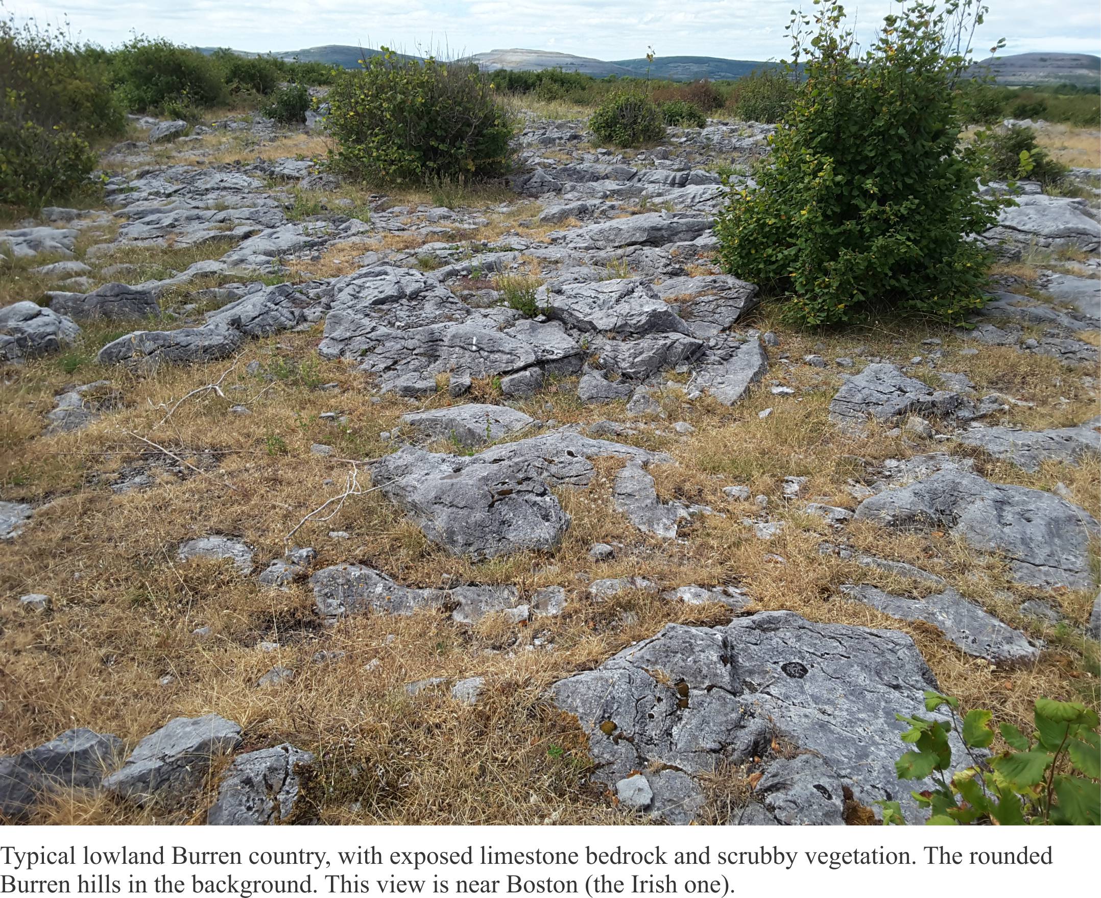
The Celts must have known a thing or two about rocks. They certainly recognized the bare hillslopes of western County Clare (Ireland) for what they were – Burren, an anglicized version of the Irish Boíreann (a stony or rocky place). Even the grasses and wild flowers in a myriad nooks and crannies, have trouble eking out a living. The lower hillslopes and valleys between these stony, limestone hills seem verdant (although the soils there must be alkaline), but the hills themselves…! Patchwork dry-stone walls ascend and encircle the hills, evidence of the optimism of farmers, the odd cow or horse searching for an elusive blade of grass. Whoever worked these stones are distant memories.

Typical Burren landscape and vegetation

The Burren and the Cliffs of Moher are a UNESCO Geopark (established in 2011). From a geological perspective, the two sites are diametrically opposed – one a cluster of bare limestone hills and the other, vertiginous coastal cliffs that are in a constant state of renewal from pounding Atlantic waves.

The limestones formed about 350 million years ago, part of the geological period known as the Carboniferous. Ireland back then was closer to the tropics; seas were warm and teeming with life. This was a time of relative stability, following on the heels of momentous events caused by continental collisions and mountain building – the Caledonian event. The present landscape was moulded more recently by a couple of glaciations, the last one ending about 10,000 years ago. During the Last Glacial Maximum, about 22,000 years ago (i.e the time of maximum ice accumulation), Ireland was covered by the Celtic Ice sheet (more or less a continuation of the Scandinavian Ice Sheet). Glacial ice plucked and scoured the hard limestone, leaving rounded hills and in places a veneer of ice-carried debris. It is a glacio-karst landscape, and it is the latter to which most visitors are drawn.

Limestone is naturally prone to dissolution, a process where calcium carbonate (CaCO3) dissolves slowly in rain and percolating groundwater. Over time (many 1000s of years), unique ‘karst’ landscapes evolve including rugged surface structures, sinkholes (also called dolines), and subterranean caves and streams. Karst landscapes are common in limestones exposed to humid tropical and warm temperate climates. The Burren is unique because its karst followed the retreat of glacial ice.

Clints and grykes - karst structures in Burrens limestones

Marine corrasion of limestone, Burrens, Ireland

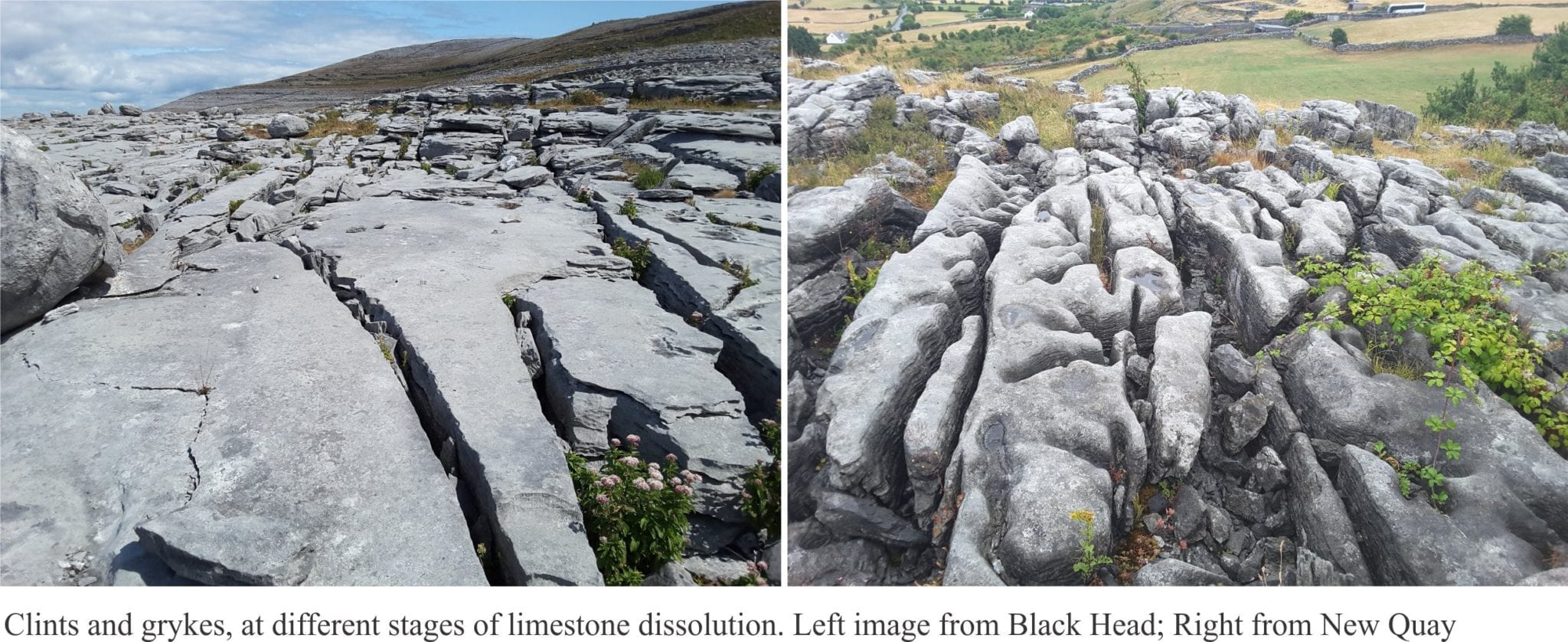
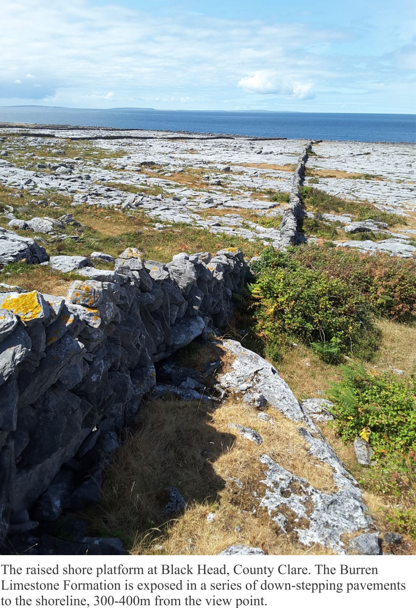
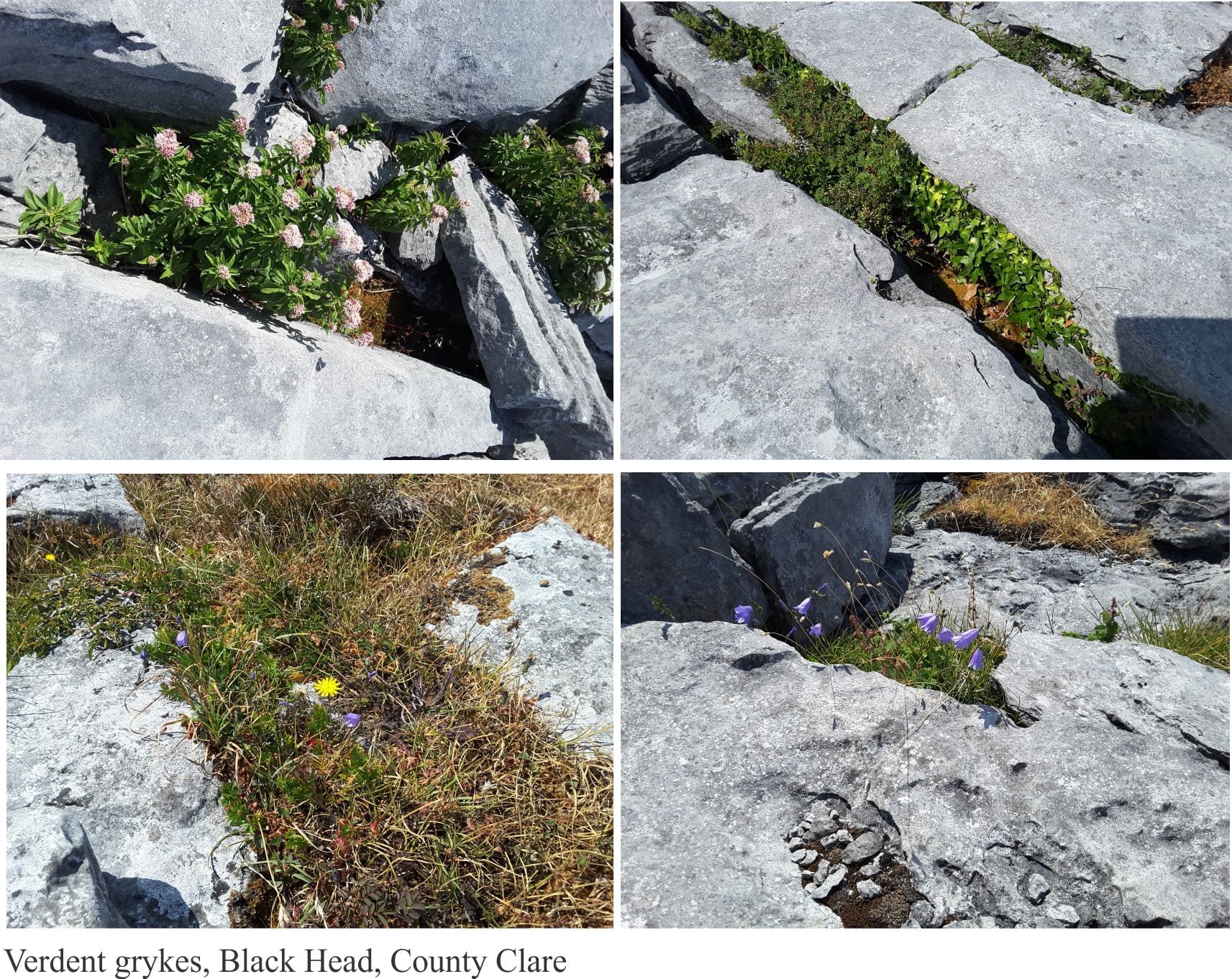
Scramble over any part of the Burren and the first thing you’ll comprehend is the need to watch your step. The limestone slopes and pavements are cut by myriad fractures, enlarged and deepened by the slowly dissolving limestone – these are the grykes, that separate the intervening limestone blocks, or clints. Clints and Grykes; the word clint is old Scandinavian (Viking) meaning summit or cliff; gryke (a variant of grike) – not much is known about this word other than it is from 18th century northern English.  Grykes focus surface water and hence are home to a wonderful array of flowers (including many orchids), grasses, small scrubby bushes and creepers (like ivy). Surface waters from rain and snow melt rapidly descend the gryke-riven limestone to become part of an extensive network of small, underground fracture flows and seepage, groundwater that emerges lower down the slopes, in valleys and along the shoreline.

Wild flowers in limestone grykes, Burrens, Ireland

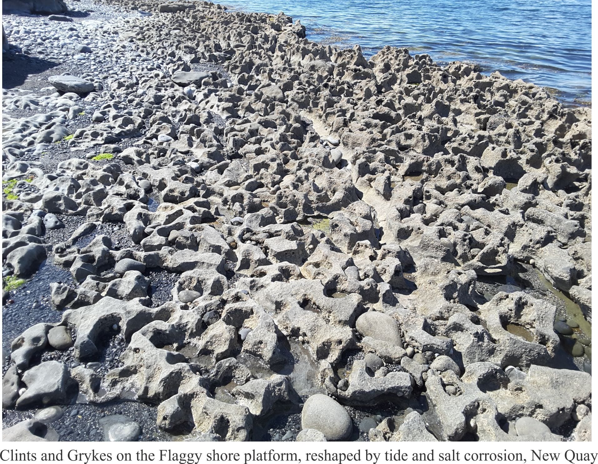
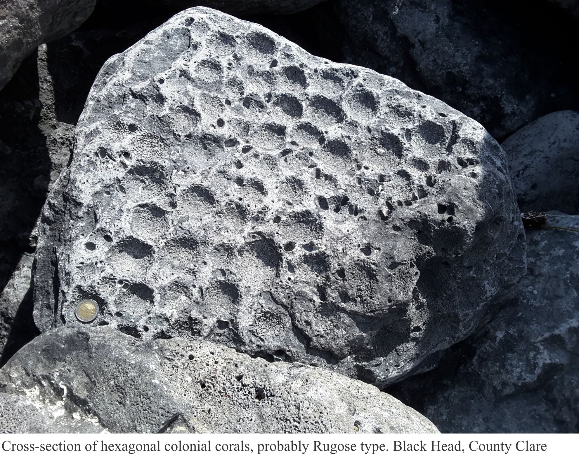
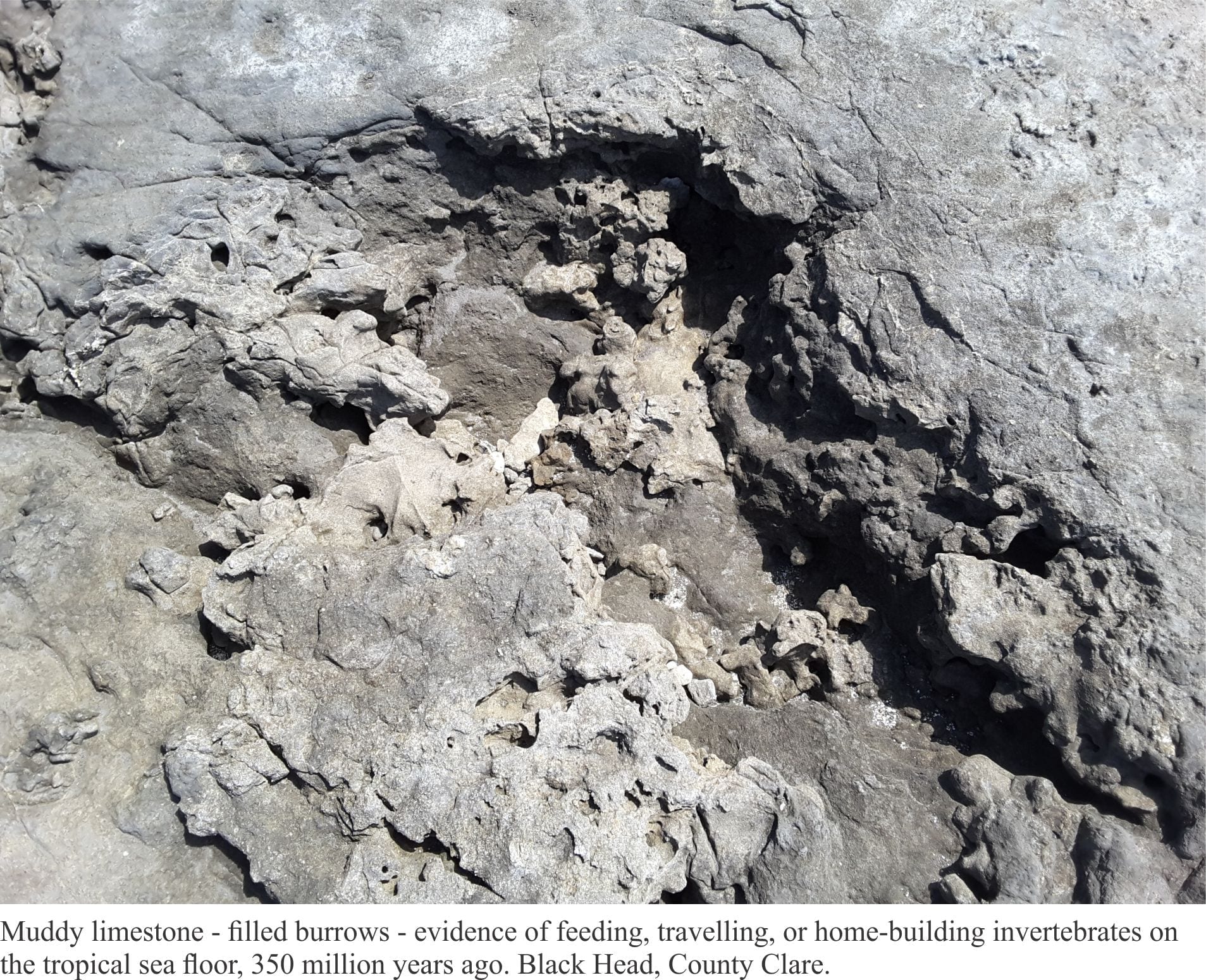
Burren limestones contain many fossils, and the best place to see these is along the shore, where waves have smoothed the rock surface. Two stretches of coastline we walked during our sojourn there, were Flaggy Shore near New Quay (and close to a Linnane’s, a delightful pub on the estuary), and Black Head, a promontory that is fully exposed to the Atlantic. Limestones at Flaggy Shore belong to the Tubber Limestone Formation; those at Black Head are the Burren Limestone Formation and are a bit younger. The limestone formation at Black Head appears step-like along shore and hillslope; the steps reflect the well-developed laying, or bedding.  Some of these beds are separated by thin layers of muddy or shaly rock. Back-stepping of layers at Black Head may have been accentuated by post-glacial uplift of the coast, a product of isostatic rebound following retreat of the ice sheet.

Coral colonies exposed in Carboniferous limestone, Burrens, Ireland


Detail of coral colonies exposed in Carboniferous limestone, Burrens, Ireland

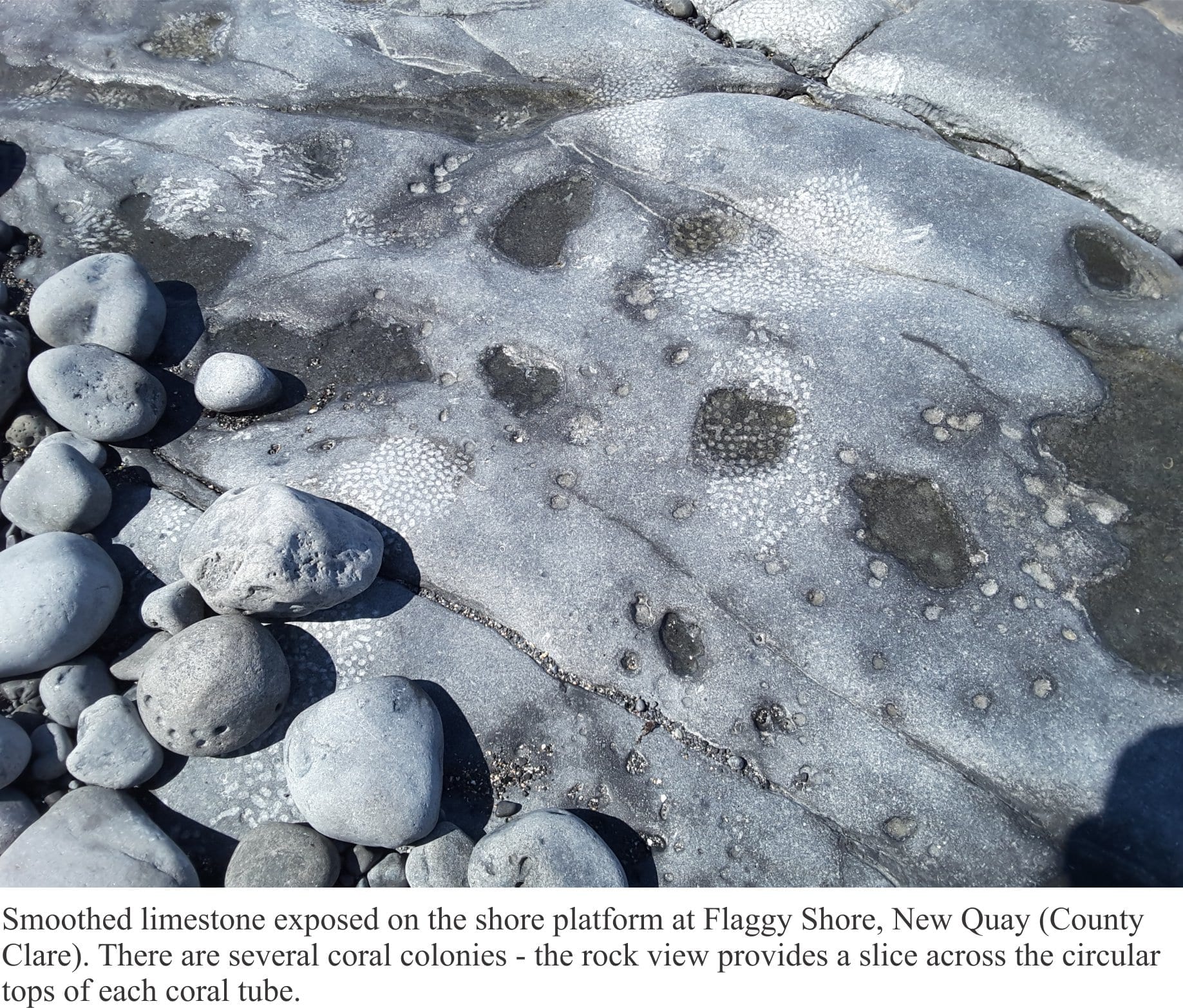
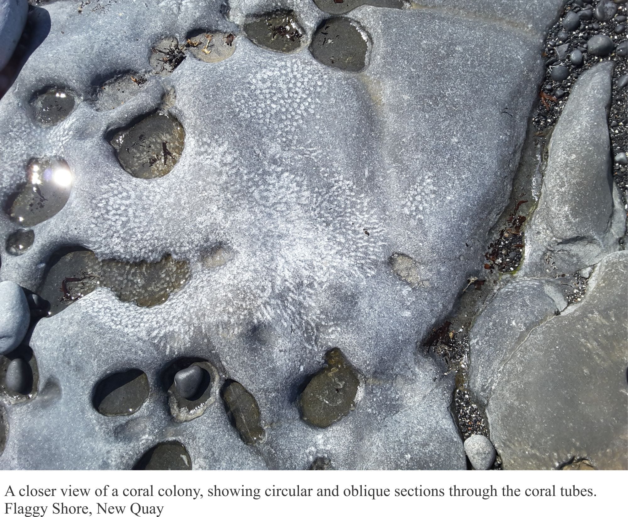
The most common fossils include brachiopods (sometimes called ‘lamp shells’, are invertebrates with two shells, superficially like clams, but having a completely different animal inside), corals, and gastropods (sea snails). There are also crinoids (distant relatives of star fish) but I did not see any of these. Corals are common along the coastal exposures, mostly in clusters of skinny branched colonies. Most have circular cross-sections, but we did find one example of a colony where individual columns had hexagonal cross-sections – a now extinct group known as Rugose corals. The exposures seen along the coast are like a slice through these colonies; this also applies to the brachiopods – rarely do we see the complete shells.

Weathered hexagonal coral colonies in Burrens limestones, Ireland

Mud-filled burrows in Carboniferous limestones, Burrens, Ireland

The Burrens are unlike anywhere else in Ireland. The expression ‘Emerald Isle’ doesn’t really apply here. Green fields and woodlands, the idyllic Irish scenes in tourist brochures and poetic verse, are replaced by grey hues that merge with cloud and sea. Even the dry-stone walls disappear in the tide.  As far as landscapes go, the Burrens are a bit understated; there’s none of the vertigo sensed at the Moher Cliff edge, no brooding mountains, just the quietude of a landscape that has withstood Atlantic battering. The Burrens are unique.

Facebooktwitterlinkedininstagram
Facebooktwitterlinkedin

In the field: from one extreme to another

Facebooktwitterlinkedininstagram

Aerial photo of Belcher Islands, Hudson Bay

Have you ever looked at some locale on a map or photograph and thought “that looks like an intriguing place to work”, only to find, sometime later that you are smack in the middle of that same spot?  Time-warp? Some god’s lap?

I was preparing to travel to Canada. The plan was to do a PhD, and because I had not long completed a Masters thesis on geologically very young sedimentary deposits, had entertained the idea that research on very old rocks would add a kind of symmetry to my geological outlook – from one end of the geological time-scale to the other.  In preparation, I borrowed The Geology of Canada, a weighty tome, and homed in on the Precambrian system (basically everything older than 540 million years).  What caught my attention were some squiggly-shaped islands about 150km off the southeast coast of Hudson Bay; the Belcher Islands.  Their shape belied some interesting geological structures, and the strata a mix of sedimentary and volcanic rocks about 2 billion years old. What a neat place to work, although I envisioned the islands to be treed.

I arrived in Ottawa (early January, 1976) to minus 25oC and snow; I had never seen so much snow. I thought it quite beautiful, which elicited wry comments from the Ottawans I was meeting who were sick of shovelling driveways and digging vehicles out of snow drifts. Destination – Carleton University. My supervisor was to be Alan Donaldson, well-known in Precambrian geology circles. Following the introductions, he announced that my project, unless I had some objection, was to focus on the Belcher Islands.  LOL. I was to spend 5 months there in total over the summers of 1976-77.  The social environment, the weather, and the geology were remarkable.

Plunging anticline-syncline folds, Mavor Island

Getting to the islands was a milk run: a drive to Montreal airport, a flight to Moosonee near the southern shores of James Bay (northern Ontario), a very noisy DC3 leg to Umiujaq (Quebec) where we picked up field equipment (kindly loaned to us by the Geological Survey of Canada), then Twin Otter across the 150 km to Sanikiluaq, the sole village on Belcher Islands. We were able to stay in a small house owned by the Hudson’s Bay Company for the two days needed to sort gear, buy food, and make sure the two inflatable Zodiacs and outboards worked. My assistants (John McEwan in 1976, Mike Ware in 1877) and I always used two boats as a safety measure (and for visitors).

Sanikiluaq in 1976

The seas around the islands are mostly ice-free during the summer months, but the water is still only a few degrees above freezing, and the air close to the water cold. Even in the summer, we had to bundle up with wet-gear, fleeces, and life jackets (I was told the life jackets were necessary for insurance purposes – so they could retrieve the bodies). The islands and intervening channels are also elongated north, so that wave set-up could change drastically any time there was a wind shift.  We were caught out a few times with unfavourable seas, but there was always somewhere to shelter.

Negotiating sea ice, 1977

Belcher Islands are mostly held together by a thick volcanic unit that creates more or less linear coastlines. The strata were folded, like a series of waves, into simple anticlines and synclines, such that the package of sedimentary rocks is exposed in the anticlines, while the synclines are drowned by major channels and inlets.  The terrain is subdued with low relief – the islands were scraped clean by the Laurentide Ice Sheet during the Last Glaciation.

Base camp on Tukarak Island - the local Inuit holiday spot

Our base camp was to be in a small, relatively sheltered inlet along the western shore of Tukurak Island (one of the largest and easternmost island).  It was a 3-4 hour journey, depending on weather.  This is the site of an abandoned Hudson’s Bay post. It was also the favoured summer holiday spot for local Inuit, primarily because it is close to their source of soapstone.  Belcher Island soapstone has an enviable reputation amongst northern communities, because of its uniform, deep green colour, and general lack of fractures that would render carving difficult. Whenever we were in base camp, we would watch the elders carving, and teaching their younger folk the same skills. They would also bring us bannock and Arctic Char. And there was never a shortage of Inuit kids around, checking in, telling stories, or simply hanging out. We would spend 4-5 days away from base camp, returning to stock up and cache samples. Time in base camp was always a delight.

Camp visitors, 1976


Davidee Kavik, soapstone carver on holiday on Tukarak Island

Belcher Islands sit well below the Arctic Circle at 56oN (latitude), and yet the landscape is typically Arctic. The northern Canada tree-line is located south of Hudson Bay, such that the Islands have a typical Arctic flora (especially wild flowers), and no trees – so much for my earlier, wistful image of the place.

The weather alternated between gorgeous, with light winds and clear skies, and abysmal. On more than one occasion we returned to camp from a day’s work to find tents down and sleeping bags soaked.  High winds also prevented longer excursions with the boats, unless we were riding through sheltered channels and inlets.  With the boats, there was always one eye kept on the weather.

During the first couple of weeks in 1976, Bill Morris (Geological Survey of Canada) had joined us to sample rocks for geophysical measurements (looking for ancient magnetic poles). The day he was to leave base camp (and fly out of Sanikiluaq) was particularly inclement. He insisted on attempting the trip, but instead of using our inflatable boats, I decided to rent one of the larger, sturdier, Inuit canoes with twin outboard motors (I was the only one with boating experience). We ventured out of the sheltered inlet, into the maelstrom – at least that’s what it looked like from the perspective of our small craft. I doubt we got any further than 50m from the inlet entrance; a lull in the waves, a quick decision to about-face, a beeline back to calmer waters, and the colour returned to the faces of my two passengers.

“Guess I’m going to miss my flight”. We all new he probably would have missed it, even if we had continued. Back to base camp to drain what was left of a bottle of scotch, and cogitate on an earlier field season on a warm New Zealand Pacific coast.

This is the first blog on my Belcher Islands episode

Facebooktwitterlinkedininstagram
Facebooktwitterlinkedin