May 18, 1980, a crisp, clear Cascade mountains morning was rent by the catastrophic eruption of Mount St. Helens. Fifty seven people were killed by the initial eruption blast. Lives and landscapes were changed irrevocably.
Mount St. Helens is one of several historically and prehistorically active volcanoes in an arc stretching from northern California to southern British Columbia – about 1100 Km. The first signs of awakening began March 16, 1980 with a burst of seismic activity, followed on March 26 by a small eruption that produced some ash and steam – the first such eruption in 100 years. Small eruptions (small by comparison with what was to follow) continued off and on into May. For the two months prior to May 18, geologists and seismologists monitored the volcano; measuring its earthquakes (1000s of them), the changing shape of its summit, and changes in heat beneath the ground.
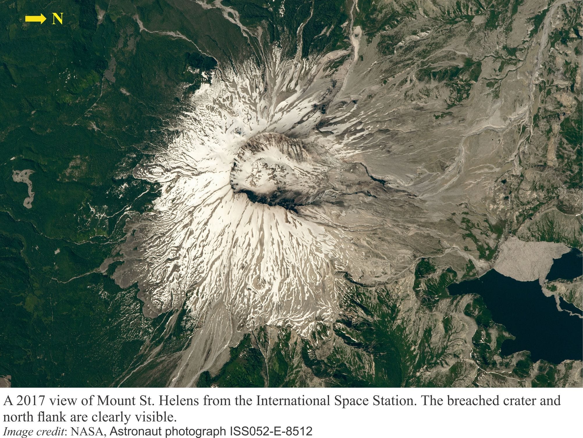
Over this period, rising magma caused the north flank of the edifice to bulge – photos taken just prior to the main eruption show dramatic changes in the land surface along this flank. As it turned out, the accumulating magma was acting as a kind of pressure-relief valve. At 8.32 am a magnitude 5.1 earthquake dislodged the intruded magma, causing the northern flank to collapse in a massive landslide. The main body of the landslide was mobile enough to travel 22 km down the adjacent valley.
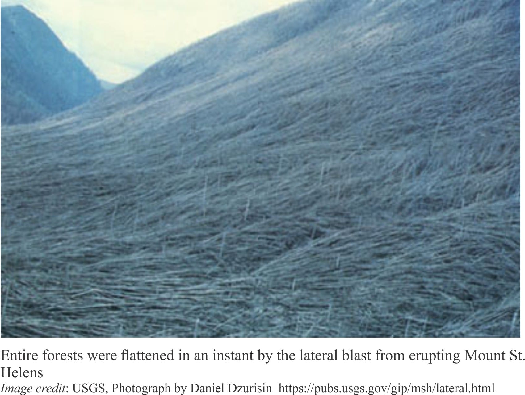
Failure of the north flank effectively opened the vent pressure valve – commentators frequently liken this process to the popping of a champagne cork. Two things happened:
- Pressure release across the volcano flank produce a catastrophic blast of hot gas, ash, and large rocky ballistics that moved laterally (this phenomenon is called a lateral blast), flattening everything in its path. The ground-hugging ash flow swept up ridges and through valleys, at speeds up to 480 km/hour.
- Within a few minutes the main eruption column had risen 24 km above the Earth’s surface. Some of this ash fell back onto the volcano’s flanks producing pyroclastic flows – albeit smaller flows than the initial lateral blast. Over the next 15 days, ash and aerosols that entered the upper atmosphere had circled the Northern Hemisphere.
Millions of tonnes of ash covered western US states and southern Canada. Debris from the landslide and lateral blast blocked rivers and created new lakes. Subsequent snow melt and rain moved much of the loose ash into rivers, creating new hazards in the form of highly mobile mud flows, or lahars. These kinds of problems continued for years following the main eruption.
The 40th Anniversary of the eruption, the lives lost, and lives changed, are remembered in webinars, documentaries, old footage and images, by scientific organizations and the media (mainstream and social). I have listed a few below.
Some links to really good MSH resources:
The United States Geological Survey was and remains a key player in volcano monitoring. 40 Years Later: The Eruption of Mt. St. Helens and the USGS Response: Overview
The Smithsonian Institute has an excellent list of webinars and activities that will appeal to all ages and interests
The University of Oregon has a webinar
University of Washington – Seismologists to host virtual event on 40th anniversary of Mount St. Helens eruption
Washington State Parks – Honoring the 40th “Eruptiversary” of Mount St. Helens
NASA Earth Observatory has some great images of Mt. St Helens from various satellites and the International Space Station
Voices of Volcanology is a Facebook group dedicated to keeping everyone updated on volcanoes, volcanic activity, and myth-busting (like all those stories on the Yellowstone supervolcano). Here is a great example where Janine Krippner interviews Dr. Seth Moran, the scientist-in-charge of the Cascades Volcano Observatory.