Tag Archives: plate tectonics

Marie Tharp and the mid-Atlantic rift; a prelude to plate tectonics

Facebooktwitterlinkedininstagram

Map of North Atlantic mid-ocean ridge

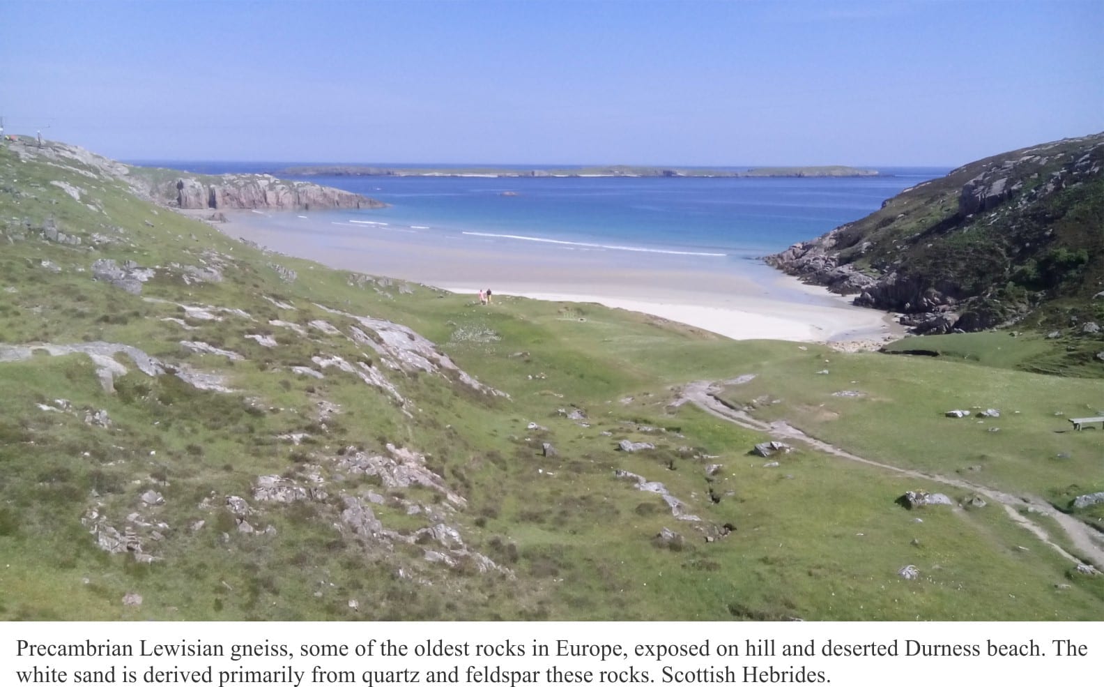
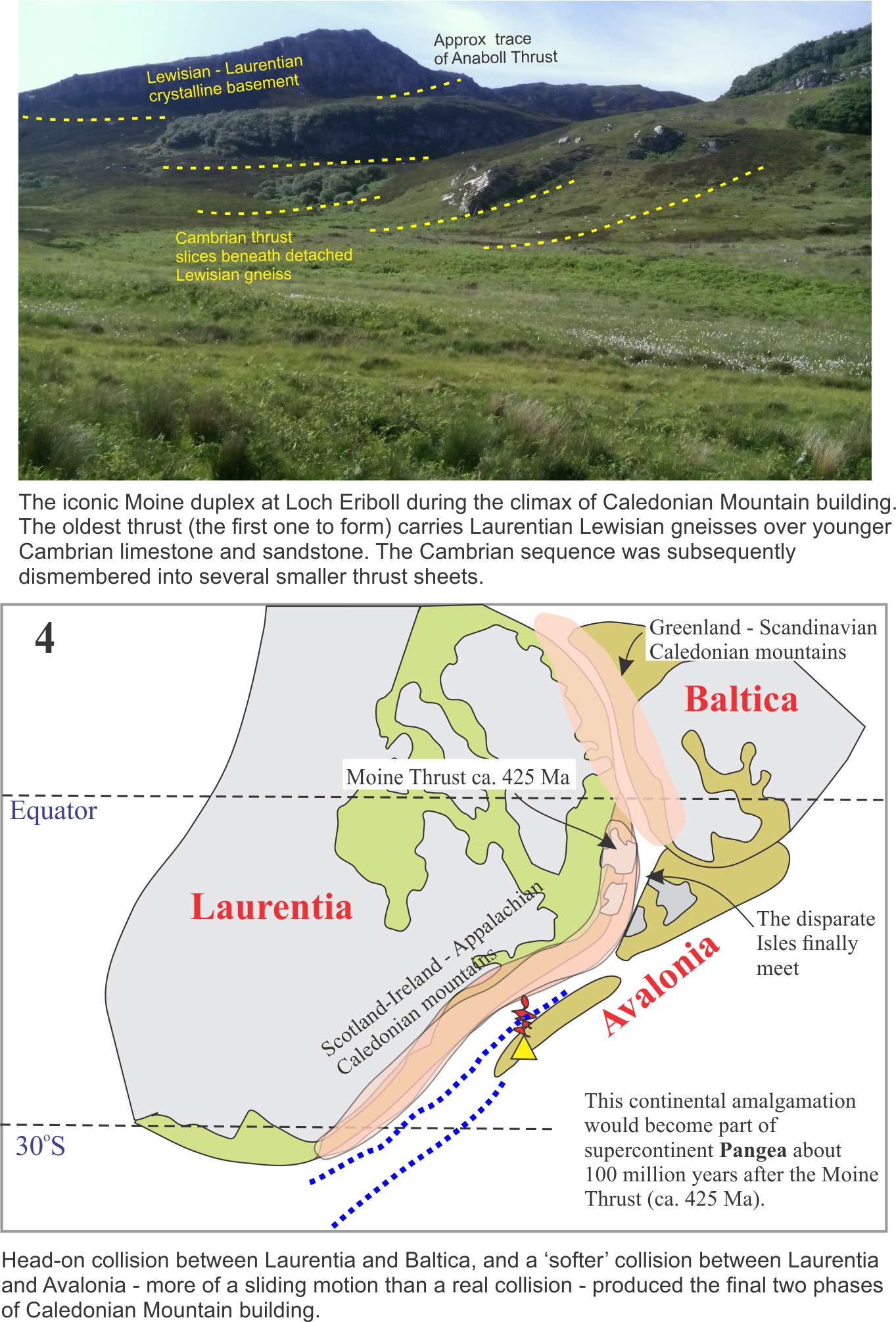
The history of science is littered with the misplaced contributions by women, contributions that at best were pushed aside or ignored, and at worst thought of as shrill outbursts. Witness:

as corrections to a history where women found it difficult to escape the status of ‘footnote’. We can add Marie Tharp (1920-2006) to the growing list of corrections. In 1952 Tharp discovered the central rift system in the mid-Atlantic Ocean ridge (that later would become a critical component of sea floor spreading and plate tectonics) but for many years was regarded as a minor player in the burgeoning, post-war field of oceanography.

During the War, Tharp in her early twenties took advantage of opportunities to engage in university study, openings in science and engineering left by men who had gone to battle. She completed a Master’s degree in geology, but given that geology is a field-based discipline, and that women weren’t supposed to go into the field, she extended her studies to a Master’s in mathematics. In 1948 Lamont Geological Laboratory (now Lamont Doherty Earth Observatory) hired 28 year-old Tharp to draft maps of the Atlantic ocean floor, based on the growing database from SONAR and historical soundings. She worked with well-known geologist-oceanographer Bruce Heezen, who spent much of his time at sea. It must have been tedious work, but she counted herself lucky to have a position at all. This was a time when very few American universities (or anywhere else for that matter) offered science and engineering positions to women; a time of patriarchal condescension – “Mad Men” versus “Hidden Figures”.


Graphical description of SONAR
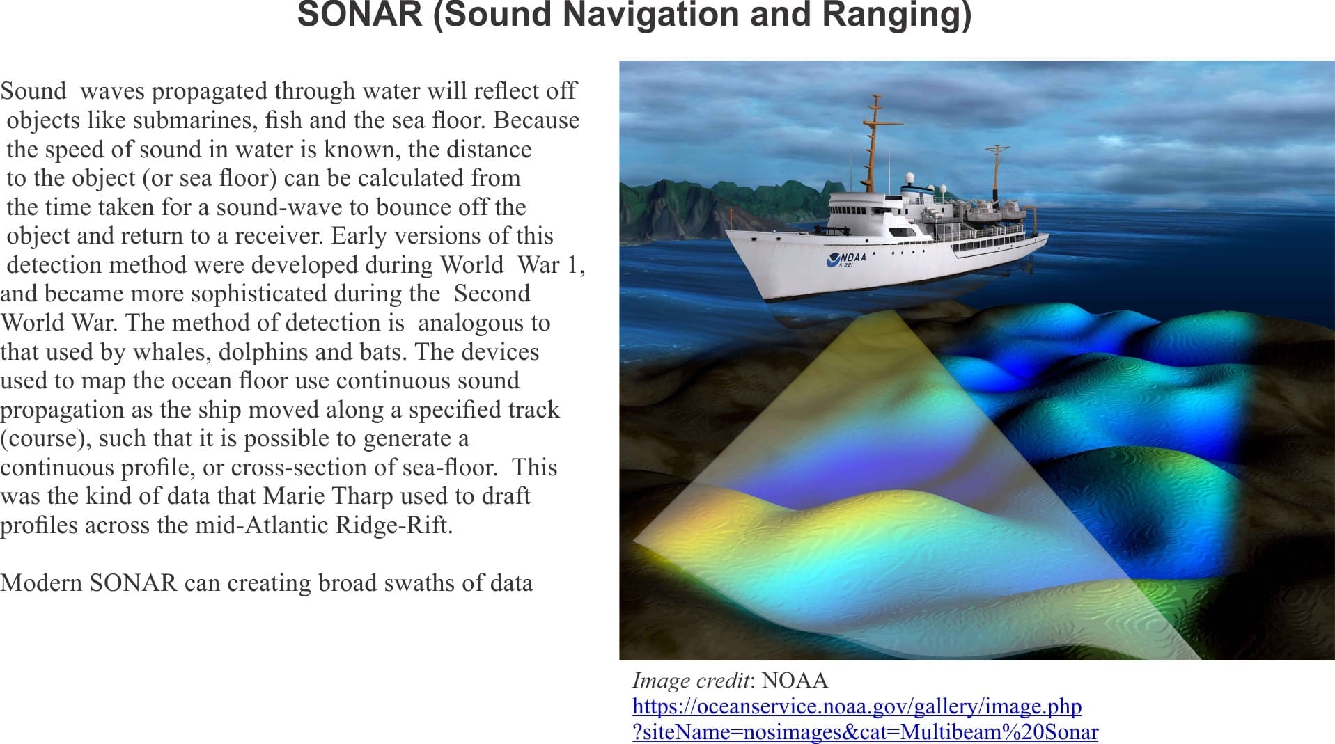
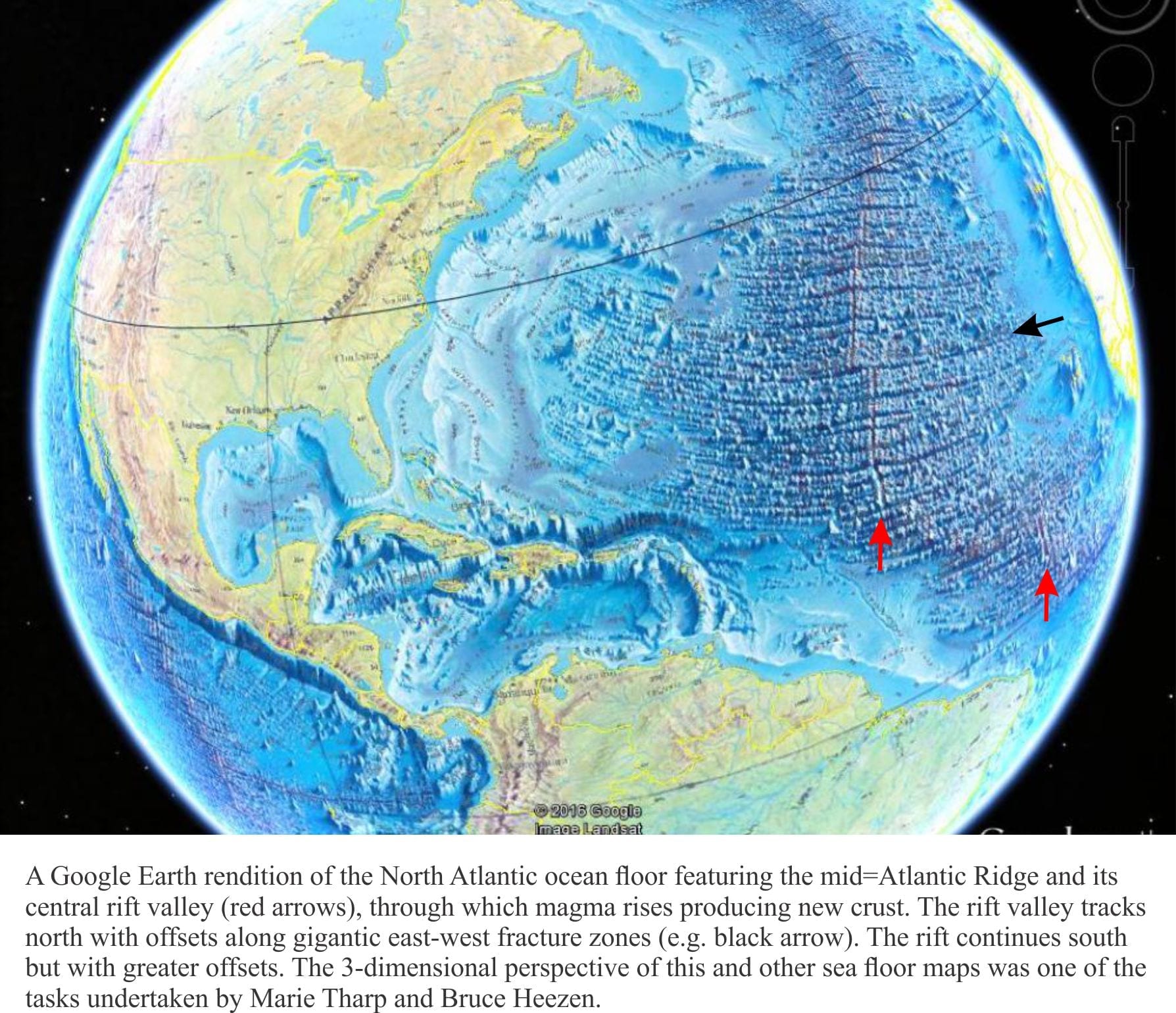
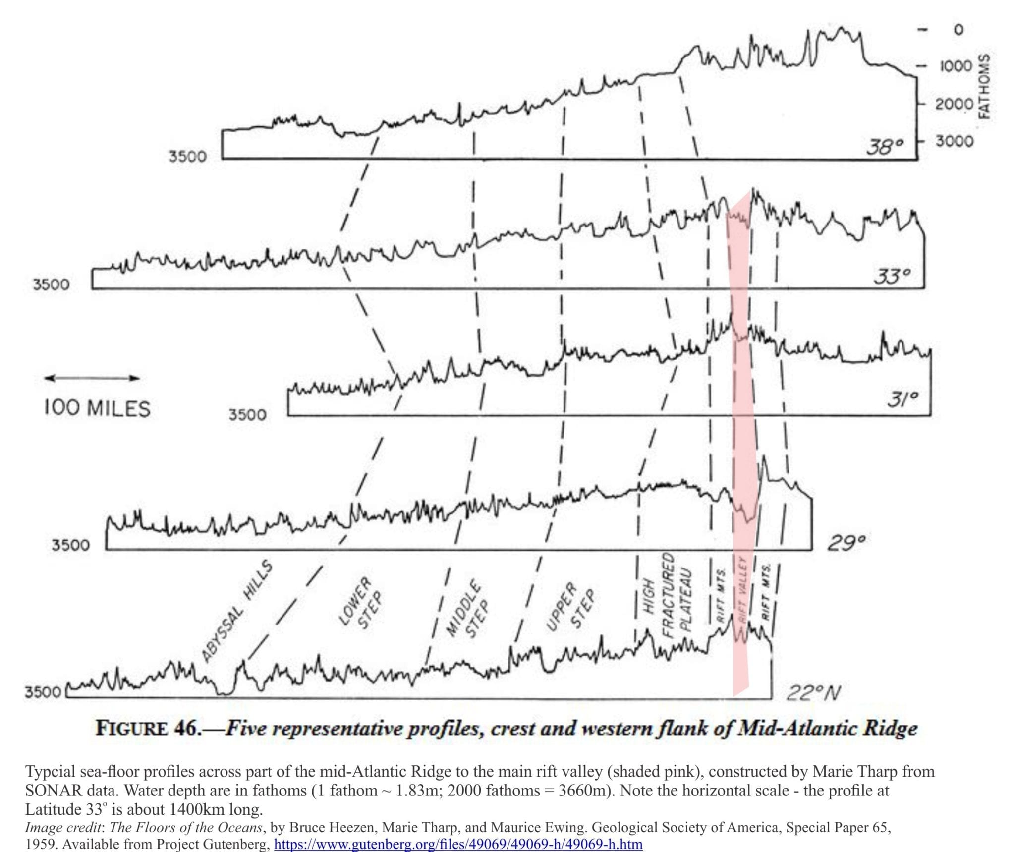
Tharp poured over depth and positional data for years, constructing 2-dimensional profiles of the Atlantic Ocean floor. She was aware, as other oceanographers were that an elevated region of sea floor apparently separated east and west Atlantic. This was initially mapped in 1854 by US Navy oceanographer, geologist and cartographer Matthew Maury, and later confirmed with depth soundings taken during the HMS Challenger expeditions (1873-1876 – Challenger had 291 km of hemp onboard to do this kind of thing; the ridge is generally deeper than 2000m). Tharp wasn’t surprised to find the Atlantic ridge on her profiles. What did catch her attention was the rift-like valley in the central part of the ridge; a geomorphic structure that was consistent through all her profiles. She immediately recognized the importance of this, because it implied significant extension, a pulling apart of Earth’s crust in the middle of the ocean. At the time, the general consensus was that ocean floors were relatively benign, featureless expanses. Her discovery indicated otherwise.


Some of the bathymetry profiles mid Atlantic used by Marie Tharpe

According to Tharp’s bio the response by Heezen and his colleagues was that she was being a typical woman – you know, “girl talk”. One can imagine the coffee room banter; ‘she’s great at drafting cross-sections but should leave the interpretation to the more learned’.

However, after some months and more profiles all showing the same rift- like structure, Heezen gradually accepted that this was real. A turning point for Heezen was the coincidence of several mid-ocean earthquake epicenters along the ridge. This was mid 1953. He understood its potential significance, particularly for those who thought that the hypothesis of continental drift had some credence (Heezen was not initially one of those people).

Ocean bathymetry studies in other basins in the early 1950s (Indian Ocean, Red Sea) revealed similar mid-ocean rifts. Tharp had by this time surmised that a rift valley coursed its way almost continuously the entire length of North and South Atlantic, a distance of 16,000 km; it was the largest continuous structure on Earth. The Lamont Doherty group gradually realized that the Atlantic structure, together with those discovered in other ocean basins, represented a gigantic Earth-encircling system of mid-ocean rifts, more than 64,000 km long.

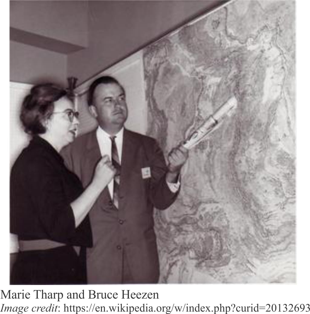
Heezen presented their research to a 1956 American Geophysical Union conference in Toronto. Marie Tharp barely received a mention. She did co-author a few subsequent publications as an ‘et al.’, but it was a kind of ‘also ran’; the accolades and approbation went Heezen’s way.

Tharp was fired by the Laboratory, the victim of a spat between Heezen and Lamont boss Maurice Ewing, but she continued to develop the maps at home. Marie continued to work in the background, as the humble and grateful recipient of a job she considered to be fascinating; “I worked in the background for most of my career as a scientist, but I have absolutely no resentments. I thought I was lucky to have a job that was so interesting”.

Marie Tharp and Bruce Heezen

Marie Tharp was named one of the four great 20th century cartographers by the Library of Congress in 1997, was presented with the Woods Hole Oceanographic Institution Women Pioneer in oceanography Award in 1999, and the Lamont-Doherty Heritage Award in 2001.

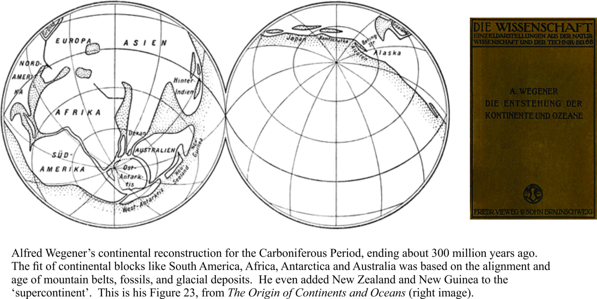
There is no question that Tharp’s discovery influenced the promotion of Continental Drift in the geoscience community. Alfred Wegener’s bold hypothesis (1915) had one major problem – there was no known mechanism that could move oceanic crust and continents around, like some precursor shuffle to a jigsaw puzzle. In 1929 Arthur Holmes posited a mechanism that involved large convection cells in the mantle, but this too lacked an important degree of empirical verification. Discovery of the mid-Atlantic rift provided a solution to this vexing problem, and in 1962 Harry Hess proposed that new magma, via mantle convection cells, was erupted from mid-ocean rifts allowing oceanic crust to spread outwards. This was Sea Floor Spreading, a precursor to the grand theory of Plate Tectonics – the tectonic shift in geological thinking wherein oceanic crust is created at mid-ocean rifts and consumed down subduction zones, with the continents playing tag.

Marie Tharp’s doggedness in her belief and understanding of mid-ocean rifting is now celebrated. It’s taken a few decades, but she is no longer a footnote.

Facebooktwitterlinkedininstagram
Facebooktwitterlinkedin

Bits of North America that were left behind

Facebooktwitterlinkedininstagram

Precambrian Lewisian gneiss exposed at Durness, Scottish Hebrides.

How bits of ancient North America (Laurentia) were left behind in the Scottish Hebrides.

The jigsaw puzzle of continents and oceans, the ground beneath you, the seas beyond, even the weather you enjoy or endure, are governed largely by plate tectonics. This grand mechanism creates plates along mid-ocean volcanic ridges, then proceeds to push them down the throat of subduction zones. Plates collide, tearing at each other’s crust. Volcanic hiccups, earthquakes, and crustal dismemberment are all part of a tectonic plate’s stressful life. And occasionally in this mad nihilist rush (after all, millimeters per year is pretty quick), bits are left behind.

The landscapes of north Scotland and northwest Ireland are underpinned by rocks that once belonged to North America, or at least an ancient version of it. As geological puzzles go, they are iconic; here James Hutton unraveled the problems of deep time, and Peach and Horne sliced the ancient crust into moveable slabs. The rocks are part of the Caledonian Orogen, a mountain chain that formed from tectonic plate collisions more than 400 million years ago, stretching from Scandinavia to Scotland-Ireland, east Greenland, and the Appalachians of eastern USA and Canada.

The choice of a starting point for a story like this is a bit arbitrary because continental and oceanic plates, and the plate tectonic mechanisms that propel them across the globe, date back at least one billion years, possibly earlier. For convenience, this tale begins on the ancient continent of Laurentia about a billion years ago; Laurentia was an amalgam of North America, Greenland, and (what would become) north Scotland and northwest Ireland tucked along its eastern margin [The first four figures here are modified from an excellent technical summary of this important period in Earth’s history, by David Chew and Rob Strachan, their Figure 1, in Geological Society of London, Special Paper 390, pages 45-91, 2014].

Unconformity between Lewisian Gneiss and Proterozoic Torridonian sandstone

Three groups of rock that underpin the Scottish Highlands, originally formed along the eastern Laurentian margin. Lewisian gneisses. Some as old as 2.7 billion years, were part of the basement foundations of Laurentia (Panel 1 above). Two major groups of sedimentary rock were also deposited along the eastern margin – the Moine group of rocks, that beneath the Northern Highlands we now see as metamorphic rocks, originally formed as sediment shed from the ancient continent about 1000 to 870 million years ago. Dalradian metamorphic rocks that now form the Grampian Highlands also originated as sediments and volcanics from about 800 to 510 million years – metamorphism occurred much later.

For the next few million years Laurentia moved south (south of the Equator!) towards, it is hypothesized, a volcanic arc, similar perhaps to modern Ring of Fire volcanic arcs that rim the Pacific Ocean (Panel 2). Collision between Laurentia and the Grampian Arc initiated the first phase of Caledonian mountain building 475-465 million years ago (Panel 3).

Several other events were also taking place at this time. Laurentia itself was rotating anticlockwise. Two smaller continental plates appeared on the scene: Baltica (that would later become Scandinavia and north Europe), and Avalonia (whence the rest of England, Wales and south Ireland resided), both were migrating north towards Laurentia. The intervening ocean, the Iapetus, was gradually shrinking as its crust was devoured down at least three subduction zones (Panel 3).

The Iapetus eventually closed; some slivers of oceanic crust (called ophiolites) were scraped off and incorporated into the Caledonian mountain complex, but most of this once-grand ocean basin was consumed in Earth’s grand recycling depot.

Baltica and Laurentia were involved in head-on collision around 435-425 million years (Panel 4). The Moine thrust, one of the defining ‘moments’ of tectonic dislocation and metamorphism in the Caledonian, developed during this interval. In contrast Avalonia’s approach was more oblique and it appears this smallish continental fragment slid past Laurentia. Avalonia’s legacy is that south England, Wales and south Ireland were now stitched firmly to their northern cousins. This plate tectonic assemblage has withstood tempests, bolides, and glaciations for the last 400 million years; 2000 years of geopolitical ructions are insignificant in comparison.

Moine duplex at Loch Eriboll, thrusting during the Caledonian Orogeny

The amalgamation of Laurentia, Baltica and Avalonia eventually became part of a much larger continental mass, a super continent called Pangea that included Africa, South America, Antarctica, Australia and Asia (and of course, New Zealand). This amalgamation was well underway 335 million years ago. Pangea began to break apart about 175 million years ago, a separation that over the next 175 million years would give us our most recent plate tectonic configuration of ocean basins and continents (Plate 5).  Break up of Pangea took place in several stages, but the event that is of interest here took place about 75-80 million years ago. [Chris Scotese has created an excellent animation of these events, set to nice music].

Plate reconstruction for 94 Ma

Atlantic Ocean had its beginnings during the early stages of Pangea break up, 175 million years ago. Atlantic Ocean’s expansion is centered along a submarine spreading ridge of volcanism (that today stretches from Iceland almost to Antarctica). The spreading ridge migrated northwards, which means that new ocean floor was also being created incrementally northwards. During the early stages of North Atlantic Ocean expansion, the British Isles were still firmly attached to the old Laurentia margin.  But by 80 million years the locus of spreading had moved west of Britain and Ireland (Plate 5), and it was at this point that the ancient roots of north Scotland and Ireland became divorced from North America and Greenland – a decree absolute.

The period of Caledonian mountain building is one of the most studied in the geological community (at least two centuries worth, and 100s of 1000s of scientific papers), much of it undertaken before plate tectonics was discovered in the mid-1960s. Nevertheless, plate tectonics theory has provided a more global context, and a more rational, mechanistic approach to solving the myriad geological complexities.

I recently visited some of these rocks in the Scottish Hebrides and Connemara – and yes, there is complexity at every level of observation. The story I have presented is simplified – perhaps woefully so. But even a simple rendition can promote understanding. I’d like to think so.

Facebooktwitterlinkedininstagram
Facebooktwitterlinkedin

There are two sides to every fault

Facebooktwitterlinkedininstagram

Hutt Valley, Wellington and the major spur of Alpine Fault running through the middle of the city

In 1940-41, Harold Wellman, a creative but somewhat irreverent New Zealand geologist, along with his colleague Dick Willett, discovered a remarkably long, linear fault striking slightly oblique to, and a few kilometres landward of the South Island west coast; almost the entire length of the island. They called this massive structure the Alpine Fault. The Fault can be traced overland some 600 km, about 450km of this is a more-or-less single fault strand; at its northern extent the fault splits into several strands, all of which are active.

Alpine Fault across South Island, NZ, from space

Most New Zealand geologists in the 1940s had little problem with a structure like this – admittedly it was very long, but most were familiar with faults, especially active ones.  By 1948 it had generally been accepted by the scientific community. The community did however have an issue with Wellman’s next discovery.  He realised that a certain group of rocks in the southern part of South Island (Otago region), were almost identical to a group at the north end of the Island (Nelson region).  He postulated in 1949 that these two geological domains were once a contiguous unit but had been separated some 500km by the Alpine Fault.  To many geologists at the time, this was going a bit too far, and it took several years to dispel the initial disbelief, and perhaps the odd conniption fit; one of the main criticisms was the absence of any reasonable mechanism to accomplish this geological feat. This was pre-Plate Tectonics, a time when many earth scientists still considered vertical movements of the earth’s crust to be the most important (although Alfred Wegener’s ideas on Continental Drift were discussed – it seems that Wellman was quite keen on this hypothesis). Fast forward to 1965 and a paper by J. Tuzo Wilson published in Nature, described a “New Class of Faults…”; Transform Faults.  Wellman’s discovery was about to acquire a mechanism, and become an iconic part of the new Plate Tectonics.

All plates identified by Plate Tectonic theory have boundaries, of which there are three basic types:

  • Spreading ridges and rifts, where upwelling magma creates new crust that moves away from the ridge,
  • Deep ocean trenches where two plates converge, forming a subduction zone that recycles old crust and mantle, and
  • Transform faults where two plates slide past one another. Most of this sliding is horizontal. If the movement between two massive slabs of crust and mantle were continuous then there would be few problems, other than a gradual (mm/year) change in one’s property boundary lines. But most movement along these fundamental structures is not continuous or uniform; it takes place in fits and starts – during earthquakes that commonly are very high magnitude, destructive events.

The Alpine Fault, and its close relative San Andreas Fault on the other side of the Pacific Ocean, are transform faults.  They each mark a boundary between two plates – if you walk across the San Andreas fault you pass from the Pacific Plate to the American Plate; over the Alpine Fault, from the Pacific to the Australian Plate.  There aren’t many places on earth where one can easily straddle two tectonic plates; these two transform faults provide great opportunities to become one with plate tectonics.

The Alpine Fault is geologically young.  The 500-km fault separation of the two geological domains began about 25 million years ago; from a geological perspective, this is really fast – for tectonic plates.  The west side of the fault moves northwards relative to the east side; it is referred to as a dextral (right-moving) strike-slip fault. At the same time, stresses acting Nicely folded schists, uplifted and erodedagainst the fault have uplifted the landmass; over the last 12 million years, rocks formerly 20-30km deep, were pushed to the surface, forming the Southern Alps.  Coincidentally, erosion and glaciation have carved the landmass into the rugged mountain range that extends almost the full length of South Island. Averaged over the last 2 million years, the central part of the Alpine Fault has moved horizontally at a phenomenal 27mm/year, and vertically at 10mm/year.  It is thought that this extreme displacement of the earth’s crust is the result of large, M (magnitude)7.5 to M8 earthquakes occurring every 200-400 years, the most recent in 1717AD.

At its northern extent, the Alpine Fault splits into several large, active faults, some heading offshore, others into the southern North Island (the North Island Fault System) and these have been the focus of many destructive earthquakes in the M6 to M8 range.  More than 6m of horizontal displacement registered the M7.8 event along Kekerengu Fault in November 2016 (Kaikoura earthquake).  On January 23, 1855, up to 18m of horizontal displacement occurred during the Wairarapa Earthquake, estimated to have been M8.2 – M8.3.  The epicentre was only a few kilometres south of Wellington city, which suffered significant damage although few fatalities; there was also a tsunami that in places had a 10-11m run-up.

San Andreas Fault3D perspective of San Andreas Fault from Spce Shuttle imagery is another iconic example of earth’s major fractures, and probably the most intensely studied. It is about 1200km long, and like its New Zealand counterpart, consists of a master fault with many divergent, active and inactive fault strands. It began to move things around about 28 million years ago and has continued to do so ever since, coming to public prominence on April 18,1906 with the San Francisco M7.7 to M7.9 earthquake (and subsequent conflagration); one of the largest events along this fault.  Earthquake recurrence intervals vary along the San Andreas fault system; in the southern part it averages about 150 years, but in some fault segments like Big Bend, it may be as low as 100 years.A USGS photo of stream capture by the San Andreas Fault, central CaliforniaA commonly used method for estimating earthquake recurrence interval is to date young sediments that have accumulated close to faults. Silts and muds that accumulate in river or lake beds will frequently contain peats or fossil soils, layers of woody material, and sometimes volcanic ash; along coasts, beach deposits may be raised by successive earthquakes, and these too may contain shells, wood or bone.  These materials can be dated using carbon-14 and other dating techniques. The trick is to find layers that show some disturbance (for example from ground shaking, or displacement by actual faults) and then determine their age. There is always a fair degree of slop in recurrence numbers, a bit like predicting 1-in-500-year flood events (you might end up with 2 events in the space of 12 months!).

Serious earthquakes are a fact of life on transform faults; after all, what do you expect when 10-20 kilometre-thick slabs of rock slide past one another. Recurrence numbers for major events (greater than M6 or M7) may have annoying statistical variation, but they are based on sound science. The sensible lessons learned when someone else’s backyard is reduced to rubble, like – be prepared, or, let’s do more science – are all too quickly forgotten.  I guess it’s easier to point fingers after the fact, than to be on constant alert.

J Tuzo Wilson’s 1965 paper A new Class of Faults and their Bearing on Continental Drift was published in Nature, v.207, p.343-347.

Facebooktwitterlinkedininstagram
Facebooktwitterlinkedin

Class 5; The falls and cataracts of Li Phi, southern Laos

Facebooktwitterlinkedininstagram

Sending a narrow gap in Li Phi FallsI am of a generation that, at mention of Laos, Vietnam and Cambodia, I recall images of intense conflict, thankfully long past.  The images now are of jungle, peaceful villages nestled among ancient civilizations, and rivers; kayaks instead of gunboats. The coincidence between geology and river in Southern Laos (LDR) has created an area known as 4000 Islands.  Here, Mekong River changes from a single channel to multiple braids that thunder across a spectacular array of waterfalls and rapids; a white-water kayaker’s idea of fun. Sam Ricketts, his friend Lachie Carracher and a film crew (Luke McKinney and Lissa Hufford), converged, in December 2016,pon Don Det, an island-town in the middle of 4000 Islands; their focus – Li Phi Falls. Continue reading

Facebooktwitterlinkedininstagram
Facebooktwitterlinkedin

Striped oceans and drifting continents

Facebooktwitterlinkedininstagram

Wegener's continent reconstruction for the Carboniferous Period, 300 million years ago

Continental Drift was the leading hypothesis for continental aggregation, prior to plate tectonics

German meteorologist Alfred Wegener, in a fit of creativity, presented his ideas about drifting continents to a 1912 geological meeting in Frankfurt.  He published an expanded version of his theory in 1915 – The Origin of the Continents and Oceans, to muted applause and resounding derision.  I found this quote by Russian contemporary, Vladimir Beloussov, in Arthur Holmes’ Principles of Geology wherein Beloussov quips in less than glowing terms of the …total vacuousness and sterility of the hypothesis.  The tenor of this remark was probably typical of Wegener’s detractors.  In fact, even today, certain scientific hypotheses and theories suffer the slings and arrows of equally vacuous remarks from the scientifically challenged.  As it turned out, Wegener’s revolutionary ideas were the vital spark that gave birth to modern Plate Tectonics. Continue reading

Facebooktwitterlinkedininstagram
Facebooktwitterlinkedin

When North becomes South; The flip-side of earth’s magnetic field

Facebooktwitterlinkedininstagram

The aurora seen from the International Space Station

Earth’s magnetic field is on the move – so too is magnetic North!

Constancy in life is a comforting, if not fleeting thought, shattered by riddles, unknowns, and sometimes brutal realities.  Even the supposed constant that your compass always points north has an unsettling caveat; sometimes it may point south. Continue reading

Facebooktwitterlinkedininstagram
Facebooktwitterlinkedin