Tag Archives: sedimentary structures

The hydraulics of sedimentation; Flow Regime

Facebooktwitterlinkedininstagram

This post is part of the How To… series

We introduce some basic hydraulics of sediment movement, bedforms and the concept of Flow Regime.

Ripples and dunes form when a fluid (usually water or air) flows across a sediment surface. Structures formed by air flow are called subaerial ripples or dunes; those in water have the qualifier subaqueous. These structures are given the general name bedform. The construction of bedforms requires certain conditions:
–    The sand must be cohesionless (i.e. grains do not stick together).
–    Flow across the sediment surface must overcome the forces of gravity and friction, and
–    There is a critical flow velocity at which grain movement will begin; this also depends on the mass of individual grains, and to some extent their shape.

A plot of bedform types with respect to grain size and flow velocity.

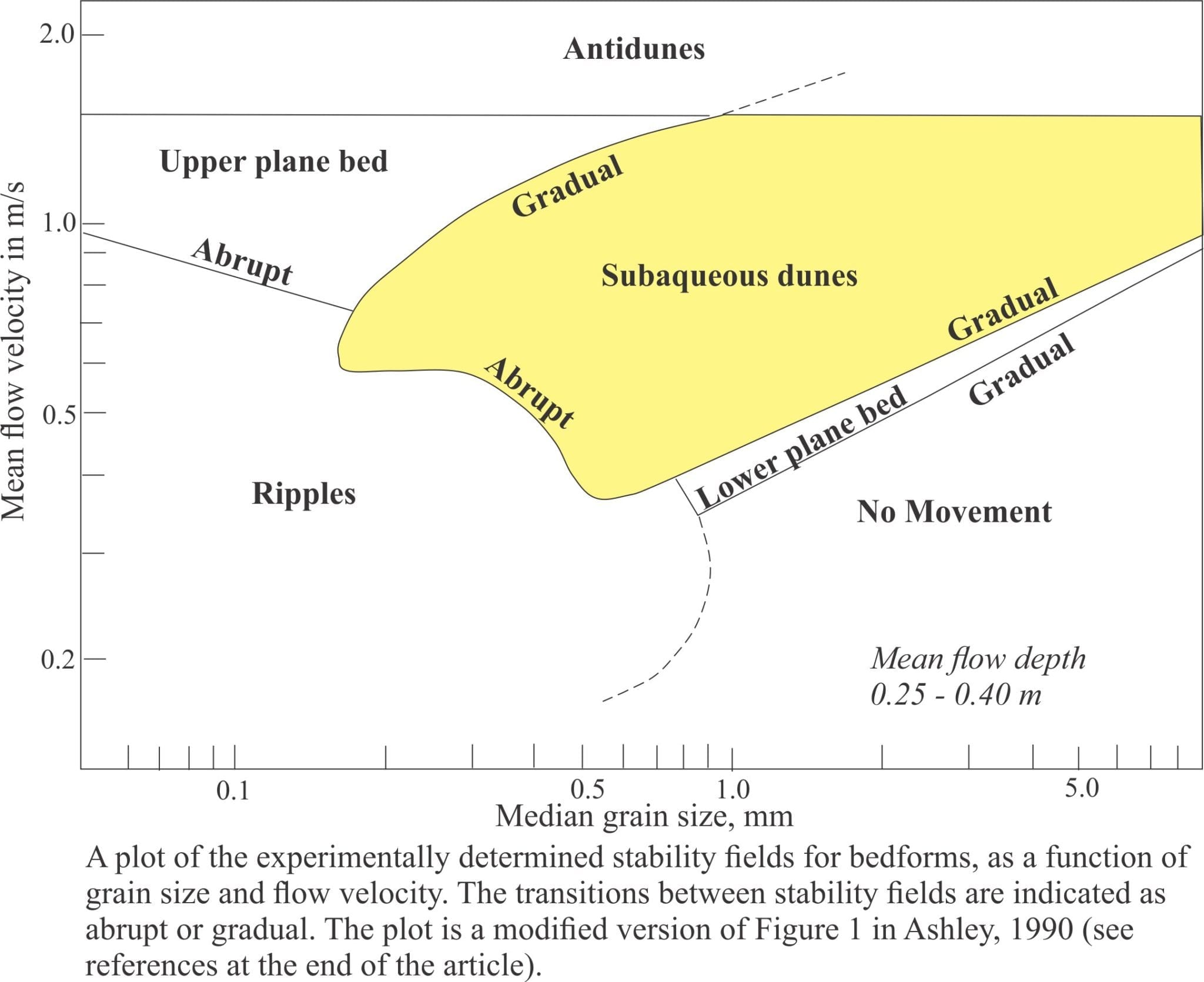
Ripples and dunes form under a relatively limited range of flow conditions. We can illustrate this in a graph of flow velocity against grain size, plotting areas on the graph that correspond to bedform growth. Most of the data for plots like this are derived from flumes where experimental flow conditions can be monitored closely. The plotted distribution shows that bedforms can be categorized according to flow and sediment conditions. This partitioning of bedforms was used to construct the Flow Regime hydraulic model, first published in the now classic 1965 paper by J.C. Harms & R.K. Fahnestock and used widely ever since.

Flow characteristics and beforms in the flow regime hydraulic model, from Harms and Fahnstock, 1965.

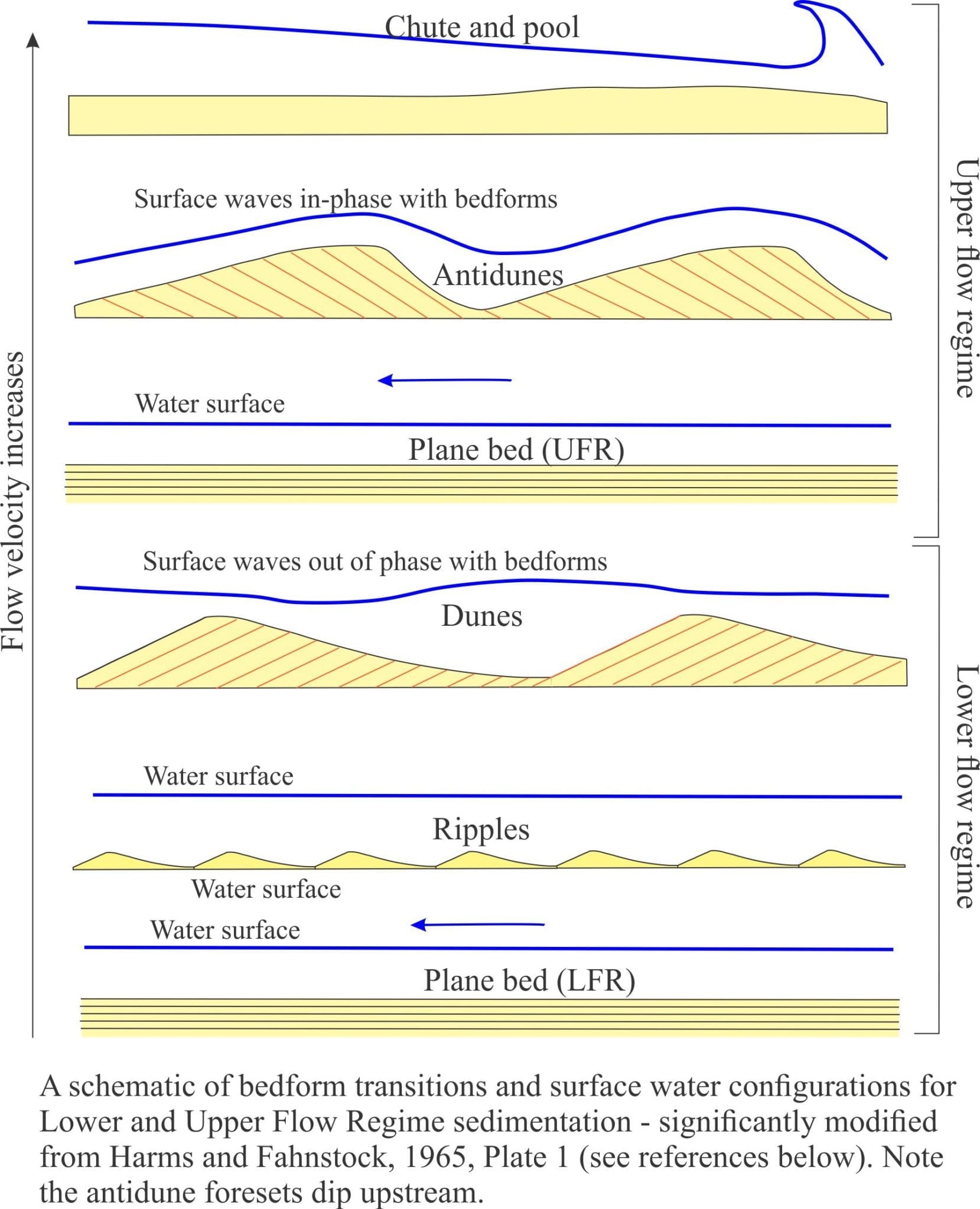
The Flow Regime model considers three fundamentally different states of flow:

  • No bed movement where there is too little energy in the system to initiate and maintain sand grain movement,
  • A Lower Flow regime in which all common bedforms develop. Here, plane bed (basically parallel, planar laminae with no ripples) represents the lowest velocity, or energy conditions where sediment movement is initiated. It has been observed in flumes and in natural channels that the size of bedforms increases from ripples to large subaqueous dunes in concert with flow velocity. Dune type also changes from two dimensional structures (straight crests and planar crossbed bounding surfaces), to three dimensional structures that have sinuous, arcuate and lunate outlines and spoon or scour-shaped bounding surfaces (commonly seen as trough crossbeds).
  • An Upper Flow Regime where the power of stream flow washes out ripples and dunes, replacing them with plane bed (this kind of plane bed commonly has parting lineations), plus antidunes, and erosional chutes and pools.
  • As stream flow increases the transition from Lower to Upper flow regime produces one of the more interesting bedforms – antidunes. They are mostly found in shallow channels (e.g. fluvial and tidal channels). You can recognize that this transition has taken place when you see standing surface waves – watch closely and you will see the waves migrate upstream. Antidunes are the bedforms that develop immediately below standing waves (the two are in-phase). If high flow is maintained, the antidunes will also migrate upstream. However, once flow slackens they tend to wash out; the preservation potential of antidunes is low.


Standing waves in a tidal channel.

The example above shows standing waves in a tidal channel on an out-going tide. Tidal flow is to the left; standing wave migration is to the right (Mangawhai Heads, North Auckland).

  • Hydraulic jumps: The transition from Lower to Upper flow regime passes with a change in bedform, in particular washing out of subaqueous dunes, but there is no sudden break in surface flow – the transition is reasonably smooth. This is not the case for an Upper to Lower flow regime transition that is marked by an abrupt increase in water level and turbulence – a hydraulic jump. Hydraulic jumps can be thought of as standing waves. They are caused by a reduction in Upper Flow Regime velocity, a change in stream-bed gradient or water depth, or combinations of all three.

A kitchen sink demonstration of a hydraulic jump

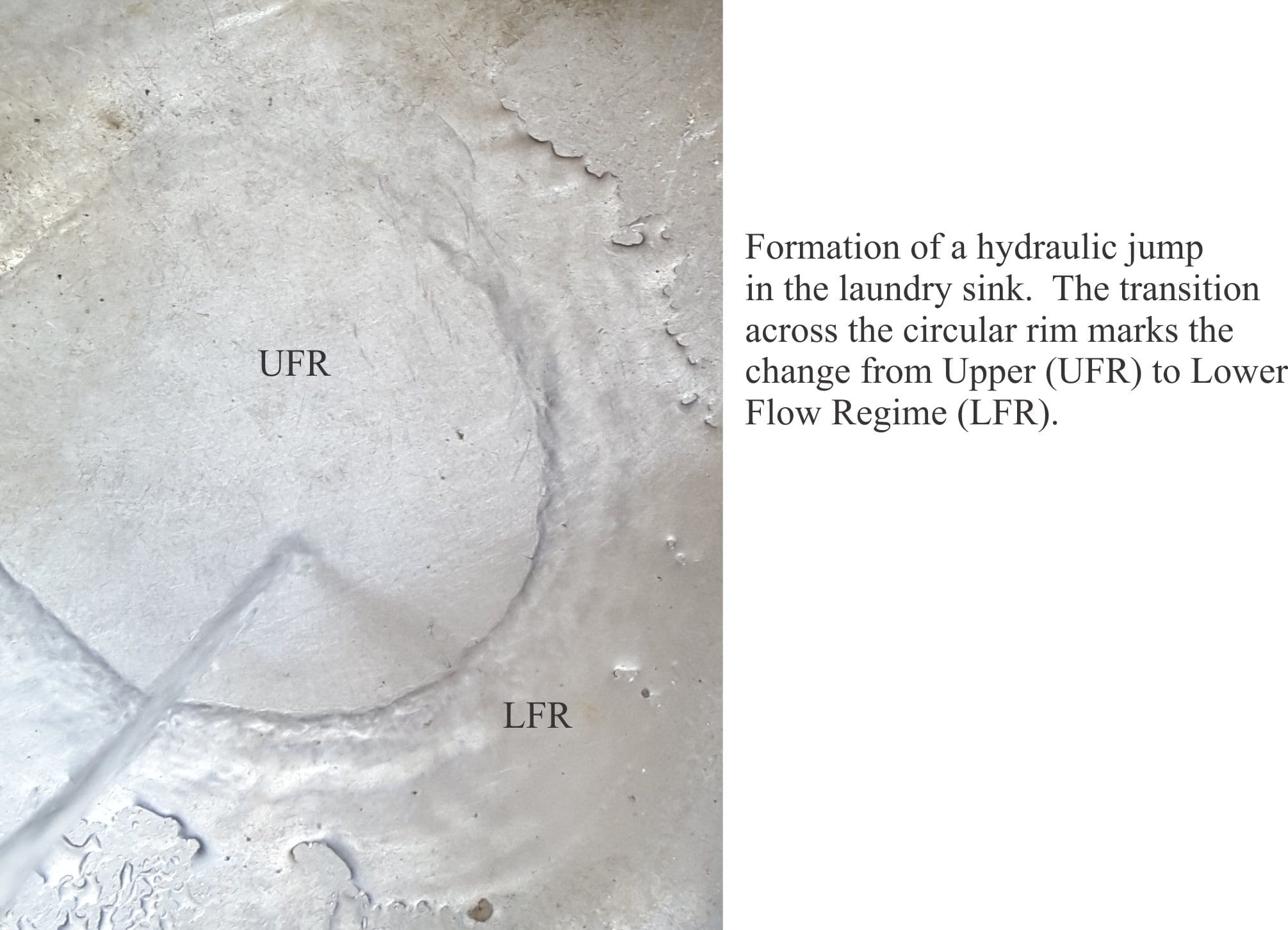
You can generate a hydraulic jump in your kitchen or laundry sink, so long as the sink floor is reasonably flat. Turn on the tap until you see a flow pattern like the one in the image above. Flat laminar flow is generated by the downward force of tap water – this is the plane bed. The hydraulic jump is located where the flow changes abruptly, with an increase in surface amplitude. Beyond the jump is lower flow regime flow.

We can use the Flow Regime concept in the field as a quantitative indicator of changes in paleoflow in time (i.e stratigraphically) and space (laterally).  For example, a stratigraphic sequence that shows a layer of ripples overlain by a layer of trough crossbeds indicates that flow velocities, and hence stream power increased abruptly. What kind of paleoenvironment might this have occurred in? This is one of the central questions for any sedimentological analysis.

Here are a couple of important references:

Ashley, G.M. 1990. Classification of large-scale subaqueous bedforms: A new look at an old problem. Journal of Sedimentary Petrology, v.60, p. 160-172.

Harms, J.C. and Fahnestock, R.K. 1965. Stratification, bed forms, and flow phenomena (with an example from the Rio Grande). S.E.P.M. Special Publication 12, p. 84-115.


Some more useful posts in this series:

Identifying paleocurrent indicators

Measuring and representing paleocurrents

Crossbedding – some common terminology

Sediment transport: Bedload and suspension load

Fluid flow: Froude and Reynolds numbers

Fluid flow: Shields and Hjulström diagrams

Facebooktwitterlinkedininstagram
Facebooktwitterlinkedin

Beach microcosms and river analogues

Facebooktwitterlinkedininstagram

Small streams across a beach - analogues for the larger variety

We are regular visitors to the beach; walks with the kids-grandkids, the dog, swimming, fishing, or just sitting and cogitating. It’s easy to get lost in the timeless rush of waves, their impatient foam. My mind reels at the thought that the sea has been doing this for more than 4 billion years. It’s a bit like getting lost in the night sky. There’s so much to discover.

Beaches are geological domains – part of a continuum that extends to the deep ocean, but a part that is easily accessed.  Geological stuff happens there. My attention is always grabbed by the small streams that drain across beaches at low tide. Whenever we came across one of these my kids would scatter, lest they be regaled yet again about the fascination of miniature worlds. I admit it was a bit over the top, so it goes…

Some beach outflows come and go with the tides, others are more permanent leakage from inland drainage. Some trickle, others rush. They are all fascinating, as microcosms of grander floodplain or massive deltas. Project this microcosm to the real world of geological process, of cause and effect. In doing this, you are engaging in the scientific process of creating your own analogy, an insight into a larger universe.

The streams usually start afresh with each tidal cycle. As tides recede, stream flow begins to erode its channel, deepest at the top of the beach. The channels may be straight and narrow, or broad networks of braided sand. Continue reading

Facebooktwitterlinkedininstagram
Facebooktwitterlinkedin

Crossing the harbour bar

Facebooktwitterlinkedininstagram

Landsat image of Raglan Harbour

A safe harbour offers a place of refuge. Those in peril (or evading taxes), running before a storm, crossing a figurative bar to welcome respite. Non-figurative harbours, the coastal kind, have traditionally provided safe haven for mariners escaping inclement weather or foes.

Harbours fill and are emptied of seawater on the tide. Sea water that enters or exits is commonly focussed through narrow inlets. Here, powerful currents are generated that carry fish, sediment, flotsam, and unwary boats. Filling on an incoming tide is like a cleansing, a renewal; outgoing tides reveal channel arteries that keep alive the bars and broad flats of mud and sand, textured Kandinsky-like.

Northern New Zealand’s west coast has 6 harbours distributed along a 300 km stretch of coast. Each is protected by large sand barriers that have built over the last 2-3 million years with sand moved inshore by successive rises and falls of sea level.

Many of New Zealand’s harbours are drowned valleys, where rising sea level (following the last glaciation) has inundated dissected landscapes. Rising seas have crept up valleys, leaving the exposed high ground to front an intricately embayed coastline, islands, and estuaries that extend their marine fingers far inland.

New Zealand’s west coast is open to large swells, generated by westerly winds across a 2000 km expanse of Tasman Sea. Sea conditions along this coast are often rough. Access to the open sea via harbour inlets, requires sailors to ‘cross the bar’ – the zone of shallow, constantly moving sand. Strong tidal currents, particularly out-going tides can increase wave heights even further, as well as making wave conditions in general very choppy. The sea condition can change rapidly. Many a boat has come to grief across these west coast bars, a mix of bad luck and poor judgement (NIWA has real-time images of current bar conditions at several locations).

The oceanographic and geological term for sand bars at the entrance to harbours and lagoons is tidal delta. Tidal deltas can form on the seaward margin, in which case they are called ebb tidal deltas (because they are downstream of the outgoing tide). Those that form inside harbours and lagoons are flood tidal deltas where sand is deposited by incoming tides.

Raglan Harbour is small but it sports a very nice example of a symmetrical ebb tidal delta. The delta extends 1.5 – 2 km from the harbour mouth. Darker hues (image below) that mark the main channel contrast nicely the shallower sand bars on either side over which waves tend to break. These marginal sand deposits are called swash bars.

Raglan ebb tidal delta outlined by the surf zone

Westerly swells approach the coast with relatively straight crests. As they pass over the shallow delta platform, they move at a slower speed because they interact (friction) with the sea floor. Some of the wave energy is transferred to the sea floor such that sediment is moved as ripples and dunes. Slowing waves also build in amplitude (height); this is the region where waves break. However, the same waves in the adjacent, deeper water are moving at a faster pace – trace the crests of each wave and you will see it ‘bending’ around the delta.

Most of the tidal delta remains submerged even at low tide. Parts of the swash bar that are exposed during low tide show evidence for sand movement, mostly as ripples, large and small. Sand is moved during flood and ebb tides. The shape of these sand bars changes from one tide to the next, demonstrating that this is a dynamic environment.


Exposed margin of the tidal delta platform, with large and small ripple

The Raglan tidal delta consists almost entirely of sand. In contrast, Raglan Harbour and its estuaries contain a high proportion of mud. So where does all that sand come from?

The tidal delta is part of a much larger system of sand transfer – supply and demand from the adjacent continental shelf to the adjacent beaches, shallow sand bars (commonly formed by rip currents) and sand dunes. Sand in the inshore region is also moved along the coast by long-shore currents and it is this sand that continually feeds the delta. The delta in turn, via its main channel, moves sand back onto the shelf, completing the cycle.

The beach south of the tidal delta continually changes its profile. At times the profile is an uninterrupted swath of black sand along most of its length (about 3 km). At other times a significant volume of sand has been removed exposing ancient boulder deposits from nearby Karioi volcano; sand removal frequently occurs during stormy weather. The sand dunes also participate in this budgeting exercise. Sand transfer from the beach (and dunes) is probably a combination of movement directly offshore by rip currents and wave undertow, and long-shore movement towards the delta. Sand replenishment and removal from the beach, and addition to the tidal delta, is part of a much larger system of sand supply and demand – nature’s sand budget.


Pliocene lahars and boulder beach deposits at Raglan, NZ

Sand moved onto the swash bars helps to replace sand that is removed by the deep, fast-moving channel. Channel flows in narrow inlets like the one at Raglan are commonly 4-6 km/hr (1-2 m/second), which may not sound fast (try swimming against it) but is sufficient to move large volumes of sediment during each tidal cycle. There are some small sand bars in the harbour itself, but the channel is an effective flushing mechanism that prevents the estuaries and tidal flats from clogging up.

Changes in sea level have a profound impact on coastal sand systems. If sea level falls, the beach and dunes would follow the retreating shoreline, the harbour would eventually become the domain of non-tidal rivers and swamps, and the main channel would be free to meander over a broad expanse of exposed continental shelf. Tidal deltas might be more ephemeral structures, constantly on the move. This was probably the scenario during the last glaciation, when sea level was more than 100m below its present position.

Perhaps of more immediate concern is a rise in sea level (the present situation) which would erode older foreshore beach and dune deposits, and destabilise some cliff areas south of the Harbour. The Surf Club at the south end of Ngarunui Beach would need to move – yet again. The Harbour area flooded at high tide would increase, resulting in a greater volume of seawater entering and exiting the narrow inlet. To accommodate this, the inlet would need to expand, or the speed of current flow would need to increase. Changes such as these would have an immediate effect on the size and shape of the tidal delta.

Facebooktwitterlinkedininstagram
Facebooktwitterlinkedin

The Ancient Earth 7. The Art of the Stromatolite

Facebooktwitterlinkedininstagram

Algae, Fossil Slime and Organic Precambrian Art

Stromatolites are the earliest physical life forms on earth; they were the precursors to pretty well everything you see living today. There may be indications of earlier life forms preserved as chemical signatures, but as fossils go, something you can see and touch, stromatolites are it. The oldest stromatolites known are from Western Australia – about 3400 million years old. These ancient structures were built by primitive algae and bacteria, aka cyanobacteria, sometimes referred to as blue-green algae. Clearly life had already evolved to something quite complex by 3400 million years ago.

Continue reading

Facebooktwitterlinkedininstagram
Facebooktwitterlinkedin

How do we know which way is up? #2 Ruffles and desiccation

Facebooktwitterlinkedininstagram

How Geologists Interpret Ancient Environments. 2 Ruffles and desiccation

Nearly all sedimentary rocks contain structures – fabrics, planes, contortions. If properly identified these sedimentary structures provide important clues to how the original sediments were deposited.

There are many different kinds of sedimentary structures formed by layers of sediment oriented at different angles, or layers that have been contorted and squished, structures formed by wetting and drying of sediment, structures formed by slip and slide, and by animals leaving tracks and traces as evidence of their activity.

All of these structures can be thought of as contributing to the architecture of sediments and sedimentary rocks.

We are going to examine two of the more common kinds of sedimentary structure – Ripples, and Mud Cracks (sometimes called Desiccation Cracks).

Continue reading

Facebooktwitterlinkedininstagram
Facebooktwitterlinkedin

How do we know which way is up? #1. Getting started

Facebooktwitterlinkedininstagram

How Geologists Interpret Ancient Environments. 1 Getting started

You are confronted with rock formations that might look something like this…

Folded sandstone exposed on a ridge - great place to examine the rocks

The local geologist tells you that the rocks you see here originally were deposited as sands and muds in shallow seas, where beaches and broad coastal tidal flats passed seawards to deeper waters, and landwards to marshes and scrubby coastal plains across which rivers and streams coursed. How did our geologist figure this out? What is it that geologists see in the rocks that help them paint this picture of an idyllic world that existed so many millions of years ago – a world beyond memory, where, in a different eon, a summer cottage would have been rather nice. Continue reading

Facebooktwitterlinkedininstagram
Facebooktwitterlinkedin