We are told that a tide waits for no one, the impatient cousin of time. In its early 13th century idiom (the oldest known quotation is 1225 AD) the word ‘tide’ was associated with time, as in a season, or an instant. Somehow this has morphed in modern English to mean the daily rise and fall of sea level, although the association with time and periodicity remains; the regular advance and retreat of the water’s edge. In modern usage, the word ‘tide’ also connotes an association with the Moon and Sun. Tides, as we now understand them, have helped shape our world for the last 4.6 billion years: kept the oceans honest, tidied up our coastlines, and defined the character of harbours and estuaries. Ships enter and leave on the tide, recycled from one coastal haven to the next.
Ocean tides are the natural response to the forces of gravity acting on earth, its moon, and the sun. Tidal forces act on other planets and their moons. The sulphurous moon Io develops a distinct bulge during its close approach to Jupiter. It is hypothesized that moons Enceladus (Saturn) and Europa (Jupiter), maintain liquid water oceans beneath their frozen surfaces because of the heat generated by the forces of gravity.
Earth tides cycle through highs and lows depending on the relative positions of the moon and sun. Tidal highs and lows also vary from place to place, for example a high tide on the west coast of New Zealand may occur at the same time as a low tide on its east coast. To explain this phenomenon, we first assume a simple model where earth is covered completely by ocean – once we have established an explanation using this simplification, we can add the continents to create a more complicated, real world explanation of tides.
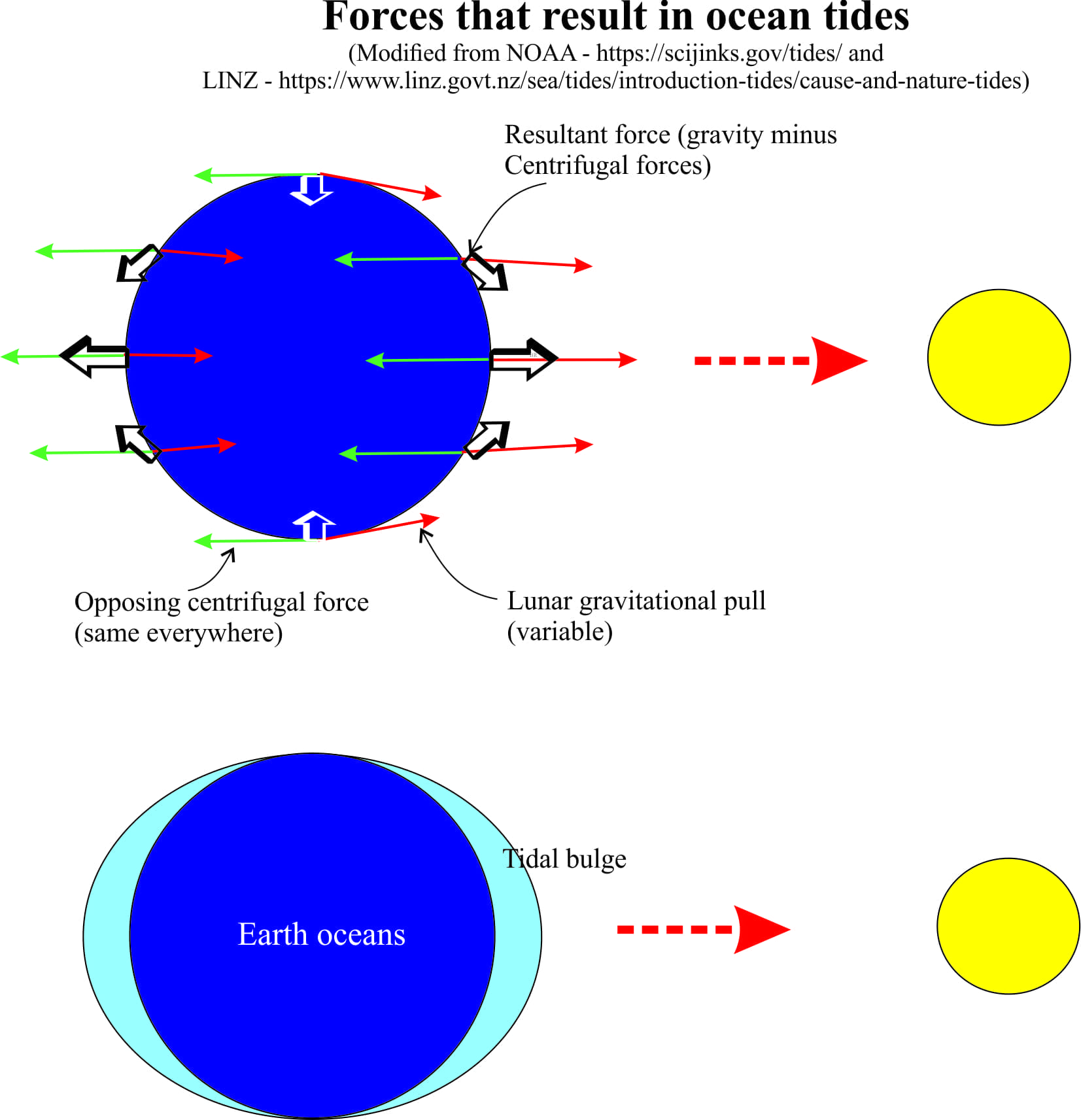
The Earth and Moon are in a state of balance; the Moon exerts a gravitational pull on Earth (and vice versa), and because the Moon orbits Earth (the orbit is slightly elliptical), there is an opposing force – the centrifugal force. As a crude analogy, imagine riding a fast-moving ferris wheel; you are moving in a circle. If you release the safety harness, you will fly off at an angle, propelled from the safety of your seat by a strong centrifugal force. In our celestial system, these two opposing forces keep the Moon from crashing into Earth (and likewise, Earth into the Sun). Centrifugal forces are the same everywhere on Earth, but the Moon’s gravitational pull changes with distance; it is strongest on the side closest to the Moon, and weakest on the opposite side. Thus, at different points on the Earth surface, there is a slight difference between the two forces. The difference is not enough to upset the overall balance between Earth and Moon, but it is strong enough to create a bulge in the ocean mass; one on the side facing the Moon, the other on the opposite side of Earth. The bulges correspond to high tides. However, Earth rotates on its axis, which means that different parts of Earth experience the bulge at different times – note the bulge itself is always aligned with the moon. In this simple model, the bulges on opposite sides of the earth mean that there are two tides every 24 hours, 12 hours apart. These are semidiurnal tides.
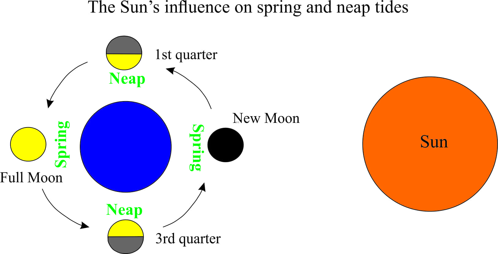
The Sun exerts a similar effect on Earth, but its influence on tides is about half that of the Moon. Nevertheless, the Sun’s gravitational force will reinforce that of the Moon during full and new phases of the Moon, resulting in spring tides; the opposite effect, neap tides occur when the two gravitational forces oppose each other. Other tweaks to this relatively simple celestial model are the elliptical Earth-Moon-Sun orbits (which results in some changes to the gravitational effects), and the tilt of Earth’s own axis of rotation – hence the monthly lunar cycles, and seasonal solar-Earth cycles. Centuries of sky gazing have taught us that all these cycles are predictable which means we can foretell tides well into the future.
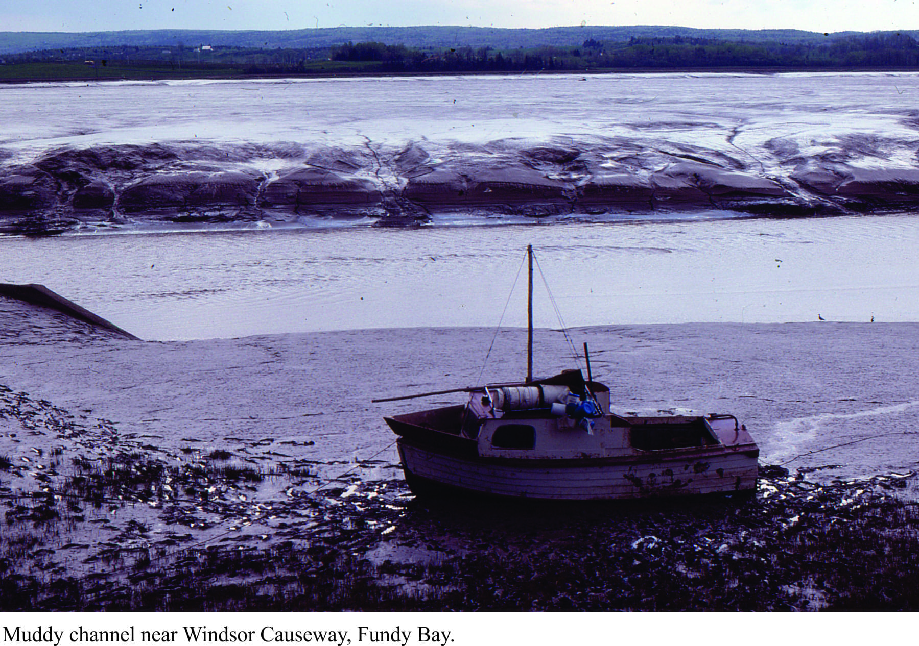
To better understand tides in the real world we now need to complicate our model by adding continents. These massive landmasses have created a degree of ocean isolation (Pacific, Atlantic, Indian) such that tidal cycles can be considered separately for each ocean. The tidal bulge, or tidal wave, is slowed as it enters shallow coastal waters and is also is deflected, such that it moves, wave-like, around each ocean margin. Tidal waves in the northern Hemisphere move anticlockwise, while those in the south move clockwise. Thus, high and low tides will also migrate along ocean coasts. These patterns apply to the oceans as a whole, but on a more local scale, the tidal wave can be deflected, amplified, or weakened, depending on the shape of the coastline and variations in water depth. A classic example of tidal amplification is Fundy Bay, a narrow stretch of water between New Brunswick and Nova Scotia (eastern Canada). Here tidal ranges of 17m are common, in marked contrast to those on the opposite coast (e.g. 2m tides in Halifax). Tides here flood very quickly, initially as a tidal bore that in places may be a 2-4m high wall of water (check out this link to a short video, taken near Moncton, New Brunswick).
The simple Earth ocean model predicts two tides every 24 hours, or semidiurnal tides. Adding continents, coastlines and varying water depths further complicates this picture such that in places only one tide occurs each day; these are diurnal tides (e.g. Gulf of Mexico, the Kamchatka coast), or mixed semidiurnal tides where one high tide is significantly higher than the other (i.e. one high tide is weakened).
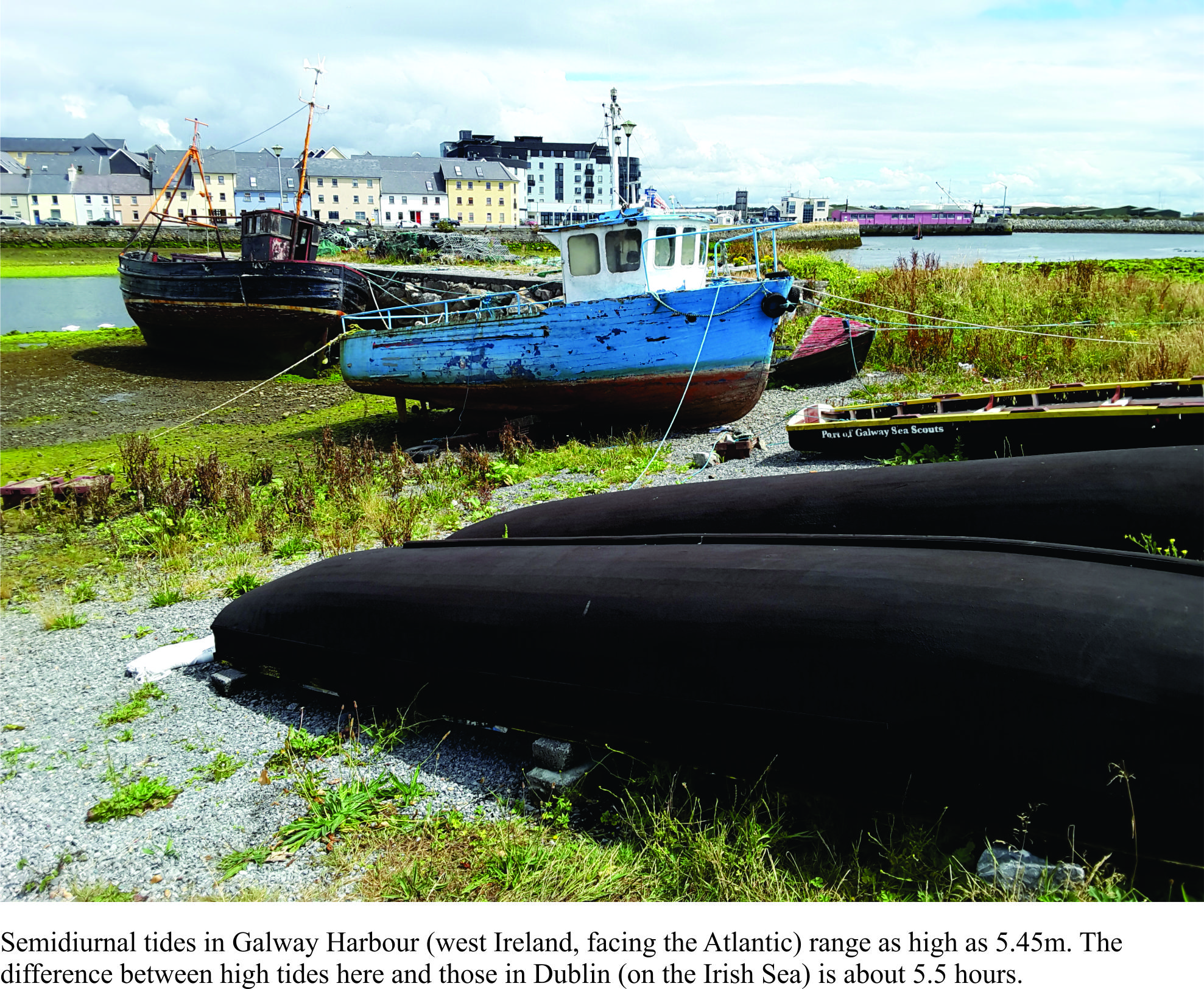
Along the New Zealand coast, both lunar and solar tidal waves move anticlockwise (the opposite direction to much of the southern hemisphere). Tidal ranges are highest on the west coast, where both tidal waves reinforce the tidal signal, and are lower on the east coast where the solar tidal wave is weakened. The National Institute of Water and Atmosphere (NIWA) has produced animations of the lunar and solar tidal waves. High tide in the far north of New Zealand is about 6 hours ahead (or behind) that in the far south. It takes 12-13 hours for the tidal wave to traverse around the entire New Zealand coast, which means that a high tide at any location, will have a corresponding low tide somewhere else. This difference is nicely illustrated in Auckland city which lies between two harbours; Auckland Harbour on its eastern coast (Hauraki Gulf – Pacific Ocean) is geographically separated from Manukau Harbour on the west side (connected to Tasman Sea), by an isthmus that in places is barely 1000m wide. It takes about 3.5 hours for the tidal wave to travel north up the east coast, and south down the west coast to Manukau Harbour.
Tidal range, the elevation difference between high and low tides, is also affected by weather. High pressure weather systems tend to lower sea level, whereas low pressure systems result in higher than normal sea levels. Coastal regions can experience serious problems from flooding, when a spring tide corresponds with the passage of major storms, particularly cyclones and hurricanes. To make matters worse, storms like these usually generate high rainfall. Elevated tides plus storm surges will cause rivers to back-up, flooding low lying areas.
Tidal ebbs and flows have moved ocean water masses, flushed embayments, moved sediment, and helped shape coastlines ever since Earth acquired a Moon. Tides are periodic; they cycle endlessly through their highs and lows. They are also superimposed on the straight arrow of time (borrowing a phrase from Stephen J. Gould), such that we can now predict the times and ranges of tides well into the future.
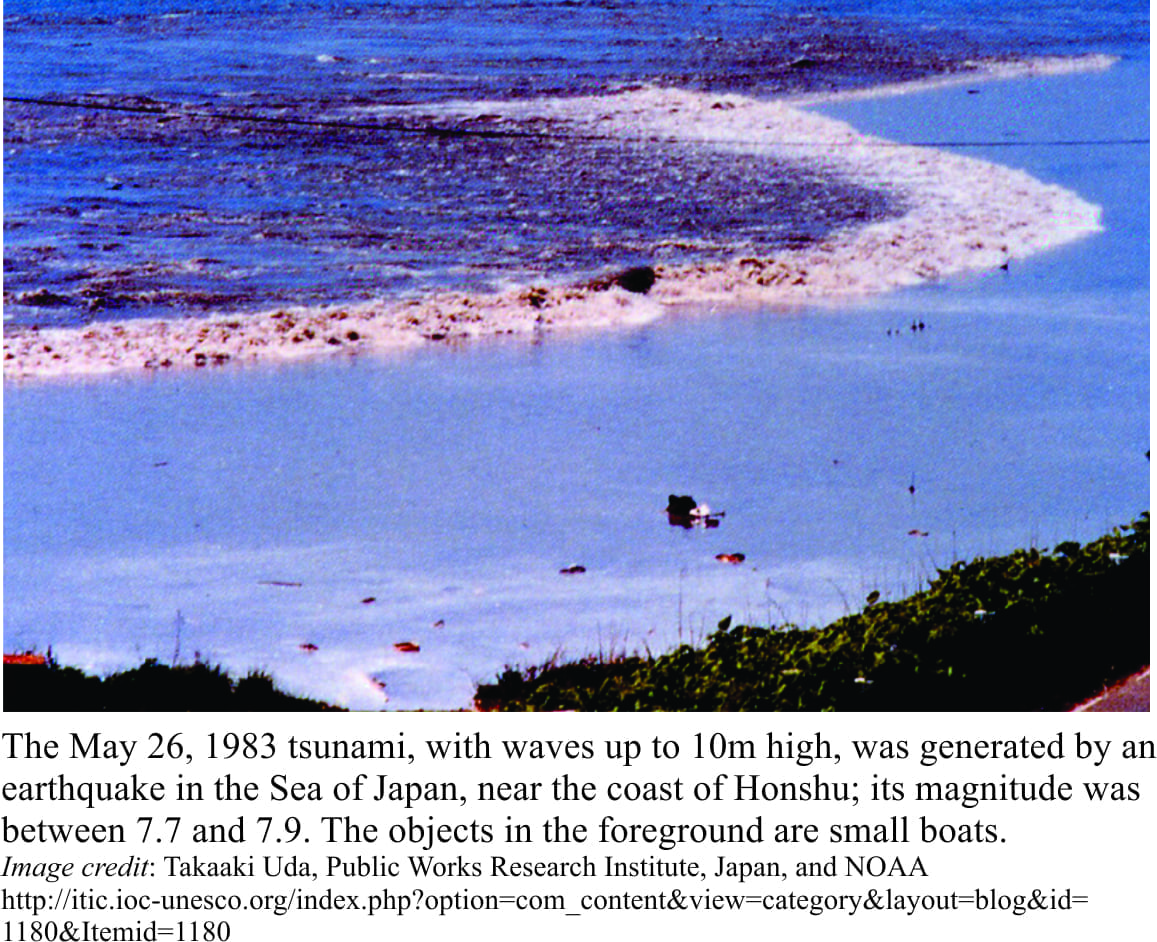
Note: The name tidal wave is sometimes used to describe a tsunami. Tsunamis have no relationship with tides. Tidal wave should only be used to name long period, gravitationally induced waves.