Tag Archives: wave run-up

Rip currents – you’ve been warned

Facebooktwitterlinkedininstagram

A rocky mound, 1500m above, and 119.44 km straight-line distance from the sea, is about as far as one can get in New Zealand from either the Tasman and Pacific coasts. The location is in central Otago, southern New Zealand, a region better known for its Pinot Noir. No one lives at this farthest point from the beach.  In fact, most New Zealand folk live only a few kilometres from the sea. Hence the summer exodus. Any nostalgia for those snow-bound, icicled, northern hemisphere winter solstice festivities is short-lived, banished by squealing kids and crying gulls.

I don’t like putting a damper on this general sense of merriment but, despite all the signs that warn, all the cautions and reminders of potential dangers, people drown. New Zealand has one of the worst records for preventable drownings of any OECD country (113 in 2015).  Most drownings occur at seaside beaches where rip currents are the leading cause of strife for swimmers – there were over 1300 rescues in 2015 (NZ), and most of those were plucked from rip currents.  These statistics are repeated the world over.

As waves approach the shore they begin to interact with the sea floor, growing in amplitude (wave height) until they break. Waves in the surf zone move the water mass onto the beach. Gravity requires that all this water then moves down the beach slope, back to the surf zone. On all beaches, the return flow, or backwash, produces an undertow that flows beneath the incoming waves. Undertow occurs everywhere along a beach. Its influence is generally confined to the surf zone, and for the most part is not dangerous (although it can be quite a strong flow).  Undertow IS NOT the same process as a rip current. Rip currents are not that same as tidal currents.

Rip currents along a Chilean beach

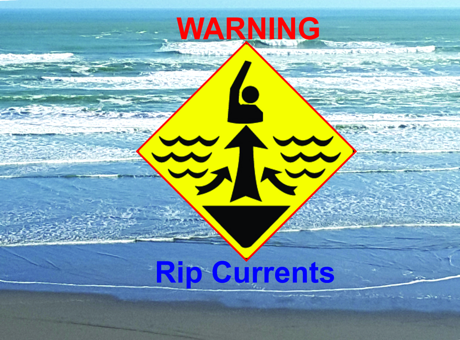
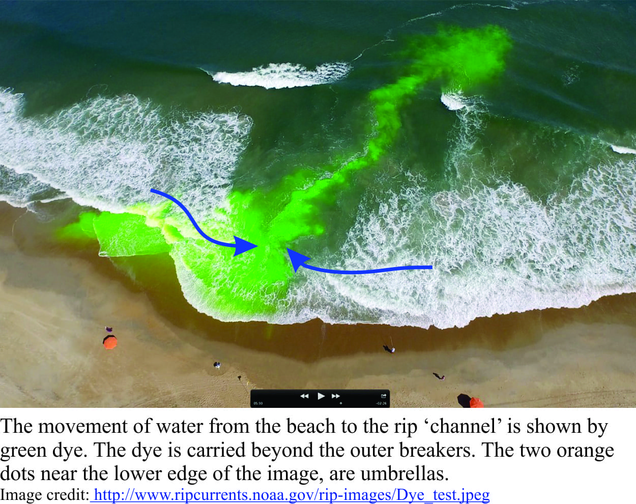
As water moves back into the surf zone, it commonly shifts sideways across the beach, a process referred to as along-shore drift. Most swimmers will have experienced this ‘drift’ when they find themselves farther along the beach from where they started (this is usually where the local surf lifeguard starts waving at you to return to the flagged swimming area). Rip currents form when the returning seawater is diverted and focused by shallow holes and sand bars on the sea floor. If the sand bars extend onto the beach, then the waterline will have a kind of point-like shape along the beach (as shown in the images here). These channel-like currents frequently extend beyond the surf zone. Rip currents are narrow flows (a few 10s of metres wide) that move rapidly offshore; current speeds of 4m/second have been recorded, speeds that are well beyond the ability of even the strongest swimmer. The currents are powerful because so much water is being focused through a relatively narrow gap. Rips can appear suddenly on any beach where there is appreciable wave activity. They can also form adjacent to rocky promontories.

An experiment with green dye showing the path of rip current flow

Rip currents are best viewed from an elevated vantage; they are not easily seen from the water’s edge. Useful identifying features include:

  • The surface waters of a rip tend to be relatively calm or rippled,
  • The current cuts through the surf and is usually clear of large breaking waves,
  • Currents commonly carry flotsam (including swimmers) or sediment offshore, and hence may appear cloudy, and
  • A point-like, or cuspate shape to the waterline along the beach may indicated submerged sand bars – such features increase the likelihood that rip currents will form.

While swimmers and life guards tend to view rip currents with (respectful) dislike, people who study coastal processes see them as one process among many, that shape coastlines. On sandy coasts, sediment is constantly being transferred among the deeper offshore regions of the sea bed, the shore and beach, and sand dunes.  Sometimes the beach or dunes are in sand deficit, and at other times in surplus.  Breaking waves tend to move sand onshore, whereas undertow and rip currents tend to move sand seaward. There is generally a balance between the onshore and offshore transfer of sand, but this can be disrupted by seasonal changes in tidal currents and storm tracks, by decadal cycles in the movement of ocean water masses, and by longer-term rises or falls in sea-level.  Rip currents, despite the risks they pose, are an important part of coastal sand budgeting and transfer .  They are a geological phenomenon.

The advice normally given to anyone caught in a rip is DON’T PANIC (perhaps more easily said than done), and don’t try to swim against the current – you will not win that contest. Swim parallel to the beach and you will eventually exit the current. Surf life-saving folk put up flags where they assess the safest stretch of beach to be. It is common for these flags to be moved up or down the beach, as rips come and go.  But these common-sense warnings are ignored by too many – if they’re lucky they won’t enter the books as another statistic.

Surf Life Saving Australia has produced this useful video

Facebooktwitterlinkedininstagram
Facebooktwitterlinkedin

When nature casually flicks a finger at us

Facebooktwitterlinkedininstagram

Trim line of forest devastation from the Lituya Bat tsunami

I always feel a sense of unease when hearing of natural disasters.  I live in a country where earthquakes, volcanic eruptions, landslides, floods and the threat of tsunamis all occur within a relatively small land area.  In Canada, I lived on a small island (a daily ferry commute), nestled in a typical West coast fiord near Vancouver and more than once I pondered the possibility, even inevitability of those towering rock walls suddenly obeying the laws of gravity.

Fiords exist because of ponderous gouging and plucking of the solid earth by rivers of ice; testaments to ancient glacial climates and the forces of nature.  Fiord landscapes are stunning, beautiful in and of themselves and, I suspect because they invoke a sense of awe.  But this is a façade.  Rock walls, almost vertical in places and towering 100s if not 1000s of metres are inherently unstable; any glaciers at the head of the fiord or hanging off the valley walls exacerbate the problems.  Landslides, rockfalls and glacier calving inevitably end up in the sea and the resulting tsunamis can be terrifying.  The video here shows these guys had a lucky escape after venturing a bit too close to a calving, Greenland glacier.


All that energy focused through a narrow gap

Terrestrial or submarine landslides that occur on open coasts can produce locally massive tsunami waves (10s of metres high) but these tend to dissipate radially.  There are well known examples on oceanic volcanoes like Canary Islands and Hawaii.  From the North Sea, the Storegga submarine landslide about 8000 years ago must have devastated parts of Britain and northern Europe coasts with wave run-up locally 20m and more. The Youtube Video here shows a recreation of this event.

Tsunamis generated in fiords react differently because the wave energy is focused, generally along the length of the fiord.  Some of the largest waves on record, either observed directly or the immediate aftermath, have been generated in fiords.  There are many examples – historical and prehistoric.  The three I have chosen are well documented and pretty spectacular.  They provide a sober reminder of what can happen when nature casually flicks a finger at us.


Talfjord, Norway, 1934

On April 7, about 2 million cubic metres of rock fell about 700m into the fiord.  Displacement of water instantly created a wave that initially was 62m high near the landslide impact.  By the time the wave had reached the village of Talfjord some 5 km away it was still 16m. It was about 3am and most in the town were asleep.   Geological mapping has shown that there have been at least 10 landslides along a 7km stretch of the fiord, and along the adjacent Storfjorden 108 rockslides have been identified, all occurring since deglaciation about 14,500 years ago (Source: Harbitz et al. 2014, Coastal Engineering, v 88).  It was common knowledge at the time that the rock mass above the fiord was unstable, where tension cracks were forming.  Unfortunately, there are no real geotechnical solutions to a problem like this, other than monitoring.

A similarly unstable, but much larger rock mass in Storfjorden (about 50 million m3) has been monitored for several years.  Signs of instability include tension gashes that seem to become larger every year.  Early warning systems are in place although the warning time for the closest villages is likely to be no more than a few minutes.  Fingers are crossed.

Paatuut, Greenland, November 21, 2000

A large landslide at Paatuut located in a fiord on Greenland’s west coast, moved about 90 million m3 of rocky debris about a third of which splashed into the fiord.  The landslide was initiated 1000-1400m above sea level.  No one witnessed the landslide but the resulting tsunami was recorded in a small village about 40km away.  On the side of the fiord opposite Paatuut an abandoned mining town (Qullissat) about 25km away was almost destroyed.  Wave run-up at Qullissat was 28m (observed in the lines of debris) and it is estimated that the wave near the landslide itself had a run-up of about 50m.  Seven kilometres northwest of Paatuut several icebergs were left stranded up to 700m from the coast on an alluvial fan.  Fishing crates and other flotsam were stranded to 800m inland and 40m above sea level.


Lituya Bay, Alaska, July 9, 1958

Aerial view (1960) of the trim-line Lituya Bay

One of the largest waves ever observed (and survived) took place in Lituya Bay, Alaska during a 1958 magnitude 7.8 earthquake along the Fairweather Fault (Fairweather Fault is part of an extensive system of active faults that mark the boundary between the Pacific and North American plates – it is a fundamental structure in the Alaskan Panhandle.).

The tsunami was triggered by a 30 million m3 rock mass falling more than 900m into Gilbert Inlet at the head of Lituya Bay.  It seems likely that collapse of the glacier front at the head of the Bay also played a role in generating massive waves. The wave nearest the landslide had an incredible 524m run-up (1720 feet), but subsided to about 10m near the entrance to the open sea.  Wave run-up was easily mapped along Lituya Bay by the line of devastated forest; also known as trim lines.

Howard Urlich and his 7 year-old son, from their fishing boat anchored in a sheltered bay, provided first-hand accounts of what must have been a terrifying experience.  They awoke to a wall of water, that from their estimates was 50-75 feet high (15-22m) coming at them.  The boat was anchored in about 10m of water.  Unable to release the anchor Urlich let the anchor chain run free – it snapped at about 40 fathoms (73m – note however that the boat would have been carried forward at this point in their adventure and the 73m does not indicate true wave height; but it does give some indication).  The boat was carried along the front of the wave over the adjacent shore and several metres above the trees. It was then washed back into the bay, still upright.  A couple of other boats in the bay didn’t fare so well.  The Youtube video shows a dramatic reconstruction of events.

Trimline 55 m above sea level; below, evidence for the force of the wave

Read the first USGS account by Don Miller, 1960 here,  and some old images here.

The list of terrifyingly spectacular fiord tsunamis goes on.  For example, a more recent event at Taan Fiord Alaska, October 17, 2015 – as if Lituya Bay wasn’t enough; this one is still under investigation, but it looks like the wave was capable of hedge-trimming activities to about 150m and tossing boulders even higher.


Postscript

The day I wrote this post ended with a magnitude 7.5 jolt in northeast South Island, New Zealand (north of Christchurch).  We live about 800 km north of the Kaikoura epicentre and our house shook and swayed, trees swayed, and water in the pool sloshed over the sides.  No damage to us, but considerable building and infrastructure damage farther south. Some aftershocks have been greater than magnitude 6. A rude awakening…

Facebooktwitterlinkedininstagram
Facebooktwitterlinkedin