
Earth’s magnetic field is on the move – so too is magnetic North!
Constancy in life is a comforting, if not fleeting thought, shattered by riddles, unknowns, and sometimes brutal realities. Even the supposed constant that your compass always points north has an unsettling caveat; sometimes it may point south.
What is North? True North, or geographic north, is a point that we have defined by constructing lines of Longitude that converge at the north and south geographic poles. Geographic poles are close to the pole of earth’s rotation, but a Chandler Wobble in the rotation axis means that this pole moves a bit. The Celestial Poles, a heavenly figment, are defined by an imaginary line drawn along the axis of rotation to the Pole Star, Polaris. Because Polaris is very close to this axis, it appears to be stationary in the night sky, whereas all other stars appear to move from east to west. However, even this pole moves, albeit pretty slowly with precession of the equinoxes, completing a complete cycle about every 25,000 years. And then there is magnetic north.
Magnetic North
Most of Earth’s magnetic field is generated by a hot (4000-5000oC), fluid-like, iron-nickel rich outer core that moves slowly around a solid iron inner core. The shape of the magnetic field is approximated in a simple experiment using a bar magnet and iron filings. The magnetic field is vertical at the poles and horizontal at the equator.
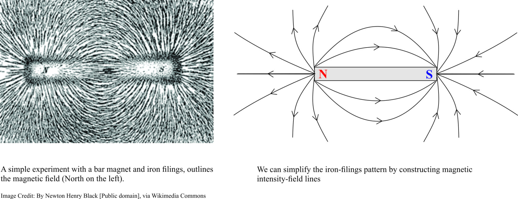
The bar magnet model is a useful simplification in that it allows us to visualize the magnetic field. Earth’s magnetic field is much more complicated because it interacts with solar wind; we see this interaction in spectacular aurora (Borealis in the north, Australis in the south).

We can be thankful this interaction takes place – our magnetic field helps protect us from harmful cosmic rays and from interference with electrical and communications systems (especially during solar storms). It also protects our atmosphere from being stripped and lost to space; Mars has a much weaker magnetic field and has lost most of its early, denser atmosphere (there is a lot of evidence to indicate that the surface of Mars was partly shaped by water. Most of the water has disappeared).
The impact of solar winds results in a tear-drop shaped magnetic field, with the head of the ‘drop’ towards the sun (extending about 65,000 km), tapering over 600,000 km away from earth.
Magnetic North is on the move
Magnetic north pole is currently about 500 km south of the geographic pole, heading towards Siberia. It has moved nearly 1000 km since it was first located in 1831 by James Ross.
Could it flip completely, such that magnetic ‘north’ becomes antipodean?
Early in the 20th Century, Geophysicists and geologists wondered whether the earth’s magnetic field had always been oriented north-south, or if it had flipped or reversed at any time in the geological past. Fertile scientific minds, like Bernard Brunhes and Motonori Matuyama, devised experiments where remnant magnetism was measured in volcanic rocks. The rationale is that when lavas solidify, iron-bearing minerals in the rock, especially basalt, will act like tiny fossil magnets that record
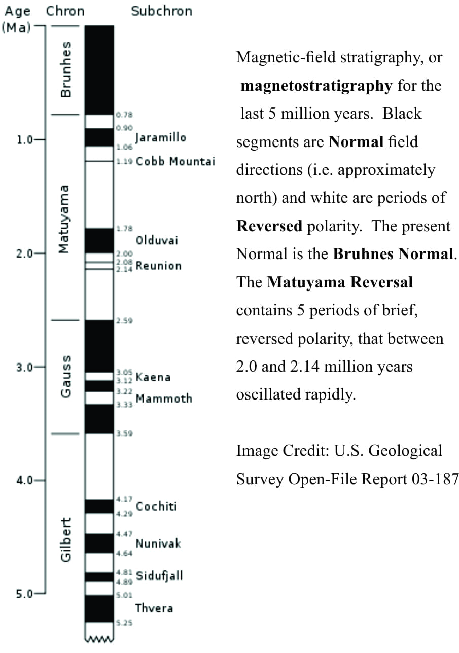 the direction (polarity) of the magnetic field at that time. It was shown that the magnetic field had indeed reversed in the distant past. If the age of the rock being measured is known, then so too is the age of the reversed magnetism. This method can now be extended to other rock types that contain iron-bearing minerals (including sedimentary and other kinds of volcanic rock). It has since been established (using many 1000s of measurements from rocks of all ages) that reversal of our magnetic field has occurred many times, and over the last few million years this has happened about every 200,000 to 300,000 years. The last reversal took place 780,000 years ago; this is called the Brunhes-Matuyama Reversal.
The End is not Nigh!
It seems we are long overdue for a reversal! Hence the scientific interest in some current trends in magnetic field strength and direction:
- The rate of magnetic pole ‘wandering’ seems to be accelerating; present rate of movement is about 50 km/year, and
- The overall field strength has decreased about 15% over the last 200 years.
While dooms-dayers, nay-sayers, and some existentialists will issue stark predictions with this news, we need to remember some basic facts. First, scientists are watching trends in the data; no one is predicting an imminent magnetic field reversal and it is possible the present decrease in field strength is a result of natural variation. Second, earth’s internal machinery will continue to work (i.e. the core) and therefore will continue to generate a magnetic field, and third, reversals have happened 100s of times in the past; there were no changes in fauna or flora during reversals over the last million years or so (although certain species may be affected, these events are not associated with major extinctions). There is also no clear link between glaciations and magnetic reversals.
When a reversal does occur, there will potentially be disruptions to everything associated with electricity and magnetism; navigation, communications, power grids. But forewarned is forearmed. Our own species survived the last reversal; it will survive the next one.
NASA has released a stunning video of aurora from space.
1 thought on “When North becomes South; The flip-side of earth’s magnetic field”
Pingback: Misconceptions and Facts: Lies and Truth About the Business of Modeling