 Please note – I no longer maintain Glossaries by alphabet; A, B, C… etc. All items on these pages have been moved to subject-specific glossaries such as Volcanology, Sedimentary facies and processes, and so on. The list of subject-based glossaries can be viewed in the drop-down menu on the navigation bar. These glossaries are continually updated.

Tabular crossbed: Crossbeds having a planar bottom set (boundary) across which foresets are in tangential or abrupt angular contact. Also called 2D subaqueous dunes.
Talus: Angular, poorly sorted rubble that accumulates at the base of steep rock faces or slopes, typically associated with exposed fault planes. If the source of eroded material is focused, a talus fan may form.
Tear fault: Predominantly strike-slip faults oriented at a high angle to a thrust fault, that accommodate bending and other discontinuities along the thrust, breaking it into compartments.
Tectonic province: Regions of tectonism or lack of it, magmatism, volcanism, and metamorphism in a plate tectonic context. Such provinces include collision orogens, magmatic arcs, forearc and foreland basins, strike-slip basins, oceanic basins, and stable cratons. The concept was popularized by W.R. Dickinson to relate provenance to plate tectonics.
Tectonic subsidence: The component of total subsidence resulting from crustal-lithosphere scale processes such as rifting, the isostatic response to lithosphere cooling and densification (such as passive margins, oceanic crust), and fault-controlled strike slip pull-apart subsidence. It is calculated using the backstripping geohistory method. Tectonic subsidence curves commonly have signatures that are common to a specific subsidence mechanism, for example the synrift and postrift stages of passive margin subsidence.
Tectonic transport: The movement of crustal or lithospheric blocks along major faults or fault zones. It can occur at the scale of a single thrust duplex, and entire fold-thrust belt, and obducted or delaminated segments of the lithosphere
Tektites: Small globules of glass or melted bedrock formed by melting of rock during meteorite impacts. Because of their small size (millimetres) tektites can be flung 100s of km from the impact site.
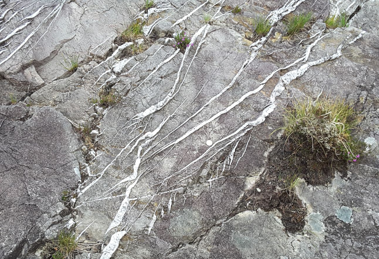
Tension gashes: En echelon fractures formed by brittle failure of hard rock under tension forces, that become filled with crystal precipitates; commonly quartz, calcite, dolomite. The gashes will assume a sigmoidal or sinusoidal shape if there is a component of shear and rotation. The structures are useful indicators of paleo-stress conditions.
Tephra: As originally defined by Thorarinsson (1941), it includes all air-borne volcaniclastics ejected directly by volcanic eruptions. It does not include subaqueous ejecta. Thus, tephra can include the finest ash particles and the largest blocks. Cf. Tuff.
Terrain: A general term for land and landforms. Common qualifications include rough terrain, flat terrain, mountainous terrain, subdued terrain. Cf terrane.
Terrane: Stratigraphic and structurally distinct blocks, ranging in size from lithospheric scale to thin crustal slivers, kilometres to 1000s of km in extent, and in fault contact with neighbouring terranes or autochthonous cratons. All terranes are allochthonous, emplaced by plate tectonic processes, mostly contractional or strike-slip. Many orogens consist of a collage of disparate terranes. See Terrane stitching, terrane docking, overlap assemblage.
Terrane docking: The accretion of an allochthonous terrane to another terrane, stable craton, or orogenic belt. The timing of docking events are a critical part of unraveling the history of an orogen.
Terrane stitching: Intrusive magmatic rocks that crosscut the faulted boundary between two terranes. Dating the intrusives provides an upper age limit for terrane docking.
Terminal moraine: An accumulation of rocky debris at the snout of a glacier (also called an end moraine). The debris is derived from bedrock plucked from the valley walls (lateral moraines) and glacier base and dumped during ice ablation. The moraines mark the maximum advance at any particular time of a glacier’s history.
Terrigenous: A very general term for detrital sediment derived from sources on land. Sediment production is primarily by weathering and erosion. Terrigenous sediment is transported to the sea mainly by rivers. Air-borne dust may also find its way into the marine environment. Most siliciclastic sediment deposited in marine environments is ultimately land-derived. See also provenance.
Textural maturity: Describes the grain size range of granular sediments in terms of its sorting. For example, a well-sorted sand is regarded as texturally mature by virtue of the limited range of grain sizes present. It also implies a degree of hydraulic reworking, where fine-grained sediment has been winnowed. Compare a well-washed beach sand (mature) with a turbidite sandstone where there is virtually no reworking (immature).
Texture: In rock descriptions, texture refers to the physical qualities of detrital clasts and crystals: their size, shape, roundness, surface structures, and fabric. See also grain size distributions, sorting, textural maturity.
Thalweg: In river systems, an imaginary line connecting the deepest parts of a channel along its length is the thalweg, or talweg.
Thermal subsidence: Subsidence of the lithosphere resulting from cooling and densification, following an earlier rifting and heating event. Cooling is exponential over periods commonly exceeding 100 Myrs. Subsidence takes place by lithospheric flexure. Thermal subsidence is usually initiated at the start of sea floor spreading. Passive margin succession provide a stratigraphic record of thermal subsidence.
Thermocline: The ocean layer extending from about 200m to 1000m depth where the temperature decreases rapidly. Below the thermocline the water temperature varies little from about 4o
Thin section: A slice of rock glued to a glass slide and ground to about 30 micron thickness. It is used for petrographic analysis using a polarizing microscope. The rock wafer is either covered by a very thin glass cover slip, or left uncovered to be used with other petrographic analytical methods such as mineral staining. The thickness corresponds to quartz with pale grey interference colours.
Thin-skinned deformation: A reference to crustal-scale deformation, such as fold-thrust belts, that structurally overlie basement rocks that have not been involved in the deformation. The cross-section shown below (Alberta Front Ranges) is a classic example. In that example, the fold-thrust belt is part of the allochthon, and the Paleozoic cratonic strata and crystalline basement are part of the autochthon.
Threshold velocity: In sedimentary hydrodynamics, this is the velocity at which fluid forces overcome gravity and friction forces acting on grains. This boundary condition depends on grain size, density and shape, and on the roughness at the sediment-water interface – that is roughness caused by grains of different sizes.
Thrombolite: Cryptalgal or microbialite structures that have clotted textures rather than the more structured, laminated and branched stromatolites.
Thrust fault: A low-angle reverse fault placing older rocks over younger. Thrust fault systems can carrying thick slabs of crust over large horizontal distances. They are the principal form of deformation in mountain belts formed along contractional plate margins.
Thrust flat: Initiation of thrust displacement begins along a mechanically weak layer, such as a shale; a bedding plane or foliation-parallel fault that has a hanging wall and a foot wall. Thrust flats are usually paired with ramps.
Thrust nappe: A large, regional-scale recumbent fold (commonly kilometre scale), frequently isoclinal, formed during regional compressional tectonism. Shearing along the lower limb is linked with tectonic transport relative to underlying strata. Derived from the French word for cover or sheet.
Thrust ramp: Thrust displacement is transferred from a flat to an inclined fault plane, or ramp that breaks through mechanically strong layers. Ramps commonly, dip at angles or 10 – 30 towards the hinterland; thus, vergence is toward the foreland. Ramps, like most faults, have hanging and foot walls. Cutoffs provide an opportunity to measure the amount of slip. Thrust ramps are usually paired with flats. Displacement is also accommodated by folds in the hanging wall.
Thrust tip – tip line: The point or fault plane edge where displacement ends. Note this does not mean that deformation also stops at these fault plane limits; strain is usually accommodated by folding, and in some cases cleavage.
Thrust vergence: The direction of hanging wall transport relative to the foot wall. In most fold-thrust belts and accretionary wedges vergence is towards the foreland.
Tidal bulge: The bulge in ocean water mass caused by the gravitational pull of the moon, that develops on the side facing the Moon and the immediate opposite side of Earth. The bulge corresponds to high tide. Earth’s rotates through this tidal bulge resulting in the high tide to move along ocean margins; (in other words, the bulge stays in place and Earth moves). See tidal wave, tidal range.
Tidal deltas: Sandy, delta platforms that accumulate at entrance to tidal channels that drain harbours, bays, and lagoons. They are classified as ebb or flood deltas; ebb tidal deltas form on the seaward margin of the channel entrance and can be modified by marine processes. Deposits typically are sand-dominated, and comprise trough crossbedded channel facies, and on the adjacent (submerged) platform ripples and sandwaves.
Tidal flat: Broad, low relief and low gradient expanses, extending from high tide to low tide limits. They are exposed during ebb tides. They are commonly home to a diverse benthic fauna and flora, and are important breeding and feeding grounds for many marine organisms. Sediment is commonly a mix of sand and mud. Mud-prone versions are sometimes called mud-flats. They may be drained by tidal channels.
Tidal gauge: A device for measuring the relative changes in sea level. Measurements are specific to the location of the gauge and in themselves do not account for uplift or subsidence of the land, unless coupled with a GPS instrument or satellite altimetry. Corrections need to be made for the kind of coast (open sea or sheltered harbour), air pressure, water temperature, storm surges, and tectonic-seismic events. The measuring device can be as simple as a graduated post, or sophisticated satellite radar altimetry.
Tidal range: This is the range between mean high water and mean low water. It varies from place to place because of coastal geomorphology and bathymetry. In some places it can be amplified (Bay of Fundy has a range to 14 m) or weakened – ranges in the Mediterranean are very low. A commonly used scale for tidal ranges is:
- Micro-tidal < 2 metres.
- Meso-tidal 2 – 4 metres.
- Macro-tidal > 4 metres.
Tidal wave: The cycle of tidal highs and lows that move along a coastline. If the waves have a period of 12 hours (i.e. two tides per day) then they are semidiurnal. Movement of tidal waves around ocean margins is caused by Earth’s rotation relative to the tidal bulge produced by gravitational forces from the Moon and Sun. Movement is counterclockwise in the northern hemisphere, and clockwise in the southern hemisphere. Tidal waves are NOT synonymous with Tsunami.
Tide-dominated deltas: Characterised by seaward-trending sand bars and ridges where river sediment supply is contained on the delta plain during high tides, and accreted to bars via distributary channels during ebb tides. The sediment ridges tend to develop over the mid- and outer delta plain. The delta plain may extend seawards to extensive tidal flats. An excellent example is found in the modern Mahakam River delta, eastern Borneo.
Tip point – tip line: The point or fault plane edge where displacement ends. Note this does not mean that deformation also stops at these fault plane limits; strain is usually accommodated by folding, and in some cases cleavage.
Tombolo: An emergent sand bar that connects headlands and islands, and is not cut by tidal channels. Aupouri Peninsula, northernmost NZ, is a good example, constructed during several stages of glacio-eustatic sea level rise and fall during the Pleistocene.
Topography driven flow: Groundwater flow that is driven by topographic gravitational potential. It is the dominant mechanism of groundwater flow at shallow levels of Earth’s crust, to depths of 2-3 km. It is usually expressed as hydraulic potential, or hydraulic head (H), where:
HTotal = h (the elevation head) + P (pressure head)/ρg, relative to a datum (commonly taken as sea level).
Toplap: Clinoforms and other stratal packages terminate beneath a surface. Toplap units must have a dip greater than the surface at which they terminate. Toplap completes the characteristic sinusoidal clinoform geometry typical of progradational successions. A toplap surface may be eroded by a truncation surface. See also onlap, downlap, offlap.
Total basin subsidence: The total amount of subsidence resulting from tectonic processes (the tectonic subsidence component), sediment compaction, and the isostatic effects of sediment load. Geohistory analysis attempts to tease apart these different processes.
T-R sequences: An alternative sequence stratigraphic model. They are bound by subaerial unconformities and their marine equivalents, maximum regressive surfaces (MRS). The regressive component assembles the highstand, falling stage, and lowstand systems tracts of depositional and Genetic sequences into a single stratigraphic entity – a Regressive Systems Tract.
Trace fossils: Trace fossils are what is left of the activity of some ancient critter, from dinosaurs to worms, that moved, burrowed, bored, rested, walked within or along a sediment surface. They represent animal behaviour rather than the animal itself and thus reflect feeding, resting, creating a home, escaping, or just wandering around.
Traction carpet: Above the flow threshold velocity, non-cohesive grains at the sediment-water interface move by rolling, jostling, and sliding. Grain movement is contained within the bedload. See also saltation load, suspension load.
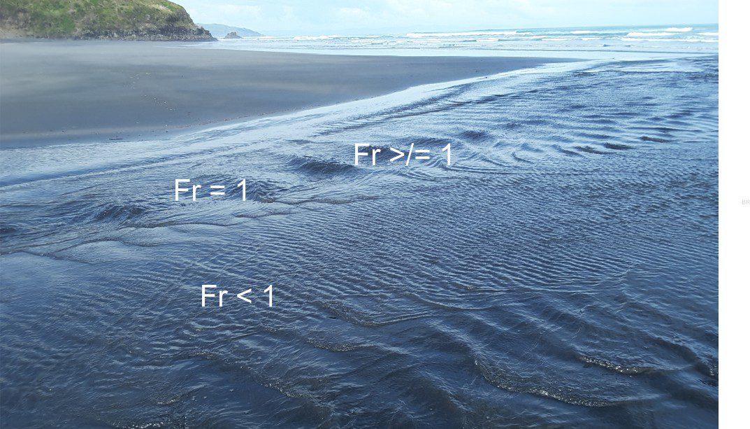
Tranquil flow: See subcritical flow.
Transcurrent faults: Major strike-slip faults that are generally confined to thin-skinned crustal deformation. Cf. Transform faults.
Transfer zone: The location along a fault where displacement is transferred to a neighbouring fault. Thus, displacement along the initial fault dies out, and its neighbour takes up the strain.
Transform fault: One of the major types of plate boundary where two plates slide past each other in a strike-slip motion. If relative plate motion is oblique, then components of transtension and transpression will occur. They are lithosphere-scale structures. Classic examples include San Andreas Fault in California that separates the North American plate from the Pacific Plate, and the Alpine Fault in New Zealand, separating the south Pacific and Australian plates. Dextral (right-lateral) strike-slip displacement along Alpine Fault is about 600 km.
Transgression: An advance of the sea over land as sea level rises, and the accompanying landward migration, or retrogradation of shorelines and associated marine sedimentary facies and biotas. The process of transgression may result in landward-progressing erosion, or ravinement. On a standard sea level curve transgression begins soon after baselevel begins to rise if the rate of sedimentation exceeds accommodation.
Transgressive surface: See Maximum regressive surface.
Transgressive systems tracts (TST): Form during rising sea levels where accommodation exceeds sedimentation rates. The base is a maximum regressive surface (MRS); the upper bounding surface is the maximum flooding (MFS). The TST overlies the HST and, where it is developed, the FSST. Depositional systems commonly include fluvial, delta and shelf strata.
Translation (kinematics): Strain, or deformation of a rigid body that involves fracturing and dislocation. In many situations there is also a component of rotation.
Transpression: A combination of strike-slip (dominant) and convergence developed at convergent plate boundaries.
Transtension: A combination of strike-slip (dominant) and extension; also called oblique slip. Most major strike-slip faults have a component of transtension or transpression. Transtension is developed at divergent plate boundaries (continental or oceanic rifts) and extensional components of orogenic belts.
Triangle zone: In a foreland fold-thrust belt context, it defines a wedge-shaped, subsurface deformation front having a basal thrust (the main décollement) and a hinterland-dipping roof thrust. The roof thrust is commonly passive.
Triple junction (plate tectonics): A point where three plate boundaries converge. Potentially, it can be any combination of the three basic boundary types: spreading ridge (R), trench (T), and transform fault (F). Certain boundary combinations are more stable than others, for example a RRR triple junction is always stable; whereas a FFF is mostly unstable (because of opposing relative motions).
Triple point: On a phase diagram, it is the point in pressure-temperature space where solid, liquid and gas phases of a compound coexist.
Trough crossbed: Defined by its concave, spoon-shaped basal contact that truncates previously formed crossbeds. Foresets have a similar geometry and generally are tangential with the base. Also called a 3D subaqueous dunes. They are common under conditions of confined, channelised flow.
Tropopause: The boundary between the troposphere and stratosphere – it marks changes in the dynamics of air flow from mixed (troposphere) to stratified, abrupt temperature gradients, and some chemistry (e.g. ozone). It averages 16-18 km high over the tropics, and 6-8 km over the poles, but changes seasonally and with weather systems. It is an important boundary for high altitude volcanic eruption columns.
Troposphere: The lowest layer if air – the layer we live in. It contains most of the water vapour; it determines most of our weather. It is a layer of fluid mixing; Cf. the Stratosphere.
Tsunami: (plural Tsunamis). A wave generated by a sudden pulse of energy – an earthquake, subaerial and submarine landslide, volcanic eruption or sector collapse, or asteroid impact.The waves can travel at speeds of several 100 km/hour. In mid ocean they may pass unnoticed, but increase in amplitude across a shallow shelf as they interact with the sea floor. Tsunamis act as shallow water waves. Waves on open coasts may be many metres high; in confined embayments like fiords, they can reach 10s to several 100 m high. Wave run-up extends to even greater heights.
Tufa: A natural, surface precipitate of calcium carbonate in alkaline lakes, rivers, springs and geothermal hot pools, promoted by degassing of CO2 as the waters exit to the surface. Degassing of CO2 results in an increase in pH, and concomitant increase in the stability of CO32- and HCO3– aqueous species and the degree of calcite saturation. It is also possible that microbial activity also promotes precipitation. Tufas tend to be highly porous; they can encase dead critters and vegetation. Travertines are a denser form of surface calcite precipitation. Extensive deposits are typically terraced.
Tuff: This is a volcaniclastic rock name restricted to tephras that are finer-grained than 64 mm. The term can be qualified with prefixes such as fine ash tuff, or medium lapilli tuff. The lithified equivalent for block/bomb tephras is volcanic breccia.
Tulip structure: See flower structures.
Tundra: A region that is treeless because of extreme cold and where growing seasons are brief. Although treeless, they are home to many grasses, low shrubs, and flowering plants that support a variety of wildlife. In mountainous regions, tundra is located at elevations above the tree-line. Vast expanses of tundra occur in the Arctic and subarctic. Tundra is commonly underlain by permafrost. It is the coldest of all biomes.
Turbidity current: A sediment-water mixture that flows downslope under the influence of gravity. The sediment mix is most commonly sand, silt, and mud. During flow, sedimentary grains are kept in suspension by turbulence. Scouring of the underlying bed may occur at the head of the flow. Deposition from turbulent flow produces graded bedding plus a characteristic suite of sedimentary structures exemplified by the Bouma Sequence. They form in lacustrine and marine settings that have modest depositional slopes. In marine environments, they are generated on continental slopes and in submarine canyons; they are one of the main components of submarine fans.
Turbulent flow: Turbulence is described by flow lines that constantly change direction and velocity. In a flowing stream this is manifested as eddies, boils, and breaking waves. In sedimentary systems, turbulence is an erosive process, and an important mechanism for maintenance of sediment suspension through water columns and in sediment gravity flows. It was first quantified by Osbourne Reynolds for conditions where Reynolds numbers Re > 2000
Twinning (crystallography): A symmetrical intergrowth of two separate crystals of the same mineral, that share the same mineral lattice. In thin section under crossed nicols, each individual will go into extinction at different rotations of the microscope stage. The kind of twinning, and its optical properties are important defining characteristics for mineral identification.