 Please note – I no longer maintain Glossaries by alphabet; A, B, C… etc. All items on these pages have been moved to subject-specific glossaries such as Volcanology, Sedimentary facies and processes, and so on. The list of subject-based glossaries can be viewed in the drop-down menu on the navigation bar. These glossaries are continually updated.

Genetic sequences: An alternative to the standard Exxon sequence stratigraphic model, introduced by W. Galloway (1989). Genetic sequence boundaries are bound by maximum flooding surfaces, rather than subaerial unconformities. They are based in part on D. Frazier’s (1974) depositional episodes, that begin with a period of progradation and end with transgression (maximum flooding).
Geochronology: The study of rocks and minerals to determine their age. Modern techniques use the decay profiles of radioactive isotopes, particularly uranium, lead, thorium, and potassium, to give us numerical ages (in comparison fossils provide relative ages).
Geofluids: Below the watertable (local or regional) all sediment and rock is saturated with fluid – aqueous, or non-aqueous. Geofluids include:
- Fresh and saline water (aqueous fluids in aquifers and aquitards) and hydrocarbons (oil and gas).
- Depth of flow ranges from near surface to the deepest parts of the crust.
- Rates of fluid flow rates range from cm/second near the surface, to cm/million years deep in the crust.
- Aqueous fluids are involved in all chemical reactions and distribute dissolved mass through the crust, including those that form rocks, hydrocarbons, and ore deposits.
- Fluids play an important role in how the earth deforms by reducing shear strength and elevating fluid pressures.
- Hydrous igneous melts have lower melting points.
Geographic poles: The points where lines of longitude converge, north and south. These poles are close to Earth’s pole of rotation; the coincidence is not exact or permanent because Earth wobbles about the rotation axis. Cf. Magnetic poles.
Geohistory: A numerical analysis that attempts to tease apart the different components of basin subsidence and basin accommodation space. The method developed by Van Hinte (1978) calculates the effects of compaction (decompaction), bathymetry, and sea level change. The contribution to total subsidence by tectonics is determined by backstripping the sedimentary column – this method was developed by Watts and Ryan, 1976.
Geoid: A hypothetical surface of equal gravitational potential, that coincides with sea level in the absence of tides, waves, currents, and changes in air pressure. Sea level in this context is an ideal surface. Because it depends on gravitational potential, the geoid, and therefore sea level will not be a smooth surface, but will have long wavelength hill and valley like relief. Satellite altimetric measurements if sea level are referenced to the geoid.
Geopetal: Textures and fabrics that allow the interpretation of stratigraphic top, or ‘way-up’. This definition would include normal grain size grading in a turbidite. However, there is a tendency these days to restrict the meaning to structures where cements or sediments partially fill a void, such that the top of the fill represents a depositional or precipitation surface. Examples include fossils that have preserved chambers, the interstices between pillow lavas, and cavernous porosity in reef frameworks or caves.
Geosyncline: The term coined in the 19th century for basins containing great thicknesses of sedimentary rock. Early hypotheses, popularized by folk like J. Dana, James Hall, and Marshall Kay, linked geosynclines to orogenic belts as cause and effect, rather than just being exposed in mountain uplifts. Eugeosynclines were deep-water oceanic basins, commonly bordered by an uplifted ridge or geanticline; Miogeosynclines, or miogeoclines were relatively shallow water sedimentary depocenters, likened to passive margin sedimentary prisms. Interpretations of thick sedimentary successions were frequently forced to comply with geosynclinal models. One of the major problems with these models was a general lack of modern analogues. The advent of plate tectonics and the recognition of basins associated with plate interactions, rendered the terms redundant.
Geostatic pressure: An alternative term for lithostatic pressure.
Geothermal gradient: Temperature generally increases with depth in the crust; the gradient for a particular location is stated as the temperature increase per unit depth. The global average is 3o C/ 100 m although there can be large departures from these values in regions of geothermal and volcanic activity, or regions that have cooled significantly over geological time, such as old oceanic crust.
Ghyben-Herzberg equation: (hydrogeology)
z = h.ρf / ρs – ρf
where z is the depth to the interface from sea level, h the watertable elevation, ρs (1.025 gm/cc) and ρf (1 gm/cc) the densities of seawater and freshwater respectively, such that:
z = 40h
This relationship is an important approximation of the interface between freshwater and seawater in coastal aquifers. The equation states that for every unit decrease or increase in watertable depth (h) there will be a corresponding 40 unit rise or fall respectively in the interface between seawater and freshwater. In practice, it provides a reasonable approximation of potential seawater intrusion into coastal aquifers that have been over-produced.
Gilbert delta: Originally described by G. Gilbert for coarse-grained deltas that display a 3-fold architecture: horizontal to shallow dipping topset beds (analogous to a delta plain), foresets beds, and bottom set beds. They form where coarse bedload rivers empty into lakes and marine basins. They are included in the general category of fan deltas.
Glacial outwash: Deposits, usually coarse-grained, deposited downstream of glacier ice fronts by fluvial processes. Streams are commonly braided. Outwash streams may be linked to subglacial channels. Small outwash fans may also form where subglacial streams exit the ice. Outwash streams and fans may drain into or from lakes.
Glacial striae: Grooves and scratches produced by ice-drag of rocky clasts over a subglacial bedrock surface. Measurement of striae bearings provides useful information on ice flow directions.
Glaciofluvial: A broad term that includes a variety of fluvial environments and processes associated with glaciers, ice caps and ice sheets. This includes subglacial and other ice contact deposits (such as eskers), as well as outwash streams originating at ice fronts. Most are coarse-grained.
Glaciolacustrine: Lakes that form from glacier or ice cap meltwaters, and receive glacial outwash sediment. Lakes may be located in antecedent drainage lows, or damming of outwash streams by ice or landslides. Coarse-grained deposits will form as beaches or small deltas (e.g. Gilbert-type deltas). Mud carried by outwash streams will settle in the lower energy parts of lakes. Lake varves are a characteristic product of seasonal freeze-thaw.
Glacio-isostatic rebound: The isostatic response where a landmass elevation rises following the melting and removal of an ice sheet. Evidence for rebound is commonly observed as raised beaches. Well-known examples of post-glacial rebound where uplift continues today are Scandinavia and Hudson Bay.
Glowing avalanche: A hot pyroclastic flow that reveals a glowing flow head as it careens down the volcano slope. Also called Nuées ardentes.
Goldilocks zone: The zone around a star in which orbiting planets maintain conditions for life to evolve. Earth is the primary example, where conditions are neither too hot or too cold. The zone depends on the planet’s orbit (distance) the size of the star, and atmospheric greenhouse condtions. Exoplanets can be categorized as having the potential for life forms, according to these conditions.
Graben: A fault depression or basin formed between paired, normal dip-slip faults. The downward displaced hanging wall block is common to both faults. The adjacent upthrown blocks are horsts. They form in regions of extensional tectonics, such as rift zones. Cf. Half graben
Graded bedding: A depositional unit in which there is an upward decrease in grain size (normal grading). This structure is indicative of deposition from turbulent sediment-water mixtures; it is one of the defining characteristics of turbidites.
Grain flow: Sediment gravity flows consisting mostly of sand, in which the primary mechanism of grain support are dispersive pressures generated by grain-to-grain collisions. Maintenance of grain flows requires relatively steep slopes compared with debris flows and turbidity currents.
Grain size: There are several ways to measure the size of clasts: grain diameters (maximum, intermediate, minimum), surface area, or by using the assumption that grains approximate spheres. Sieve sizes use the minimum diameter where a grain will pass through a particular mesh. The most popular scale is the Wentworth scale, based on a geometric progression of sizes, centred on silt and sand populations. An important modification of the Wentworth model is the Phi scale (Φ), calculated as Φ = -Log2 of the grain size in millimetres.
Grain size distribution: A measure of the size distribution of particles in granular sediments. Measurement of the range of grain sizes in a sample provides data for detailed descriptions, calculation of population statistics such as mean, mode, and sorting, and may even provide clues to deciphering depositional hydraulics.
Grainstone: The cousin to siliciclastic sandstones, where sand-sized carbonate particles (<2 mm) form a grain-supported framework, relatively free of or carbonate mud (micrite).
Dunham’s (1962) limestone classification scheme reviewed and modified by Lockier and Junaibi (2016).
Gravel: The unconsolidated equivalent of conglomerate, comprising clasts coarser than 2 mm. The general class is divided into granules (2-4 mm; -1 to -2 phi); pebbles (4-64 mm; -2 to -6 phi); cobbles (64 – 256 mm; -6 to -8 phi); and boulders (larger than 256 mm).
Gravitational friction: Also called tidal friction. The gravitational pull on Earth by the Moon (principally) and to a lesser extent the Sun and other planets, causes minor distortion in Earth’s shape. This pull-push effect is enough to generate frictional heating of Earth’s interior. The effect is also known to be important on other celestial bodies, particularly Jupiter’s moon Europa and Saturn’s Enceladus, where the frictional heat may be sufficient to maintain a liquid ocean beneath its frozen surface. It is one of three heat sources on Earth – the other two are radiogenic heat and primordial heat.
Greenhouse effect: The heating of an atmosphere when gas molecules absorb certain frequencies of solar infrared energy. On Earth this involves water vapour, carbon dioxide, methane, and to a lesser extent nitrous oxide. Molecular oxygen and nitrogen do not absorb infrared energy. Carbon dioxide and water vapour absorb energy at different frequencies. Note that the amount of water vapour in the atmosphere depends on temperature, unlike carbon dioxide.
Greywacke: A muddy sandstone having 15-75% muddy matrix. Typically they are poorly sorted, and contain grains having variable roundness-angularity. It can be difficult distinguishing between original matrix (detrital) and diagenetic cements, particularly with the recrystallization of clays, the transformation of illite to white mica, and the addition of minerals like chlorite. Likewise, distinguishing between lithic fragments and diagenetically altered matrix can be difficult. Greywackes are commonly highly indurated.
Gridiron twinning: A common diagnostic twin in potassium feldspars twins that belongs exclusively to microcline. It is presented as a cross-hatching of thin albite and perthite twin lamellae. Also called tartan twins.
Groove casts: Straight to slightly arcuate furrows formed when objects are dragged across a soft sediment surface. The grooves are subsequently filled with sediment and exposed as casts at the base of the overlying bed. Groove casts provide ambiguous paleocurrent azimuths (180o apart). They are common at the base of turbidites, and frequently accompany other sole marks like flute casts, roll and skip marks.
Groundwater: Water that resides in porous and permeable sediment and rock beneath the surface. The term applies equally to fresh and saline waters, in aquifers and aquitards at any depth in the crust. The term does not apply to chemically bound water, although such water may be released to groundwater during diagenesis and metamorphism. See also aquifer, hydraulic gradient.
Groundwater discharge: Natural discharge of groundwater as springs, seeps, or baseflow, at the surface or in streams, lakes, or the sea floor. Discharge occurs where the watertable (unconfined aquifers) or potentiometric surface (confined aquifers) intersect the land or water body surface, and the hydraulic gradient is sufficient to drive flow. Cf. Groundwater recharge.
Groundwater recharge: The infiltration of water from precipitation into an aquifer. For unconfined aquifers this recharge occurs at the watertable. For confined aquifers recharge occurs by slow seepage from the confining aquitards.
Groundwater residence time: The time from recharge (usually at the surface) to discharge. Residence times are briefest in unconfined aquifers, ranging from days to years. In regional groundwater flow systems these times are measured in 105 to 106 years. Groundwater dating utilises trace compounds such as fluorocarbons, isotopes like ³H (tritium from atmospheric atomic device testing), and cosmogenic isotopes such as Carbon-14, and Beryllium-10.
Growth fault: Faults having a listric geometry, that are active during sedimentation. Stratigraphically they are represented by preferential sediment thickening above the downward displaced hanging wall block, and angular stratigraphic discordances. They are common on shelf, platform, and delta margins.
Grykes: Elevated blocks of limestone bound by fracture networks, or clints. They are common in karst landscapes.
Gutter casts: Straight scours several centimetres deep, that in some cases may represent erosion downflow of objects on the depositional surface, and in others the product of helical flow or eddies. Like other sole marks, they present as casts on the base of an overlying bed.
Gypsum divide: The stage during evaporation of brines where gypsum precipitation determines the succession of minerals in waters subsequently depleted in Ca2+ and SO42-. It determines whether the brines evolve as SO4 rich – Ca poor, or SO4 poor https://www.geological-digressions.com/mineralogy-of-evaporites-saline-lake-brines/

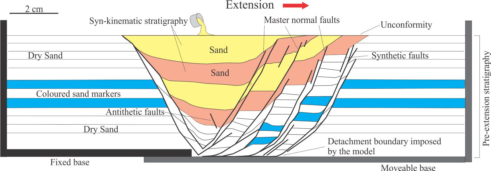
Half graben: A depression or basin formed by extension, and (usually) rotation of a hanging wall block above a single, normal dip-slip fault (cf. paired faults in grabens). They commonly form above listric faults in continental rift zones, but analogous structures also form in rotational slumps.
Half life: The time taken to reduce a quantity of a radioactive isotope by half. This means that after one half life, it is probable that 50% of the isotope will remain; after the second half life 25%, and so on. Isotope decay is exponential.
Halides: Anions of the Chemical Periodic Table halogen group: Fluoride F‾, chloride Cl‾, bromide Br‾, Iodide I‾, and astatide At‾. Many inorganic halides are water-soluble; most organic halides are not.
Halokinesis: Halokinesis, or salt tectonics, studies the movement of (stratiform) salt during burial, the kinds of diapiric structures that form, the response of the surrounding bedrock (such as faulting), their impact on depositional processes, and their influence on stratigraphic architecture.
Hanging wall: Displaced fault blocks across a dipping fault plane are described as hanging wall and foot wall blocks, depending on whether they are located above or below the fault plane. Hanging wall blocks lie above – if you are standing on the fault plane, the hanging wall block will hang over your head. The term derives from old mining jargon.
Hanging wall cut-off: The intersection point of a marker layer or bed in the hanging wall block that is truncated by a fault. It is used in conjunction with the corresponding foot wall cut-off to determine fault slip.
Hardness (mineralogy): A measure of a mineral resistance to scratching. The common Moh Scale has hardness gradations from 1 – the softest (e.g. talc), to 10 (diamond). The scale does not include mineral propensity for breakage (along cleavage planes). Common indicator minerals are (increasing hardness):
1 Talc 2 Gypsum 3 Calcite 4 Fluorite 5 Apatite 6 Orthoclase
7 Quartz 8 Topaz 9 Corundum 10 Diamond.
Hawaiian eruption: Effusive eruptions of fluid basaltic lava in lava lakes and associated flank fissures. VEI = 0-1. Flows are mostly pahoehoe type.
Head loss: Fluid flow through pipes or an aquifer will only take place if there is an energy gradient from one location to another. In hydraulics, this is represented by the change (decrease) in hydraulic head. If the head loss can be measured, then the local hydraulic gradient can be calculated.
Heat flow: The transfer of heat from Earth’s core and deep mantle to the surface, primarily by conduction and convection. It is expressed as milli-Watts per square metre (mWm-2).
Heavy minerals: A broad group of minerals having specific gravities 2.9 and greater (quart and feldspar are 2.6), that make up <1% of most arenites; exceptions are iron sands (high proportions of magnetite and ilmenite) and some volcanic sands with abundant pyroxenes and olivines. Common groups include tourmalines, zircon, sphene, amphiboles, pyroxenes, micas, iron oxides, and other ferromagnesian minerals like olivine. They are important for assessing sediment provenance. Zircon is important because it is both mechanically and chemically stable, and it contains measurable Uranium and lead isotopes making it useful for dating and tracking potential source rocks.
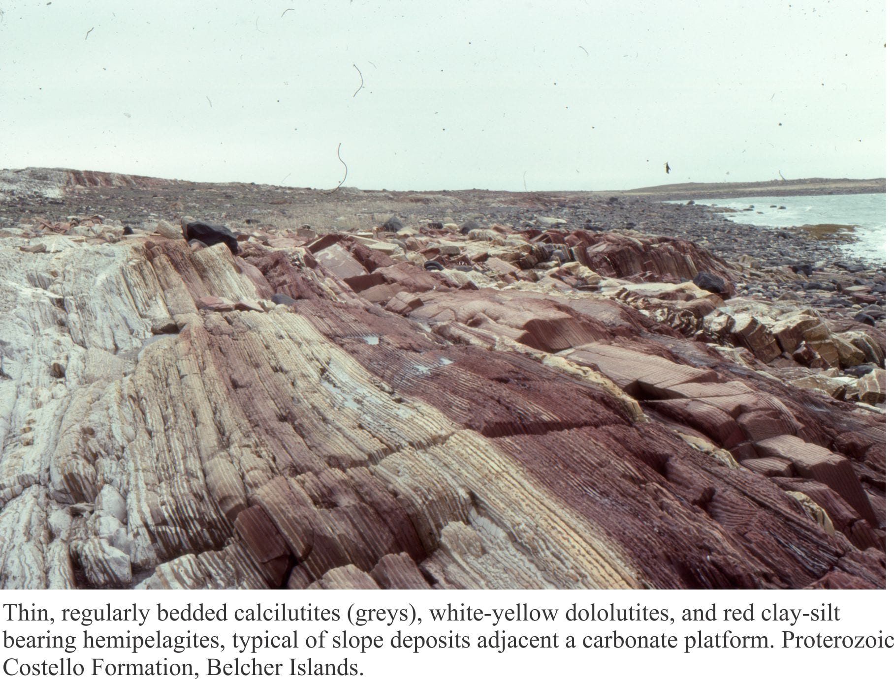
Hemipelagic sediment: Very fine-grained siliciclastic sediment (clays, silt) that is deposited from suspension in the ocean water column; it may be mixed with pelagic sediment. Hemipelagite tends to accumulate in relatively deep-water slope, rise, and ocean basins remote from strong bottom currents.
Herringbone crossbedding: Two crossbed sets, one above the other, where the foresets in each dip in opposite directions. The opposing foresets can be interpreted as representing tidal current asymmetry – one set formed during flood tide, the other during ebb tide. This structure is best identified where the 3-dimensional attributes of bedforms can be observed to avoid the ambiguity of apparent foreset dips.
Heterotroph: An organism that requires the assistance of other organisms to generate energy and food. In other words, they eat other heterotrophs and autotrophs. The group includes omnivores, herbivores, carnivores, and critters or plants that use decomposition processes.
Hiatus: (plural hiatuses). A stratigraphic surface that records a break in sedimentation. A hiatus can be any duration. A depositional hiatus may be a few minutes or 1000s of years. The hiatus recorded by angular unconformities can be many millions of years. The term was introduced by A.W. Grabau to describe the absence of a rock record between pulsations, or cycles. See also Lacuna.
Highstand systems tract (HST): Formed during the late stage of relative sea level rise and the beginning of sea level fall. Depositional systems that make up the HST can include fluvial, delta, barrier island – lagoon, coastal, and shelf deposits. The lower boundary is a maximum flooding surface. The upper boundary is a sequence boundary that includes the subaerial unconformity, and offshore the basal surface of forced regression (FSST). The HST underlies the FSST and overlies the TST.
Hinge line: A line defined by points of maximum curvature (hinge points) connected along a fold surface; the hinge line may be straight or curved. It is used with an axial surface to define the geometry of a fold. Cf. Fold axis. See also axial plane.
Hinterland: In collisional orogens, the mountainous region in the upper plate underlain primarily by metamorphic core complexes and crystalline rocks. The hinterland is separated from the cratonward foreland by a collisional suture zone. Hinterland lithosphere may be arc or continent related.
Hogback: A sharp-crested and symmetric ridge produced by differential erosion of resistant layers underlain by less resistant rocks. One side of the Hogback is a dip slope (dips > 25°-30°) underlain by resistant rock; The other side of the ridge is underlain by softer rock.
Holomict: Lakes or seas in which there is mixing of surface and deeper waters. Bottom waters tend to be oxygenated Cf. Meromict.
Horse: A panel of rock bound on all sides by thrusts. Duplexes are a stack of horses.
Horsetail splay: A splay of curved faults at the end of a strike-slip fault, where each strand merges with the master fault.
Horst: See Graben.
Hummocky cross-stratification: (HCS). Low relief, laminated, mound-like bedforms and intervening troughs or swales. Mound amplitudes are only a few centimetres, and intermound spacings of 2-4 metres. They are mostly fine-grained sandstone, but may contain basal pebble layers. Successive generations of HCS truncate underlying bedforms. HCS forms during storms where unidirectional flowing bottom currents, possibly as sediment gravity flows generated during storm surges, are simultaneously moulded by the oscillatory motion of large storm waves. They are good indicators of storm wave-base. Their preservation potential above storm wave-base (i.e. over the shoreface) is low.
Hyaloclastite: Fragmental volcaniclastics that form when lava is quenched rapidly under water, beneath ice, or in saturated sediment, such that is shatters into angular fragments. Hyaloclastitic debris is commonly glassy and highly angular, with straight, arcuate, or bubble texture margins.
Hyalotuff: Fragmental deposits formed by explosive, phreatomagmatic eruptions when magma comes into contact with seawater or groundwater. Ash particles are generally angular and commonly have bubble or vesicle textures. Cf. Hyaloclastites.
Hydraulic conductivity (hydrogeology): This is the proportionality constant in Darcy’s Law. It has dimensions of length/time. Hence it is also called the Darcian velocity. It is a measure of the ease with which a fluid will flow through a porous medium. Importantly, it is a function of the porous medium and the fluid, particularly the fluid viscosity. This means that oil flowing through an aquifer will have a lower hydraulic conductivity than water through the same medium. Hydraulic conductivity is used in all hydrogeological studies. In contrast, the oil and gas industry uses a different proportionality constant – the Darcy, that depends only on the porous medium.
Hydraulic gradient (hydrogeology): The change in hydraulic head from one location to another can be stated as a gradient, which is the head difference divided by the distance between the two locations. Gradients can also be calculated from contoured potentiometric surface maps. Groundwater always flows towards locations at lower head.
Hydraulic head (hydrogeology): Also called hydraulic potential, is a measure of the potential energy available to drive groundwater flow. From Bernoulli’s equation, the total head is:
HTotal = h (the elevation head) + P (pressure head)/ρg
For which the dimensions are in units of length, or height/depth measured to some datum. The total head is the same anywhere along a line of equal potential (equipotential); however, the elevation and pressure head components change.
Hydraulic head – elevation head (hydrogeology): If the point of measurement is the bottom of a borehole, then the elevation head is the depth from this point to the datum. It is a component of the total head measured at that point; the other component is the pressure head. The point of measurement can be anywhere along the line of the borehole. In most cases, this line will represent an equipotential. For example, if the point of measurement was the watertable, then total head would be made up entirely of the elevation head; the pressure head would be zero.
Hydraulic head – pressure head (hydrogeology): If the point of measurement is the bottom of a borehole, then the pressure head is the depth from this point to the watertable or other equipotential surface. It is a component of the total head measured at that point; the other component is the elevation head. The point of measurement can be anywhere along the line of the borehole. For example, if the point of measurement was the watertable, then total head would be made up entirely of the elevation head; the pressure head would be zero.
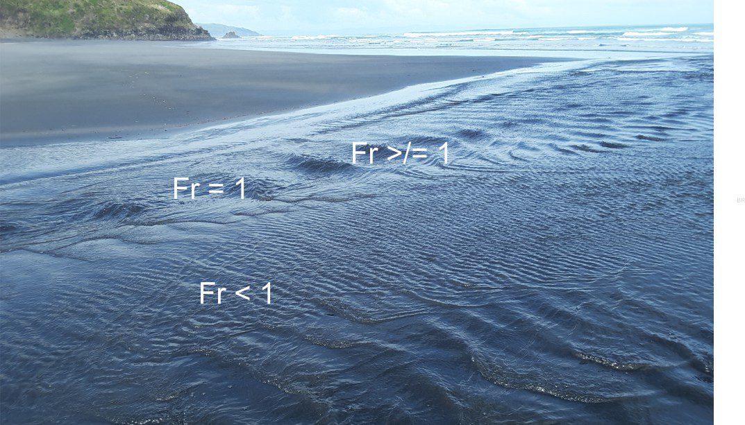
Hydraulic jump: A region of turbulence that develops in channels when Upper Flow Regime conditions slow to Lower Flow Regime.
Hydraulic potential (hydrogeology): The statement of hydraulic potential derived from Bernoulli’s equation is a statement about the potential energy that drives groundwater flow. Mathematically this simplifies to potential energy E = ρgz + fluid pressure P (ignoring the kinetic energy component), where ρ = fluid density; g = gravity constant; z = depth relative to a datum. The more common expression for this is hydraulic head.
Hydraulics: A general term for the conditions promoting flow in water, air, and sediment-water mixtures, and the processes of sediment movement and deposition. Involves consideration of flow velocity, turbulence, laminar flow, frictional drag, and shear stress.
Hydrogeology: The study of subsurface fluids, particularly groundwater and its utilization,, aquifers and aquitards, fluid chemistry, its influence on rock strength and slope stability, its role in tectonics, hydrocarbon migration and trapping, and mineralization.
Hydrolysis: Also called dissociation. The reversible reaction where H20 splits into a hydrogen ion and a hydroxyl ion, as in H20 = H+ + OH–. The equilibrium constant is written as:
Kw = (H+).(OH–)/( H20). The activity of H20 is usually taken as 1.0, so that Kw = (H+).(OH–). At 25ºC K= 10-14.0 . Where the concentration, or activity of (H+) > (OH–) is acidic, and (H+) < (OH–) is basic. This is the basis for the pH scale, calculated as the -log10 of the activities.
Hydrostatic pressure: At any depth, the pressure exerted by a (theoretical) overlying column of water having unit-area cross-section, is calculated from the expression P = ρgz where ρ = density of water, g = gravity constant, and z = depth from some datum, commonly sea level. Note that, assuming a cross-section of unit-area reduces volume to units of depth. It is analogous to lithostatic pressure.
Hyperconcentrated flow: Sediment laden flows that behave mechanically between two end-member flow types: normal stream flow with little or no suspended sediment load, and debris flows having high matrix content. Hyperconcentrated flows have no yield strength, like water, but do have a viscosity that depends on strain rate. Rheologically, they behave somewhere between a Newtonian fluid and a plastic (or hydroplastic). A typical example is a mud-laden river flood. https://www.geological-digressions.com/sedimentary-structures-alluvial-fans/
Hypersaline: Having salinity greater than seawater (>35 parts/1000). Modern hypersaline environments are most common between the tropics but are found in such diverse places as the Antarctic dry valleys. Plant and animal life require specialized adaptations to survive these conditions. Prolonged hypersalinity may result in evaporite deposits in lakes and seas.