 Please note – I no longer maintain Glossaries by alphabet; A, B, C… etc. All items on these pages have been moved to subject-specific glossaries such as Volcanology, Sedimentary facies and processes, and so on. The list of subject-based glossaries can be viewed in the drop-down menu on the navigation bar. These glossaries are continually updated.

Lacuna: Introduced by Harry Wheeler (1964), it encompasses the total time missing at the unconformity, and is divided into an hiatus which is a non-depositional or erosional episode above the unconformity, and an erosional or degradational vacuity below it (i.e. the time represented by rocks removed by erosion). The contact separating these two domains is the base level transit, which defines stratigraphic onlap and offlap geometries. These concepts pre-empted by about 20 years the fundamentals of sequence stratigraphy.
Lagoon: A shallow bay protected from ocean swells, and to some extent storms, by barrier islands, spits, and bars. Extensive tidal flats commonly border the landward margins of lagoons, crossed by estuaries and small tidal channels. In tropical and temperate climates, mangrove swamps provide breeding grounds for all manner of critters. There is regular tidal exchange of ocean seawater through large channels; delta platforms at the inner or seaward channel exits are called flood- and ebb-tidal deltas respectively. There is a continuous exchange of sediment (mostly sand) between the lagoon, barrier and coastal dunes, and the open sea shelf.
Lahar: A terrestrial gravelly mudflow, or debris flow consisting largely of volcanic debris. Most flows are initiated on the flanks of volcanoes. They develop during and after eruptions, initiated by seismic tremors, or periods of high rainfall that saturate soils and reduce their shear strength. Lahars are capable of carrying vehicle-sized blocks and can be very destructive. Flow run-out is commonly several kilometres. Cf. block and ash flow.
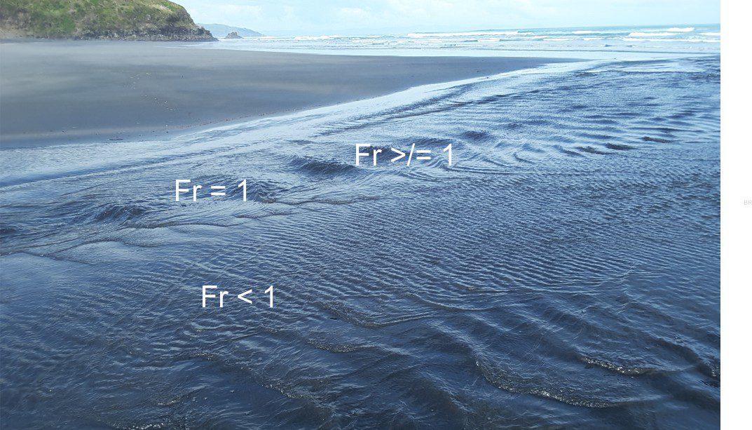
Laminar flow: Defined and quantified by Osbourne Reynolds, laminar flow is described conceptually as flow lines that are parallel, or approximately so, and relatively straight. The flow velocity will be the same across each flow line. Expressed in terms of Reynolds numbers (Re), it is the flow condition when Re < 2000. The transition to turbulent flow is usually abrupt.
Lapilli: Primary volcaniclastic particles, derived directly from volcanic eruptions, and ranging in size from 2 mm to 64 mm. See Accretionary lapilli.
Lapout: The geometry of stratigraphic termination of clinoforms relative to some through-going surface. Although these can be observed in some outcrops, seismic reflection profiles provide the best opportunity to identify lapout classes. See Onlap, Downlap, Offlap, Toplap.
Lateral blast: An ground-hugging eruption that is triggered by the collapse of a volcanic flank or lava dome. These blasts produce hot, fast-moving block and ash flows, pyroclastic density currents and pyroclastic surges. Mt. St. Helens eruption in 1980 is an iconic recent example.
Lateral linkages (stromatolites): Laminae that extend from one stromatolite dome or column to its neighbours and covering the intercolumn sediment.
Lateral moraine: The accumulation of rocky debris at the surface of glacier margins, derived by scraping and erosion of adjacent bedrock valley walls. They form as parallel ridges in the ablation zone of glacier margins. As deposits they are characteristically a very poorly sorted mix of rock flour to boulder size, angular clasts.
Lateral Ramps: Fault ramps at right angles or oblique to the strike of a thrust complex that transfer displacement from a lower to higher flat. Fault planes dip 10o to 30o. As shown in the diagram below, fault displacement across the ramp is basically strike-slip.
Laths (igneous petrography): Very small needle-like crystals commonly set in very fine or glassy groundmass. Aphanitic volcanic rocks may have abundant feldspar laths; alignment of crystals during lava flow is common.
Laurentia: Laurentia and Gondwana were the two major continental blocks that split from Pangea supercontinent. Laurentia originally was an amalgam of North American, Greenland, and northwest Scotland. Beginning about 175 Ma, the North American-Greenland portion of Laurentia split from Pangea, leaving the Scottish sliver behind.
Lava dome: Hemispherical to spine-shaped extrusion of viscous magma in the craters or upper flanks of volcanoes. Lava domes are inherently unstable: debris derived from lava cooling and cracking may spall and accumulate at the dome base; or domes may collapse under the influence of gravity or from internal pressures. Dome collapse commonly generates block and ash flows, or hot pyroclastic flows and surges. Cf. endogenic and exogenic domes.
Lava dome collapse: Domes of viscous lava that grow on volcano summit craters or flanks are inherently unstable. Their collapse from gravitational instability or internal pressures can generate PDCs, commonly as block and ash flows, or pyroclastic surges.
Lava lake: The accumulation of lava in summit craters. Eruption may be quietly effusive, or as fire fountains from fissures around the crater walls. Crusts that form rapidly on the lake surface are usually broken by lava surges and reworked into the melt. When activity ceases the lava solidifies into a solid plug.
Lava tube: Long, tunnel-like openings through which lava flows; primarily in basaltic pahoehoe lavas. They usually begin life as open lava streams where crust mantles gradually coalesce into a more solid roof. Tubes commonly branch to form networks. When flow ceases, the lava may drain leaving the tube open, or solidify within the tube. The roof of a tube can collapse at any time during or after lava flow.
Lebensspuren: The German word for traces and trace fossils left by animals on or within the sediment.
Lee face (bedforms): The steep, angle of repose face on bedforms, such as ripples and sandwaves, that faces down-flow. Bedload is moved up the stoss face (upstream face) to the bedform crest, and subsequently avalanches down the lee face. Immediately downstream of the lee face is a region of relatively low fluid pressure that is detached from the main flow.
Lenticular crossbedding: Sand ripples that occur as single bedforms within laminated mudstone. They commonly occur with flaser beds. They are commonly found on tidal flats and shallow, low energy subtidal environments such as in lagoons. Together, the bedforms provide evidence for tidal current asymmetry.
Levee: Natural levees are linear, mound-like deposits that accumulate along the banks of many fluvial, delta distributary, tidal, and submarine channels; they act as a partition between an active channel and adjacent floodplain. Deposition occurs during channel flooding. If levee accretion is significant it may prevent regular flood plain inundation. Rippled and laminated fine-grained sand tend to be deposited during rising flood stages, and silt-mud veneers during waning flow stages. In some cases, vegetation will stabilise the levee, and dampen overbank flow to the floodplain. Levees that rim submarine channels accumulate during the passage of turbidity currents. See crevasse splay.
Liquidus: The temperature at which there is complete melting of a solid; it is the maximum temperature at which crystals can coexist with their liquid melt. Note that the liquidus occurs at higher temperatures than the solidus.
Liquefaction: If water-saturated sediment is disturbed, for example by earthquake ground shaking, the grains begin to separate until they are ‘floating’ in the interstitial water. At this point, the fluid now consists not only of water but also the floating grains and a consequence of this is that fluid pressures increase. The sand is now liquefied. It no longer has shear strength and cannot support surface loads. Eventually the grains will settle and at this point the excess water will escape to the surface. Cf. dewatering, fluidization, sand volcanoes.
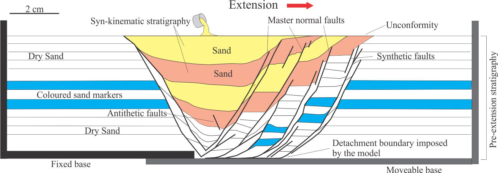
Listric fault: Listric faults are a product of extension. They have normal dip-slip(or oblique-slip displacements where fault surfaces are concave upward, dipping steeply near the surface and flattening at depth in a detachment that is common to other listric faults. They occur at crustal scales (e.g. continental rifts), and in smaller depositional systems such as deltas and slumps. Faulting is commonly incremental and can take place during sedimentation. Rotation or folding of strata in the hanging wall block results in multiple unconformities. Cf. Growth fault
Lithic (petrology): Also called rock fragments. A general term for clastic material that cannot be pigeonholed into the other main framework components like quartz and feldspar. It usually applies to fine grained lithologies such as mudstone and siltstone, or aphanitic, glassy volcanic rock (with or without small feldspar laths). Chert fragments present something of a problem in sandstone classifications because they consist of micro- and cryptocrystalline quartz; they are sometimes placed in the total quartz category, at other times in the lithics category.
Lithification: The combination of compaction and cementation that produces hard, hammer-ringing rock from loose, uncompacted sediment. Lithification depends on a complex association of physical and chemical processes. Cementation can occur at very shallow depths in the case of carbonates, or at different stages of burial depending on temperature, and rock – fluid chemistry. Compaction begins soon after deposition and continues at depth.
Lithosphere – the compositional version: Consists of the crust and mantle lithosphere. The lithosphere-asthenosphere boundary is defined by a low seismic velocity discontinuity.
Lithosphere – the rheological version: The lithosphere – asthenosphere boundary is defined by the solidus, a isotherm at 1100o-1330oC, that marks the transition to partial melting of mantle rock. This is manifested as the transition to mechanically weak ductile-viscous behaviour in the asthenosphere. Defined in this way, oceanic lithosphere is about 5 km thick at spreading ridges increasing to 90 km thick in older, colder oceanic lithosphere. Continental lithosphere commonly ranges from 100-250 km thick.
Lithostatic pressure: At any depth, the pressure exerted by the overlying column of rock and sediment having unit-area cross-section, is calculated from the expression P = ρgh where ρ = density of the rock column, g = gravity constant, and h = depth from some datum, commonly sea level. Note that, assuming a cross-section of unit-area reduces volume to units of depth. Also called overburden pressure. It is analogous to hydrostatic pressure.
Lithostratigraphy: Formal lithostratigraphy is concerned with the description and mapability of rocks, using physical, fossil, and mineralogical attributes. The basic lithostratigraphic unit is the Formation. There is no reference to time.
Littoral zone: The nearshore region of marine and lacustrine environments. In the marine setting it extends from high tide to shallow offshore depths. The term is used primarily to designate ecological environments for diverse marine organisms.
Load casts: Sole marks, or sole structures consisting of bulbous sand or silt structures that protrude into and deform underlying beds – they are most pronounced when protruding into mudrocks. Load casts, or load balls may become disconnected from the parent sand bed. They form during early compaction and are commonly associated with dewatering structures. Soft mud squished between load casts may produce wispy flame structures.
Lobe and cleft: Lobes, billows, and intervening pockets at the head of a PDC where turbulence is generated by frictional forces across the substrate and the contact with air.
Longshore drift: Drift of water masses, sediment, and swimmers occurs when waves approach a beach at an angle. Here, water moving up the beach (wave swash) returns farther along the beach. Longshore drift (or along shore drift) is an important coastal process that contributes to coastline straightening by sand bars, and to the formation of sand spits and barrier islands. See undertow, rip currents.
Lowstand Systems Tract (LST): Forms at the end of sea level fall and the beginning of sea level rise. Depositional systems include submarine fan, base of slope and mass transport deposits. The top of the LST is the maximum regressive surface; the base is the correlative conformity equivalent to the subaerial unconformity (also a sequence boundary).
Lysocline: The ocean water depth where the dissolution of calcite is first observed in sediment. Its identification requires detailed observation of dissolution textures and is somewhat subjective. It lies above the calcite and aragonite compensation depths; the lysocline should, theoretically, be close to the saturation levels for both minerals.

Maar eruptions: A phreatomagmatic, or hydromagmatic eruption caused by magma intruding shallow groundwater. These highly explosive events produce low-relief craters that extend beneath the local watertable and are capable of bringing deep basement rocks to the surface. They subsequently fill with water and form closed lakes or coastal embayments. Volcaniclastics usually include airfall and pyroclastic surge deposits. Accretionary lapilli are common. They may be linked to diatremes.
Magmatic arc: Also called volcanic arcs. A chain of volcanoes and associated intrusions that form in the plate above a subduction zone. Arcs generally parallel the deep oceanic trenches. At mantle depths, dewatering of oceanic crust in the subducting slab lowers the melting point of mantle rock. The partial melts rise because of buoyancy.
Magmatic eruption: Explosive eruptions where magma fragmentation is controlled by decompression of magma volatiles such as CO2 and water. Cf. phreatomagmatic, phreatic, effusive eruptions.
Magnesium calcite: Also called magnesian calcite. In the calcite crystal lattice, magnesium can occupy the position of calcium, up to about 20 mole percent. Two varieties predominate in carbonate sediments and limestones: Low magnesium calcites (LMC) with <4 mole % Mg), and high magnesium calcites (HMC) with 11-19 mole % Mg). HMC commonly recrystallize to LMC during burial diagenesis.
Magnetic field: Earth’s magnetic field is generated by a hot (4000-5000oC), fluid-like, iron-nickel rich outer core that moves slowly around a solid iron inner core. The field is forced into a tear-drop shape by solar winds, with the head of the ‘drop’ towards the sun (extending about 65,000 km), tapering over 600,000 km away from Earth. The magnetic field protects us from harmful components of the solar spectrum, like cosmic rays. The field has North and South poles that occasionally reverse over geological periods of 104 -105 years. The field intensity also waxes and wanes.
Magnetic poles: The points in a magnetic field where lines of equal magnetic intensity converge. On Earth, these poles are close to, but not coincident with the geographic poles; the magnetic poles also wander. During magnetic reversals the N and S magnetic poles switch places.
Magnetic reversals: Reversal of Earth’s magnetic field has occurred many times, and over the last few million years this has happened about every 200,000 to 300,000 years. The last reversal took place 780,000 years ago; this is called the Brunhes-Matuyama Reversal. Reversals are recorded by iron-bearing minerals in volcanic and sedimentary rocks where the minerals act as tiny magnets – the direction of polarity (i.e. magnetic N and S) is locked in mineral at the time of lava solidification or sedimentation, and this remnant magnetism can be measured.
Magnetostratigraphy: The formal stratigraphic measure is the magnetostratigraphic polarity unit that is used to subdivide and correlate rock units according to whether polarity is Normal (north pointing) or Reversed for a body of rock.
Mangrove: Flowering shrubs and small trees that are salt tolerant, living on sandy and muddy tidal flats and salt marshes. Most common between the subtropics but do extend beyond these latitudinal limits. They deal with salt uptake by excreting it from their leaves. They have complex root systems that help stability under conditions of shifting sediment and tides. Mangroves provide important habitats and breeding grounds, and also help protect coasts from storm wave surges and erosion. See also paralic, marsh.
Mantle plumes: A process of mantle convection involving the buoyant rise of asthenosphere; From lab experiments it has been learned that the shape of the plume depends on its viscosity – high viscosity leads to relatively narrow bodies, high viscosity to mushroom-shape bodies with tails. They are important forms of heat transfer and from partial melting, sources of magma.
Marsh: A wetland dominated by herbaceous plants, that is transitional between a lake or sea and terrestrial environments. In paralic settings they form salt marshes that are inundated during spring tides and contain plant species that have adapted to saline conditions, such as the succulent Salicornia. Fresh and salt water marshes are important habitats and breeding grounds for many vertebrate and invertebrate species. Cf. Swamp
Master fault: The primary fault or detachment in a system of faults such as splays, duplexes, imbricate fans, or synthetic and antithetic shears associated with strike-slip faults. Pretty much synonymous with principle deformation zone (PDZ).
Matrix: The fine-grained material among coarser framework components like sand grains or pebbles. Matrix is a depositional product, that accumulates at the same time as the coarser grained sediment. Its fine-grained quality commonly renders it diagenetically more reactive than the associated framework grains. Note the term groundmass is reserved for the finely crystalline to glassy component of volcanic rocks.
Matrix-supported framework: Applies to mud-dominated lithologies where sand-size and larger clasts appear to float in the mud-silt matrix. A classic example includes pebbly mudstones. Cf. Clast-supported framework.
Maunder minimum: Also known as the Little Ice Age. Between 1645 and 1715, Northern Hemisphere temperatures averaged about 1oC lower than normal. Evidence generally points to changes in solar insolation (e.g. sunspots) as the primary cause.
Maximum flooding surface: The MFS represents the sea floor at the end of transgression, marking the change to normal regression, and where the shoreline trajectory reverses from landward to seaward. It is easily mapped because it commonly overlies a (transgressive) condensed section and is overlain by mudrocks of the succeeding normal regression.
Maximum regressive surface: Also called the Transgressive surface. This surface represents the sea floor at the time when regression ends and transgression begins, and the shoreline trajectory reverses from seaward to landward.
Mean grain size: The most common statistic used in describing grain size distributions, is the average size in a population of grains; it is one measure of central tendency (see also Median, Mode, and Skewness). The mean of a population should always be quoted with its standard deviation. The Folk-Ward (1957) calculation uses Phi values at the 16th, 50th and 84th percentiles:
Mϕ = [ϕ16 + ϕ50 + ϕ84] /3
Meandering channel: One of the fundamental fluvial channel types, also known as high sinuosity channels. They are generally single channels organised as sinuous loops. Channel thalweg is constantly on the move such that meanders migrate laterally and downstream. Abandoned meanders may be preserved as ox-bow lakes. Deposition takes place in three main settings: the main channel, point bars, and flood plain (that includes swamps, lakes, and vegetated areas).
Mechanical dispersion: In geofluids, this occurs when solute molecules are carried from the source by local eddies around grains or through fractures; this kind of tortusoity takes place at a scale much smaller than the en masse advective flow. Cf. Molecular diffusion.
Mechanical stability (of detrital grains): The ability to resist abrasion and breakage during sedimentary transport. It depends on grain-mineral hardness, and in the case of crystalline minerals the presence of cleavage or twinning. Thus quartz is mechanically more resistant than feldspar, even though their hardness is similar; both are more resistant than calcite that is softer and has good cleavage. Cf. Chemical stability.
Median grain size: One of the three common measures of central tendency, the median is taken as the Phi value at the 50th percentile. See also Mean, Mode and Skewness.
Mélange: An extensive, mappable body of brecciated and sheared rock and sediment, chaotically mixed. They tend to form in compressive, accretionary tectonic settings and are more common in subduction-related accretionary prisms. However, they are also know from strike-slip and extensional regimes where more local compressive stresses are possible.
Meniscus cement: Cements that accumulate at clast contacts in vadose, or unsaturated conditions, where precipitation (commonly calcite or aragonite) takes place in the fluid meniscus. The meniscus itself is caused by surface tension forces at the boundaries of grains in contact.
Meromict: A stratified lake or enclosed sea where the layers do not mix. Bottom water layers may become anoxic as dissolved oxygen is used up by organisms. In saline waters it applies to salt crystals that precipitate within saturated layers and then sink to the bottom.
Meteoric diagenesis (carbonates): Diagenesis of limestone under fresh-water conditions, both in the vadose (unsaturated) zone, and below the watertable. It is largely controlled by the degree of fresh- water seepage and groundwater flow. Vadose zone diagenesis is dominated by dissolution that, if prolonged, produces caverns, sinkholes (dolines), subterranean streams, and spectacular karst landforms. Dissolved calcium carbonate may reprecipitate as cement and fracture-fill in the saturated zone, and as stalactites-stalagmites in caves.
Meteoric flow: Subsurface flow of water or brine that originates at the surface. Most meteoric groundwater flow is driven by topographic gravitational potential. Cf. topography-driven flow, hydraulic potential.
Micobialite: A recent term for laminated mats composed of microbes including bacteria, cycanobacteria, and red and green algae; it replaces the term cryptalgal laminate that is generally applied to fossil laminates, particularly (but not exclusively) Precambrian. The laminates may be flat and uniform, or tufted, pustulose, and polygonal, resulting from desiccation or, in arid environments, evaporite precipitation.
Micron: A micro-metre, or millionth of a metre, usually written µm.
Microporosity: Porosity that is 1-2 µm contributes to the total pore volume of a rock or sediment, but in terms of advective fluid flow it is inefficient. Transfer of dissolved mass probably takes place by diffusion. Common examples are present in pore throats of granular rock, between clay particles in mudrocks, and between pore-filling cements.
Micrite: A contraction of microcrystalline carbonate mud, refers to aragonite or high-magnesium calcite crystals less than 4 microns, that form as cements (usually isopachous cements), or the product of substrate alteration by boring algae, fungi, and larger critters like boring Clionid sponges – a process call micritization. Micrite is highly reactive and susceptible to recrystallization during meteoric and burial diagenesis because the original mineralogy is metastable, and because of the high surface area afforded by the micron-sized crystals.
Microcrystalline: From a practical point of view, crystals too small to see with a hand lens, requiring a microscope to see individual microcrystals. Common examples are chert, flint, and chalcedony composed of microcrystalline quartz. See also Cryptocrystalline.
Mid-Ocean Ridge: The elevated ridge-like bathymetry with a central rift in oceanic crust, created by upwelling mantle plumes, intrusion of basic igneous rocks such as gabbros, and eruption of basaltic flows and pillow lavas during sea floor spreading. The total length of these ridges in all Earth’s oceans is more than 64,000 km. The ridge system was discovered by Marie Tharpe in the early 1950s.
Milankovitch (Milutin): 1879 – 1958. A Serbian mathematician and engineer, best remembered for the eponymous Milankovitch orbital cycles. Earth’s rotation and orbit around the sun is an ellipse that is perturbed by ever-changing wobbles and tilts. Milankovitch’s mathematical theory outlines three kinds of orbital cycle: Precession, Obliquity and Eccentricity, that are influenced by gravitational interactions between the earth, sun, moon, and to a lesser extent the planets. These astronomical cycles have a direct impact on solar insolation and therefore global climates, on a scale of 100s to 10,000s of years.
Miogeocline (miogeosyncline): The part of a geosyncline that represents the continental margin. It consists of seaward thickening wedge or prism of sediment, commonly more than 10 km thick, that contains fluvial, coastal, and shelf facies. It is analogous to a passive margin succession. According to geosynclinal theory, a eugeosyncline occupies the oceanic realm seaward of the prism. Although the term geosyncline is no longer used, miogeocline does occasionally creep into modern literature.
Modal grain size: The mode of a grain population is the Phi percentile for the most abundant grain size class on a frequency distribution curve. See also Median, Mode and Skewness.
Mohorovičić (Moho) discontinuity: The Moho defines the base of the crust that is recorded as an abrupt seismic P-wave velocity discontinuity from an average 6.7–7.2 km/s above, to 7.6–8.6 km/s in the mantle below. The increased seismic velocities are due to an increase in density, from basalt-gabbro lithologies in the lower crust, to peridotites in the uppermost mantle. See also Lithosphere – asthenosphere.
Molecular diffusion: When a solute gradually mixes with solvent molecules; in geofluids this is primarily water. The process does not involve the physical flow of water, but depends on solvent-solute properties such as polarity and charge, and vibration energies. Cf. Mechanical dispersion.
Monocrystalline quartz: Applies to grains of quartz that consist of a single crystal. It is used in petrographic descriptions of arenite and coarser lithologies to distinguish this variety of quartz from polycrystalline quartz. See also strained quartz, volcanic quartz.
MTD (Mass Transport Deposits): MTD is the acronym given to soft sediment slumps, slides and debris flows, mostly generated on relatively high angle slopes between the shelf or platform margin, and deep-water settings at the base-of-slope and beyond. The term is generally reserved for sediment packages at or close to the sea floor, that move and deform en masse under the influence of gravity, commonly in multiple events.
Mud: A mix of silt- and clay-sized particles. On the Wentworth scale it includes all sizes smaller than 0.0625 mm, or 4 phi. Grain size analysis of unconsolidated mud samples is usually by pipette, or Laser Size Analyser.
Mud cracks: See Desiccation cracks.
Mud-supported: Synonymous with matrix-supported, where large framework clasts appear to float in a mud matrix.
Mud volcano: Small cone-shaped buildups associated with erupting mud, ranging from about a metre to 10s of metres high. Eruptions may be quiet where mud flows, slithers and slides down slope, or more violent, reminiscent of lava fire fountains, shooting mud 10s of metres into the air (or water). If methane is present in the mud, the eruptions can ignite. They form on land and on the sea floor.