Baselevel is a datum.
This is part of the How To…series on Stratigraphy and Sequence Stratigraphy
Baselevel is a datum. It is a plane to which geological, geomorphic and geodetic measurements are referenced. The concept of baselevel is fundamental to stratigraphic analysis. Understanding how baselevel moves up or down over time, allows us to unravel stratigraphic trends and excursions of depositional environments. For example, a coarsening or shoaling upward succession of marine strata may indicate that a shoreline has migrated basinward. The locus of sediment delivery by rivers to this shoreline will also trend basinward. In this case, a baselevel (or relative sea level) excursion has caused a basinward shift in sedimentary facies and the adjoining rivers to adjust their channels.
The fact that there is stratigraphy (i.e. vertical successions of strata – the kind you see in outcrop, core, or seismic profiles) means that space must have been created in which to add the sediment. Therefore, baselevel excursions are also related in a fundamental way to the generation or removal of stratigraphic accommodation space. The filling of that space depends on the availability and supply of sediment.
What is baselevel?
Stanley Schumm (1993) defines baselevel as “…the imaginary horizontal level or surface to which subaerial erosion proceeds.” He qualifies this, with the crisp statement – “It is sea level.”
J.W. Powell (1875), a Civil War veteran, was one of the first to enunciate the principle that rivers cannot erode below a certain geomorphic level. He called this baselevel. He allowed that there are local, or temporary baselevels as in endorheic basins or certain segments of rivers, but the most fundamental level of base is sea level. Powell’s baselevel was a curved surface where the slope was determined by a level beyond which rivers do not erode. It was for him an imaginary surface but not one that was an extension of sea level beneath the land.
A review by W.M. Davis (1902), summarized by Schumm (1993), showed that usage of “baselevel” over the intervening 27 years compounded the confusion over Powell’s definition. In Davis’ own words (p. 83), baselevel has been used as: “…
- An imaginary surface in extension of that of the ocean (the convex geoid surface;
- An imaginary mathematical plane;
- An imaginary surface sloping with the mature or old streams of its area;
- The lowest slope to which rivers can reduce a land surface;
- A level not much above that of the sea;
- A slow reach in a stream;
- A condition in which rivers cannot corrade or in which they are balanced between erosion and deposition;
- A certain stage in the history of rivers when vertical cutting ceases and their slope approximates a parabolic curve;
- An ultimate planation;
- A plain of degradation.”
Items 9 and 10 equate baselevel with an erosional surface; items 3, 4 7, and 8 equate it with gradients, or graded profiles in mature rivers; a graded profile is an ideal curved surface that represents a balance between river aggradation and erosion. Theoretically, rivers adjust their channels if baselevel falls or rises, as they tend towards a graded profile. However, in the context advocated by Schumm (1993), erosional surfaces, and graded or balanced river profiles are a consequence of processes acting at baselevel.
Another way to look at baselevel is to consider it in terms of the potential for mechanical work, in a thermodynamic context. Where a river intersects baselevel, the hydraulic gradient and therefore the potential (energy) of a river approach zero. At this point, (theoretically), there is no energy to move water or sediment (Leopold and Bull, 1979).
Baselevel and sea level are frequently used interchangeably. But it is important to remember that sea level is a real surface (albeit one with bumps and hollows on a global scale), that has a critical boundary at the shoreline. Baselevel is a theoretical, horizontal surface that extends beyond the shoreline, beneath the land surface; it is a plane of zero hydraulic potential energy.
How do river channels respond to changes in baselevel?
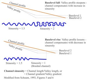
Analysis of modern rivers, plus flume experiments designed to model channel behaviour, indicate a complex response to baselevel change; channels may degrade or aggrade, or they may respond to a change in gradient by increasing or decreasing their sinuosity or channel width. It is also apparent that these re-balancing signals do not project far up valleys; in the case of a small fluctuations in baselevel, the changes in channel morphology may be confined to the coastal plain. Variables that influence changes in channel morphology include (from Schumm, 1993; Ethridge et al, 2005):


Two examples from Schuum’s model of channel modification caused by baselevel fluctuations. In both cases, the changes to river profiles extend only partway up channels and their valleys.
- The rate of baselevel change, for example long-term changes from hinterland uplift or basin subsidence, compared with rapid sea level changes during glaciations;
- The direction of change (baselevel falls tend to produce greater channel responses than baselevel rises;
- The magnitude and duration of baselevel change;
- Local geomorphology (landforms, relief, elevation);
- Channel morphology; width, sinuosity, and the ability of a channel to change – broad valleys provide space for potential changes to channel sinuosity – narrow valleys do not;
- Bedrock geology such as the erodability of the substrate, and structural controls;
- Changes in climate and surface runoff during baselevel changes
A fall in baselevel will expose the continental shelf such that delivery of sediment by rivers will move basinward. If baselevel falls below the shelf-slope break, the relatively abrupt increase in gradient will cause erosion of gullies; at this stage most of the sediment carried by rivers will bypass the shelf, with delivery to the basin beyond. Channels that form on an exposed shelf will be guided by antecedent bathymetric lows, some of which may have developed during earlier cycles of baselevel fluctuation.


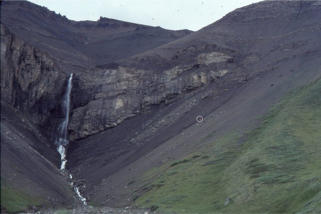
Shelfbreak gullies can form when sea level falls below the shelfbreak. This example is from the Jurassic of Bowser Basin, northern British Columbia. The gully was filled with conglomerate. It is overlain by cyclic shelf deposits. Person (circled) for scale, centre right.
Other posts in this series on stratigraphy and sequence stratigraphy
Stratigraphic surfaces in outcrop – baselevel fall
Stratigraphic surfaces in outcrop – baselevel rise
A timeline of stratigraphic principles; 15th to 18th C
A timeline of stratigraphic principles; 19th C to 1950
A timeline of stratigraphic principles; 1950-1977
Sediment accommodation and supply
Autogenic or allogenic dynamics in stratigraphy?
Stratigraphic cycles: What are they?
Sequence stratigraphic surfaces
Shorelines and shoreline trajectories
Stratigraphic trends and stacking patterns
Stratigraphic condensation – condensed sections
Depositional systems and systems tracts
Which sequence stratigraphic model is that?
Beach microcosms as analogues for fan deltas
References
W.M.Davis, 1902. Baselevel, Grade and Peneplain. Journal of Geology, v. 10. Click on the PDF link to download
F.G. Ethridge, D. Germanoski, S.A. Schuum, and L.J.Wood. 2005. The morphological and stratigraphical effects of base-level change: A review of experimental studies. International Association of Sedimentologists, Special Publication, v. 35, p. 213-241.
L.B. Leopold, and W.B. Bull, 1979. Base Level, Aggradation, and Grade. Proceedings of the American Philosophical Society, v. 123, p. 168-202.
J.W. Powell, 1875. Exploration of the Colorado River of the West: Explored in 1869, 1870, 1871, and 1872, under the direction of the Secretary of the Smithsonian Institution. Washington, U.S. Government Printing Office. The link will take you to a digital version of Powell’s 1875 monograph, created as part of the 150th Anniversary of his 1869 expedition
B.D. Ricketts and C.E. Evenchick, 1999. Shelfbreak gullies; Products of sea-level lowstand and sediment failure: Examples from Bowser Basin, northern British Columbia. Journal of Sedimentary Research, v. 69, p. 1232-1240. Available for download
S.A. Schumm, 1993. River response to baselevel change: Implications for sequence stratigraphy. Journal of Geology, v. 101, p. 279-294.
