Please note – I no longer maintain Glossaries by alphabet; A, B, C… etc. All items on these pages have been moved to subject-specific glossaries such as Volcanology, Sedimentary facies and processes, and so on. The list of subject-based glossaries can be viewed in the drop-down menu on the navigation bar. These glossaries are continually updated.

Earthquake focus: The actual point beneath the surface where an earthquake is focussed. Cf epicentre.
Earthquake magnitude: Magnitude (M) reflects the severity of ground roll and shaking, and on seismograms the amplitude of the signal (usually of surface waves). M is expressed as a number (M1.8, M4.6, M7.8) up to a maximum of 10. The scale is logarithmic, such that a magnitude of 4 (104) is 100 times smaller and less energetic than M6 (106).
Ebb tide: The outgoing tide. Cf. flood tide
Ebb tidal delta: Delta-like platforms that accumulate at the seaward limit of tidal channels that drain harbours, bays and lagoons. Strong ebb tidal currents carry sand from the embayment; sand is also derived from the adjacent beach, shoreface and shelf. The delta platform is modified by transverse waves. Part of the platform may be exposed at low tide. Cf. Flood tidal deltas.
Eccentricity: One of the Milankovitch orbital cycles. Earth’s orbit around the sun is an ellipse where the degree of ellipticity (the length of the ellipse axes) changes about 5% over 100,000 years. Both Precession and Obliquity are superimposed on this longer-term cycle.
Ecliptic (astronomy): The plane in which Earth orbits the Sun. The name derives from the fact that any eclipse can only occur when the Moon also enters the same plane (the Moon’s orbit of Earth is slightly oblique to the ecliptic). See Milankovitch, precession, obliquity, eccentricity.
Edgewise conglomerate: Conglomerate composed of platy or bladed clasts, such as shale fragments, ripped-up carbonate hardground slabs, or shells that are stacked on edge and packed into crude radial patterns. Their formation requires relatively high energy (as well as an abundant supply of clasts). They tend to form on wave-washed beaches and can extend laterally as pavements for many metres.
Ediacaran fauna: Seemingly, the beginning of life forms 575-542 million years ago, that were more complex than procaryotic algae and cyanobacteria of the preceding 3 billion years. They appeared immediately prior to the Cambrian explosion. Iconic fossil forms include fossils that are petal-, feather-, or sea-pen-like. All were soft-bodied.
Effusive eruption: A non-explosive eruption where magma issues from a vent as a lava flow. The VEI score is zero.
Elastic behaviour: This rheological behaviour describes materials that respond to stress by deforming but can return to their original state when the stress is removed. The principle was developed by Robert Hooke– Hookes Law (1660); the classic physics experiment involves a spring. The principle can also be applied to most sediments and rocks. The level of stress at which deformation becomes irreversible is called the elastic limit. Beyond the elastic limit deformation will occur as brittle failure or ductile flow.
Elevation head: see hydraulic head
Elutriation: Removal of fine particles by the upward flow of fluid or gas, through the body of a pyroclastic density current or sediment gravity flow. Elutriation is responsible for the development of a buoyant plume above such flows.
Endemic taxa: Species restricted to certain geographic or oceanic regions, or specific sedimentary basins. Cf. Cosmopolitan taxa.
Endogenic lava dome: Domes that expand as viscous magma is intruded into the dome interior (i.e., they inflate from within).
Endolithic algae: Eukaryotic algae that live in micropores of skeletons and shelly material, and in pore throats of granular sediment. They are capable of dissolving calcium carbonate and promoting early diagenesis or weakening organic structures that leads to their fragmentation. They also play a role in micritisation of bioclasts. The term also applies to endolithic fungi and bacteria.
Endorheic lake: A water body that has no surface outflow drainage, and it surrounded by drainage divides. In most cases inflow from surface runoff and groundwater discharge is balanced or exceeded by evaporation.
En echelon folds: Anticline-syncline pairs that in an ideal system will be about 45o to the PDZ. Fold axes parallel the long axis of the strain ellipse – the axis of maximum extension, and bisect the angle between Riedel and conjugate Riedel shears. Fold axes will also be at right angles to extensional normal faults.
Entablature jointing: Lava cooling joints that form a range of patterns, from irregular accumulations to spectacular radial clusters. Thick lava flows may contain both a lower band of colonnade joints overlain by entablature joints.
Epicenter: The projection of an earthquake focus (at depth) to the surface.
Epiclastic: Sedimentary clasts formed from pre-existing rocks; this applies to most siliciclastic rocks and to many redeposited volcaniclastic sediments.
Episodic tremor: Swarms of very low magnitude earthquakes at a subduction interface and its associated faults, barely felt, if at all. None of the displacements results in major earthquakes. Associated with slow slip displacements.
Epitaxial overgrowth: Cement overgrowths that are not in optical continuity with the substrate grain, and have a different mineral composition. Cf. syntaxial overgrowth.
Equilibrium constant: For a specific reaction, equilibrium constants are the ratio of product activities (or concentrations) divided by reactant activities; they can be determined experimentally (assuming a reaction is at equilibrium) or using thermodynamic considerations (where activities must be used). The general expression for a reaction involving ionic species in solution is: aA + bB ↔ cC + dD, where a, b, c, and d are the stochiometric values for each ion (e.g. 2H+).
K = cC + dD/ aA + bB at equilibrium.
In a real aqueous solution, we can determine whether a reaction will proceed to the left or right: if cC + dD/ aA + bB is <K the reactants will convert to products (the reaction goes to the right. The opposite occurs if cC + dD/ aA + bB >K.
K is strongly dependent on temperature and pressure.
Equipotential: In hydrogeology, a line or plane of equal hydraulic head on a potentiometric surface, or on a hydrogeological cross-section. Equipotentials are determined primarily from well water level data. Equipotential contours allow interpolation of water levels at any point on the potentiometric surface.
Eruption intensity: The rate at which pyroclastic mass is ejected.
Eruption magnitude: The total volume if rock erupted calculated as the dense-rock equivalent volume. C.f. eruption intensity.
Estuary: An inland arm of the sea that is linked to terrestrial drainage. Estuaries are common in regions where a rise in relative sea level has drowned coastal valleys. Hence, they are part of, and merge into bays, harbours, and lagoons. They are usually protected by barrier islands, spits, and bars. The influence of tides can extend 80-100 km inland although this does not mean the salt wedge extends that far. Saline and brackish conditions have a strong influence on biological activity. Tidal ranges vary from place to place; In the Bay of Fundy tides and tidal bores are as high as 14 m.
Eugeosyncline: See Geosyncline, and Miogeocline.
Euhedral: Refers to crystal forms where the original crystal faces are present. For example, quartz overgrowths that present crystal terminations.
Eukaryotes: A more complex organism than the prokaryotes, having a distinct nucleus that contains DNA, with membranes that also enclose various organelles (organelles are specialized packages within cells, each having a different function). This broad group of organisms includes pretty-well everything except the bacteria and cyanobacteria.
Eustasy: Allen & Allen (2005) define it as “…global sea level measured from a fixed datum, such as the centre of the Earth”. A rise or fall in sea level requires either a change in ocean water volumes, or a change in the size of ocean basins (determined by plate tectonics). Fluctuations in ocean volumes are caused by changes in glacial ice volumes, by steric effects (heating and cooling of water), and over longer geological periods tectonic plate configurations. Note that the relative change in sea levels from eustatic causes is not the same everywhere because of gravitational-isostatic effects.
Evaporative pumping: In arid regions, intense evaporation at the surface creates a hydraulic gradient in shallow subsurface aquifers, inducing lateral groundwater and/or seawater flow to replace lost fluid. Vertical capillary flow through the unsaturated zone (above the watertable) transfers these saline fluids from the aquifer to the surface.
Exogenic lava dome: Domes that grow externally by addition and stacking of lava extrusions.
Exoplanet: A planet not in our solar system that revolves around a star. The first confirmed exoplanet was Pi Mensae c in 1992. As of September 25, 2018, there were 3779 confirmed planets and 2819 solar systems. The most successful methos of detection is transiting that occurs when a planet passes between its star and an observer on (or orbiting) Earth, causing periodic dimming.
Exotic terrane: A term for terranes in general, emphasizing its distinctiveness compared with other terranes or an allochthon. See Terrane, Suspect terrane.
Extension: The application of stress that results in an increase in length or volume of rock, sediment, or fluid. It can occur at the scale of entire continents (rifts) or single crystals and grains.
Extinction: As the microscope stage is rotated, under crossed nicols, either the fast or slow vibration direction of light exiting an anisotropic mineral will be blocked by the upper polarizer – at this point no light is transmitted through polarizer and it appears black – the transmitted light has been extinguished. This alignment occurs four times during one 360o rotation (because the fast and slow rays are perpendicular), and therefore each extinction event is 90o apart.
Extinction angle: The angle at which extinction occurs relative to crystal habit or prominent cleavage, may vary between 0o and 89o. The angle can be easily measured using the grid on the rotating stage. Extinction angles can be used to help identify minerals.
- Parallel extinction: Extinction parallel to the crystal elongation direction or cleavage, that also parallels the crystallographic c axis. A common example is muscovite
- Inclined extinction: The most common type, between 0o and 89o.
- Symmetrical extinction: In minerals that have two prominent cleavage planes (such as calcite) – if the extinction angles measured from each cleavage are the same, then extinction is symmetrical.

Fabric: A textural property of rocks that emphasizes clast or crystal orientation or alignment that, in sedimentology can be related to the hydraulics of sediment transport and deposition, in volcanic rocks to lava flow, and in deformed or metamorphic rocks to stress fields.
Facies: Sedimentary facies are descriptions that encapsulate the essential physical, biological, and chemical attributes of rocks and sediments, at whatever scale an observer chooses (e.g. single beds, or groups of beds); facies reflect the conditions in which they formed. Amanz Gressly (1836) originally defined facies to reflect objective descriptions; this purpose is still regarded as important. However, modern usage commonly adds a genetic reference, such as tidal flat facies. Experience shows that many facies repeat through geological time. This is an important attribute because it provides us with a sound basis for interpretating sedimentary rocks and ancient environments. See Facies associations; Facies models.
Facies association: Sedimentary facies that occur together, forming associations that are repeated in time and place (e.g. different sedimentary basins). For example, facies that describe fluvial overbank deposits will be associated with facies that define fluvial channels, swamps, peat bogs, paleosols, and oxbow lakes. It is these associations that provide the real clues to interpreting paleoenvironments.
Facies models: Facies models are simplified descriptions of a complex sedimentary universe, a scaled-down version of a depositional systems like submarine fans, or high sinuosity fluvial channels. They contain facies and facies associations visualised in the context of a theoretical framework of processes. Models allow us to visualise and interpret our observations within an established framework – that framework may be mathematical, conceptual, or empirical. Models allow us to predict outcomes where direct observations or measurements are not possible.
Fairweather wave base: The maximum depth at which wave orbitals impinge the sea floor and sustain sediment movement, during normal fair weather. The actual depth is about half the wavelength. Cf. Storm wavebase.
Fall-back breccia: Debris ejected by a meteorite impact that falls back into and around the impact crater. The breccia consists of bedrock in various stages of melt, including glass. Fall back breccias are observed in many Lunar craters. One of the best ancient examples is the Onapping breccia associated with the 1.85 Ga. Sudbury impact.
Falling Stage Systems Tract (FSST): Forms during relative sea level fall when sedimentation rates are low. The FSST is bound at the base the basal surface of forced regression; at the top by a subaerial unconformity and its correlative conformity. Depositional systems include the shoreface and deeper shelf, and base of slope.
Fan delta: Fan deltas are like alluvial fans except they dip their toes in lakes and shallow seas. So, in addition to the alluvial component, there is subaqueous deposition down a relatively steep, angle-of-repose slope. Large, basinward-dipping foresets are a defining characteristic. They are generally coarse-grained. Fluvial distributary systems tend to be braided.
Fascicular optic calcite: Void filling cement that consists of radially fibrous calcite clusters, where the crystal optic axes diverge towards the centre of the void. in concert with diverging crystals. Cf. Radiaxial fibrous cement.
Fault-bend folds: Folds that develop in the hanging wall where there is a change in the inclination of a fault plane. For thrust ramps, this includes a syncline above the flat-ramp transition, and anticline at the fault tip, thus producing a characteristic anticline-syncline pair. Compare this category of folds with those produced by fault propagation.
Fault breccia: Angular blocks of bedrock produced by crushing and grinding during faulting. A distinction is sometimes made between a breccia made up of clasts >1 mm and <0.5 m, and megabreccia with clasts >0.5 m. An important difference among fault breccia, gouge, and cataclastite is the high degree of induration in the latter. Cf. cataclastite, gouge.
Fault conduit: The open, dilational part of a fault between fracture planes. Conduit width, or aperture, is measured normal to fracture surfaces. The width can vary considerably along the length of a fault. Fault conduits provide access for fluid flow.
Fault core: In hydrogeology, this is the primary zone along the fault plane, and can be presented as an open conduit, a zone of fractured rock and gouge, or a zone of mud-shale lithologies that have been smeared along the fault plane during fault shear. The permeability of the core will depend on the relative proportions of these attributes.
Fault damage zone: The zone either side of the fault plane or fault core that where the host rock is damaged by fracturing and cataclasis. The degree of damage decreases with increasing distance from the core. The intensity of deformation depends primarily on the magnitude of fault displacement.
Fault gouge: Very fine ground-up rock along a fault plane of fault zone. Gouge materials are generally <0.1 mm. Cf. fault breccia, cataclastite.
Fault heave & throw: Heave is the horizontal displacement produced by a fault; throw is the vertical displacement. Both are components of actual slip. They are measured from hanging wall and foot wall cut-offs.
Fault permeability: The permeability along the plane of the fault, primarily through the fault conduit and damage zone, and normal to a fault plane. Faults in this context provide a focus or barrier to fluid flow.
Fault plane: A plane across which rocks are displaced. In map view fault planes are projected as traces that are straight or arcuate; in 3D they are flat or curved, the latter usually concave upward (listric faults).
Fault propagation folds: Folding caused by the distribution of strain beyond a fault tip, as the thrust fault propagates. This mechanism also produces anticline-syncline pairs. A nice example from the tip of Lewis Thrust, Alberta Front Ranges, is shown below. The isoclinal fold pair in the header image (top of page) are also fault propagation folds.
Fault recurrence interval: The probability of earthquake activity along a fault, based on historical, archeological, and geological records. These assessments are dogged for known active faults by the relatively small number of recorded events.
Fault scarp: The topographic expression of a fault plane. Most scarps become degraded relatively rapidly by collapse and erosion of the uplifted block, particularly in weakly consolidated rock, sediment, or soil. These processes tend to remove direct evidence of fault slip. Trenching profiles across the fault trace is a valuable method for recovering some of this data.
Fault separation: A term used to describe the apparent displacement of fault blocks, strata, or marker units when true slip cannot be determined, or when the fault plane is not exposed.
Fault slip: The actual displacement of blocks across a fault plane. There are three basic types: dip-slip (fault blocks move up or down), strike-slip (fault blocks move laterally), and oblique-slip (components of dip- and strike-slip). Slip is indicated by fault plane structures such as slickenlines, drag folds, and tension gashes. If true slip cannot be determined, then displacement is described as apparent.
Fault splay: A single fault strand divided into two or more faults such that displacement is distributed across the new structures.
Fault trace: The surface, or map projection of a fault plane. On a map, the relative displacement is indicated by arrows or up/down (U/D) symbols.
Fault zone: Faulting that is distributed across a zone of broken rock and/or several closely spaced faults. The width of fault zones ranges from a few centimetres to many 10s of metres. Fault zones are common in weak rock and unconsolidated sediment. Crushing and grinding of rock produces fault gouge, cataclastite, and fault breccia.
Feldspar: The most abundant mineral in Earth’s crust. It is present in nearly every kind of igneous rock; it is also a common hydrothermal product. In sedimentary rocks it occurs as a common detrital component, and as an authigenic phase (usually albite). Feldspar is a sheet silicate comprising two main groups: the Alkali feldspar group – most common are potassium-bearing feldspars (K-spar) that forms a solid solution series with Albite; and the Plagioclase group that form a solid solution series from Albite (sodium end member) to Anorthite (Calcium end member). All feldspars have good cleavage. There are several types of twinning, for example the common perthite and Gridiron twinning of K-spars, and albite, carlsbad, pericline twins in plagioclases.
Feldspar laths: Microscopic, needle-like crystals of feldspar, usually plagioclase, in a glassy groundmass. Alignment of laths provides an indication of flow. These textures commonly develop in rapidly cooled basalt lavas.
Felsic: A contraction of ‘feldspar and silica’, that describes in very general terms igneous and metamorphic rocks that are rich in silica and minerals containing lighter alkali metals like sodium and potassium. For igneous rocks this includes rhyolites, dacites, and granites. Cf. Basic igneous rocks.
Ferric (iron): Fe3+, or Iron III. is the common oxidized state of iron. It is the primary form of iron in limonite (FeO(OH)·nH2O) and hematite (Fe2O3). Magnetite (Fe2+ Fe3+2 O3 contains both iron II and iron 111. The oxidised state produces the red colouration in red beds and red shales.
Ferrous (iron): Fe2+, or Iron II. This is the common reduced state of iron in aqueous solution and common minerals like siderite (FeCO3), iron sulphate (FeSO42-), iron sulphide (FeS), and pyrite (FeS2). It combines with iron III in magnetite, and substitutes for calcium (Ca2+) in ferroan calcite, and for magnesium in ferroan dolomite. Iron II is largely responsible for the greenish hues of reduced shales.
Fiamme: Lenticular, lozenge-shaped to wispy fragments of glassy and pumiceous tephra that are common in hot pyroclastic flows, and are stretched while in a viscous state. Lengths range up to a few centimetres. The plane of flattening approximates bedding.
Fireball: A large meteor that begins to burn up on entering the atmosphere. Brightness is > -4, which is about the brightness of Venus. It is usually visible for a few seconds.
Firn: Snow that is at least one season old and has undergone some compaction. It is much less dense than glacier ice, but more dense than névé. Firn transforms to glacier ice during subsequent burial.
Fission tracks: Fission track technology allows us to unravel the thermal history of sedimentary basins. Certain minerals like apatite contain small amounts of Uranium-238. Uranium decay produces a visible track, a few microns long, where the apatite crystal structure has been damaged by radiation. If we can measure the amount of uranium present, and knowing the half-life of uranium-238, we can determine the age of the crystal by counting the number of tracks. Fission tracks are annealed at temperatures >110oC, for example during sediment burial. If the rock is then cooled below 110oC fission tracks will again begin to develop. Thus, the age of cooling below 110oC can also be determined.
Flame structures: Whispy, flame-like mudstone structures that form during early, differential compaction of sandstone-mudstone interbeds. The flames appear to protrude from the mudstone into the overlying sand. https://www.geological-digressions.com/sedimentary-structures-turbidites/
Flaser bedding: Sandy deposits in which ripples are draped by muddy veneers, or flasers. They are common across mixed sand-mud tidal flats. The ripples form during one stage of tidal flow; the mud drapes during the opposite flow. They commonly occur with lenticular bedded ripples. Together they provide good evidence for tidal current asymmetry.
Flatiron: A geomorphic term for a relatively planar, steeply dipping bedrock slope (a dip slope) that tapers from its base to a narrow pointy top. Hogbacks may contain several flatiron slopes.
Flexural wave: Flexure of oceanic and continental lithosphere produces a foredeep, an adjacent forebulge and a shallow back-bulge basin. Together, the three components are wave-like, having amplitude and wavelength that depend on the properties of the lithosphere. Wavelengths are commonly measured in 100s of kilometres; amplitudes up to 8 km.
Flexure: The mechanical response to loading an elastic plate. In a plate tectonic context it can occur in oceanic and continental lithosphere. The amount of flexure depends on the elastic thickness and strength of the lithosphere. Flexure is responsible for creating sedimentary basins at plate margins, such as oceanic trenches at subduction zones, moats around large volcanic edifices, and foreland basins at collisional margins.
Floatstone: More than 10% allochems coarser than 2 mm (upper limit of coarse sand), supported by grains finer than 2 mm.
Dunham’s (1962) limestone classification scheme reviewed and modified by Lockier and Junaibib (2016).
Flood tidal delta: A delta-like platform that accumulates on the inward part of tidal channels at the entrance to harbours, bays and lagoons. Strong flood tidal currents carry sand from the beach, shoreface, and shelf and channels that drain the embayment. Cf. Ebb tidal delta.
Flow banding (volcanic): Banding that is concentric, or intricately folded is common in rhyolite and dacite domes; each band represents a slightly different texture and/or mineral composition and develops during the slow movement of highly viscous magma. Intricate folding can also occur, particularly around magma fragment. This folding is NOT tectonic. Flow banding can also occur in hot pyroclastic ash flows, where temperatures are high enough to render ash fragments fully ductile.
Flow net: A 2D cross-section or 3D model of equipotential lines or planes that describe aquifers and their associated aquitards. It is basically a representation of hydraulic potential. Flow lines can be constructed based on assessed hydraulic gradients, to show the directions of groundwater flow.
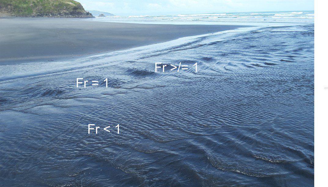
Flow regime: A useful model for deciphering the hydraulic conditions of deposition and bedforms for unidirectional flow, introduced by Harms and Fahnstock, 1965. The model partitions bedforms according to flow velocity and the configuration of surface waves. There are two fundamental types of flow:
- Lower Flow Regime – at the lowest flows laminated sand, and with increasing velocity, a transition from ripples to larger dune bedforms. For the latter, the surface waves are out of phase with the bedforms.
- Upper Flow regime – includes parallel laminated sand (the type that produces parting lineations), and at higher velocities, antidunes (where the surface waves, or standing waves are in-phase with the bedforms), and chute and pool. A hydraulic jump forms when Upper Flow weakens to Lower Flow regime.
Flow unit: A term that applies equally to sediment gravity flows (like turbidites, debris flows) and pyroclastic density currents. It refers to a stratigraphic unit, bed or layer deposited during a single flow event. Pyroclastic flows like ignimbrites and surges may contain many flow units.
Flower structures: Characteristic fault splays that develop at restraining and releasing bends, and at stepovers of strike-slip faults. Strain is concentrated at these locations along the fault plane so that movement along the main fault is transferred to a secondary fault; this process can be repeated several times, producing fault splays that in 3-dimensions, merge with the master fault. These splays are also called strike-slip duplexes. Flower structure refers to the cross-sectional view of duplexes. In positive flower structures (also called palm tree structures), the displacement is predominantly reverse (transpressional); in transtensional environments the displacement is normal dip slip in cross-section – these are negative flower structures or tulip structures. However, the sense of displacement can change up fault plane dip and along strike.
Fluid inclusions: Microscopic bubbles trapped in a crystal as it precipitates, contain samples of the fluid from which the minerals were originally derived. The fluid occurs as a single phase – liquid or vapour, or two phases with both liquid and gas. Most inclusions are less than 100µm (0.1mm) long. The fluids within may be fresh water or brines, or hydrocarbons. Samples are usually viewed in thin sections, gradually heated until the liquid and vapour homogenize into a single phase. The homogenisation temperature is generally considered to be the temperature at which the mineral crystal formed.
Fluid pressure: The pressure within a fluid (liquid and gas phases), usually expressed as a compressive stress – in its simplest form: P = ρgz
where P is the pressure of interstitial fluids at some depth measured vertically, ρ is the density of the fluid, g = the gravitation constant, and z the depth from the surface to the point of interest. Fluid pressures generally increase with depth in the crust. Cf. hydrostatic pressure, lithostatic pressure.
Fluidization: The process where sedimentary particles are suspended, or float in the interstitial fluid by the upward flow of fluid. In contrast, the fluid in a liquefied sediment is largely static. Fluidization in sediment may be caused by escaping, overpressured fluids (dewatering).
Flute casts: Tapered, scoop-shaped scours on sediment surfaces that are subsequently filled with sediment and exposed as casts at the base of the overlying bed. The tapered end points in the direction of flow, or paleoflow; flute casts provide unambiguous paleocurrent directions. The original scour may have been initiated by turbulent eddies, or erosion down-flow of small objects like pebbles, mud rip-ups, and fossils. They are common at the base of turbidites, and frequently accompany other sole marks like groove casts and skip marks.
Flux melting: A term derived from welding and glass making. A flux is a substance that lowers the melting point of solids. It applies to magma generation in the mantle where water, derived by dehydration of mica, glaucophane, and serpentinite minerals, lowers melting points by 200°C and more. Flux melting is a critical stage in the formation of partial melts.
Fold axis: An imaginary straight hinge line in cylindrical folds. If the fold axis is moved parallel to itself it will recreate the fold; this condition does not hold for hinge lines. A fold axis must lie on the axial plane.
Fold-thrust belt: A major thrust system developed during lithosphere-scale plate convergence, with cumulative shortening of 100s of kilometres, that usually results in mountain building. The resulting topographic results in flexure and formation of a foreland basin. Thrust faults are generated in pre-existing strata, but usually evolve to include the proximal parts of the foreland basin and its sediments. An example is shown below.
Fondoform: A term introduced by John Rich (1951) to encompass the region between the base of a slope (continental, delta) and the deep basin beyond. Fonoform was part of his system that included clinoform and undaform. The terms undaform and fondoform have all but faded into obscurity.
Foraminifera: A large group of single-celled marine protists that secrete chambered tests (shells), each chamber being added as the organism grows. They range from about 100 microns to several centimetres. Depending on the species, secreted tests consist of a chitinous material (organic), agglutinated sand grains, calcite or aragonite. Of about 4000 living species, 40 are planktic, the remainder are benthic. Their biostratigraphic range is Cambrian to Recent. They are one of the most important groups of microfossils in biostratigraphy and paleoecology.
Forced regression: Forced regression occurs during fall in baselevel (sea level) if the rate of fall (the rate of change of negative accommodation) exceeds sedimentation. In this case, shorelines and associated shallow marine deposits are forced seawards; the shoreline trajectory is also down depositional dip. Cf. Normal regression.
Forearc basin: Basins in the upper plate between the ocean trench and magmatic arc at convergent margins. Subsidence is due to crustal flexure resulting from tectonic loading by an accretionary wedge. The wedge consists of structural slivers of oceanic crust and sediment scraped from the subducting slab. Thrusts usually dip towards the arc. Thrust slivers are added to the bottom of the thrust stack.
Forebulge: A positive, low amplitude uplift outboard of the foredeep, that is a flexural response to loading of an elastic plate. Also called a peripheral bulge. It forms the outer limit to the foredeep. Deposits over the bulge are thin or condensed; unconformities are common. The bulge migrates in tandem with the topographic (orogenic) load and the foredeep axis.
Foredeep: The component of a foreland basin immediately outboard of the orogenic load (fol-thrust belt); also referred to as a foredeep depozone. It lies between the wedge top and forebulge depozones. The foredeep axis is approximately parallel to the orogenic belt. Sediment is sourced from topography in the orogen.
Foredune: Sand dunes that line ocean, lagoon, estuarine, sandspit and barrier island, and lacustrine coasts. In marine settings they occupy the zone above high or spring tide. They usually contain sand of the same composition as the beach. They form an important part of a budget system that sees sand moved into and out of the dune-beach and adjacent shoreface.
Foreland: The continent side of an orogen that contains a miogeoclinal prism (that thins towards the craton) overlying crystalline basement. In a collisional orogen the older strata are involved in thin-skinned thrusting and tectonic shortening, manifested as a fold-thrust belt and foreland basin. The foreland is separated from the hinterland by a collisional suture zone that commonly contains high pressure metamorphic rocks (e.g. blue schist) and lots of evidence for ductile deformation.
Foreland basins: Basins formed on continental crust as a result of continent-continent or continent-arc collision across a convergent plate boundary. In both cases, basin subsidence is the result of tectonic loading and flexure of continental lithosphere by massive foreland thrust stacks. The foredeep axis tends to migrate away from the thrust-fold belt in concert with developing thrusts, or back towards the thrust-fold belt with erosion of the mountain topography. Foreland basins resulting from continental collision are also called peripheral foreland basins; those associated with magmatic arcs are called retroarc foreland basins.
Foreset: Dipping, closely spaced stratification that define crossbeds. Normally seen in cross-section profile views of bedforms where they represent the lee face of ripples and larger dune structures. Foresets dip in the direction of flow and bedform migration. Foresets develop as grains move from the bedform stoss face and avalanche down the lee face.
Form (textural): A textural term that describes the overall shape of grains such as elongate (rod-like), spheroidal, bladed, platy, and equant (equidimensional).
Formation: A formal lithostratigraphic unit based on rock composition and mapability; it must have well defined and easily identifiable surface or subsurface contacts. Formations boundaries have no chronostratigraphic significance. Formations are inherently diachronous.
Fracture networks: In hydrogeology this refers to the three-dimensional array of joints and faults for which there is interconnected permeability.
Fracture porosity: The pore space permitting fluid flow through rock fractures and joints. Fracture and joint networks are oriented according to ancient stress fields, hence the porosity will also be focused at these orientations. It tends to occur in hard rock. In crystalline or volcanic rock (the latter includes columnar joints) it is the only effective porosity.
Framboid: Small, spherical aggregates of microscopic crystals, commonly measured in diameters of microns to 10s of microns. One of the more common occurrences is pyrite. They can form as primary precipitates in aqueous environments, or as diagenetic products. From the French framboise for strswberry.
Framestone: A limestone composed of in situ frameworks build by organisms (i.e. not transported). Common examples include corals, stromatoporoids, and oysters. The matrix between framework components should be described separately.
This term was introduced by Embry and Klovan (1971) as a modification of Dunham’s (1962) limestone classification scheme; see review and modification by Lockier and Junaibi (2016).
Frost heave: Soil of bedrock that is pushed towards the surface by the expansion of ice as it freezes. Heave can result in general mounding of saturated soils or sediment, or the pushing upward of blocks of rock bound by fractures or joints. This process can create significant damage to building foundations. It is a common periglacial phenomenon.
Froude number: A dimensionless number that expresses the characteristics of flow, including surface waves and bedforms, as the ratio between gravitational forces and inertial forces:
Fr = V/√g.D
Where V is bulk flow velocity that reflects the dominant effect of gravity on surface flows, and the inertial component is √g.D where g is the gravitational constant, and D is water depth. The denominator represents the speed of a surface wave relative to the bulk flow velocity. Whether the surface wave is faster, slower or the same speed as the bulk flow will depend on its resistance to move, or its inertia.
Fumaroles: Also known as Solfataras. Geothermal gas and steam vents where temperatures are >/= 100°C. The proportion of liquid water is low. They tend to form when the watertable is deep. , Hot springs are more common where waterables. are shallow.