

Krakatoa, 1883, and the seas shivered. The eruption, one of the largest in recorded history, delivered tsunamis that swept away entire villages around Indonesia and its neighbours; little more than the flotsam and jetsam of nature’s fickleness. Five years later, in the same general neighbourhood, nature was at it again.
Ritter Island, barely a speck on most maps, is a volcanic edifice rooted to the floor of Bismarck Sea between Papua New Guinea and New Britain. In 1888, most of the island slid beneath the waves, creating avalanches of rocky debris. Eye-witness accounts tell of multiple tsunamis over a 3-hour period, and waves at least 8m high with run-ups to 15m above sea level. Ritter Island is an active volcano, but at that time it was not erupting in any major way. The island landslide is probably the largest in recent history – more than 4 cubic kilometres of volcanic rock were dislodged and redeposited along the seafloor. Slope failures like this are called volcanic sector collapses.
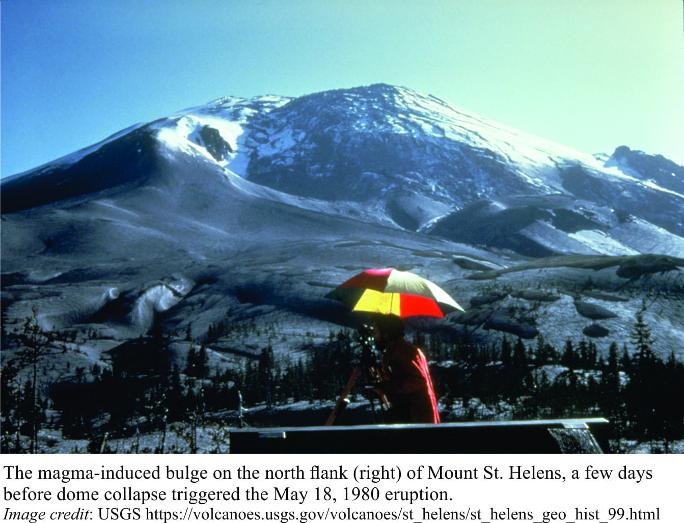
Any steep volcanic edifice has the potential for sector collapse. The 1980 eruption of Mount St. Helens provided one of the first opportunities to directly observe wholesale volcanic slope failure. During the build-up to the main eruption, magma rose into the volcano causing the north flank to bulge by 135m. On May 18th, a moderate earthquake (M5.1) triggered the failure of the magma dome and surrounding flank. A huge debris avalanche careened 23km down the valley opposite. Removal of the dome acted like popping a champagne cork; the immediate pressure release resulted in a lateral (sideways) blast of hot magmatic gasses and debris traveling at speeds up to 480km/hour. The lateral blast was followed by a vertical eruption column that reached altitudes of 24km. But it was the sector collapse of the north flank that set these other processes in motion.
Volcanoes are inherently unstable, by virtue of their steepness, and structural weaknesses caused by hot fluids and magma intrusions. They are also the locus of earthquake swarms in the lead up to, and during eruptions. Thus, all manner of landslides and muddy debris flows, or lahars, can occur at any time during or long after an eruption.
In comparison, wholesale failure of entire mountain flanks is, thankfully, far less common. The mechanisms of failure are not well understood. Does the flank fail as a coherent block that gradually breaks up as it moves, or does the slide break up into an incoherent rubbly mass as soon as it begins to head down slope? At the point of failure, debris of all sizes, including blocks several 100 metres wide, accelerates downslope under the influence of gravity. Any water added to this mix will increase the avalanche mobility. In fact, we know from examination of ancient deposits, that rock avalanches can transform into highly mobile lahars if sufficient water is available.
Sector collapses tend to be large (measured in km3) and upon entering the sea, instantly displace extremely large volumes of water. The impulse from this displacement gives rise to tsunamis. The Ritter Island event showed that many large waves can be produced, with periods of only a few minutes (i.e. the time between successive waves). In contrast, earthquake-produced tsunamis commonly have periods of 60 minutes and longer.
Two basic kinds of evidence help define older sector collapses on oceanic islands: landscapes and subsea profiles that preserve features of slope failure and avalanches, and tsunami deposits at high elevations. Some of the better-known, although in some cases still disputed tsunami deposits that have been attributed to sector collapse, have been described from Hawaii, Tenerife and La Palma in the Canary Islands, and Fogo in the Cape Verdes Islands.
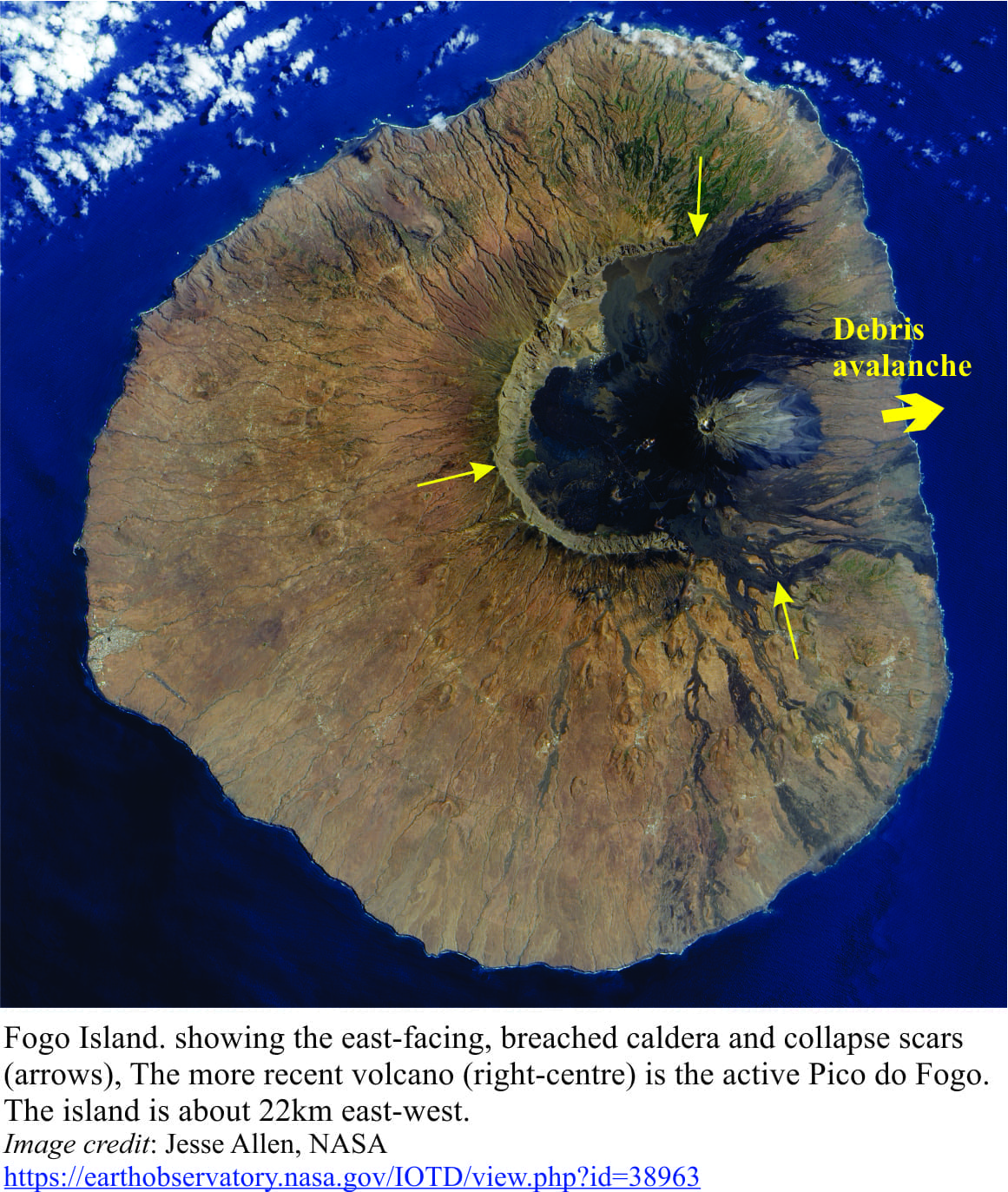
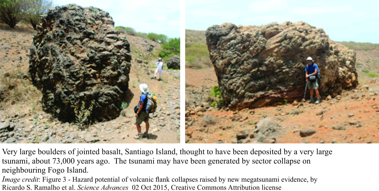
The small volcanic island of Fogo contains a particularly fine example of sector collapse, preserved as a breached caldera. Collapse occurred between 65,000 and 124,000 years ago; the avalanche debris is preserved along a rocky swath of the sea floor directly opposite the caldera. Some 55 km due east is Santiago Island, and it is here that spectacular boulder deposits are found up to 220m above sea level and 650m inland. Boulders up to 8m across, consist mostly of columnar jointed basalt, with some limestone and sedimentary conglomerate; all these rock types are exposed at elevations below the boulders. Dating of the deposits indicates they formed between 65,000 to 84,000 years ago. The mega-boulders are interpreted as having been emplaced by a very large tsunami (megatsunami) with a run-up of at least 270m.
The Canary Islands (off northwest Africa) seem to have had their fair share of large, catastrophic volcano flank failures. Possible tsunami deposits have been recorded at elevations to 132m on Tenerife (Canary Islands).
Here, boulders are mixed with species of coral and various molluscs that normally would not live together (this kind of mixing of disparate faunas is also observed in ancient Hawaiian tsunami deposits). The Tenerife deposits are about 170,000 years old.
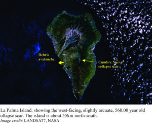
La Palma, about 100 km west of Tenerife, also bares the scars of an ancient sector collapse. The Cumbre Nueva scarp outlines the head of a massive collapse 560,000 years ago, that incorporated about 200 km3 of rock, a volume that dwarfs the Ritter Island and Mt St Helens events. The old avalanche deposits have been mapped across the adjacent sea floor. More recent volcanism is focused along the old scarp.
 It has been hypothesised that this part of La Palma is once again unstable and could slide into the sea, with catastrophic consequences. Published in Geophysical Research Letters (2001), it was suggested that the next block of rock to fall off La Palma could be as large as 500 km3, potentially generating large tsunamis that could reach west Africa, Europe and Britain, and eastern North America. This news was received with alarm (Guardian report in 2004), which noted that the chunk of rock about to collapse into the sea was the size of the Isle of Man. A swarm of small earthquakes in 2017, once again raised the spectre of imminent inundation, as the media vigorously relayed imagined catastrophic scenes on a quaking public.
Some of these fears were allayed, or at least they should have been if the media and public had listened, by landslide expert Dave Petley (University of Sheffield), who noted that several parameters used to develop the 2001 La Palma collapse model were quite extreme, and that changes in any of these would result in much smaller collapse segments, and therefore, much smaller tsunamis. He also noted that very large slope failures tend not to collapse as a coherent block, but in several episodes as the block gradually breaks apart, and that the subsequent tsunamis are likely to be much smaller.
Notwithstanding the media hyperbole, volcanic island sector collapse and subsequent tsunamis are real phenomena, but first-hand observations of these large, energetic events are lacking – for good reason. Geologists and volcanologists, including landslide specialists, will continue to try making sense of ancient examples, while monitoring specific locations that are suspected of potential collapse. I expect La Palma is being watched closely.
Note added a day later: A paper that asks questions about mega boulder deposits, tsunamis, and storm surges, appeared in the Proceedings of the National Academy of Sciences a day after this post was published, that will give greater context to the origin of these interesting, somewhat enigmatic deposits. Unfortunately it sits behind a paywall.
Another note, September 2019. Here’s a very useful August 2019 compilation and downloadable database of oceanic island landslides – 182 in all (dimensions, vertical fall, run out, age), by