Category Archives: Groundwater – geofluids

Mineralogy of evaporites: Death Valley hydrology

Facebooktwitterlinkedininstagram

Death Valley from Dante's View. Death Valley Falt trace runs across the mountain front

The hydrogeology and brine evolution of Death Valley waters

This is part of the How To…series  on evaporites

Death Valley – you have to wonder why anyone would want to spend time there – parched, one of the hottest places on Earth, salty, life in a precarious balance. But like all deserts, quite beautiful.   Extremes like these often appear other-worldly – perhaps that’s the attraction.

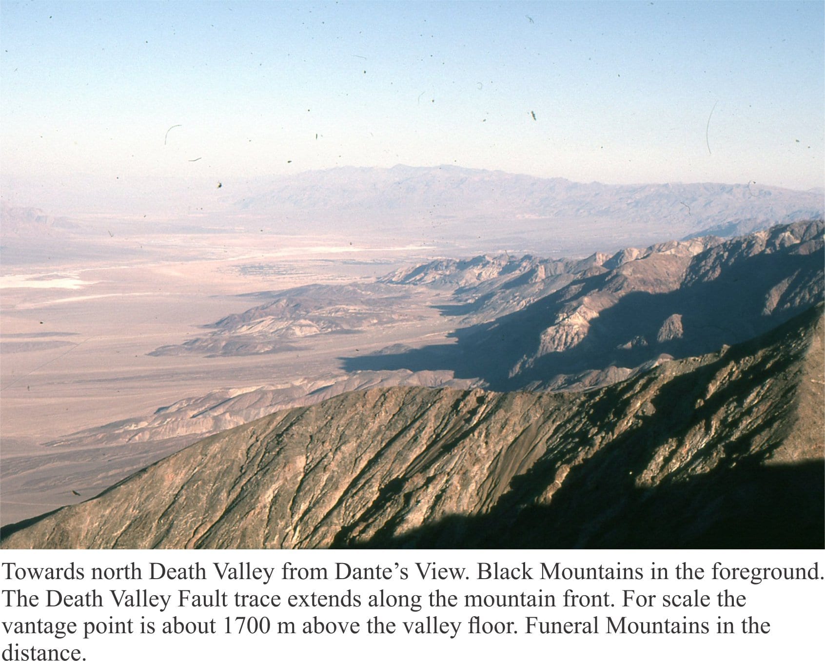
Death Valley is a pull-apart basin, bound on its eastern margin by the right-lateral strike slip Death Valley and Furnace Creek faults. Deformation of the basin has continued for the last 6 million years. The faults are considered to be active, with recurrence intervals of about 1000 to 2000 years. The basin is part of the Basin and Range Province that is presently undergoing lithospheric-scale extension. Slip along the Death Valley Fault System accommodates some of the strain generated at the transcurrent Pacific Plate – North American Plate boundary (Del Pardo et al. 2012).

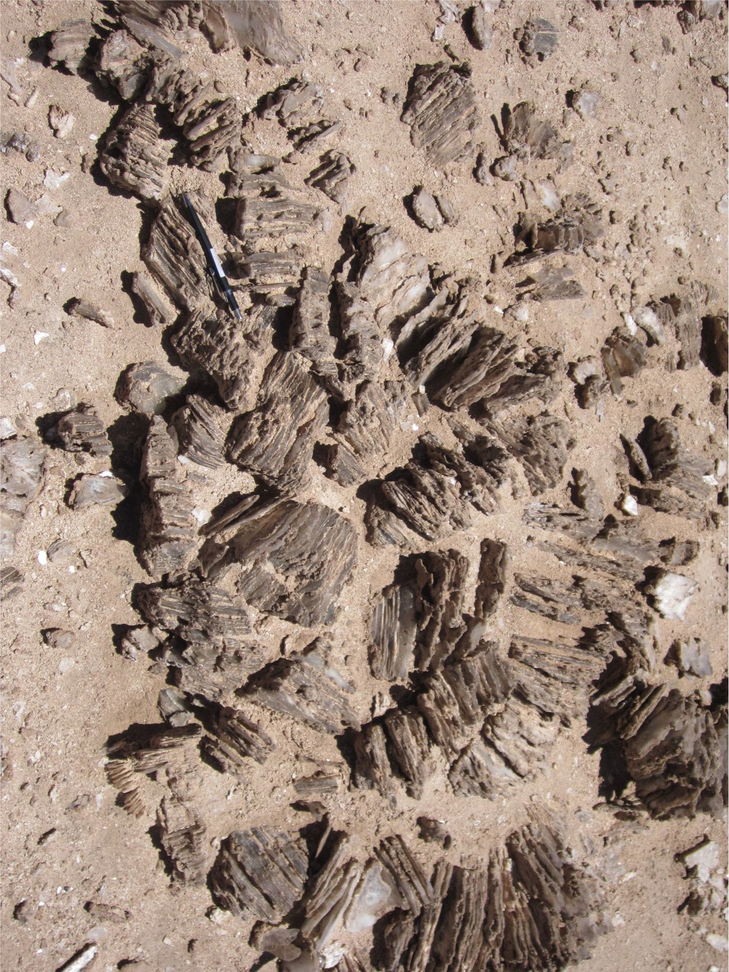
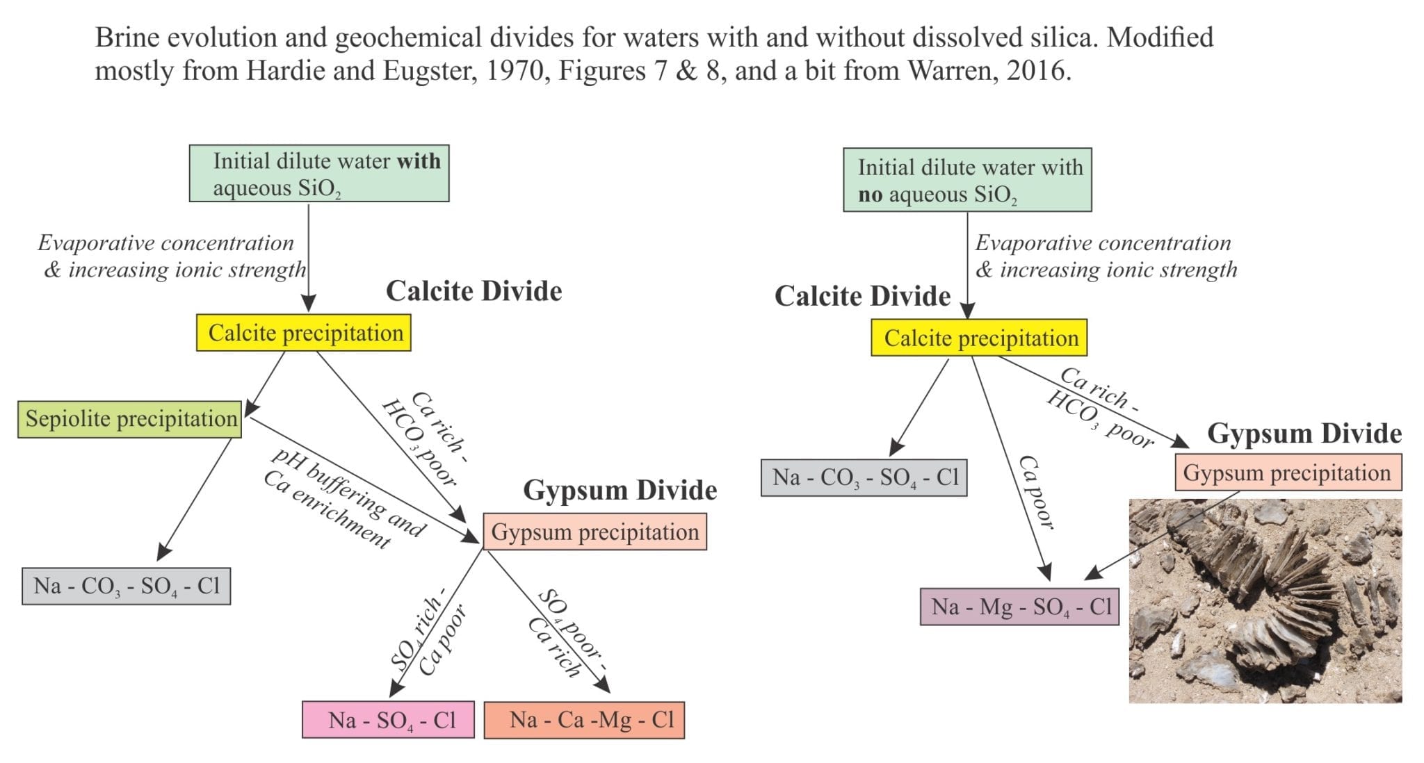
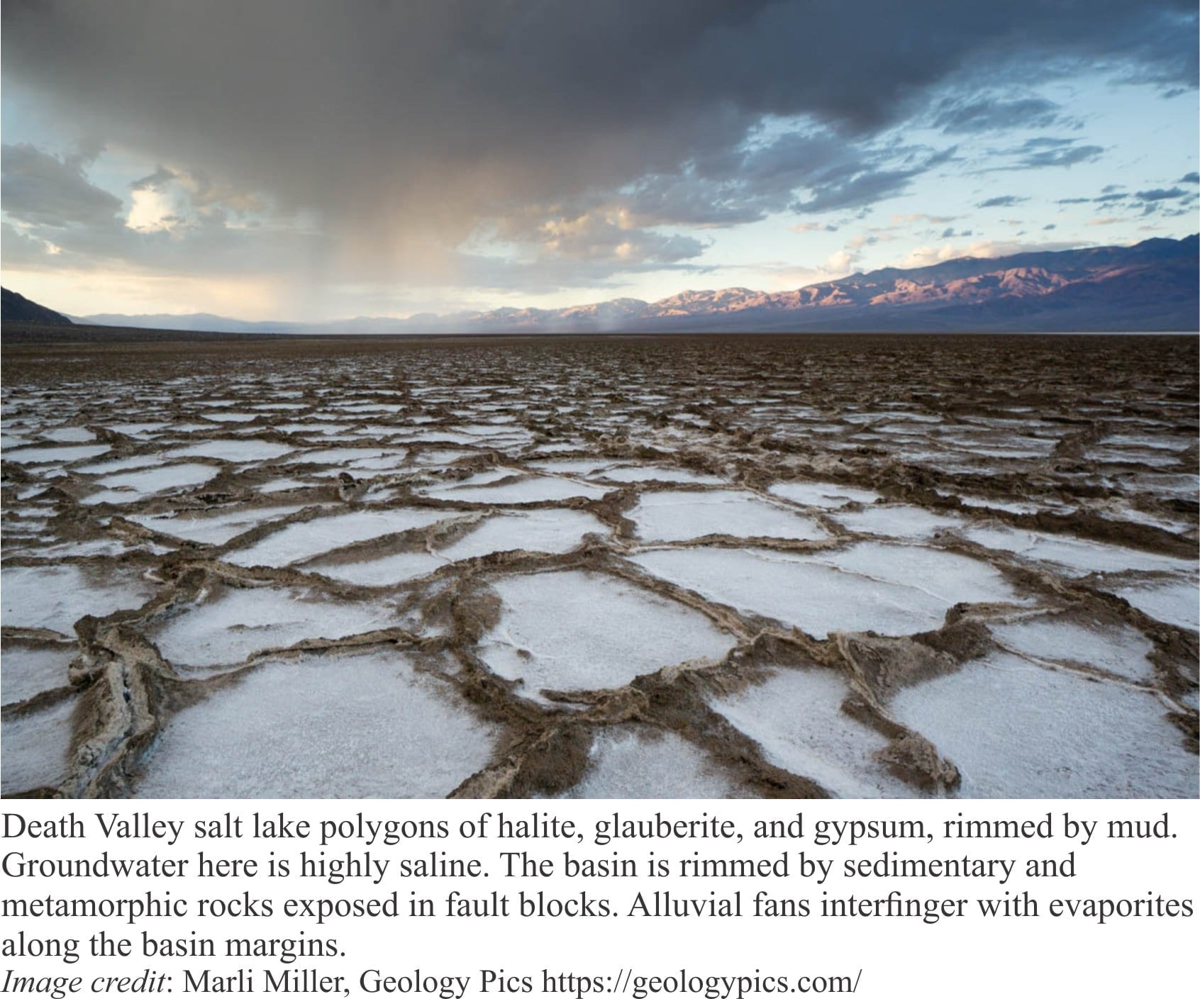
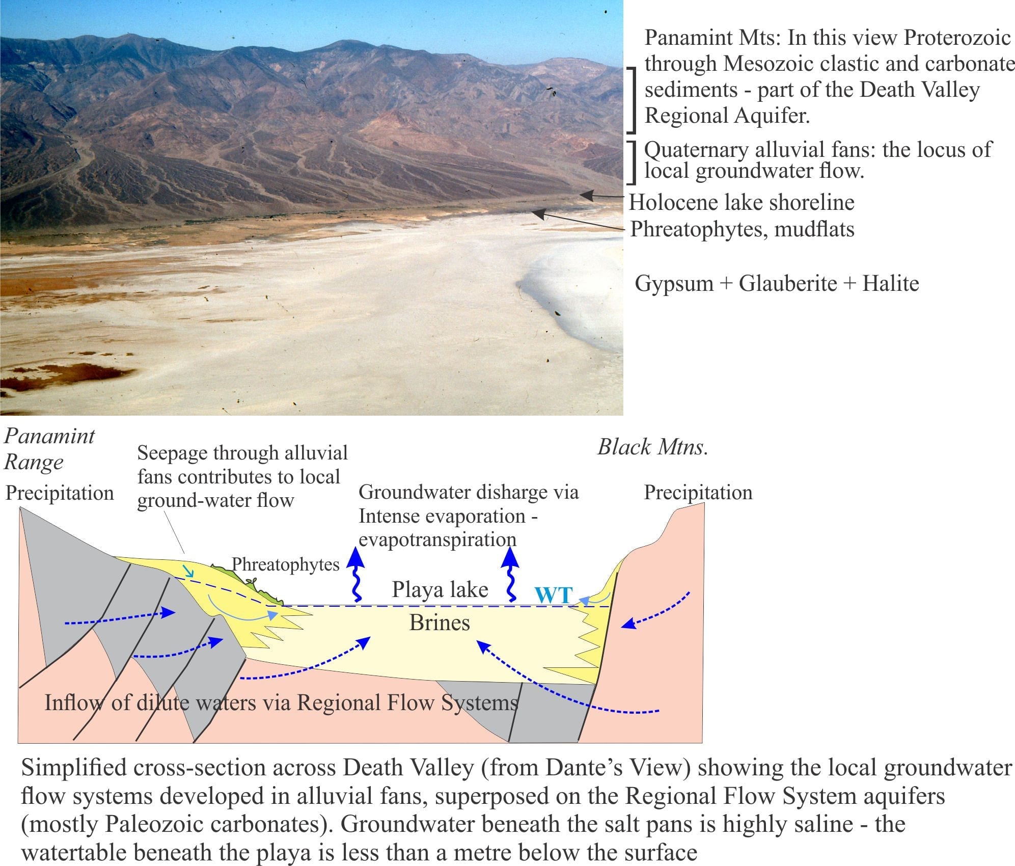
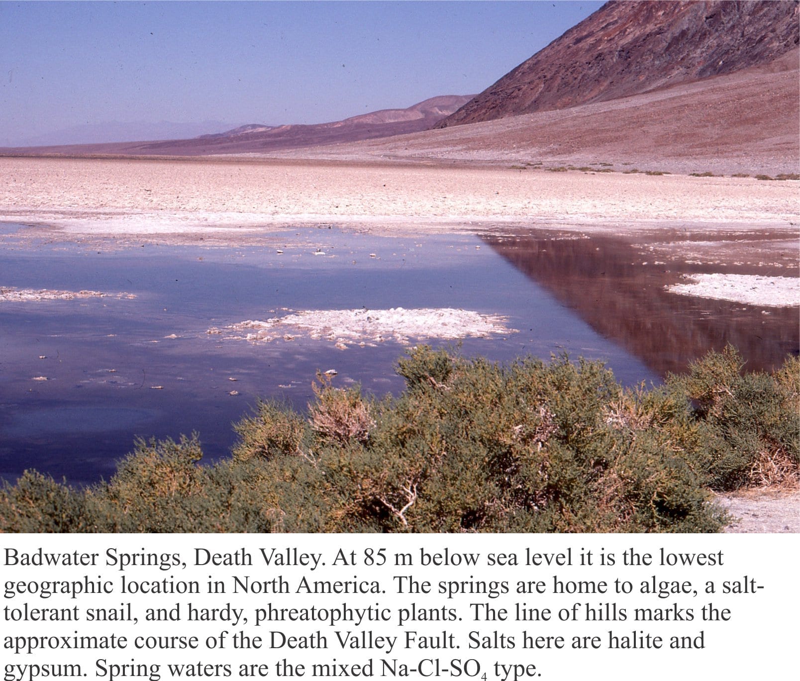
Death Valley playa lake is floored by desiccated mudflats and salt pans, the latter characterised by gypsum, halite, and glauberite. Summer maximum temperatures average 43o – 46oC but can be as high as 56oC at the aptly named Furnace Creek; winter temperatures are definitely cooler, and at high elevations are frequently sub-zero. Precipitation at the valley floor averages about 60mm/year. Precipitation increases with altitude in the adjacent ranges. Humidity is as low as 10% in the summer, and as high as 55% in winter. Thus, evaporation is intense and there is a significant deficit between water inflow and discharge.

Groundwater beneath the playa (< 1 m) is saline. However, like most saline lakes, Death Valley brines originate from dilute waters. The composition of dilute waters, whether delivered as surface runoff or groundwater, is strongly dependent on the bedrock and soil chemistry through which they flow, and in the case of groundwater the residence time for flow. Death Valley waters are interesting because three different chemical groups have been identified, depending on their association with bedrock types (Li et al. 1997; Lowenstein and Risacher, 2007):

  1. Na-HCO3-SO4 spring and seepage inflows that are relatively widespread in the northern and southern basins of the playa,
  2. Ca-Cl inflow from springs in a relatively restricted area south of Badwater, and
  3. Mixtures of types 1 and 2.

Death Valley water brine chemistry ternary plots showing the evolutionary trends of of surface brines

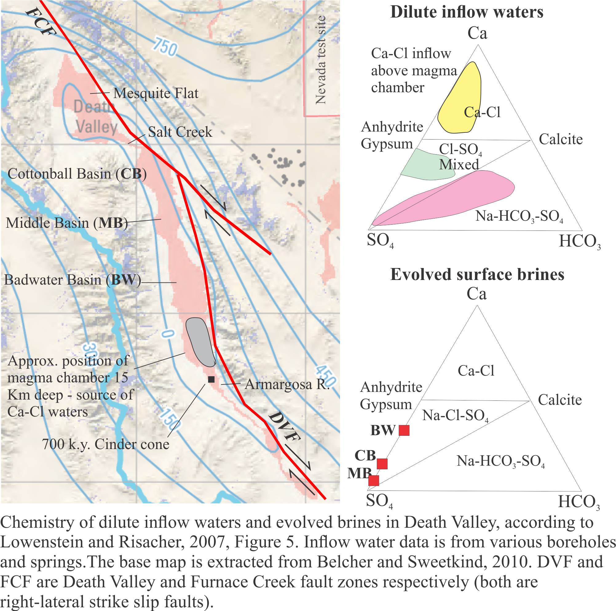
Brines produced by evaporation tend to plot in the Na-Cl-SO4 field on a Ca-SO4-HCO3 ternary diagram. According to the modelling done by Lowenstein and Risacher, brines having this composition are possible from mixing of Ca-Cl and Na-HCO3-SO4 waters. There are no pure Ca-Cl brines in Death Valley, indicating all the original Ca-Cl inflow waters are mixed.

Common salts in Badwater Basin include:

  • Halite (NaCl)
  • Gypsum (CaSO4)
  • Glauberite (CaSO4. Na2SO4)
  • Borax (Na2[B4O5(OH)4].8H2O)
  • Calcite (CaCO3)


Where do the dilute inflow waters that produce these brines come from?

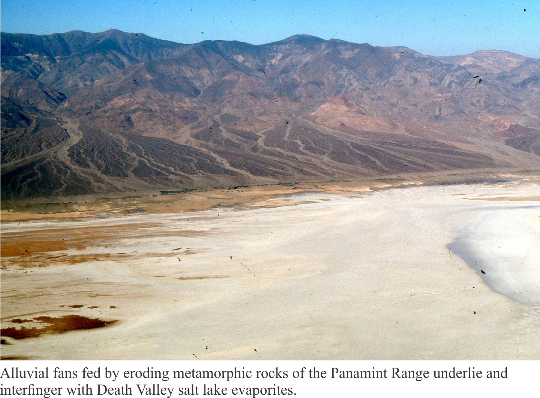
Most of the water entering Death Valley playa lake is delivered by subsurface groundwater flow, either as diffuse flow through aquifers, or from springs.  Spring flow is commonly focused along faults; perennial flows in Salt Creek, Armargosa River and Furnace Creek are spring-fed. Numerous small springs also occur at the toes of alluvial fans where they intersect the mud flats. Springs do flow at higher elevations in the adjacent ranges, but these have little influence on supply to the playa lake. Rare flash floods deliver surface runoff and sediment (commonly as debris flows or hyperconcentrated mud flows) across alluvial fans and along ephemeral streams, but this water evaporates quickly.

Phreatophytes eke out a living around springs and across parts of alluvial fans where plant roots can tap into the local watertable.

There are three main aquifers:

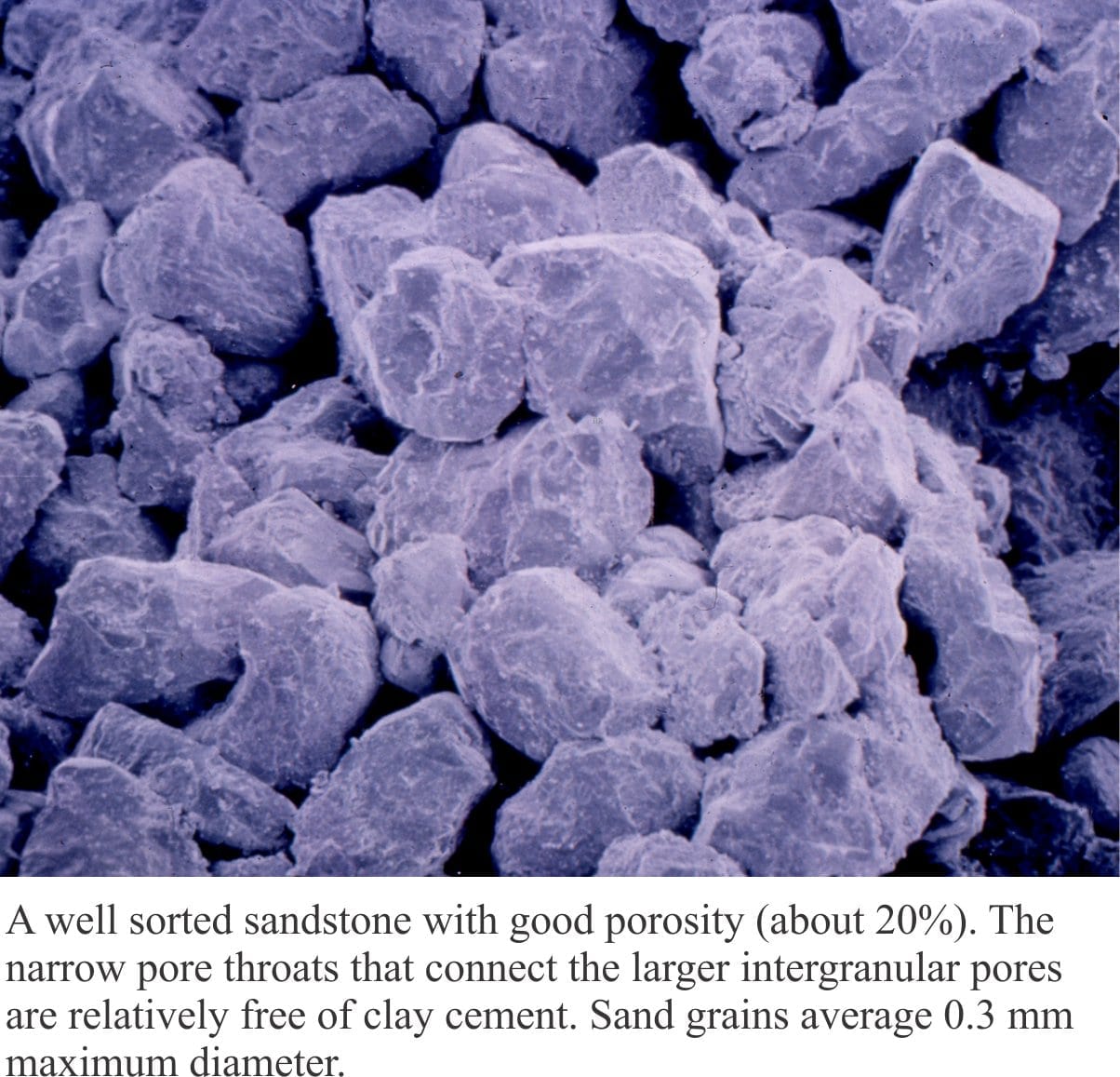
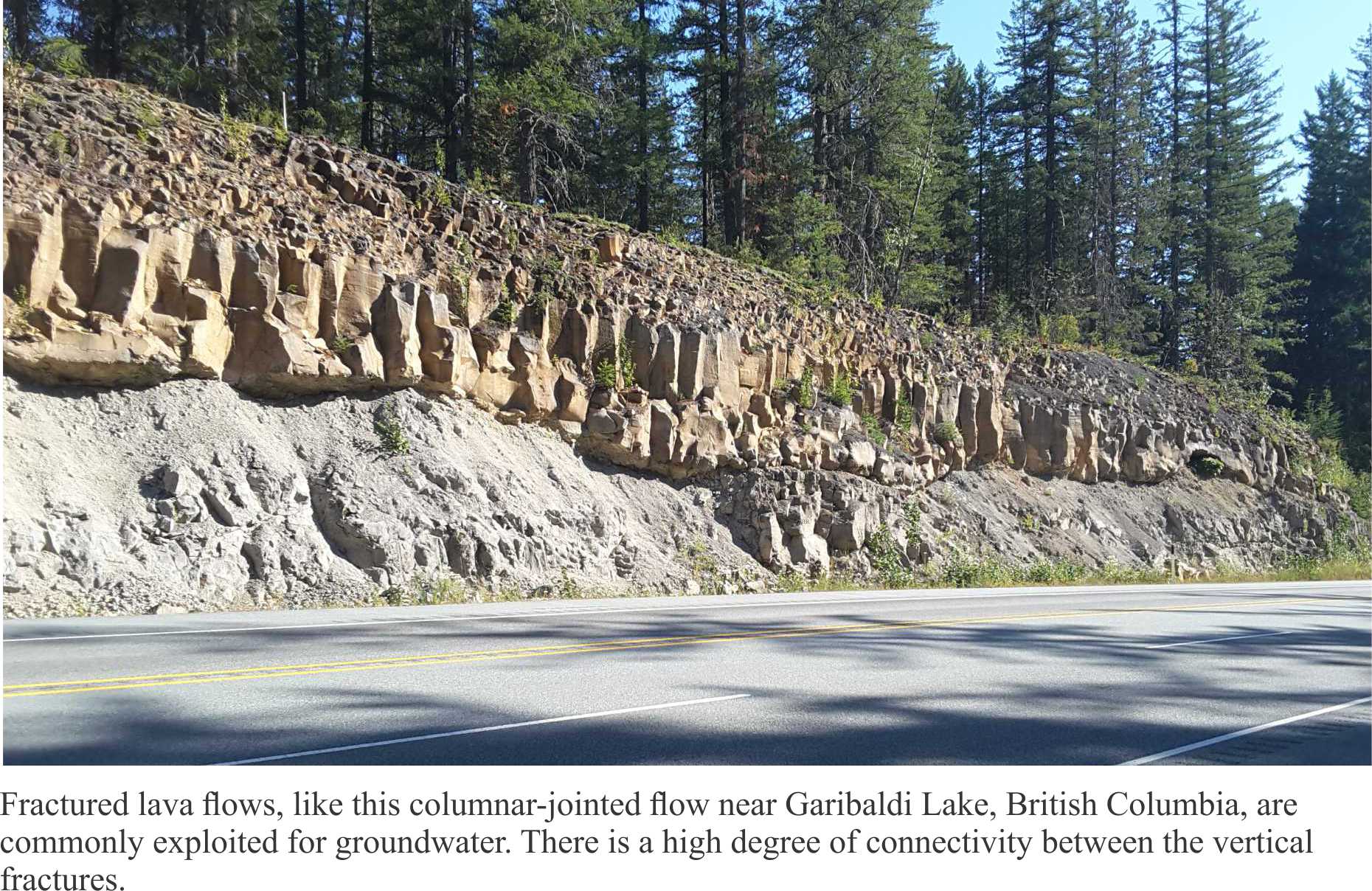
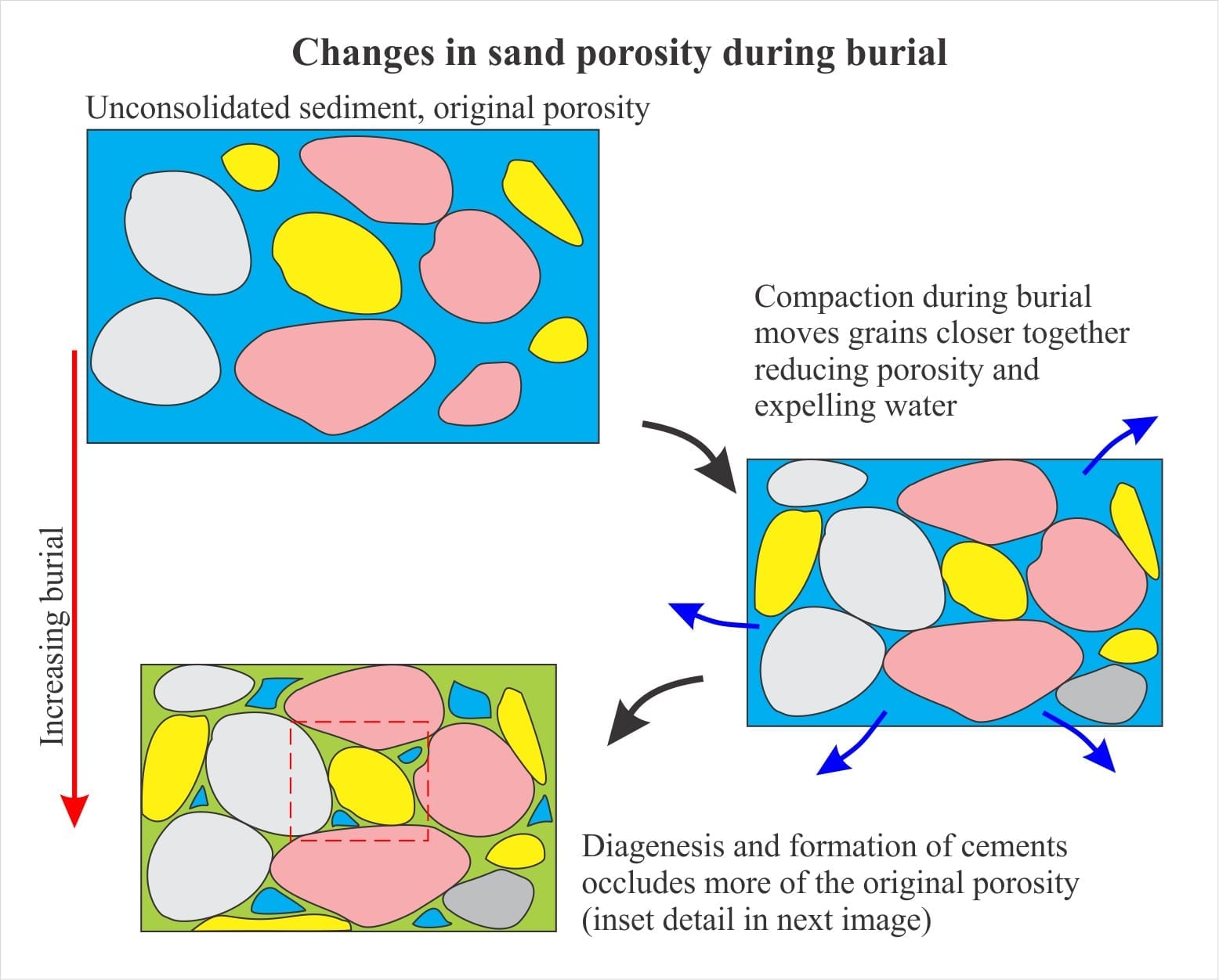
  1. Paleozoic and Mesozoic clastic and carbonate rocks that provide fracture porosity and, in the case of carbonate rocks, secondary porosity formed by dissolution of primary grains and cements. These aquifers (and aquitards) underlie the Panamint Ranges, Black Mountains, Funeral Mountains, extending to other ranges farther east.
  2. Pleistocene-Holocene, coarse-grained alluvial fans that drape the lower slopes of the mountains and interfinger with fine-grained playa lake deposits.
  3. Geothermal waters emanating from a magma body beneath Death Valley.

View towards Panamint Mts, recent alluvial fan, and saline lake; below is a giagramtic presentation of the Death Valley aquifer systems

Investigations of Death Valley hydrogeology in the 1950s and 60s established estimates for groundwater budgets. The main components for inflowing water are groundwater, precipitation; water discharge is primarily by evaporation and evapotranspiration (i.e. via plant transpiration) – there are no natural surface flowing outlets in Death Valley. From the calculations it was apparent that there is a budget imbalance, such that the volume of water discharged was greater than that accounted for by recharge from precipitation within the Death Valley drainage basin (most aquifer recharge occurs at high elevations) and locally derived groundwater. Thus, was borne the concept of interbasin flow, where groundwater is transferred from geographically disconnected basins elsewhere in the Basin and Range Province. Differences in groundwater chemistry among the basins supports this hypothesis (see the paper by W.R. Belcher et al. 2009 for an evaluation of the basin transfer concept using the Furnace Creek springs chemistry as an example).

Interbasin groundwater transfer requires a regionally extensive aquifer system – hence the recognition of the Death Valley Regional Aquifer Flow System (an aquifer system consists of stratigraphically related aquifers and aquitards that have common permeability attributes). The aquifer system in this case includes Paleozoic and Mesozoic clastic and carbonate rocks that occur in fault-bound panels beneath the basins and enclosing ranges (shown schematically in the diagram above). The faults themselves may act as conduits or barriers to flow depending on their permeability. The regional aquifer covers an area (approximately 23,000 sq. km) about three times that of Death Valley. Recharge is mostly at high elevations in the various mountains and ranges (shown on the diagram below). Groundwater residence times in the regional aquifer are probably counted in 10s of 1000s of years, long enough to acquire the Na, Ca, K, B, SO4, Cl, CO3-HCO3, and other trace ions that characterise the Death Valley inflow waters.

Death Valley potentiometric surface for the regional groundwater flow system. Arrows indicate hyrdraulic gradients

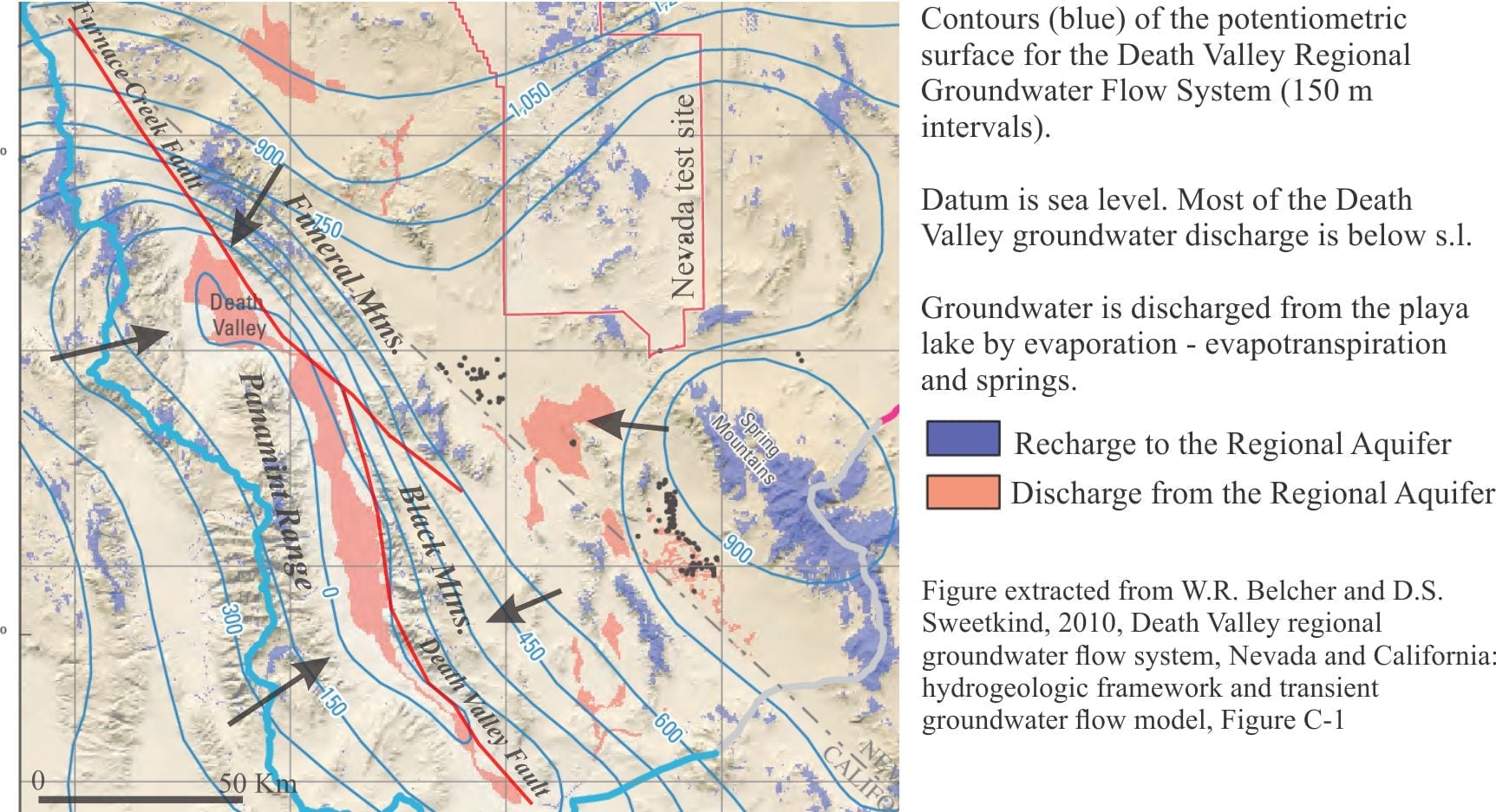
Groundwater also resides beneath the alluvial fans. Recharge to the fans is from direct precipitation and surface runoff from the adjacent ranges during winter precipitation and the occasional flash flood. The watertable is deepest at the upslope end of the fans, merging downslope with the watertable beneath the playa lake. The presence of this watertable is indicated by growth of phreatophytes. Groundwater flow through the alluvial fans comprises local, shallow flow systems that are superposed on the deeper regional flow.

Badwater Springs, Death Valley, the lowest, and one of the hottest places in North America

The third aquifer system is that associated with a magma body, located about 15 km deep south of Badwater. The magma body has been imaged as a bright spot by reflection seismic. A 700,000 year-old basalt cinder cone nearby provides additional evidence for the magma chamber. It is hypothesized that heated Ca-Cl waters are vented to the playa lake from springs, springs that in some cases flow through faults created during magma intrusion. Ca-Cl rich waters are restricted to the area above the magma chamber where they mix with Na-HCO3-SO4 waters derived from the Regional Aquifer.


Related links

Mineralogy of evaporites: The rise of diapirs

Mineralogy of evaporites: salt tectonics

Mineralogy of evaporites: Saline lakes

Mineralogy of evaporites: Marine basins

Mineralogy of carbonates; carbonate factories

Mineralogy of carbonates; basic geochemistry

Mineralogy of carbonates; meteoric hydrogeology

Mineralogy of carbonates: sabkhas

Whiskey is for drinkin’; water is for fightin!

The Architecture of Connected Holes; A Different Way to Look at the Liquid Earth

A misspent youth serves to illustrate groundwater flow

Contrails, analogies, and visualizing groundwater flow

Springs and seeps


References

M.S. Bedinger and J.R. Harrill. 2012. Groundwater Geology and Hydrology of Death Valley National Park, California and Nevada. National Park Service, U.S. Dept. of Interior, Natural Resource Technical Report 2012/652.       A comprehensive account of DV. Includes a discussion of the influence of glacial-interglacial changes in climate during the Pleistocene, the succession of lakes during pluvial dominant climates, and the alternation of evaporite – non-evaporite conditions.

W.R. Belcher, M.S. Bedinger, J.T. Back and D.S.Sweetkind, 2009. Interbasin flow in the Great Basin with special reference to the southern Funeral Mountains and the source of Furnace Creek Springs, Death Valley, California, U.S. Journal of Hydrology, v. 369, p. 30-43

W.R. Belcher and D.S.Sweetkind, 2010, Death Valley regional groundwater flow system, Nevada and California: hydrogeologic framework and transient groundwater flow model. U.S.G.S. Professional Paper 1711.

C. Del Pardo, B.R. Smith-Konter, L.F.Serpa, C. Kreemer, G, Blewitt, W.C. Hammond. 2012. Interseismic deformation and geologic evolution of the Death Valley Fault Zone. Journal of Geophysical Research, v. 117

Li, J., Lowenstein, T.K. and Blackburn, I.R. 1997. Responses of evaporite mineralogy to inflow water sources and climate during the past 100 k.y. in Death Valley, California. Geological Society of America Bulletin, 109, p. 1361-1371.    The paper that identifies three chemical groups of inflow waters.

T.K. Lowenstein and F. Risacher, 2009. Closed basin brine evolution and the influence of Ca-Cl inflow waters: Death Valley and Bristol Dry Lake, California, Qaidam Basin, China, and Salar de Atacama, Chile. Aquatic Geochemistry, v. 15, p. 71-94. Focuses on the Ca-Cl waters originating from a magma chamber beneath DV. Also describes briefly the changes wrought by recurring pluvial periods during the Pleistocene.

Facebooktwitterlinkedininstagram
Facebooktwitterlinkedin

Mineralogy of evaporites: saline lake brines

Facebooktwitterlinkedininstagram
Gypsum books, several cm across, precipitated from supersaturated brines within fine-grained sediment and exumed by wind ablation. Altiplano, Chile

Gypsum books, several cm across, precipitated from supersaturated brines within fine-grained sediment and exhumed by wind ablation. Altiplano, Chile

The evolution of brines that produce saline lake evaporites.

This is part of the How To…series  on evaporites


Seawater is generally considered to be isochemical because its composition varies little from sea to sea. There are some changes in saturation levels of calcite and aragonite in deep ocean waters (below their compensation depths), and salinity in basins having more restricted seawater inflow (e.g. Mediterranean Sea, Arabian Gulf), but the range of composition variation is limited. This means that evaporation of seawater follows a predictable chemical and thermodynamic path.

Not so terrestrial waters (rivers, groundwater) whose starting compositions are remarkably varied. Most natural waters contain Na in abundance plus an array of cations and anions like K+, Ca2+, Mg2+, Cl, SO42-, HCO3, CO32-, and SiO2. But the starting concentrations of these ions varies greatly meaning that the resulting evaporite mineralogy is also varied. Enter Lawrence Hardie and Hans Eugster whose chemical modelling in the late 1960s and 70s showed us how to make sense of this natural variability and complexity. Their publications are still cited 50 years later (a few are listed below); they are compulsory reading for any student who is interested in evaporites and geochemistry.

Hardie and Eugster (1970) calculated evaporation paths and mineral products for natural waters having different compositions at atmospheric pressure and 25oC. The waters are assumed to be in equilibrium with CO2 (pCO2 is constant) – this is important for CO32- and HCO3 and calculation of pH.  Some of the relevant calculations have been described in a previous post on carbonate geochemistrythe same principles apply to evaporites.

  • Equilibrium constants for each mineral (common evaporite minerals from saline lakes are listed below),
  • Ion activities and activity coefficients,
  • Ion activity products (IAP),
  • Degree of mineral saturation,
  • Ionic strength, low values in dilute water, increasing with evaporation,
  • Note that complex ion pairs are not included in the calculations.

As water evaporates, the activities of cations and anions increases. If the ion activity product equals the equilibrium constant for a mineral, then the solution has become saturated and that mineral will precipitate; at this point the IAP remains constant. The important results in this process are, using calcite as an example:

  • During precipitation, both Ca2+ and CO32- are removed from the original water in equal proportions,
  • Calcite will continue to precipitate until one or both Ca2+ and CO32- have been depleted.
  • It is likely that the original concentrations of Ca2+ and CO32- are not equal. If, in this example Ca2+ > CO32-, then calcite will precipitate until the CO32- is used up, leaving excess Ca2+ available for some other mineral like gypsum.
  • If on the other hand Ca2+ < CO32-, then the Ca2+ will be depleted first leaving none for gypsum.
  • Water is continually removed during evaporation and its concentration decreases; if the process proceeds to desiccation then the concentration of water is zero.

As evaporation proceeds the model predicts which minerals are likely to precipitate and which will not, depending on the starting composition of the water. The succession of mineral precipitates defines the evaporation path for that particular water.

Two reasonably typical examples are shown below (from Hardie and Eugster, 1970, Figure 2). Here, the apices of each triangle plot the changes in ion concentrations as evaporation proceeds. For the example of calcite precipitation, the path moves away from the Ca and CO32- – HCO3 apex towards the Cl apex.

Two examples of ternary plots of water-brine evolution showing brine evolution pathways

Note that the evaporation paths turn abruptly at the point where precipitation depletes the relevant ions.

Example (a): Sulphate rich water that evolves to a Cl brine via precipitation of gypsum.

Example (b): Carbonate rich – sulphate poor water; no gypsum precipitates and the system evolves to a CO3–Cl brine. If calcite precipitates, the brine will likely become rich in Na and K. Halite saturation will be reached if evaporation continues.

In their model, brine evolution curves are complicated by SiO2 and precipitation of sepiolite (illustrated in the flow-path diagrams below). Sepiolite is a hydrated Mg-silicate; its precipitation will influence the Mg path. Precipitation of sepiolite also releases H+ and is therefore an important part of pH buffering (along with the carbonate equilibria). As pH is lowered, CO32- will decrease. Therefore, there is potential for reversal of the CO32- enrichment trends.

Hardie and Eugster (1970) identified 4 important groups of natural waters; Eugster and Hardie (1978) added a fifth group. Note (1) not all waters will fit neatly into one of these groups, and (2) the ions that define each group are dominant –subordinate cation and anion species will also be present:

  • Na–CO3-Cl
  • Na–CO3-SO4–Cl (e.g. Lake Magadi, Kenya)
  • Na–(Ca)–SO4-Cl (e.g. Great Salt Lake, Utah)
  • Mg–Na–(Ca)–SO4-Cl (Poison Lake, Washington)
  • Ca–Mg–Na–(K)–Cl (Bristol Dry Lake, Mohave Desert, California; Dead Sea)
Table of common evaporite minerals in saline lakes; click on the image to enlarge

Table of common evaporite minerals in saline lakes; click on the image to enlarge

In all waters, alkali metal carbonates are the first to precipitate, particularly calcite or aragonite depending on the Mg/Ca ratio. This is a critical first stage in evaporation because it determines the subsequent precipitation sequence of minerals as Ca2+ and CO32- are removed from solution. This is the Calcite Divide, separating waters that become HCO3 rich or  HCO3 poor (keep in mind that continued evaporation increases the overall ionic strength). Depending on the SO4 concentration, excess Ca results in gypsum precipitation that, in turn, creates the next geochemical divide – the gypsum divide that determines whether the brines evolve as SO4 rich – Ca poor, or SO4 poor – Ca rich. One of the last minerals to precipitate is halite from Cl-rich brines.

Brine evolution is shown diagrammatically below (modified from Figures 7 & 8 in Hardie and Eugster, 1970; Warren, 2016, Fig. 2). The two pathways represent waters that include sepiolite precipitation, and those lacking significant aqueous SiO2. For the case where sepiolite precipitates, there is an additional path towards gypsum saturation because of the pH effect on CO3-HCO3 (noted above), such that the brine becomes enriched in Ca.

Schema for brine evolution pathways, showing the calcite and gypsum divides

You should also check the flow diagram in Warren (2016) Figure 2, that shows in greater detail complications such as changes in Mg/Ca ratios, variations in HCO3, in addition to sepiolite production.

In this post, I have focused on the work of Hardie and Eugster because it has been pivotal in guiding more recent research. Of course, there have been modifications and improvements to their models, and you can access these recent advances in the literature cited below.

Links to related topics

Mineralogy of evaporites: The rise of diapirs

Mineralogy of evaporites: salt tectonics

Mineralogy of evaporites: Saline lakes

Mineralogy of evaporites: Death Valley hydrology

Mineralogy of evaporites: Marine basins

Mineralogy of carbonates; classification

Mineralogy of carbonates; carbonate factories

Mineralogy of carbonates; basic geochemistry

Mineralogy of carbonates; meteoric hydrogeology

Mineralogy of carbonates: sabkhas


References

M. Babel and B.C. Schreiber, 2014. Geochemistry of evaporites and evolution of seawater. Treatise on Geochemistry. Elsevier, p. 483-560. Deals with marine evaporites but many aspects relevant to non-marine. Encyclopedic with extensive list of references

D.M. Deocampo and B.F. Jones. 2014. Geochemistry of Saline Lakes. Treatise on Geochemistry. Elsevier, p. 437-469. Encyclopedic with extensive list of references

H.P.Eugster, 1980. Geochemistry of evaporitic lacustrine deposits. Annual Review of Earth & Planetary Sciences, v. 8, p. 35-63.

L.A. Hardie and H.P.  Eugster, 1970. The evolution of closed basin brines. Mineralogical Society of America, Special Paper v. 3, p. 273-290. 50 years old but still an iconic paper and a must-read.

J. Warren, 2016. Evaporites. In W.M. White (Ed.) Encyclopedia of Geochemistry. Springer International, p. 1-8. Concise summary of saline lake and marine brine.

Facebooktwitterlinkedininstagram
Facebooktwitterlinkedin

Mineralogy of evaporites: Saline lakes

Facebooktwitterlinkedininstagram

Saline lake evaporites – some general physical and chemical conditions

This is part of the How To…series  on evaporites

Evaporites are rocks formed by precipitation of water-soluble salts under conditions of intense evaporation. The overarching condition is that evaporation of surface waters exceeds inflow or recharge, such that mineral saturation or supersaturation is maintained. From a geological perspective this usually requires basins to be closed. This is fairly easy to visualize in small land-locked basins like salt lakes, playa lakes, and salars that are bound by topographic barriers or where surface drainage is minimal or non-existent – in such cases new water may flow into the basin but none leaves, except by evaporation (a kind of Hotel California of evaporites).

Evaporites formed in oceanic systems are quite different. Iconic examples like the Permian Zechstein Sea indicate such basins were huge. These basins must still be hydrologically ‘closed’ such that surface evaporation exceeds seawater inflow, which means that mixing of normal seawater and saturated water must be kept to a minimum.  Thus, we might expect such conditions on shallow platforms that are protected by a barrier of some kind (like the Late Miocene-Pliocene Messinian Mediterranean Sea), or in deeper basins where salinity stratification is maintained. Notably, there are no modern analogues for these types of evaporite deposit.

The notes here are a brief (and incomplete) introduction to saline lake evaporites. The literature I have drawn on (below) is more encyclopedic.


Tectonics

Tectonics ultimately controls the conditions in which evaporites form: topography, climate ( humidity and precipitation), groundwater flow and surface drainage, bedrock composition and its weathering products. Tectonic-geomorphic controls on closed-basin evaporites are a lesson in contrasts:

  • Australian basins, like the ephemeral Kati Thanda – Lake Eyre, or the acidic salt flats in Yilgarn, have formed on ancient, stable, deeply weathered Precambrian cratons;
  • The Death Valley salt lakes occur in a region of active crustal extension – the Basin and Range Province. In northeast Africa, Magadi Lake is one of a string of salt lakes in the East African Rift.
  • Dead Sea fills a pull-apart basin along the Dead Sea Transform Fault System – the lithospheric-scale strike-slip boundary between the African and Arabian plates;
  • Salars of the Chilean Altiplano-Atacama region are nestled against volcanic complexes, including calderas, associated with Andean subduction.

Alluvia; fans draping the tows of Panamint Moutains, Death Valley

Climate

For evaporites to accumulate, evaporation must balance or exceed water inflow from precipitation, surface runoff, or groundwater seepage. This does not mean that it can never rain in such places, but that floods or deluges must be short-lived. Even the Atacama Desert receives a few drops of rain or rare flash floods.

All evaporites occur in arid climates. We commonly associate aridity with warmth – Kati Thanda – Lake Eyre, Dead Sea and Death Valley are but three (of many) regions associated with subtropical deserts. Evaporites can also accumulate in cold, even frigid climates; good examples can be found in the Dry Valley lakes of Antarctica (common gypsum and halite) where mean annual temperatures range from -15oC to -30oC. Likewise, many salars of the Chilean Atliplano are at elevations of about 4000 m, where summer temperatures are cool and humidity is close to zero. While temperature may not determine where an evaporite deposit will form, higher temperatures do increase the rates of evaporation and mineral precipitation. Temperature will also control the local micro- and macro-biota, both of which can influence mineral precipitation and the REDOX conditions of lake waters.


Hydrology and hydrogeology

Basins that lack outgoing surface drainage are called endorheic basins. Such basins are surrounded by drainage divides and the area of drainage can be significantly greater than that of the enclosed lake. Water enters these basins as surface runoff (rain or snow melt), groundwater seepage, direct precipitation and in some cases hydrothermal flow. Except for precipitation, all these fluid inputs must contain sufficient solute. It is the balance among all these inputs against evaporation that maintains levels of mineral saturation-supersaturation or desiccation.

The elevated topography ensures that groundwater flow is towards the lake. Groundwater will exit at the shoreline and if there is sufficient hydraulic drive (depending on the amount of topographic relief) seepage may occur across the lake floor. Surface runoff,  occasionally manifested as flash floods, will also deposit clastic sediment along the lake margins. For example, alluvial fans may interfinger with evaporite deposits.

Groundwater seepage along the shoreline of a saline lake, or salar. White crusts are gypsum and halite. Chilean Altiplano.


Evaporite composition

Oceanic evaporites are formed from seawater, the composition of which has probably not varied much over geological time. In contrast, and as Hardie and Eugster (1970) state in one of their iconic papers on saline lakes, the “composition of brines … exhibits a bewildering range”. There is an equally impressive array of evaporite minerals – several of the publications listed below tabulate the mineral species. The original composition of saline lake waters is governed by several factors:

Wind ablation of gypsum-halite crusts across a Chilean Altiplano salar

  • Most natural waters contain plenty of Na, plus a relatively limited array of other cations and anions like K+, Ca2+, Mg2+, Cl, SO42-, HCO3, CO32-, and some SiO2.
  • Bedrock-soil composition through which waters seep. Surface weathering and soil development, particularly soils influenced by microbes, will be strong determinants of lake water compositions. For comparison, limestones will produce calcium and carbonate rich waters with slightly elevated pH values (pH 8-9), whereas rocks containing sulphides will produce more acidic waters where HCO3 and CO32- are absent (unstable). Those having a surfeit of alkali metal carbonates (most commonly Na, K and Li) can have pH values >10. Lithium is commercially important in brines beneath several salars of Chile, Bolivia and Argentina.
  • Residence time of groundwater: this is basically the time taken from infiltration at the surface, to surface seepage at some location down hydraulic gradient. Longer residence times usually give rise to higher solute concentrations.
  • Hydrothermal fluid input can introduce ion species less abundant than in more local bedrock, as well as influencing lake water temperature.
  • Large saline lakes may be become salinity and density stratified. Upper layers will tend to be more oxygen-rich because of regular mixing; deeper layers more anoxic. Salinity stratification is an important control on REDOX conditions throughout lake waters.
  • REDOX conditions: Oxidation can play a significant role in fluid composition where sulphides are present in bedrock (commonly as mineralization). Sulphides readily oxidize to sulphate, releasing cations like iron (Fe2+ becomes Fe3+) and acidic waters (this is one of the main problems of acid-mine drainage). In larger lakes, the upper layers can support phototrophic and other organisms (e.g. algae, diatoms), that ultimately sink through the brine layer to the lake floor where decay consumes any remaining oxygen. Here, the salinity boundary acts as a chemocline, a chemical boundary, below which the redox conditions change drastically. Under these conditions, metal oxides like Fe2O3 may dissolve and any sulphate is reduced to sulphide; this may happen at or below the sediment-water interface where metal cations like Fe, Cu, Mn, Pb and Zn are stabilized as their respective sulphides. The deeper anoxic brines may also support methanogenic or anaerobic bacteria.
  • Cycle of wetting and drying: Maintenance of evaporite conditions requires intense evaporation over relatively long periods. However, successive wetting and drying cycles can influence brine and mineral compositions. Under shallow conditions, wetting (e.g. rain) can dissolve some minerals and temporarily change the saturation state of lake and interstitial fluids; for example, halite dissolves readily, potentially removing Na and Cl from the site. Drying eventually results in the kind of evaporative pumping witnessed on sabkhas, moving water and solute from the watertable through the capillary zone. In larger lakes, extended dry periods may shift brine stratification boundaries in concert with lower lake levels and migrating shorelines. Brief periods of precipitation will increase mixing and oxygenation of upper lake layers, perhaps even diluting the deeper brines. Any sediment introduced to the lakes, particularly bottom-hugging sediment gravity flows, may also modify brine stratification and disturb chemoclines.

The next post deals with closed-basin brine composition and evolution

The photo of Death Valley salt polygons is from Marli Miller’s beautiful image collection.


Links to related posts

Mineralogy of evaporites: salt tectonics

Mineralogy of evaporites: Saline lake brines

Mineralogy of evaporites: Death Valley hydrology

Mineralogy of evaporites: Marine basins

Mineralogy of carbonates; classification

Mineralogy of carbonates; carbonate factories

Mineralogy of carbonates; basic geochemistry

Mineralogy of carbonates; meteoric hydrogeology

Mineralogy of carbonates: sabkhas


References

K.C. Bennison and B.B. Brown. 2015. The evolution of end-member continental waters: The origin of acidity in southern Western Australia. G.S.A. Today, v. 25, No. 6, p. 4-10.

D.M. Deocampo and B.F. Jones. 2014. Geochemistry of Saline Lakes. Treatise on Geochemistry. Elsevier, p. 437-469.

L.A.Hardie. 1991. The significance of evaporites. Annual Review Earth & Planetary Sciences, v. 19, p. 131-168. Click on the OA full text icon top right.

L.A. Hardie and H.P.  Eugster, 1970. The evolution of closed basin brines. Mineralogical Society of America, Special Paper v. 3, p. 273-290. 50 years old but still an iconic paper and a must-read.

J. Warren, 2016. Evaporites. In W.M. White (Ed.) Encyclopedia of Geochemistry. Springer International, p. 1-8. Concise summary of saline lake and marine brine.

Facebooktwitterlinkedininstagram
Facebooktwitterlinkedin

Mineralogy of carbonates; Sabkhas

Facebooktwitterlinkedininstagram

Abu Dhabi sabkha panorama

Modern marine sabkhas – transitions between carbonates and evaporites

This is part of the How To…series  on carbonate rocks

The development of sedimentary facies models based on modern depositional analogues flourished in the 1960s and 70s on the heels of foundational work by 1950s icons (I’m loath to name them because I’m bound to miss someone out). Modern sabkhas were an important part of this trend as a worthy and convenient analogue for many ancient marine evaporite deposits, convenient in the sense that the analogue model was sometimes applied to evaporites even when evidence for “shallow marine conditions” were lacking. It is now firmly established that not all evaporites require a seawater precursor.

Sabkhas and the depositional models derived from them are important because:

  • they are part of a sedimentologist’s toolbox for interpreting ancient environments (sedimentary facies, stratigraphy, and geochemistry),
  • sabkha diagenesis includes rapid precipitation (and dissolution) of halite at the surface, gypsum-anhydrite in the shallow subsurface, and carbonate hardgrounds,
  • they are one of the few sedimentary environments where recent dolomite precipitates,
  • they help define the excursions of paleo-shorelines (regression, transgression),
  • they place narrow boundary conditions on paleoclimates,
  • it is possible to track ancient seawater compositions, and
  • they provide a kind of go-between for marine carbonate and evaporite facies.

The classic areas of study (one might refer to it informally as the ‘type area’) are the shallow  coasts of Abu Dhabi (United Arab Emirates, until 1971 referred to as Trucial states) and Qatar. They are the coastal and inland extensions of the shallow, ramp-like Arabian Gulf. Despite its geological and ecological importance, only about a third of the original Abu Dhabi sabkha coast has escaped urban and industrial encroachment (Lokier, 2013).

Sabkhas are important components of coastal plains, comprising supratidal flats and salt marshes that periodically are flooded by spring tides. They are characterised by a mix of evaporite minerals (predominantly gypsum, anhydrite and halite) and carbonates, and hence are generally restricted to hot arid climates (Abu Dhabi and Qatar sabkhas straddle the Tropic of Cancer). In places, the sabkhas extend inland for 30km; they are remarkably flat having slopes less than 0.1o (Lokier et al. 2018), which means that even minor excursions of relative sea level will have a profound effect on shorelines and associated facies.

Modern sabkhas occur at several other locations (e.g. Sinai Peninsula, and Coorong Lagoon south of Adelaide) but we will focus on Abu Dhabi. Here the coast is bordered by numerous small islands, separated by tidal channels and enclosing lagoons floored by carbonate mud, ooid and skeletal carbonate shoals, and beaches. Small reefs have grown on the seaward margins of some islands. Inland, beach ridges as old as 4000 years provide good evidence for ancient shorelines, successively abandoned during coastal progradation.

Abu Dhabi facies map

A typical transect across the Abu Dhabi coastal plain encounters sedimentary facies that are also represented in shallow stratigraphic sections (revealed in cores). I have drawn on the excellent descriptions in classic papers by Evans et al (1964), Illing et al (1965),  Kendall and Skipwith (1969), Bathurst (1976, Chapter 4), and more recent contributions by Paul and Lokier (2017), and Lokier et al. (2017).

Lower intertidal and subtidal areas are floored primarily by skeletal and pelloidal sands, drained by tidal channels. Local sheltered spots contain aragonite muds. There is a bustling benthic community of molluscs, particularly grazing Cerithiid gastropods and burrowing crabs, echinoderms, foraminifera and calcareous algae.

sabkha cerithiid lag

An important early diagenetic component of this facies belt is a hardground, composed mainly of skeletal debris and cemented by high-Mg calcite, aragonite and some dolomite. Exposed hardgrounds are frequently broken into polygons that may have been caused by desiccation. They occur at the surface in the modern intertidal zone but can be traced landward beneath the sabkha surface. Dating of cemented shells by C14 indicates ages up to 7000 years BP beneath the sabkha. Hardground formation seems to have kept pace with the migrating shoreline during late Holocene progradation.

The upper intertidal realm is characterised by a belt of algal mats up to 600 m wide (also referred to as microbial or cyanobacteria mats, and stromatolites). Seaward and landward boundaries of this facies belt are well defined: the former by grazing Cerithiids and crabs that cannot thrive in the elevated salinities higher up-slope; the latter by intense desiccation that characterises the sabkhas. The leathery mats are commonly arranged as decimetre-sized polygons with up-turned and overturned margins, long considered to be the product of desiccation. This hypothesis has been challenged by Lokier et al (2017) who observed breakage during competitive mat growth, such that polygon margins are progressively displaced, overthrust or overturned. Overgrowth by a new generation of microbes can be recognized by the small discordances between mat layers. The polygons sometimes contain gypsum crystal mush. Incipient aragonite and gypsum cements are found beneath some mats.

sabkha algal-microbial mats

A range of mat morphologies are present, depending on the regularity of tidal flooding and desiccation. Flatter, or pustular forms are more common in lower intertidal zones. Crinkly and tufted forms tend to occupy upper intertidal regions where desiccation is more intense. Mats that are completely dried are reworked during spring tides.

The sabkha facies extends inland from the upper intertidal zone. It tends to be flat, featureless, and devoid of vegetation. Halite crusts are common; large gypsum crystals commonly poke through the surface sediments. The halite is ephemeral – it dissolves during spring tides and any brief periods of rain.

sabkha gypsum laths

There is an important relationship between the mineralogy of sabkhas, evaporite crystal growth, and depth to the permanent watertable; note that in general, the watertable will rise towards the surface at it approaches the shoreline. These phreatic brines provide the solute for precipitation of gypsum, anhydrite, and halite. Transfer of solute to the overlying (unsaturated) vadose zone and sabkha surface is by evaporative pumping. Thus, most of the gypsum and anhydrite is precipitated in the capillary zone above the watertable, the crystals displacing sediment as they grow (the capillary zone is not permanently saturated with groundwater but is wetted at grain contacts).

Sabkha structures that have reasonable preservation potential are Tepees –  conical or inverted ‘V’ structures in broken, cemented crusts and hardgrounds. The crusts are cemented by aragonite and high Mg calcite, but also form in surficial halite. Tepee structures and their associated polygons form by expansion of rapidly cementing surface sediment; the expansion causes breakage that leads to upturned, overturned, and overthrust crust fragments. Tepees formed of carbonate crusts are commonly peritidal, at the junction between the watertable and sediment surface. Those formed in halite are supratidal (like the examples shown here). Tepee structures have been recognized in many ancient carbonates.

sabkha tepee structures

The watertable beneath Abu Dhabi sabkhas is usually less than 1 metre below the surface. Groundwater here is highly saline – some measured salinities are 10-20 times that of seawater. The recharge to groundwater needs to balance that lost by intense evaporation. Early workers thought that periodic surface flooding by seawater, or perhaps landward subsurface seepage of seawater would suffice. However, hydrogeological analysis by Sanford and Wood (2001) showed that these processes were relatively minor. Two other processes dominate recharge: upward seepage of groundwater from deeper permeable units, and downward infiltration from rainfall – the latter being most significant. Rainfall also has the potential to change evaporite chemistry – it will dissolve halite (halite has low preservation potential) and may create (temporary) unsaturated conditions for gypsum and anhydrite, resulting in a degree of dissolution.

sabkha stratigraphy


Stratigraphy

A typical stratigraphic column for Abu Dhabi sabkhas is shown below. The profile (dug to the watertable) records sabkha progradation over intertidal algal mats and cerithiid lags, and subtidal (lagoonal) mixed carbonate plus siliciclastic silts and muds. Displacive gypsum and anhydrite crystals up to 10 cm long occur in several layers. A hardground at the base of this section is the buried equivalent of the hardground presently forming in the intertidal-subtidal facies belts.

The muds, silts and algal mats account for about 60-70% of the local stratigraphy. During compaction and lithification, the thickness of these lithologies will be significantly reduced to the extent that the other layers may appear over-represented. For example, the mat layer, about 150 mm thick would, upon compaction, be represented by a layer no more than a few millimetres thick. In comparison, the thickness of the cerithiid layer may change very little. The halite crust may not be preserved at all!


The sabkha photos generously contributed by Stephen Lokier, are indicate on each figure.


References

G. Evans, C.G.St.C. Kendall and P. Skipwith. 1964. Origin of the coastal flats, the Sabkha of the Trucial Coast, Persian Gulf. Nature, v. 202, p. 759-761.

L.V. Illing, A.J. Wells and J.C.M. Taylor. 1965. Penecontemporary dolomite in the Persian Gulf. In, Dolomitization and limestone diagenesis, a symposium. SEPM Special Publication v.13, p. 89-111.

C.G.St.C. Kendall and P.A.D.E. Skipwith, 1969. Holocene shallow water carbonate and evaporite sediments of Kor al Bazam, Abu Dhabi, southwest Persian Gulf. AAPG Bulletin, v. 53, p. 841-869.

S.W.Lokier. 2013. Coastal Sabkha Perservation in the Arabian Gulf. Geoheritage, v. 5, p.11-22.

S.W. Lokier et al. 2017. A new model for the formation of microbial polygons in a coastal sabkha setting. The Depositional Record, v.3, p. 201-208. Open Access.

S.W. Lokier, W.M. Court, T. Onuma and A. Paul. 2018. Implications of sea level rise in a modern carbonate ramp setting. Geomorphology, v. 304, p. 64-73.

A. Paul and S.W. Lokier, 2017. Holocene marine hardground formation in the Arabian Gulf: Shoreline stabilization, sea level, and early diagenesis in the coastal sabkha of Abu Dhabi. Sedimentary Geology, v. 352, p. 1-13.

W.E. Sanford and W.W. Wood. 2001. Hydrology of the coastal sabkhas of Abu Dhabi, United Arab Emirates. H 358-366.ydrogeology Journal, v.9, p.


Links to other posts in this series:

Mineralogy of carbonates; skeletal grains

Mineralogy of carbonates; non-skeletal grains

Mineralogy of carbonates; lime mud

Mineralogy of carbonates; classification

Mineralogy of carbonates; carbonate factories

Mineralogy of carbonates; basic geochemistry

Mineralogy of carbonates; cements

Mineralogy of carbonates; sea floor diagenesis

Mineralogy of carbonates; Beachrock

Mineralogy of carbonates; deep sea diagenesis

Mineralogy of carbonates; meteoric hydrogeology

Mineralogy of carbonates; Karst

Mineralogy of carbonates; Burial diagenesis

Mineralogy of carbonates; Neomorphism

Mineralogy of carbonates; Pressure solution

Mineralogy of carbonates: Stromatolite reefs

Facebooktwitterlinkedininstagram
Facebooktwitterlinkedin

Mineralogy of carbonates; Burial diagenesis

Facebooktwitterlinkedininstagram
Variables of temperature, pH, and organic solvents in sandstone-limestone burial diagenesis. From Surdam et al. 1989

Modified from Surdam et al, 1989


This is part of the How To…series  on carbonate rocks

Some general statements about the diagenesis of limestones during burial.

As sediment is buried, the combined effects of temperature, pressure and changing fluid composition act to lithify, overprint, and even obliterate all previous diagenetic histories. In limestones, the original sediment components and any early cements formed during seafloor or shallow meteoric diagenesis, are cemented, replaced by more stable carbonate phases, or recrystallized.  Burial diagenesis is governed primarily by:

  • Increasing temperature as a function of the local geothermal gradients,
  • Increasing hydrostatic pressures with depth and sediment/water loads,
  • Reactions resulting from organic maturation where pH buffering and changes in pCO2 drastically shift the stability of carbonates,
  • Reactions involving silicates (especially clays) that also change fluid composition and pCO2,
  • Tectonically induced faulting and folding that can alter permeability pathways, and
  • Tectonic uplift that reduces ambient temperatures and pressures and exposes indurated rock to meteoric conditions.

Continue reading

Facebooktwitterlinkedininstagram
Facebooktwitterlinkedin

Mineralogy of carbonates; Karst

Facebooktwitterlinkedininstagram

Karst depicted in late 14th century chinese painting

Karst landscapes – limestone dissolution, saturation and kinetics.

This is part of the How To…series  on carbonate rocks

Mountains in traditional Chinese painting are commonly depicted as pinnacles appearing out of some ethereal mist, bound by precipitous faces; symbols of some heightened awareness, an expression of deep time. And in the fertile valleys below an alternative, ephemeral human presence, almost an afterthought.

As surreal and metaphorical as these iconic images seem, they are rooted in real-world landscapes, the karst of southern China’s Guizhou, Guangxi, Yunnan and Chongqing provinces that in 2007 were designated a UNESCO World Heritage site. Its cones, pinnacles, sinkholes, caves, bridges and Shillin (Stone Forests) developed in thick Devonian to Triassic limestone. This is one of the classic regions for tropical and subtropical karst.


classic tropical karst in Guangxi Province, south China

Karst surface and subsurface structures are sculpted in limestone, dolostone and evaporites like gypsum and anhydrite. In all cases, the primary process is dissolution in the meteoric vadose and shallow phreatic zones. Therefore, karst is best developed in humid climates: prime examples include the tropical-subtropical landscapes of South China, temperate New Zealand (on Oligocene limestones), and the glacial – post-glacial of Ireland (the Burrens, that are underlain by Carboniferous limestone).


Pinnacle karst in Oligocene Te Kuiti Gruop limestone, Waitomo, NZ


Clints and grykes in Carboniferous limestone, the Burrens, west Ireland

Karst formation provides a good opportunity to examine two competing diagenetic processes –  dissolution and precipitation in terms of solution saturation, chemical kinetics, and groundwater flow.


Dissolution controlled by calcite saturation

Dissolution of limestone at the Earth’s surface is summarized in the following reaction (keeping in mind that all the carbonate equilibria are involved depending on pH, temperature, and concentrations or activities):

CaCO3 + H2O + CO2(aqueous) → Ca2+ + 2HCO3                   (1)

An important determinant for calcite dissolution is the degree of saturation. Dissolution will take place in solutions that are undersaturated, precipitation in solutions that are over- or supersaturated with respect to calcite. For calcite, the degree of saturation in a solution is calculated by comparing its ion-activity product with the solubility product (i.e. the ion product if that solution were at equilibrium under the same conditions of temperature and pressure). The ratio between these two activity products is called the saturation (Ω). Ω values less than one indicate undersaturation, values greater than one over-saturation; a value of one indicates the solution is in equilibrium with solid calcite.

Rainwater contains dissolved CO2 and carbonic acid; the average pH is 5.5 to 5.8. As it filters through soils it may pick up additional CO2 from plant decay. Dissolution of limestone in the vadose and shallow phreatic zones proceeds rapidly because the water is highly undersaturated. As residence time increases in the phreatic zone, so too do the concentrations of dissolved carbonate species; there is a concomitant decrease in undersaturation and as a consequence,  a decrease in the rate of limestone dissolution. At some point in this process, the saturation approaches one and dissolution ceases.


Dissolution controlled by kinetics

At this stage in our deliberations we should remind ourselves that the discussion of limestone solubility and groundwater saturation is based on thermodynamic parameters such as ion activity and energy transfer, that together determine whether a chemical reaction will proceed.  What thermodynamics doesn’t do is describe the paths which these reactions take. This is the role of Chemical Kinetics.  What does this mean?

Kinetics deals primarily with two parameters: the rate at which reactions take place, and the path that chemical species take to form a reaction. Reactions in aqueous solutions involve collisions between at least two ion species. They may combine directly such as:

A + B (reactant ions) → C (product)

or via a smallish number of intermediate steps until the final product is formed (these intermediate steps are called elementary reactions). Each reaction step requires that the ions have a certain amount of energy before it can proceed – this is the activation barrier.

A → A*  (fast)

B → B*  (slow)

A* + B* → C where A* and B* are short-lived intermediate species.

The overall rate of a reaction is determined by the slowest intermediate reaction – the one that finds it most difficult to reach its activation energy (in this case the reaction involving B).

Knowing something about the kinetics of calcite dissolution and precipitation can help us decipher which processes are important in diagenesis, whether it is cementation on the seafloor or the formation of karst.

We can now look at the picture of limestone dissolution in a different context, summarized in the diagram below. Dissolution is rapid at high degrees of undersaturation because:

  • There are very few ion species competing for space on active crystal faces, and
  • Dissolved mass is moved rapidly away. From a chemical kinetic perspective, the reaction is controlled by the rate at which the dissolved mass is removed from calcite crystal surfaces and transferred to some other site (transport-controlled reactions); in groundwater systems this depends on groundwater flow rates. Thus, the reaction is probably a relatively simple A + B → C type.


Gneral trends for water composition in karst, showing the range of calcite dissolution-precipitation, saturation and pCO2

As the concentration of dissolved species increases (i.e. greater degrees of saturation) the number of molecular collisions also increases at calcite crystal surfaces. Thus, at low levels of undersaturation the rate of dissolution is controlled more by what is happening at the crystal surface – it is a surface controlled reaction and sensitive to factors such as adsorption of ion species on the surface, and dehydration of adsorbed species. For example, Ca2+ and CO32- in solution are surrounded by water molecules and for them to combine at the crystal surface, they need to shed this water (dehydrate). Under these conditions, slow intermediate reactions will determine the overall rate of dissolution.


Precipitation

Drip cements produce stalactites if the balance of atmospheric CO2 in the cave allows for supersaturation with repsect to calcite.


At some point in their seepage journey karst fluids are capable of precipitating calcite, commonly as drip cements in caves as water filters through the vadose zone (providing us with the spectacle of stalactites and stalagmites), and in tufas where groundwaters emerge as springs. For this to happen the solutions must be over- or supersaturated with respect to calcite. However, we also know that as saturation levels approach one there is no further dissolution and therefore no mechanism to increase dissolved carbonate species to levels of oversaturation. Some other process must intervene here to produce supersaturated conditions.

It is generally understood that the partial pressure of CO2 in water passing through the vadose zone is greater than that in cave atmospheres. As water enters a cave, the various carbonate equilibria will accommodate this change in pCO2 by degassing CO2, reducing the concentration of H2CO3, and pushing reactions (1) and (2) to the left.

CO2(gas) ← CO2 (aqueous) (2)

CaCO3 + H2O + CO2(aqueous) ← Ca2+ + 2HCO3 (1)

From a kinetic perspective, calcite precipitation under these conditions is surface controlled, aided in part by the availability of nucleation sites on the crystal surface and the delivery or removal of ion species by fluid flow.


Links to other posts in this series:

Mineralogy of carbonates; skeletal grains

Mineralogy of carbonates; non-skeletal grains

Mineralogy of carbonates; lime mud

Mineralogy of carbonates; classification

Mineralogy of carbonates; carbonate factories

Mineralogy of carbonates; basic geochemistry

Mineralogy of carbonates; cements

Mineralogy of carbonates; sea floor diagenesis

Mineralogy of carbonates; Beachrock

Mineralogy of carbonates; deep sea diagenesis

Mineralogy of carbonates; meteoric hydrogeology


References and useful texts

D. Ford and P. Williams. 2007. Karst Hydrogeology and Geomorphology. John Wiley & Sons.

J.W. Morse and F.T. Mackenzie 1990. Geochemistry of sedimentary carbonates. Developments in Sedimentology 48. Elsevier, Amsterdam, 707 p.

P.A. Domenico and F.W. Schwartz, 1997. Physical and Chemical Hydrogeology, 2nd Ed. John Wiley & Sons. 506 p.  This book focuses on groundwater but has an excellent section on aqueous chemistry.

USGS Glossary of karst terminology. 1972.    PDF version

W.B. White, 2015. Chemistry and karst. Acta Carsologica, v.44/3, p. 349-362. Full text available


Facebooktwitterlinkedininstagram
Facebooktwitterlinkedin

Mineralogy of carbonates; diagenetic settings

Facebooktwitterlinkedininstagram

Micritised bioclasts cemented by isopachous calcite followed by drusy calcite.

Carbonate diagenesis; How limestones form.

This is part of the of  How To…series…  on carbonate rocks

Of all the common rock-forming minerals, carbonates are the most reactive chemically. The transformation of loose sediment to hard limestone involves chemical reactions that, depending on the conditions (ionic concentrations, pH, degree of saturation, temperature) promote precipitation or dissolution of minerals, most commonly calcite, Mg-calcite, aragonite and dolomite. These reactions take place at the surface (e.g. sea floor) and at all stages during sediment burial and uplift. Limestone diagenetic pathways are complicated; this is part of the attraction for those who study them (notwithstanding the opportunity to conduct field work in places like Bahamas).

Some general requirements for diagenesis to proceed are:

  • The thermodynamic stability and metastability of precipitating phases are determined by pressure, temperature and chemical composition of the fluids (including partial CO2 pressures, pH, and Mg/Ca ratios).
  • Reactions take place in water: sea water, modified sea water, fresh water and saline brines. These fluids are never static; they flow, delivering new solute (ions in solution) to sites of precipitation, and removing dissolved solids to other sites in the permeable sediment.
  • Carbonate diagenesis at all burial depths is, like any other rock type, governed by subsurface fluid flow and evolving fluid compositions. Fluid flow itself is governed by hydraulic gradients that are generated by topography, sediment compaction and tectonic loads.
  • If the conditions change, any phase that becomes thermodynamically unstable will dissolve. This applies particularly to metastable phases like aragonite and high Mg-calcite, where changes in the fluid environment can render them unstable and prone to dissolution. Fluid composition will change when, for example, shallow sea floor carbonates are exposed to meteoric fresh water as sea level falls, or during burial where original seawater is modified by reactions involving carbonates, siliciclastics and, importantly organic matter.

Geologists like to subdivide things and the carbonate diagenetic realm is no different (it helps to simplify a complex world). Three diagenetic environments are frequently cited, with a fourth located at the transition to metamorphism (each environment will be treated in greater detail in separate articles), and depicted in the diagram below:

  1. Seafloor environments (almost syndepositional), including the first few centimetres or metres of burial.
  2. Shallow burial – meteoric environments
  3. Deep burial environments

Diagram of carbonate diagenetic environments featuring meteoric, vadose, submarine, and burial diagenetic realms

Sea floor diagenesis

Precipitation of aragonite and high-Mg calcite cements on the sea floor or in the first few centimetres to metres beneath it, is common in tropical settings, less so in cooler waters. It is the region influenced by ambient seawater compositions; it is also referred to as the marine phreatic zone.

This, the earliest stage of carbonate diagenesis is promoted by low sedimentation rates, high levels of mineral supersaturation in seawater and rapid exchange of atmospheric CO2 with aerated seawater. Microorganisms like bacteria and photosynthesizing algae also contribute, either as mediators or by direct precipitation. Some microorganisms such as endolithic bacteria and algae have a dual role in that their substrate boring activities tend to destroy primary grains but leave micrite rinds and infills in their wake.

Seafloor cementation can take place from the supratidal-intertidal zone (marine vadose zone)  (e.g. crusts, beachrock), reef and shallow subtidal platform (mainly within the photic zone), to the outer platform and slope (beyond the photic zone). At greater depths, first aragonite (the aragonite compensation depth – ACD – is 2-3km) then calcite (CCD is 4-6km) begin to dissolve because of high CO2 partial pressures.


Meteoric environments

Platform and reef deposits exposed by a fall in relative sea level will be subjected to an influx of fresh water. Carbonate deposits subjected to meteoric conditions undergo significant changes to their mineralogy and texture.

In the meteoric environment, groundwater flow through permeable aquifers is driven largely by gravitational potential energy, usually referred to as topography-driven flow. Hydrogeologists have long recognized three distinct zones within meteoric settings; James and Choquette (reference at bottom of the page) included these zones in their early model of carbonate diagenesis:

  • The watertable, below which all porosity is completely saturated; this is the phreatic zone.
  • Above the watertable is the unsaturated or vadose zone where pore spaces are mostly air-filled but are periodically wetted by rising watertables (may be seasonal) and infiltration of surface water.
  • Where aquifers intersect the coast there is a zone of fresh water and seawater mixing. The location of the phreatic mixing zone in relation to the shoreline depends on the hydraulic gradient (or hydraulic head) in the aquifer and how far the aquifer extends offshore. It is not uncommon for fresh water to flow 100s, even 1000s of metres offshore, beneath a platform or shelf.

Aragonite and high-Mg calcite are unstable in fresh water which means that any clasts (skeletal fragments, ooids, foram tests) and cements that contain these minerals will begin to dissolve. In some cases, secondary porosity will form. Also common is the replacement of clasts and cements by low-Mg calcite.

Karst landscapes form during prolonged exposure to meteoric conditions where even the low-Mg calcites dissolve.


Deep burial environments

Deep burial usually refers to the interval below the influence of marine phreatic and meteoric fluids (10s to 100s of metres deep) to several 1000m depth (depending on the geothermal gradient). The principle physical process is compaction that rearranges sediment frameworks and drives interstitial fluids to other parts of the sedimentary basin. The influence of temperature on the promotion and rates of chemical reactions becomes increasingly important with depth.

Fluid composition is primarily modified seawater, modification that can eventually produce saline brines. Many different reactions come to play as burial depth and temperature increase. Compaction enhances pressure solution where significant volumes of rock are dissolved and the solute transferred to other parts of the sedimentary basin; what remains are stylolites. Other reactions involve dehydration of clays, clay mineral transformations (e.g. kaolinite-smectite), and perhaps most significantly, the diagenesis of organic matter. All these reactions contribute to changes in pH and alkalinity that effect calcite and dolomite stability.

Carbonate diagenesis is dominated by precipitation of calcite and ferroan calcite that replace aragonite and high-Mg calcite. Recrystallization of calcite spar tends to mask and even obliterate original depositional fabrics. Dolomitization is also common during burial diagenesis and like calcite overprints earlier grain and cement fabrics (i.e. those formed in the sea floor and meteoric environments.


Companion diagenetic environments

A schematic of siliciclastic diagenesis in the context of principle diagenetic reactions and pH buffering with increasing burail depths and temperatures. Modified from Surdam et al. 1989

It is important to recognize that the diagenesis of carbonates during burial is not divorced from broadly similar processes taking place in siliciclastic rocks. Precipitation of quartz and clays, and dissolution of feldspar are important determinants for evolving fluid compositions that significantly effect carbonate mineral stability (mostly low Mg-calcite). Organic matter in carbonates and siliciclastics has a profound effect on deep burial diagenetic pathways. Complex organic compounds like kerogens begin to break down at about 60o C. The rate of organic diagenesis increases markedly at 80o C – the lower burial temperature limit of the oil-generation window. Important byproducts of these reactions are organic acids that modify pH and control alkalinity. Note too that pH buffering and alkalinity are also influenced by silicate transformations, particularly those involving smectite, kaolinite and illite. The diagram above (from Surdam and others, 1989) summarizes the progression of diagenetic reactions commonly observed in siliciclastic rocks, in relation to organic maturation, organic acids and pH buffering.


Links to other posts in this series:

Mineralogy of carbonates; skeletal grains

Mineralogy of carbonates; non-skeletal grains

Mineralogy of carbonates; lime mud

Mineralogy of carbonates; classification

Mineralogy of carbonates; carbonate factories

Mineralogy of carbonates; basic geochemistry

Mineralogy of carbonates; cements

Mineralogy of carbonates; sea floor diagenesis

Mineralogy of carbonates; Beachrock

Mineralogy of carbonates; deep sea diagenesis

Mineralogy of carbonates; meteoric hydrogeology

Mineralogy of carbonates; Karst

Mineralogy of carbonates; Burial diagenesis

Mineralogy of carbonates; Neomorphism

Mineralogy of carbonates; Pressure solution


There is a vast, and for the most part excellent literature on carbonate diagenesis. Here are a few classic and more recent texts that provide much more detail on the subject.

Robin G.C. Bathurst, 1976. Carbonate Sediments and their Diagenesis. Elsevier, Developments in Sedimentology, 12. 658p. An example of the longevity and utility of one of the best on this topic. Now also as an ebook.

Noel James and Phillip Choquette.1984. Diagenesis 5. Limestones; Introduction and subsequent articles on sea floor, meteoric and burial diagenesis. The Canada Geoscience Series on Carbonate Diagenesis is available from the CGS archive.

Noel James and Brian Jones. 2015. The origin of carbonate sedimentary rocks. American Geophysical Union, Wiley works, 464p.An excellent recent update.

Peter Scholle and Dana Ulmer-Scholle, 2003. A colour guide to the petrography of carbonate rocks: grains, textures, porosity, diagenesis. AAPG Memoir 77. Loaded with images.

R.C. Surdam, L.J. Crossey, E.S. Hagen, & H.P. Heasler. 1989. Organic-inorganic interactions and sandstone diagenesis. AAPG, v.73, p. 1-23.

SEPM Strata. Diagenesis and porosity. Part of SEPM’s online stratigraphic web contructed originally by Christopher Kendall. An excellent resource for pretty well anything sedimentological and stratigraphic. Continually updated.

Erik Flugel. 2010. Microfacies of carbonate rocks: Analysis, interpretation and application. Springer. The ebook is cheaper

Facebooktwitterlinkedininstagram
Facebooktwitterlinkedin

Mineralogy of sandstones: Porosity and permeability

Facebooktwitterlinkedininstagram

well sorted sandstone with about 20% porosity. Each grain has a dusting of diagenetic clays

Porosity and permeability – the flow of water and other geofluids

This is part of the How To…series  on the Mineralogy of sandstones

Nearly all geological processes require the presence of water in one form or another. Most sedimentation occurs in water (aeolian deposits are the obvious exception). Sediment burial and compaction involve the expulsion of water. Diagenesis would not take place in the absence of water; hydrocarbons would not migrate to traps and minerals would not be concentrated in ore bodies. Aqueous fluids under pressure reduce cohesion and friction promoting rock deformation.  Metamorphism would be painfully slow, even by geological standards if it were not for the transfer of mass in hot aqueous fluids.

All these processes require not only the presence of water, but its continual movement or flow. Below Earth’s surface, the residence and flow of aqueous fluids requires two fundamental rock-sediment properties:
– voids, commonly in the form of intergranular pores and fractures, and
– connectivity among the voids.
The first of these is referred to as porosity; the second as permeability.

There are two main types of porosity: intergranular porosity that characterizes sands, gravels and mud, and fracture porosity in hard rock. Fracture porosity forms during brittle failure of hard rock or cooling of lava flows. Fracture networks that are connected can provide pathways for fluid flow even when the host rock is impervious (e.g. granite, basalt, indurated sandstone). Highly productive aquifers are not uncommon in fractured bedrock.

Fracture porosity in a columnar jointed lava flow, British Columbia

Intergranular porosity is the void space between detrital grain contacts and is expressed as a percentage of the total sediment-rock volume. It is a dimensionless number (i.e. it has no units of measure). All sediments begin life with some porosity.  Well sorted beach, river and dune sands have initial porosities ranging from 30% – 40%, muds as high as 70%. These values represent the total void space, namely the large pores plus lots of microporosity in tiny nooks and crannies between grains and crystals. Hydrogeologists have found it useful to define effective porosity as that which permits easy movement of fluid. This excludes microporosity where surface tension forces inhibit flow. Effective porosity is always less than total porosity. Follow this link to a simple experiment designed to measure porosity.

As sediment is buried, the grains settle (i.e. they become more closely packed) as they begin to compact.  The reduction in porosity by mechanical compaction continues during sediment burial, in concert with the precipitation of cements (chemical diagenesis).  This is particularly evident during the compaction of mud. The high initial porosity of mud is due to micro-pores between clay particles that have dimensions measured in microns. Compaction compresses the clays and drives off the interstitial water. Compaction (porosity-depth) curves for mud, like the example shown below, typically show a loss of porosity that at shallow depths is almost exponential, becoming approximately linear at depths where shale forms; total porosities in shale are extremely low.


Shale porosity - depth (compaction) curve

The conduits for fluid flow (water, oil, gas) from one pore space to another are the narrow connections adjacent to grain contacts. These connections are commonly referred to as pore throats. Pore throats are susceptible to blockage during sediment compaction (lithic sandstones are prone to this) and by cementation, particularly clay cements.


Schematic of sandstone burial sequence with compaction and loss of porosity

Diagram of pore-filling cements and occlusion of porosity

Porosity can also be enhanced during burial diagenesis. The primary mechanism for formation of secondary porosity is the dissolution, or partial dissolution of framework grains like feldspar and carbonate bioclasts. Many of these secondary pores are larger than the associated intergranular pore spaces; this is an important diagnostic clue to their identification. Likewise, carbonate and clay cements may be prone to dissolution, resulting in enhanced post-depositional porosity.


Secondary porosity caused by the dissolution of feldspar

Burial depths and temperatures where formation of secondary porosity is encountered commonly coincide with chemical reactions involving the break-down of organic matter. By-products of these reactions include carbon dioxide (and carbonic acid) and organic acids like acetic acid. There is a fundamental shift in pH and chemical equilibria, particularly for carbonates, and this promotes dissolution.

Secondary porosity can also form during subaerial exposure of rock and by bioturbation. However, the secondary porosity seen in most ancient sandstones is the product of  burial diagenesis.

Permeability measures the ease with which a fluid flows through sediment or rock. The flow of fluid from one part of a rock to another, or from an aquifer to a bore hole, depends on the connections among pores and fractures. It is possible for a rock or sediment to have high porosity but low permeability if the intergranular or intercrystal connectivity is low – mud and shale are prime examples. In coarse-grained sediments that are devoid of clay, there is a good correlation between porosity and permeability.  This relationship does not apply where there are significant amounts of clay.

Permeability can be expressed in two ways. Henry Darcy’s pivotal experiments with sand-filled tubes (in 1856) established an empirical relationship between hydraulic gradient (that basically is an expression of hydraulic potential energy) and discharge. The proportionality constant in this relationship is called the hydraulic conductivity (K) (a label borrowed from electrical theory), that has units of distance and time (cm/s, feet/s). In mathematical terms, hydraulic conductivity is expressed as a velocity, also known as the Darcy velocity. Hydraulic conductivity is the standard expression of permeability in groundwater studies. Its value depends not only on the connectivity of pores but also on the dynamic viscosity and density of the fluid (viscosity measures the resistance to flow – crude oil is more viscous than water). Thus, for any porous medium the value of K will be different for water and oil, a factor that is important in groundwater remediation.

The hydrocarbon industry deals with fluids of highly variable viscosity (water, oil, gas) and has opted for a standard expression of intrinsic permeability (k) that depends only on the porous medium. The unit is the Darcy that mathematically reduces to units of area (ft2, m2). It is basically a measure of pore size (the oil industry commonly uses the term millidarcy). Frequently used conversions to Darcys are:

1 m2 = 1.013 x 10¹² Darcy

1 Darcy = 9.87 x 10⁻¹³ m2

Hydraulic conductivity (K) and intrinsic permeability (k) are related by fluid density and dynamic viscosity such that:

k (m2) = K (m/s) x (1.023 x 10⁻⁷ m.s) (the time components cancel)

Typical permeability values for unconsolidated sediment and some rock equivalents are shown in the table below.

Table listing typical values of permeability, expressed as hydraulic condictivity and in Darcys

As you can see, the permeability of shale is extremely low. This is the reason why shale beds make good seals to hydrocarbon reservoirs, and aquitards to confined aquifers. Fluid flow in shales and well-cemented sandstones or limestones can be enhanced by hydraulic fracturing. This process (fracing) is front and centre of shale oil production (notwithstanding all the pros and cons of this industrial process). But that is a story for another time.


Here are three excellent texts that detail the theoretical aspects of the above:

P.A. Allen and J.R. Allen, Basin Analysis: Principles and Applications. Blackwell 2005

C.W. Fetter.  Applied Hydrogeology, 2001. PrenticeHall

P.A.Domenico and F.W.Schwartz Physical and Chemical Hydrogeology,1998 John Wiley & Sons

Facebooktwitterlinkedininstagram
Facebooktwitterlinkedin

Difficulty breathing: The Atacama salt lakes

Facebooktwitterlinkedininstagram

Salar Grande viewed from a pass at 4500 m.

I had the good fortune to work in the Atacama volcanic region a few years ago. It may be the closest I get to walking in a Martian landscape (NASA tests its Mars rovers there)

The mountains of Atacama, also known as the Altiplano-Puna Plateau, is one of the driest places on earth; it is located inland from the coastal Atacama Desert. A parched landscape littered with volcanoes, valleys where the few toughened blades of grass eke out a living, and salars, the salt lakes where there is barely a ripple. The salars are a kind of focal point for local inhabitants – Vicuña that graze on spring-fed meadows, flamingos that breed on the isolated breaks of open water, and foxes that lie in wait for both. It is a harsh environment, but stunning; glaring snow-white lake salt against a backdrop of reds and browns. And overhead, crystal skies, fade to black. Continue reading

Facebooktwitterlinkedininstagram
Facebooktwitterlinkedin

Deciphering a volcano’s moods; predicting volcanic eruptions

Facebooktwitterlinkedininstagram

Sinabung volcano, Sumatra in peaceful moodA peaceful morning, zephyrs, whispy clouds wrapping, scarf-like, the towering edifice that is your town’s backdrop. A sudden roar; the clouds are shredded.  The turmoil of a volcano with attitude, a billowing column of ash and rock, tossed effortlessly skyward, reaching heights of 5 to 7 km in a matter of minutes. Not content with this scene, parts of the column collapse into fast-moving, ground-hugging pyroclastic flows that smother and incinerate everything in their path. This was Sinabung a few days ago (February 19, 2018 – the Youtube video is worth watching).

The Indonesian volcano is regarded as active and has been erupting off and on for about 7 years, following a 400-year slumber, although the violence of this event caught many by surprise. Happily, it was short-lived and no lives were lost. But the event does illustrate the fickleness of volcanoes, and like a case of indigestion, a bad-tempered, frequently unpredictable response to rumblings in their internal plumbing. Eruption prediction ideally should provide sufficient warning to all those who live nearby; Sinabung decided otherwise. Continue reading

Facebooktwitterlinkedininstagram
Facebooktwitterlinkedin