Tag Archives: rift-drift

Nascent conjugate, passive margins

Facebooktwitterlinkedininstagram
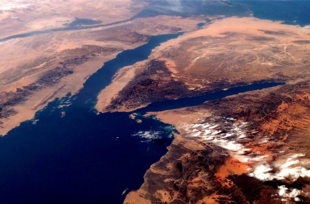
Oblique view of northern Red Sea, Gulf of Suez (top center), and Gulf of Aqaba (right). Elevated topography of the rift shoulders (dark terrain) are nicely contrasted with the adjacent plains. Nile River snakes its way across the top left; we get a glimpse of Nile delta at top center. Image credit: NASA

Oblique view of northern Red Sea, Gulf of Suez (top center), and Gulf of Aqaba (right). Elevated topography of the rift shoulders (dark terrain) are nicely contrasted with the adjacent plains. Nile River snakes its way across the top left; we get a glimpse of Nile delta at top center. Image credit: NASA

Progression of continental rifting to sea floor spreading creates paired (conjugate) passive margins over which post-rift successions accumulate across crust transitional between fully continental and fully oceanic.

The East African Rift System (EARS) provides one of the best actualistic demonstrations of continental rifting, from nascent domal uplift at its southernmost end, to mature, extensional faulting, volcanism, and sediment-filled grabens in the Ethiopian Rift. Afar Depression appears to be on the verge of transforming to the earliest stage of sea floor spreading.

EARS is part of a geodynamic trio: Red Sea and Gulf of Suez lie northeast, and Gulf of Aden northwest. Afar Depression is their triple junction. The Red Sea – Gulf of Aden combo provide excellent examples of nascent sea floor spreading and the transition from continental rifting to passive margin.  Their present plate tectonic configurations are as follows:
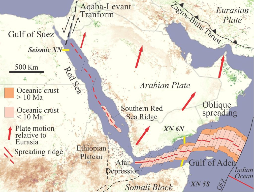
 

Red Sea and Gulf of Aden rift domains. The Red Sea rift axis merges south with a nascent spreading ridge. Sea floor spreading in Gulf of Aden is diachronous with oceanic crust older than 10 Ma at its eastern limit. The pattern of fracture zones and spreading ridge offsets is consistent with oblique spreading and the relative motion of Arabia. Location of the seismic profiles (below) is indicated. Data from Bosworth, 2015.

Red Sea and Gulf of Aden rift domains. The Red Sea rift axis merges south with a nascent spreading ridge. Sea floor spreading in Gulf of Aden is diachronous with oceanic crust older than 10 Ma at its eastern limit. The pattern of fracture zones and spreading ridge offsets is consistent with oblique spreading and the relative motion of Arabia. Location of the seismic profiles (below) is indicated. Data from Bosworth, 2015. The base image is from NASA

  • Continental rifting in Gulf of Suez with rift-parallel listric faults and associated grabens, that merge with;
  • Mature rifting in northern Red Sea, apparently in transition to incipient sea floor spreading that farther south has evolved to
  • Full sea floor spreading in southern Red Sea where 85 km of new oceanic crust has been extruded, plus nascent, conjugate passive margins.  Crustal thickness along the Red Sea margins (depth to Moho) is about 20 km, thinning from 35-40 km in the plate interiors.
  • Sea floor spreading is more advanced in Gulf of Aden and conjugate passive margin successions show some of the characteristics of more mature margins, such as clinoforms.
  • Extension in Red Sea has produced troughs as deep as 2300 m.
  • Rift shoulders line both sides of the rift system, with elevations locally to 3000 m.
  • Northward movement of the Arabian plate (relative to Africa) in concert with rifting, is partly accommodated by left-lateral displacement along the Aqaba-Levant Transform fault (a plate boundary) and underthrusting of the Eurasian plate along the Bitlis-Zagros Thrust.
  • Oblique sea floor spreading in Gulf of Aden has produced en echelon, northeast-striking fracture zones that offset the spreading ridge and partition some of the northward movement of Arabia.


Time line of rifting and sea floor spreading (most of this info is from Bosworth and Burke, 2005; Bosworth, 2015; Nonn et al. 2019):

  1. The beginning of uplift and extension for Red Sea, Gulf of Aden, and EARS was emplacement of a mantle plume beneath Afar about 31 Ma, the eruption of trap basalts, and by 30Ma rhyolites.
  2. Rifting along future Gulf of Aden began soon after, advancing south towards Eritrea by about 27 Ma. Marine deposits (evaporites, limestones) indicate that the fault-controlled basins had access to the sea.
  3. Rifting in southern Red Sea began about 24 Ma, accompanied by extensive, rift-parallel dike intrusion.
  4. Rifting along the entire 4000 km Red Sea – Gulf of Aden system took only 6 million years.
  5. Sea floor spreading began in eastern Gulf of Aden at 19Ma, propagating to the western Gulf by 10 Ma.
  6. Isolation of ancestral Red Sea by 14 Ma led to widespread evaporite deposition that continued to about 5 Ma.
  7. Sea floor spreading began in southern Red Sea at 5 Ma.
  8. Sea floor spreading from Gulf of Aden to Red Sea is highly diachronous; 19 million years so far.

The architecture of nascent passive margins:
Gulf of Suez and Red Sea

Syn-rift sedimentation began with coarse-grained fluvial and alluvial fan deposits that reflect the developing faulted topography, mostly fluvial-alluvial, with a few marine incursions depositing limestone and evaporites. Rapid subsidence subsequently provided access to sea water and the accommodation for thick marls. The Early syn-rift stage ended about mid-Miocene.

Interpreted profile based on reflection seismic, across the western margin of north Red Sea. Syn-rift deposits occupy half grabens bound by listric faults; some faulting has continued into the overlying post-rift succession. There has been significant mobilization of the post-rift salt, including a large detachment at the base of the salt (mid profile). The post-rift succession will be the foundation of a passive margin once sea floor spreading begins in this sector of Red Sea. From Bosworth and Burke, 2005.

Interpreted profile based on reflection seismic, across the western margin of north Red Sea. Syn-rift deposits occupy half grabens bound by listric faults; some faulting has continued into the overlying post-rift succession. There has been significant mobilization of the post-rift salt, including a large detachment at the base of the salt (mid profile). The post-rift succession will be the foundation of a passive margin once sea floor spreading begins in this sector of Red Sea. From Bosworth and Burke, 2005.

The late rift stage was dominated until the end of the Miocene by deposition of thick halite with thin anhydrite, sandstone, and limestone beds. During the Pliocene and Pleistocene, the salts were buried by shale and sandstone. Post-Miocene deposition was strongly influenced by salt mobilisation, that produced salt walls and domes, some more than 3000 m thick.

A basin-wide unconformity is present beneath Pliocene strata. This has been interpreted as a break-up unconformity that records the transition from continental rifting to sea floor spreading in Red Sea. However, Bosworth and others argue that the unconformity correlates with the late Messinian unconformity in the Mediterranean and therefore is more a reflection of the salinity crisis than rift-drift.


Gulf of Aden

Progression of oblique sea floor spreading in Gulf of Aden, although diachronous, has initiated conjugate margins with detectable (on seismic profiles) transitions from continental to oceanic crust.  Depth to the Moho decreases from 35 km inland of the Gulf, to about 20 km in the continental-oceanic crust transition.

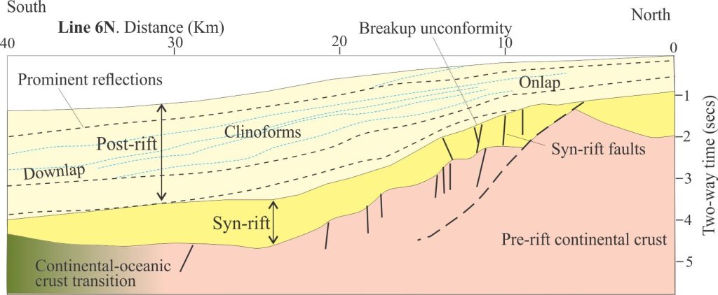
Syn-rift grabens bound by listric faults accommodate coarse-grained clastic, carbonate, and halite-anhydrite deposits 1-2 km thick, and in some troughs >3 km thick. Rotation by syndepositional faulting resulted in numerous stratigraphic discordances.
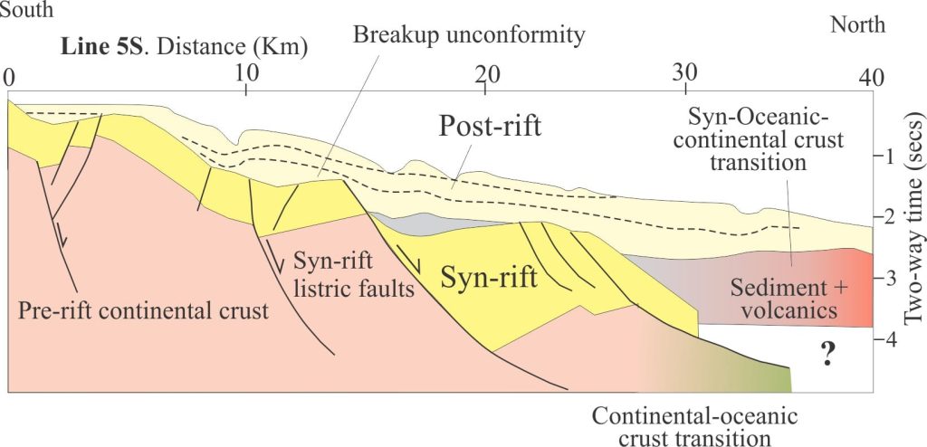


Two profiles across the north (Line 6N) and south (Line 5S) margins of Gulf of Aden interpreted from seismic. Both show the transition from continental crust to crust that is transitional to oceanic. Syn-rift deposits occupy half grabens bound by basin-dipping listric faults, and in turn are unconformably overlain by nascent post-rift, passive margin successions. Prograding clinoforms are well developed in the post-rift succession in Line 6N. Part of the post-rift stage at the basinward end of profile 6N is interpreted as coeval with the continental-oceanic crust transition that probably developed at the beginning of sea floor spreading; the stratigraphic package here includes volcanic accumulations. Modified from Nonn et al. 2019.

Two profiles across the north (Line 6N) and south (Line 5S) margins of Gulf of Aden interpreted from seismic. Both show the transition from continental crust to crust that is transitional to oceanic. Syn-rift deposits occupy half grabens bound by basin-dipping listric faults, and in turn are unconformably overlain by nascent post-rift, passive margin successions. Prograding clinoforms are well developed in the post-rift succession in Line 6N. Part of the post-rift stage at the basinward end of profile 6N is interpreted as coeval with the continental-oceanic crust transition that probably developed at the beginning of sea floor spreading; the stratigraphic package here includes volcanic accumulations. Modified from Nonn et al. 2019.

Volcanism and intrusion have also played a role in shaping both the syn-rift stage, and the stage where crust transitional between fully continental and fully oceanic formed. In Gulf of Aden, volcanism appears to have been more prominent in the West. The influence of volcanism is apparent in profile 5N where syn-rift and post-rift segmentation of the margin has produced small sub-basins and stratigraphic on lap of associated depositional packages.


The overlying paired passive margin successions extend from a depositional edge near the modern coast, to 2-3 km thick offshore. Some seismic profiles show well defined clinoforms with shoreward onlap and basinward downlap geometries. A mid-Miocene unconformity between the syn-rift and post-rift (drift) sedimentary packages is interpreted as a break-up unconformity. Note that this unconformity is older than that in the Red Sea region (end of Miocene).


A companion post looks at the initiation of continental rifting in the East African Rift System (EARS) and a couple of early but relevant models of rift to passive margin transitions.


Topics in this series

Sedimentary basins: Regions of prolonged subsidence

Defining the lithosphere

The rheology of the lithosphere

Isostasy: A lithospheric balancing act

The thermal structure of the lithosphere

Classification of sedimentary basins

Stretching the lithosphere: Rift basins

Basins formed by lithospheric flexure

Accretionary prisms and forearc basins

Basins formed by strike-slip tectonics

Allochthonous terranes – suspect and exotic

Source to sink: Sediment routing systems

Geohistory 1: Accounting for basin subsidence

Geohistory 2: Backstripping tectonic subsidence

Facebooktwitterlinkedininstagram
Facebooktwitterlinkedin

Stretching the lithosphere; Rift basins

Facebooktwitterlinkedininstagram
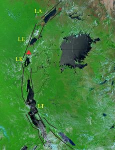
MODIS image (2002) of the western branch of East Africa Rift (EARS). The lakes are contained within fault basins (black lines are approximate fault traces). Nyiragongo volcano is indicated by the red triangle. Lake Victoria lies between the western and eastern branches of EARS. LA = Lake Albert; LE = Lake Edward; LK = Lake Kivu, LT = Lake Tanganyika. The east-west view is about 1200 km.

Annotated MODIS image (2002) of the western branch of East Africa Rift (EARS). The lakes are contained within fault basins (added black lines are approximate fault traces). Nyiragongo volcano is indicated by the red triangle. Lake Victoria lies between the western and eastern branches of EARS. LA = Lake Albert; LE = Lake Edward; LK = Lake Kivu, LT = Lake Tanganyika. The east-west view is about 1200 km.  Base map credit: Jacques Descloitres, MODIS Land Rapid Response Team, NASA/GSFC

Rift basins, ocean basins, and passive margins form a dynamic continuum within the framework of plate tectonics. This post looks at the dynamic – continental rifting and development of nascent oceanic crust in the iconic East Africa Rift System.

Passive margins contain some of the thickest, most extensive sedimentary accumulations on Earth; continent-parallel lengths are measured in 1000s of kilometres, their thickness more than 10 km.  They form at the trailing edge of rifted continental margins; modern configurations underlie shelves and platforms, and adjacent slope. Their seaward limits merge with the ocean abyss. From a geodynamic perspective they represent the transition from continental to oceanic lithosphere.

Passive margins are part of a geodynamic continuum, beginning with continental rifts that eventually broaden via seafloor spreading from nascent, thermally warm oceanic lithosphere to older, colder ocean basins. The plate tectonics perspective describes them as the product of ‘rift-drift’. Actualistic examples of a continental rift, and nascent passive margin and ocean basin are found in the East African Rift System (EARS) and its confluence with Red Sea and Gulf of Aden (a plate boundary triple junction).

Continental rifts

Life as a continental rift begins with stretching of crust and lithosphere mantle, often accompanied by an upwelling mantle plume. The location and trend of a rift zone seems in many cases to be controlled by older structural discontinuities in the crust. The East African Rift is a good example of this pre-existing crustal anisotropy, given its coincidence with an Early Paleozoic fold belt. Continental rifts are regions of high heat flow that in many cases is manifested as volcanism and intrusion.

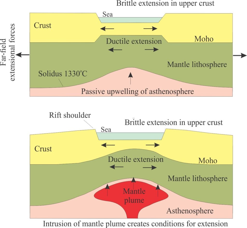
There are two main pathways by which rifting can be initiated:

  • Passive rifting where extension is caused by far-field stresses (generated at plate boundaries but at distance from them), such that buoyant asthenosphere mantle rises passively, partly in response to isostatic compensation, and
  • Active rifting, where rising mantle plumes initiate crustal stretching.
Two primary mechanisms of continental rifting: Passive rifting where mantle passively upwells in (isostatic) response to crustal stretching and thinning; Active rifting where the stretching is a consequence of a rising mantle plume. Modified from Allen and Allen, 2005, Fig. 3.10.

Two primary mechanisms of continental rifting: Passive rifting where mantle passively upwells in (isostatic) response to crustal stretching and thinning; Active rifting where the stretching is a consequence of a rising mantle plume. Modified from Allen and Allen, 2005, Fig. 3.10.

Rift basin subsidence is controlled by brittle failure in upper crustal levels, manifested as basin-margin parallel normal faulting and development of grabens. Border faults are flanked by elevated rims that can produce topographic elevations 100s of metres above the adjacent continental platform.

The grabens form discrete basins that typically fill with coarse-grained clastic sediments derived from the hanging walls of their bounding faults. Faults and fault intersections tend to focus sediment routing. Normal faulting is predominantly listric and fault block rotation during sedimentation results in local stratigraphic discordances. Flank uplifts provide a huge gradient advantage for sediment delivery to the adjacent alluvial and lacustrine settings. Local volcanism ranges from quietly effusive to catastrophic plinian eruptions; they contribute lava flows and volcaniclastics to the local stratigraphy as well as shape rift valley topography. In arid climates, evaporites accumulate in lakes, or marine deposits where there is access to seawater. Lakes, like many in the EARS have extreme chemistries, being either highly alkaline with pH >12 or hyper-acidic (pH < 1).


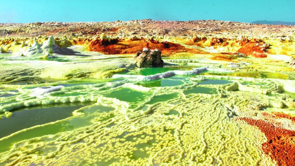
A surreal, Venus-like landscape. Anoxic, hyper-acidic (pH <0), hyper-saline, high temperature (> 108 °C) lake-hydrothermal system associated with Dallol volcano in Afar Depression.

A surreal, Venus-like landscape. Anoxic, hyper-acidic (pH <0), hyper-saline, high temperature (> 108 °C) lake-hydrothermal system associated with Dallol volcano in Afar Depression. Image credit: Electra Kotopoulou 2016

The transition to passive margin and sea floor spreading

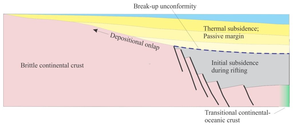
At some point, active rifting of continental lithosphere ceases; the former axis of stretching and brittle failure approximates the axis of sea floor spreading and the production of oceanic lithosphere. This is the drift stage that also sees the accumulation of a thick passive margin succession on the trailing edge of the continental block. This transition is accompanied by lithospheric cooling and a change in the subsidence mechanism from predominantly brittle failure to flexural. Stratigraphically the transition is represented by an unconformity, often called a break-up unconformity.


McKenzie’s pure shear model

One of the earliest numerical geodynamic models to explain the transition was D. McKenzie’s (1978) Steer’s Head model; it us still used as the starting point for more recent models (nicely summarized by Allen and Allen, 2013) – it involves passive rifting. It has been superseded by more sophisticated models, but it serves as a good introduction to understanding the evolution of rift basins and passive margins.

Three important boundary conditions apply to this model (later models change these conditions):

  1. Stretching is uniform and symmetrical, and
  2. There is no rotation of rifted blocks which means conditions of pure shear apply.
  3. Airy isostasy applies.

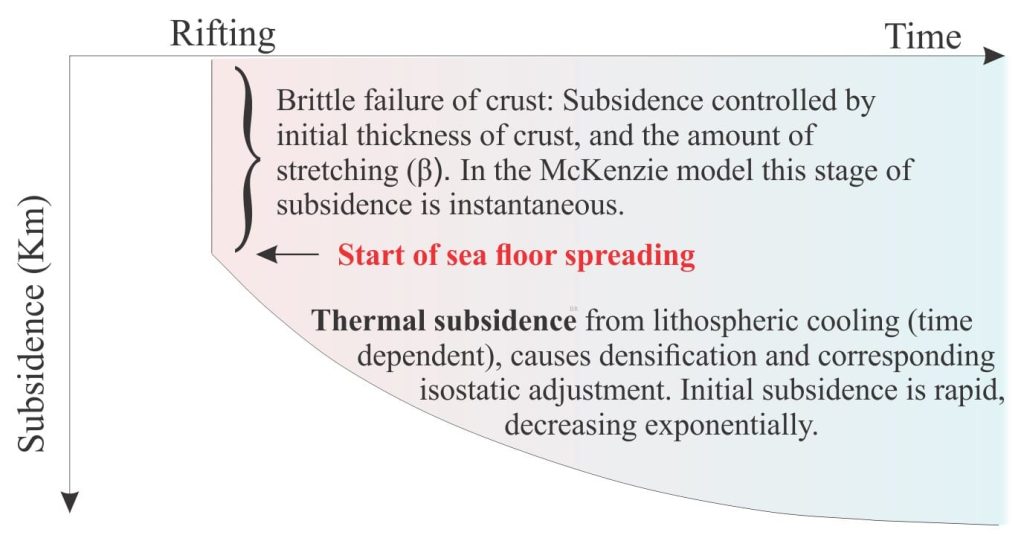
In McKenzie’s model, initial rift-related subsidence is instantaneous. Faulting is dependent on crustal thickness and the amount of stretching that is expressed as β, the stretching factor. β is defined as the ratio of the stretched width and original width. At this point, heat flow in the crust and mantle lithosphere is at some maximum value.

McKenzie’s Steers Head model of continental rifting and thermal subsidence during sea floor spreading. Modified from McKenzie, 1978, Figure 1.

McKenzie’s Steers Head model of continental rifting and thermal subsidence during sea floor spreading. Modified from McKenzie, 1978, Figure 1.

The cessation of stretching coincides with the production of oceanic lithosphere and sea floor spreading. The drifting margin begins to cool but unlike the instantaneous stretching, cooling is time-dependent and exponential. Coincident with cooling is the densification of lithosphere and this requires isostatic compensation that results in thermal subsidence.  The addition over time (100-200 million years) of water and sediment is part of the isostasy equation.

Subsidence curve for the McKenzie model. Initial subsidence by brittle failure of the crust is modelled as instantaneous. Time-dependent subsidence occurs during cooling of the lithosphere.

Subsidence curve for the McKenzie model. Initial subsidence by brittle failure of the crust is modeled as instantaneous. Time-dependent subsidence occurs during cooling of the lithosphere.

Wernicke’s simple shear model

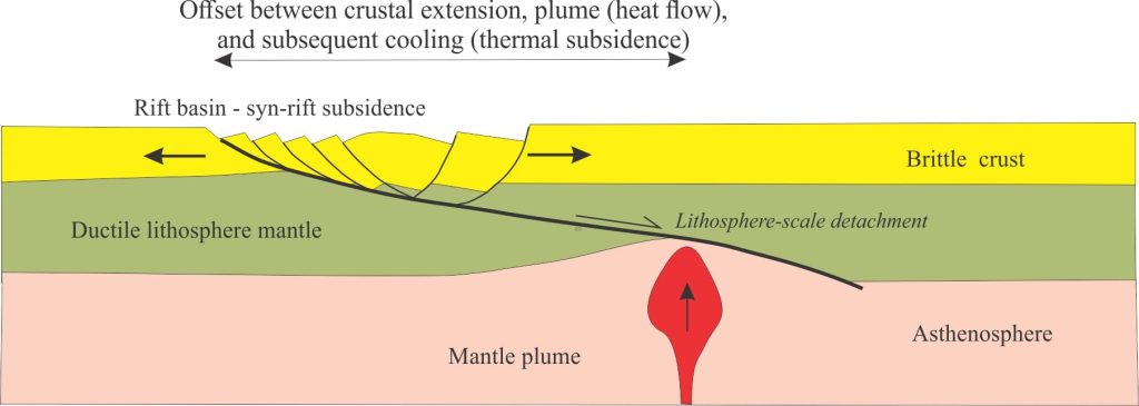
Wernicke’s model of simple shear in the brittle crust, with a rift basin formed in the plate above a lithosphere-scale detachment (fault or fault zone). Note the offset between the rift basin and the heat source from a mantle plume. Modified from Allen and Allen 2005, Figure 3.21 c.

Wernicke’s model of simple shear in the brittle crust, with a rift basin formed in the plate above a lithosphere-scale detachment (fault or fault zone). Note the offset between the rift basin and the heat source from a mantle plume. Modified from Allen and Allen 2005, Figure 3.21 c.

This is one of the early modifications to McKenzie’s model. In contrast, it is asymmetrical and involves simple shear. It is also passive, in that asthenospheric upwelling passively responds to stretching.

Wernicke’s model (1981) of initial continental rifting employs a major, low-angle detachment (in this case a normal fault or shear zone) that extends from the surface to the base of the mantle lithosphere. Displacement along the detachment induces crustal thinning and brittle failure that is manifested as a series of inward-dipping listric faults. Concomitant displacement in the mantle lithosphere is by ductile flow. The geometric requirements of displacement along the main detachment also mean that crustal blocks rotate. Lithospheric thinning also requires isostatic adjustment that is accomplished by (passive) asthenosphere upwelling, and rift subsidence. However, this introduces another critical difference between the two models. In the Wernicke model, extension in the upper crust occurs in the hanging wall of the detachment, but in the footwall at depth in the mantle lithosphere; this means that upwelling asthenosphere is displaced from the main region of rift basin subsidence. This implies that the rift basin will experience little or no volcanism.


EARS – the archetypal continental rift

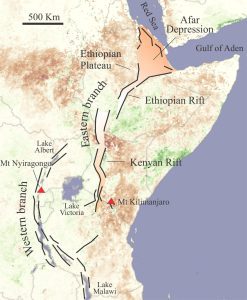
EARS extensional faults from Afar Depression south, that distinguish the eastern and western branches of the rift zone. Base image from NASA

EARS extensional faults from Afar Depression south, that distinguish the eastern and western branches of the rift zone. Base image from NASA

The EARS extends more than 5000 km south from its triple junction with the Red Sea – Gulf of Aden confluence. It defines a geologically young rift boundary between the African (Nubian) and Somalian-Indian plates. It is not a continuous, coherent zone of crustal stretching, but contains several rifts that comprise two main sectors:  a volcanic Eastern branch that includes the Afar Triangle, Ethiopian Rift and Kenya Rift, and a younger Western branch that is less volcanic, and extends from Lake Albert, south in a gentle arc to Lake Malawi. Volcanism and high heat flow are generated by mantle plumes that are hypothesized to be part of a much larger African Superswell (mantle) that underlies much of Africa.

Celebrated volcanoes include Kilimanjaro at the south end of Kenya Rift (Eastern Branch of EARS), a 5885 m behemoth that is a composite of three stratovolcanoes. Its last eruption was about 150,000 years ago. It is associated with more than 250 satellite cones along the rift zone.

Nyiragongo volcano, south of Lake Kivu in the Western branch, is one of the more active stratovolcanoes with the world’s largest caldera lava lake. It erupts very fluid, ultramafic lavas, very low in silica (not many feldspars). Geologist Chris Jackson (Univ. Manchester) recently abseiled into the active crater; check out this video account!


Seething Nyiragongo crater lake; currently the longest lasting. Image credit: Cai Tjeenk Willink, 7 May 2011,

Seething Nyiragongo crater lake; currently the longest lasting. Image credit: Cai Tjeenk Willink, 7 May 2011.

Rifting has progressed from north to south, with mature continental lithosphere extension in the Afar region that appears to be in transition to sea floor spreading. The rate of southwards rift propagation has been estimated between 25-50 mm/year.

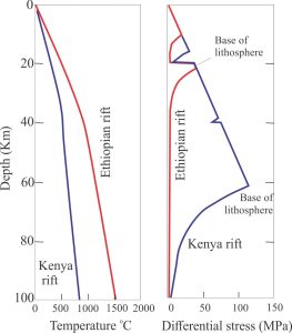
The difference in rift maturity between the Ethiopian and Kenyan sectors, along the length of the Eastern Branch, is illustrated by their geothermal and rheology profiles. In the Ethiopian sector, lithospheric strength is contained entirely in the crust.

Geotherms and lithosphere-asthenosphere strength envelopes for the Kenyan and Ethiopian rifts, showing the marked difference in heat production and lithosphere thickness with progression of rifting. Modified from Ring, 2015, Fig. 6.

Geotherms and lithosphere-asthenosphere strength envelopes for the Kenyan and Ethiopian rifts, showing the marked difference in heat production and lithosphere thickness with progression of rifting. Modified from Ring, 2015, Fig. 6.

Evidence from earthquake focal mechanisms suggests that rifting is still propagating southwards. Incipient sea-floor spreading and production of oceanic crust is taking place in southern Red Sea and Gulf of Aden.

Here is a generalised timeline for EARS development (Info gleaned from U. Ring, 2014; J. Chorowicz, 2005; W. Bosworth, 2015:

  • Activity in the Eastern branch began about 31 Ma (Oligocene) with mantle hotspot effusion of trap-like lava flows in Afar Depression, indicating either incipient extension from far-field stresses that allowed magma to rise, or extension generated by the rising mantle plume. Rifting in the Gulf of Aden began soon after (29.9 – 28.7 Ma), and Red Sea (27.5 – 23Ma).
  • Volcanism and normal listric faulting initiated in the North Kenya region about 20Ma.
  • Active rifting in the Western branch lagged that of the Eastern, beginning 12.6Ma.
  • Volcanism and extension in Ethiopian Rift at 11 Ma (between Afar and North Kenya). Ethiopian Rift is the northernmost sector of the Eastern Branch of EARS.
  • Between 11 and 2 Ma the centre of Ethiopian Rift extended about 20 km. Lithosphere mantle appears to have thinned drastically (based in seismic data). Since 2 Ma deformation and volcanism have concentrated along the rift axis.
  • At present, in Afar Depression we appear to be witnessing the transition from continental extension to incipient sea floor spreading; sea floor spreading is already underway in southern Red Sea and Gulf of Aden with concomitant development of passive margins.

A companion post – Nascent conjugate, passive margins looks at the progression of continental rifting to nascent sea floor spreading in Red Sea, more advance accumulation of oceanic crust in Gulf of Aden, and the beginnings of conjugate passive margins. Afar Depression is a triple point for these three rift systems.


Topics in this series

Sedimentary basins: Regions of prolonged subsidence

Defining the lithosphere

The rheology of the lithosphere

The thermal structure of the lithosphere

Isostasy: A lithospheric balancing act

Classification of sedimentary basins

Nascent conjugate, passive margins

Basins formed by lithospheric flexure

Accretionary prisms and forearc basins

Basins formed by strike-slip tectonics

Allochthonous terranes – suspect and exotic

Source to sink: Sediment routing systems

Geohistory 1: Accounting for basin subsidence

Geohistory 2: Backstripping tectonic subsidence
Facebooktwitterlinkedininstagram
Facebooktwitterlinkedin